Science & Technology
Remote Sensing and India’s IRS Programme
For Prelims: Remote sensing, Synthetic Aperture Radar, Normalised Difference Vegetation Index, Hyperspectral sensors, Yuktdhara geoportal
For Mains: Role of remote sensing in sustainable natural resource management, Indian Remote Sensing (IRS) Programme, Applications of satellite technology in agriculture, water, and forestry
Why in News?
Remote sensing is gaining importance as it enables scientists and policymakers to map, monitor, and manage Earth’s valuable natural resources from space, offering faster, cost-effective, and environmentally sustainable insights into forests, water, minerals, and energy resources.
What is Remote Sensing?
- About: Remote sensing is the science of observing and analysing the Earth from space or air using satellites and drones that detect reflected or emitted electromagnetic radiation.
- Since different materials reflect energy differently, each object has a unique spectral signature, allowing scientists to identify vegetation, water, minerals, rocks, and soil without direct physical contact.
Applications of Remote Sensing
- Vegetation, Crops, and Forests: Healthy plants absorb red light and reflect near-infrared light due to chlorophyll.
- Using this property, satellites compute the Normalised Difference Vegetation Index (NDVI) to assess crop health, stress, and disease.
- NDVI measures vegetation health by comparing reflected near-infrared light and absorbed red light. Higher values indicate healthy vegetation, while lower values show stress or sparse cover.
- Spectral analysis helps distinguish tree species and plant communities across large forests.
- Forest mapping enables estimation of biomass and carbon storage, crucial for climate change mitigation.
- Using this property, satellites compute the Normalised Difference Vegetation Index (NDVI) to assess crop health, stress, and disease.
- Surface Water Mapping and Flood Monitoring: To map water bodies from space, scientists use optical indices and Synthetic Aperture Radar (SAR).
- Optical sensors detect water using the Normalised Difference Water Index (NDWI), which is based on reflected sunlight.
- The method relies on the fact that water reflects visible green light but strongly absorbs near-infrared and shortwave-infrared radiation, allowing NDWI to clearly distinguish water bodies from land surfaces.
- Modified NDWI (MNDWI) improves water detection in urban areas by separating water from building shadows.
- Since optical sensors cannot work at night or through clouds, SAR, which uses active radio waves, is used to map floods during cyclones and heavy rainfall, with calm water appearing dark in radar images.
- SAR-based flood maps support early warning systems for floods, droughts, cyclones, and landslides, and help governments plan evacuations, relief logistics, and insurance payouts.
- Satellites also assess water quality by detecting differences in reflectance caused by sediments, pollution, and algal blooms.
- Optical sensors detect water using the Normalised Difference Water Index (NDWI), which is based on reflected sunlight.
- Mineral Exploration: Hyperspectral sensors split sunlight into hundreds of narrow wavelengths, generating a spectral signature for every pixel.
-
This allows identification of specific minerals such as copper, gold, lithium, limestone, and granite.
- Satellites map alteration zones, where underground heat and fluids modify surface rocks, aiding mineral exploration.
-
- Oil and Gas Exploration: Hydrocarbons may leak upward through micro-seepage, where small hydrocarbon leaks subtly alter soil chemistry and vegetation health, helping identify areas with potential underground reserves, which satellites can detect.
- When micro-seepage is absent, satellites cannot detect oil directly, so they focus on identifying geological structures that can trap oil, such as anticlines and sedimentary basins.
- Using surface rock imagery, gravity, and magnetic data, satellites map thick sedimentary layers and underground formations that indicate areas capable of holding oil and gas, not their confirmed presence.
- It is used to monitor coral bleaching, mangroves, shoreline erosion, and oil spills, and supports the Blue Economy and coastal zone regulation through continuous, large-scale environmental monitoring.
- When micro-seepage is absent, satellites cannot detect oil directly, so they focus on identifying geological structures that can trap oil, such as anticlines and sedimentary basins.
- Groundwater Monitoring: Large underground aquifers exert a stronger gravitational pull.
- Gravity-measuring satellites can estimate groundwater storage by detecting tiny changes in Earth’s gravity field.
- Remote sensing has revealed severe groundwater depletion, especially in North India, due to excessive irrigation.
- It enables site-specific irrigation, fertiliser use, and pest control, improving crop yields while reducing water use and chemical runoff.
- Sustainable Resource Management: Remote sensing makes exploration faster, cheaper, and environmentally safer by reducing random drilling and excavation.
- It enables continuous monitoring of forests, water, and aquifers to prevent over-exploitation.
- It supports sustainable development by tracking urban heat islands, land-use change, and informal settlement growth, aiding climate-resilient urban planning, disaster management, climate action, and evidence-based policy making.
Indian Remote Sensing (IRS) Programme
- About: The Indian Remote Sensing (IRS) Programme is India’s national Earth observation programme, initiated with the launch of Indian Remote Sensing satellite-1A (IRS-1A) in 1988, to provide satellite imagery for resource management and national development.
- Operated by ISRO, it comprises one of the world’s largest constellations of remote sensing satellites, delivering data across multiple spatial, spectral, and temporal resolutions.
- IRS data supports applications such as agriculture, water resources, urban planning, forestry, mineral exploration, disaster management, ocean studies, and environmental monitoring, and has played a foundational role in building India’s geospatial and GIS ecosystem.
- Key Indian Remote Sensing (IRS) Missions:
- Land & Water Resource Observation Series: IRS-1A/1B/1C/1D, Resourcesat-1, Resourcesat-2/2A, and HysIS (Hyperspectral Imaging Satellite)
- Ocean & Atmospheric Observation Series: Oceansat-1/2, Megha-Tropiques, and SARAL.
- Cartographic Satellite Series: Technology Experiment Satellite (TES), Cartosat-1, Cartosat-2/2A/2B/2S, Cartosat-3
- Microwave Remote Sensing (SAR) Series: RISAT (Radar Imaging Satellite)-1, RISAT-1A, RISAT-2A, and NISAR (NASA–ISRO Synthetic Aperture Radar).
How did Remote Sensing Technology Contribute for Societal Development in India?
- Bhuvan Geoportal: A national geospatial platform by ISRO for visualisation, monitoring, and planning of development projects.
- Geo-MGNREGA: Satellite-based geo-tagging and monitoring of assets created under MGNREGA to improve transparency and planning.
- 6.24 crore+ assets/activities geo-tagged on the Geo-MGNREGA portal.
- Yuktdhara geoportal supports planning of new natural resource assets.
- SIS-DP (Space-based Information Support for Decentralized Planning): Uses high-resolution satellite data to support Panchayat- and village-level planning.
- Watershed Development Component-Pradhan Mantri Krishi Sinchayee Yojana 2.0 (PMKSY-WDC 2.0): Remote sensing for monitoring micro-watersheds and soil–water conservation works.
- Under PMKSY-WDC 2.0, around 1,150 projects were assessed using high-resolution data from Cartosat-2S and Cartosat-3 via Bhuvan tools.
- Rural Road Mapping: Satellite mapping and monitoring of rural roads across India.
- Pradhan Mantri Gram Sadak Yojana dashboard on Bhuvan enables real-time monitoring by the Ministry of Rural Development and State governments.
- PMAY (Urban & Gramin): Uses geospatial monitoring (geotagging) as a core mechanism for ensuring transparency, tracking physical construction progress, and facilitating the stage-wise release of funds.
- Disaster Management Support Programme (DMSP): The DMSP is implemented by ISRO / Department of Space to support national and state disaster management agencies.
- It uses space-based inputs for hazard, vulnerability, and risk (HVR) assessment, disaster monitoring, damage assessment, and early warning systems.
- The programme covers major disasters such as floods, cyclones, landslides, earthquakes, and forest fires, using data from Indian satellites including Resourcesat, Cartosat series, RISAT, Oceansat-3, INSAT-3DR/3DS, along with data from global satellite missions.
What are the Challenges Associated with Remote Sensing in India?
- Data Accessibility and Cost: High-resolution imagery is often costly or restricted, limiting use by states and local bodies.
- For example, many municipalities depend on coarse satellite data for urban planning, reducing accuracy in slum mapping and land-use zoning.
- Cloud Cover and Weather Limitations: Optical satellites struggle during the monsoon season, affecting crop assessment and flood mapping.
- For instance, Kharif crop damage assessment is often delayed due to persistent cloud cover.
- Limited last-mile Application: Satellite insights do not always translate into on-ground action. For example, despite groundwater depletion maps in Punjab and Haryana, over-irrigation continues due to weak policy enforcement.
Skill and Capacity Gaps: Many district administrations lack trained geospatial staff. As a result, disaster early-warning maps are underutilised during floods and cyclones. - Data Fragmentation and Poor Integration: Datasets from ISRO, states, and ministries often operate in silos. For example, urban flood modelling suffers when satellite rainfall data is not integrated with local drainage data.
- Privacy and Security Concerns: High-resolution mapping of border areas and cities raises concerns about national security and individual privacy, especially with growing private-sector participation.
What Measures can Strengthen Remote Sensing in India?
- Integrate Satellite Data with Ground Systems: Expand linking remote sensing with IoT sensors, drones, and GIS dashboards under programmes like Digital India and Smart Cities Mission to enable real-time applications such as precision irrigation, urban flood control, and heatwave management.
- Expand open-access geospatial data: Fully implement the National Geospatial Policy, 2022 to make high-resolution data affordable and accessible.
- Platforms like PM Gati Shakti and Bhuvan (ISRO) already demonstrate how open geospatial layers can support infrastructure planning, logistics, and regional development.
- Promote all-weather monitoring using SAR: Scale up SAR missions such as RISAT for all-weather, day-night monitoring.
- SAR-based flood mapping during cyclones along India’s east coast has strengthened NDMA-led disaster response and early warning systems.
- Strengthen Capacity Building at Local Levels: Expand ISRO’s capacity-building programmes like IIRS training and outreach to state and district officials.
- This will ensure satellite inputs directly guide agriculture advisories, drought assessment, and disaster management at the grassroots level.
Conclusion
- Remote sensing has become a core pillar of India’s development and data driven governance framework, supporting agriculture, disaster management, urban planning, and climate action. As India advances its National Geospatial Policy, remote sensing will remain critical for strengthening both economic growth and environmental security.
|
Drishti Mains Question: Q. Examine the role of the Indian Remote Sensing (IRS) Programme in supporting sustainable development and governance |
Frequently Asked Questions (FAQs)
- What is remote sensing?
Remote sensing is the science of observing Earth from space or air using sensors that detect reflected or emitted electromagnetic radiation. - Why is remote sensing important for India?
It enables cost-effective monitoring of agriculture, water, forests, minerals, disasters, and development programmes at national scale. - What is the Indian Remote Sensing (IRS) Programme?
IRS is India’s national Earth observation programme, launched in 1988, providing multi-resolution satellite data for resource management and governance. - How does remote sensing help in disaster management?
It supports hazard, vulnerability, and risk assessment, real-time disaster monitoring, damage assessment, and early warning using satellite data.
UPSC Civil Services Examination, Previous Year Question (PYQ)
Prelims
Q.1 In the context of space technology, what is “Bhuvan”, recently in the news? (2010)
(a) A mini satellite launched by ISRO for promoting the distance education in India
(b) The name given to the next Moon Impact Probe, for Chandrayaan-II
(c) A geoportal of ISRO with 3D imaging capabilities of India
(d) A space telescope developed by India
Ans: c
Mains
Q.1 What is India’s plan to have its own space station and how will it benefit our space programme? (2019)
Q.2 Discuss India’s achievements in the field of Space Science and Technology. How the application of this technology helped India in its socio-economic development? (2016)


Facts for UPSC Mains
Year-End Review 2025: Department of Justice
Why in News?
The Department of Justice's 2025 annual review highlighted its key achievements in modernizing India's legal landscape through a multi-pronged strategy focused on judicial appointments, digital transformation, legal aid expansion, and infrastructure development.
What are the Key Achievements of the Department of Justice in the Year 2025?
- Strengthening Judicial Capacity: In 2025, 157 new Judges were appointed to High Courts, led by Allahabad (40), Bombay (21), Madhya Pradesh (15), and Rajasthan (15), while 47 Additional Judges were made permanent and 13 had their tenures extended.
- Additionally, 12 new Chief Justices were appointed and 44 inter-High Court judge transfers were effected to optimize expertise distribution.
- Expanding Legal Access: Tele law (legal advice over telephone or video conferencing) has achieved massive geographical penetration by covering 2.5 lakh Gram Panchayats across 776 districts and provided pre-litigation advice to over 1.12 crore beneficiaries.
- District level workshop and training conducted in 638 districts training over 37,000 participants, and concluded with the Hamara Samvidhan Hamara Samman campaign (to inculcate constitutional values) reaching 70.70 lakh people.
- Legal Aid Schemes for Vulnerable Groups: New schemes launched included the Veer Parivar Sahayata Yojana for defence personnel in Srinagar and the NALSA Scheme for Victims of Human-Wildlife Conflict.
- The Supporting Potential and Resilience of the Unseen, Held-back and Affected (SPRUHA) Scheme was introduced for dependents of prisoners and crime victims, and marking 30 years of NALSA, a Community Mediation Training Module was also launched.
- Digital Transformation of Courts: India has become a global leader in virtual hearings with over 3.91 crore conducted, and enhanced citizen access via 1,987 eSewa Kendras and the e-Courts mobile app with 3.38 crore downloads.
- Under the eCourts Phase-III project, over 92 lakh cases were filed electronically, and Rs 1,215 crore was collected as online court fees.
- Enhancing Efficiency in Justice Delivery: Operationalized 774 Fast Track Special Courts (FTSCs), including 398 exclusive POCSO courts, in 29 States/UTs. These courts disposed of 3.6 lakh cases since inception, with a 2025 disposal rate of 7.41 cases/month/court—more than double the rate of regular courts (3.18 cases/month/court).
- Infrastructure and Monitoring Systemic Reforms: Physical infrastructure was dramatically improved, with Court Halls increasing to 22,663 and Residential Units to 20,033 from 2014 baselines of 15,818 and 10,211 respectively.
- Real-time monitoring is enabled via the Nyaya Vikas Portal 2.0, and geotagging 94.66% of projects, while engagement in the World Bank's B-READY framework assessments aims to improve India's global standing in dispute resolution.
National Legal Services Authority (NALSA)
- About: NALSA is a statutory body constituted in 1995 under the Legal Services Authorities Act, 1987, to monitor, evaluate, and implement legal aid programmes across India. It has completed 30 years in 2025.
- The Chief Justice of India (CJI) is the Patron-in-Chief of NALSA.
- Constitutional Mandate: Formed to give effect to Article 39A of the Constitution of India, which mandates the State to provide free legal aid to ensure equal justice and opportunities for all citizens, particularly those with economic or other disabilities.
- Also upholds the obligations under Article 14 (equality before law) and Article 22(1) (rights to be informed of grounds for arrest).
- Primary Functions: Lay down policies and principles for making legal services available under the Legal Services Authorities Act, 1987.
- Monitor and evaluate the implementation of legal aid programmes across India.
- Disburse funds and grants to State Legal Services Authorities (SLSAs) and Non-Governmental Organisations (NGOs) for implementing legal aid schemes and programmes.
- Integrated Network: NALSA is the apex body of a nationwide network envisaged under the Legal Services Authorities Act, 1987 for providing legal aid and assistance. This network includes:
- State Legal Services Authorities (SLSAs): Headed by the Chief Justice of the respective High Court (Patron-in-Chief).
- District Legal Services Authorities (DLSAs): Chaired by the District Judge of the respective district.
- Taluk/Sub-Divisional Legal Services Committees: Headed by a senior civil judge.
- High Court Legal Services Committees and the Supreme Court Legal Services Committee.
- Eligible Groups: Women and Children, Members of Scheduled Castes (SC) and Scheduled Tribes (ST), Economically Weaker Sections (EWS), Industrial Workers, Disabled Persons and Other specified categories.
Conclusion
The year 2025 was marked by a holistic approach that combined capacity building (judges), technological depth (eCourts), grassroots reach (Tele-Law), specialized aid (new schemes), physical infrastructure, and process efficiency (FTSCs). This multi-directional effort signifies a year of substantial progress in making justice more accessible, efficient, and inclusive for all citizens.
|
Drishti Mains Question: Q. Assess the multifaceted initiatives undertaken by the Department of Justice in 2025 to enhance judicial capacity, legal aid, and access to justice in India |
Frequently Asked Questions (FAQs)
1. What is the Tele-Law initiative and its reach in 2025?
Tele-Law provides pre-litigation legal advice and in 2025 covered 2.5 lakh Gram Panchayats across 776 districts, benefiting over 1.12 crore citizens.
2. Which key legal aid schemes were launched by NALSA in 2025?
Veer Parivar Sahayata Yojana for defence personnel, Human-Wildlife Conflict Scheme, and SPRUHA Scheme for dependents of prisoners and crime victims were launched.
3. What are the major achievements of the eCourts Phase-III project in 2025?
Over 92 lakh e-filings, digitization of 579 crore pages, 3.91 crore virtual hearings, and 1,987 eSewa Kendras enhanced access and transparency in justice delivery.
4. How many Fast Track Special Courts were operationalized in 2025 and what was their impact?
774 FTSCs, including 398 POCSO courts, disposed 3,61,055 cases with an average rate of 7.41 cases/month/court, outperforming regular courts.
UPSC Civil Services Examination Previous Year Question (PYQ)
Prelims
Q. With reference to the Indian judiciary, consider the following statements: (2021)
- Any retired judge of the Supreme Court of India can be called back to sit and act as a Supreme Court judge by the Chief Justice of India with the prior permission of the President of India.
- A High Court in India has the power to review its own judgement as the Supreme Court does.
Which of the statements given above is/are correct?
(a) 1 only
(b) 2 only
(c) Both 1 and 2
(d) Neither I nor 2
Ans: (c)
Q. With reference to National Legal Services Authority, consider the following statements: (2013)
- Its objective is to provide free and competent legal services to the weaker sections of the society on the basis of equal opportunity.
- It issues guidelines for the State Legal Services Authorities to implement the legal programmes and schemes throughout the country.
Which of the statements given above is/are correct?
(a) 1 only
(b) 2 only
(c) Both 1 and 2
(d) Neither 1 nor 2
Ans: (c)
Mains
Q. Who are entitled to receive free legal aid? Assess the role of the National Legal Services Authority(NALSA) in rendering free legal aid in India. (2023)
Q. Critically examine the Supreme Court’s judgement on ‘National Judicial Appointments Commission Act, 2014’ with reference to appointment of judges of higher judiciary in India. (2017)


Important Facts For Prelims
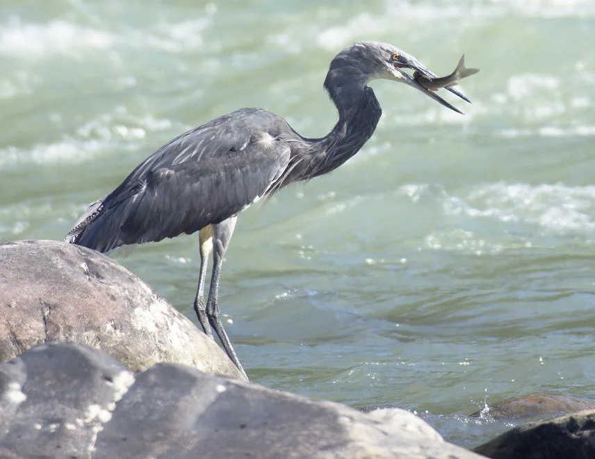
White-bellied Heron and Kalai-II Project
Why in News?
The environmental clearance (EC) for the 1,200-MW Kalai-II hydropower project on the Lohit River in Arunachal Pradesh (AR) has triggered concerns over serious omissions in the Environmental Impact Assessment (EIA), particularly regarding the critically endangered white-bellied heron.
What are White-bellied Herons?
- About: The White-bellied Heron (Ardea insignis), also known as the imperial heron or great white-bellied heron, is a large species of heron in the family Ardeidae. It is recognized as the 2nd-largest heron in the world.
- Habitat: Strictly dependent on free-flowing, fast-flowing eastern Himalayan riverine habitats with low human disturbance. Feeds mainly on fish found in river rapids, making it highly sensitive to dams and flow alterations.
- Morphological Features: Longer, flexible neck with razor-sharp serrated bill for catching fish in deep waters.
- Compact body with shorter legs for stability in fast currents. Extended toes to grip slippery rocks—an adaptation to turbulent river habitats.
- Conservation Status: Critically Endangered species as per the IUCN Red List.
- Schedule-I species (highest legal protection in India) under the Wildlife Protection Act, 1972.
- Global & Regional Population: Distributed across ~165,000 km² of Himalayan freshwater ecosystems spanning Bhutan, India, Myanmar, China, and Bangladesh. Fewer than 60 individuals survive in the wild today.
- Bhutan hosts ~45% of the global population, with 3–5 active breeding pairs, making it the species’ last stronghold.
- It is considered extinct in Nepal and possibly Bangladesh.
- Distribution in India: It is found in Arunachal Pradesh (Lohit, Anjaw, and Changlang districts). Recorded in and around Namdapha Tiger Reserve (AR) and Kamlang Tiger Reserve (AR). Sightings recorded along the entire Lohit River stretch.
- Behavior: It is largely solitary, vocalizing with deep croaks mainly at dawn and dusk, and nests in tall trees.
-
Ecological Significance: It serves as a bio-indicator for the Himalayan freshwater ecosystem, reflecting factors like water quality, fish populations, pollution, and habitat integrity. Its decline signals broader ecosystem degradation and collapsing food chains.
- Major Threats: Hydropower dams (habitat fragmentation, altered river flows), habitat loss, hunting, and anthropogenic disturbances. Very small gene pool and restricted distribution range.
What is the Kalai-II Hydropower Project?
- About: It is a proposed 1,200 MW run-of-river hydroelectric project with pondage (small storage capacity) on the Lohit River, a major tributary of the Brahmaputra, located in Anjaw district, Arunachal Pradesh.
- It is being developed by Tehri Hydro Development Corporation India Limited.
- Development History: Initially allotted to a private developer, the project stalled for years before being revived in 2023–24 and transferred to THDC India Limited by the Arunachal Pradesh government.
- It is among 13 stalled hydropower projects reassigned to central PSUs for faster execution.
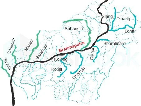
Lohit River
- About: The Lohit River is a right-bank tributary of the Brahmaputra River, originating in the Kangri Karpo range of eastern Tibet, where it is known as Zayul Chu.
- Course: It enters India near Kibithu in Arunachal Pradesh (India’s easternmost inhabited point), flows southward through the Mishmi Hills in Anjaw and Lohit districts, and emerges into the Assam plains near Parasuram Kund and Sadiya.
- It flows through protected areas such as Kamlang Wildlife Sanctuary (AR) and Mehao Wildlife Sanctuary (AR).
- Confluence: It joins the Siang (upper Brahmaputra) and Dibang rivers near Kobo in Assam to form the main Brahmaputra stem.
- Hydroelectric Power Projects: Kalai-II Hydroelectric Project (1,200 MW), Demwe Lower Hydroelectric Project (1,750 MW, now stalled), Hutong (proposed), Demwe Upper (proposed).
Frequently Asked Questions (FAQs)
1. What is the conservation status of the White-bellied Heron?
It is Critically Endangered (IUCN Red List) and a Schedule-I species under the Wildlife Protection Act, 1972.
2. Where is the White-bellied Heron found in India?
Mainly in Arunachal Pradesh—Lohit, Anjaw, and Changlang districts, including Namdapha and Kamlang Tiger Reserves.
3. How do hydropower dams threaten the White-bellied Heron?
By altering river flow, fragmenting habitats, reducing fish availability, and increasing human disturbance.
UPSC Civil Services Examination, Previous Year Questions (PYQs)
Q. With reference to India’s Desert National Park, which of the following statements are correct? (2020)
- It is spread over two districts.
- There is no human habitation inside the Park.
- It is one of the natural habitats of Great Indian Bustard.
Select the correct answer using the code given below:
(a) 1 and 2 only
(b) 2 and 3 only
(c) 1 and 3 only
(d) 1, 2 and 3
Ans: (c)
Q. Which one of the following National Parks has a climate that varies from tropical to subtropical, temperate and arctic? (2015)
(a) Khangchendzonga National Park
(b) Nandadevi National Park
(c) Neora Valley National Park
(d) Namdapha National Park
Ans: (d)


Rapid Fire
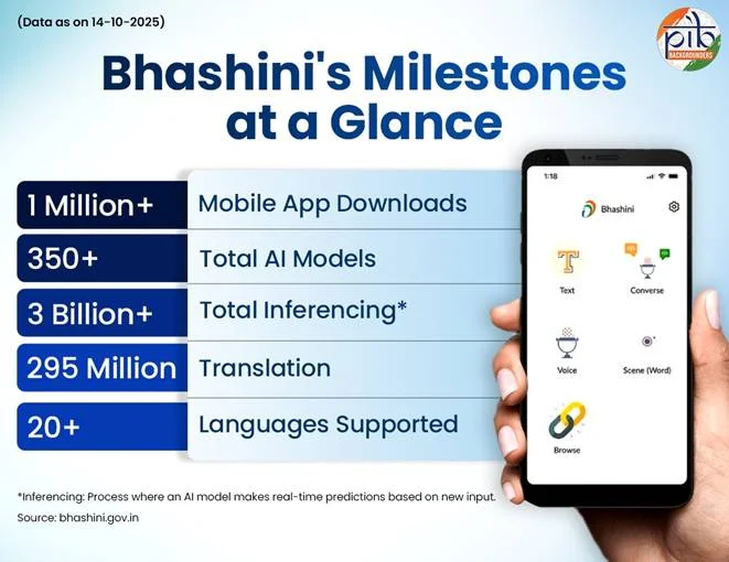
BHASHINI's Shrutlekh Multilingual Translation Tool
The Ministry of Electronics and Information Technology (MeitY) demonstrated Digital India BHASHINI’s AI tool, Shrutlekh, by using it for real-time multilingual speech-to-text translation during key speeches.
Shrutlekh
- About: Shrutlekh is an AI-powered tool developed under India's BHASHINI (BHASHa INterface for India) platform, initiated by the MeitY as part of the National Language Translation Mission.
- Function: It functions as a real-time speech-to-text transcription and multilingual translation system, enabling Automatic Language Detection (ALD), transcription of spoken content, and Live Translation Display into various Indian languages.
BHASHINI (BHASHa INterface for India)
- About: BHASHINI is India’s AI-powered platform designed to break down language barriers and create a language-inclusive digital India.
- Objective: Its core mission is to enable citizens to access digital content and services in their preferred Indian languages, promoting digital inclusion across governance, education, and healthcare.
- Scope & Accessibility: The platform supports over 22 scheduled Indian languages and features tools like Shrutlekh (speech-to-text), document translation, and a crowdsourcing initiative (Bhashadaan) for data contribution.
- Real-World Integration: BHASHINI is a key pillar of India's Digital Public Infrastructure, enabling language-layer interoperability alongside Aadhaar, UPI, and DigiLocker. It has been deployed for real-time speech translation in governance on portals like e-Shram, for conversational UPI payments, and at major public events.
| Read More: Tech-Driven Multilingual Inclusion in India |


Rapid Fire
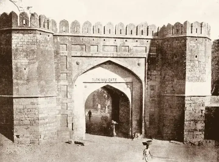
Turkman Gate
Turkman Gate is in the news following a recent demolition drive that turned violent, recalling the Emergency (1975–77) when the area witnessed forced demolitions and coercive sterilisation drives, later examined by the Shah Commission.
- About: Turkman Gate was one of the 14 gates of Shahjahanabad, the walled city founded by Mughal emperor Shah Jahan in the mid-17th century (around 1650 AD).
- It was named after the Sufi saint Hazrat Shah Turkman Bayabani, whose mausoleum lies in the vicinity, giving the area enduring cultural and religious significance.
- History: The significance of Turkman Gate predates Mughal Delhi. The area formed part of an important pre-existing urban and spiritual landscape, reflecting Delhi’s role as a major centre of Sufism.
-
The saint Shah Turkman Bayabani is traditionally associated with early ascetic Sufi traditions in Delhi, and the proximity of Razia Sultan’s grave to his shrine indicates the reverence attached to the site over centuries.
-
-
Location: The gate stood along a key arterial route linking Fatehpuri Masjid – Hauz Qazi – the old Yamuna belt, a thoroughfare that was incorporated into Shahjahanabad’s urban design. Today, it is located in Old Delhi, near Jama Masjid.
-
Significance: Like other gates of the walled city, Turkman Gate served both defensive and commercial functions, protecting the city from external threats while regulating the movement of people and goods.
-
It survived major historical disruptions, including the Revolt of 1857, colonial-era demolition of city walls, Partition, and subsequent commercial restructuring.
-
| Read more: Indo-Islamic Architecture |


Rapid Fire
Avian Flu
A fresh outbreak of avian influenza (H5N1) in Kuttanad, Kerala has once again disrupted its centuries-old duck-rearing tradition, raising serious concerns about livelihoods, biodiversity, and rural sustainability.
- The latest outbreak has already killed ~55,000 birds, with another 25,000 set to be culled as a preventive measure.
- Indigenous duck breeds like Chara and Chembally face a risk of local extinction.
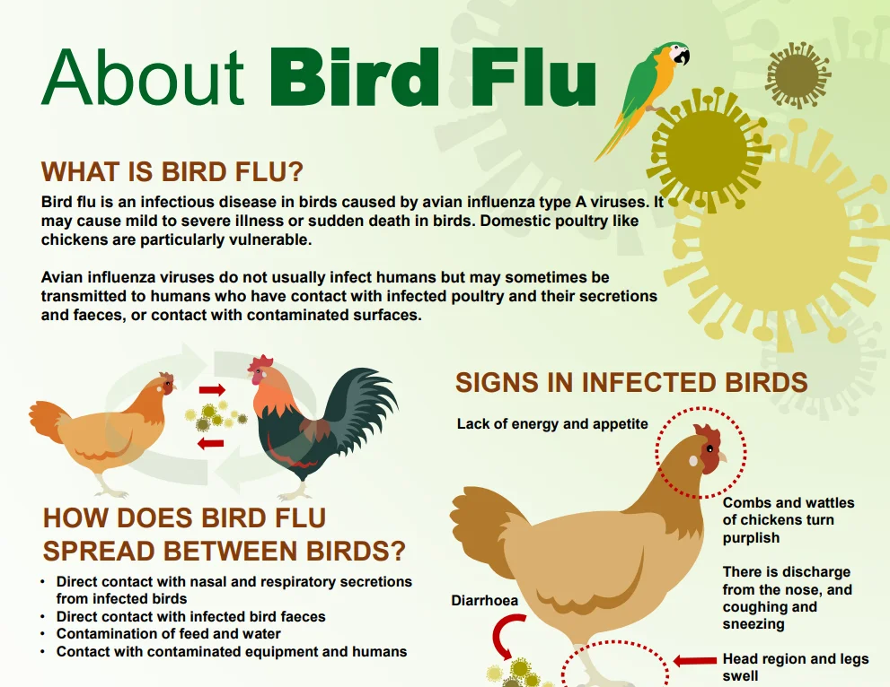
- Avian influenza A(H5N1): It is a highly pathogenic virus that primarily circulates among birds but can also infect mammals.
- History: First detected in China in 1996, it has since evolved into a global threat. India reported its first outbreak in Maharashtra and Gujarat in 2015.
- Transmission: Human infection with avian influenza is rare and occurs mainly through direct contact with infected birds or their secretions, especially in poultry farms and live bird markets.
- Symptoms: Common symptoms include high fever, cough, sore throat, and muscle aches.
- Severe cases may progress to respiratory failure or neurological complications, while some exposed individuals remain asymptomatic.
- Treatment: Antiviral drugs such as oseltamivir are effective, particularly when given early in severe or high-risk cases.
| Read more: H5N1 Bird Flu |


Rapid Fire
e-B-4 Business Visa for Chinese Nationals
India has introduced an e-Production Investment Business Visa (e-B-4) for Chinese nationals, allowing fully online travel for production- and investment-related business activities without requiring embassy visits.
- Coverage: The visa permits activities such as installation and commissioning of equipment, quality checks, essential maintenance, production, Information Technology(IT) and Enterprise Resource Planning(ERP) ramp-up, training, supply-chain development, empanelling of vendors, plant design and bring-up, and travel of senior management and executives.
- Processing and Validity: The visa is issued within 45–50 days of application and permits a stay of up to six months in India.
- Application Mechanism: Applicants can apply online through the Bureau of Immigration’s e-Visa portal, while Indian companies inviting Chinese professionals can register on DPIIT’s National Single Window System (NSWS).
- Significance: The move is part of recent people-centric measures agreed by India and China to reset bilateral ties, facilitating smoother business mobility and supporting investment-linked economic engagement.
| Read more: Evolving Landscape of India-China Relations |


Rapid Fire
Spina Bifida
Recently, health experts highlighted that India has one of the world’s highest prevalence rates(~4 per 1,000 births) of Spina Bifida, with over 25,000 children affected every year.
- About: Spina Bifida is a congenital neural tube defect in which the spinal cord fails to close completely during early fetal development.
- Symptoms: Affected children may develop hydrocephalus (excess fluid in the brain), urinary and bowel incontinence(lack of control), a visible swelling or lump on the baby’s back, club foot and other orthopaedic deformities, with severity ranging from mild weakness to complete paraplegia.
- Impact: It leads to partial or complete paralysis of the lower limbs, often resulting in wheelchair-dependence from early childhood. Though their intellectual abilities remain normal, over 75% of affected children in India lack access to specialised medical and surgical care, pushing families into prolonged financial and emotional distress. The condition significantly increases under-five mortality, disability burden, and long-term healthcare costs.
- Prevention: Global medical evidence since 1991 confirms that periconceptional folic acid supplementation can prevent over 70% of Spina Bifida cases.
- Emerging Research: Recent studies indicate that fortifying commonly consumed beverages like tea with folate and Vitamin B12 could help prevent anaemia and neural tube defects in India.
| Read more: Neurological Disorders in India |


