Governance
National Geospatial Policy 2022
- 06 Jan 2023
- 8 min read
Prelims: Geospatial Technology, Remote Sensing, SDG.
Mains: National Geospatial Policy 2022, its significance and related Concerns.
Why in News?
The Ministry of Science and Technology has notified a National Geospatial Policy (NGP) 2022, with the goal of making India a world leader in the Global Geospatial Sector.
- India's geospatial economy is expected to cross Rs 63,000 crore by 2025 at a growth rate of 12.8% and to provide employment to more than 10 lakh people.
What is Background?
- In 2021, the Ministry of Science and Technology issued “Guidelines for acquiring and producing Geospatial Data and Geospatial Data Services including Maps”.
- While the Guidelines deregulated the Geospatial sector by liberalizing Geospatial data acquisition/production/ access, the 2022 Policy takes it further by laying down an overarching framework for holistic development of the Geospatial ecosystem.
What is National Geospatial Policy 2022?
- About:
- It is a citizen-centric policy based on Geo-Spatial technology, which seeks to strengthen the Geospatial sector to support national development, economic prosperity and a thriving information economy.
- The policy is aimed to set up high resolution topographical survey and mapping, with a high-accuracy Digital Elevation Model (DEM) by 2030.
- Vision and Goals:
- It aims to make India a World Leader in Global Geospatial space with the best in the class ecosystem for innovation.
- To develop a coherent national framework in the country and leverage it to move towards a digital economy and improve services to citizens.
- To develop Geospatial infrastructures, Geospatial skill and knowledge, standards, Geospatial businesses.
- To promote innovation and strengthen the national and sub-national arrangements for generation and management of Geospatial information.
- Institutional framework:
- A Geospatial Data Promotion and Development Committee (GDPDC) at the national level shall be the apex body for formulating and implementing strategies related to promotion of the Geospatial sector.
- GDPDC would replace and subsume the functions and powers of the National Spatial Data Committee (NSDC) constituted in 2006 and GDPDC constituted in 2021.
- Department Of Science & Technology shall continue to be the nodal Department of the Government and GDPDC shall make suitable recommendations to DST in the discharge of its functions relating to the Geospatial regime.
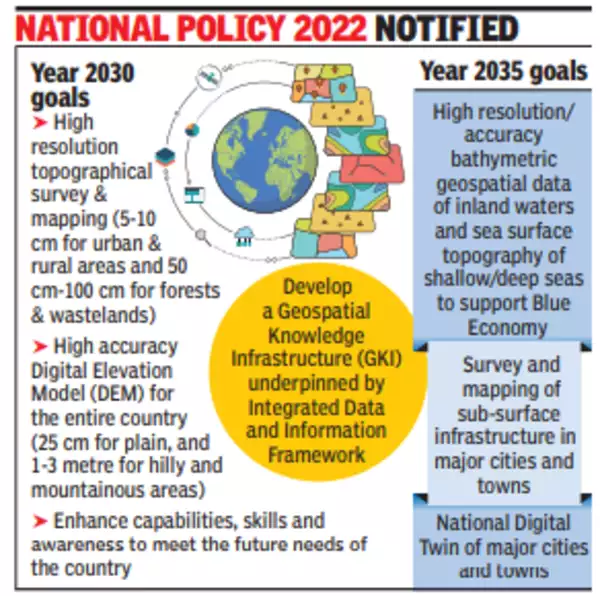
- Milestones towards Realization of the Policy’s Vision:
- Year 2025:
- Put in place an enabling policy and legal framework that supports liberalization of Geospatial sector and democratization of data for enhanced commercialization with Value Added Services.
- Year 2030:
- High resolution topographical survey & mapping (5-10 cm for urban & rural areas and 50 cm-100 cm for forests & wastelands).
- Year 2035:
- High resolution/accuracy Bathymetric Geospatial Data of inland waters and sea surface topography of shallow/deep seas - to support Blue Economy.
- National Digital Twin of major cities and towns. The Digital Twin is a virtual replica of a physical asset, process or service that lies at the core of the new digital revolution.
- National Digital Twin would be an ecosystem of smart, dynamic, connected Digital Twins, enabled by secure and interoperable data sharing, to facilitate better decision-making.
- Year 2025:
- Significance:
- Geospatial technology and data can act as agents of transformation for achieving the Sustainable Development Goals (SDGs).
- This is a vibrant initiative to promote the Start-Up & reduce the last mile dependencies on the foreign soil.
- Geospatial data play a vital role in a wide spectrum of frequencies for critical data management applications, such as military operations, disaster and emergency management, environmental monitoring, land and city planning.
What are the Related Concerns?
- Complex Data:
- Geospatial data can be described as complex data objects with complex relationships among them.
- Securing this type of data poses major challenges and bottlenecks that are yet to be fully understood and addressed.
- Security Concerns:
- Although a variety of models and techniques are available to manage access and share geospatial data, little attention has been paid to addressing the National security concerns, such as access control, securities and privacy policies, the development of secure and in particular interoperable GIS applications in the areas of Defence (Tri-Services).
- Data Misuse and Privacy Violations:
- If the entire body of geospatial data would be made available by simply integrating the data from the different repositories, there is severe chances of potential data misuse and privacy violations.
- And “also sensitive information such as building ownerships might be revealed or information about critical infrastructure could become publicly accessible and it is a major concern in context to the applications in Defence.
What is Geospatial Technology?
- Geospatial technology uses tools like GIS (Geographic Information System), GPS (Global Positioning System) and Remote Sensing for geographic mapping and analysis.
- These tools capture spatial information about objects, events and phenomena (indexed to their geographical location on earth, geotag). The location data may be Static or Dynamic.
- Static location data include position of a road, an earthquake event or malnutrition among children in a particular region while dynamic location data include data related to a moving vehicle or pedestrian, the spread of an infectious disease etc.
- The technology may be used to create intelligent maps to help identify spatial patterns in large volumes of data.
- The technology facilitates decision making based on the importance and priority of scarce resources.
Way Forward
- Given the number of people and organizations involved in a disaster preparation scenario, security measures must be taken to provide users and applications only with data on a need-to-know basis.
- A clear roadmap should be drawn and SOP should be developed in National Geospatial Policy 2022 for the National Securities Issues for the country wherein it is the three services, Para military or Critical Infrastructure Sectors.
UPSC Civil Services Examination, Previous Year Questions (PYQs)
Q. Which of the following is/are the aim/aims of “Digital India” Plan of the Government of India? (2018)
- Formation of India’s own Internet companies like China did.
- Establish a policy framework to encourage overseas multinational corporations that collect Big Data to build their large data centres within our national geographical boundaries.
- Connect many of our villages to the Internet and bring Wi-Fi to many of our schools, public places and major tourist centres.
Select the correct answer using the code given below:
(a) 1 and 2 only
(b) 3 only
(c) 2 and 3 only
(d) 1, 2 and 3
Ans: (b)


