Science & Technology
Geospatial Intelligence
- 30 Sep 2023
- 8 min read
For Prelims: Geospatial Intelligence, Global positioning Systems (GPS), Satellites, Mobile Sensors, Aerial Images
For Mains: Importance and Significance of Geospatial Technologies in Management of Disasters
Why in News?
The summer of 2023 has witnessed a series of unprecedented natural disasters across the United States, including record-breaking temperatures, Canadian wildfires, historic flooding, and a powerful hurricane where usage of geospatial intelligence can mitigate such crises.
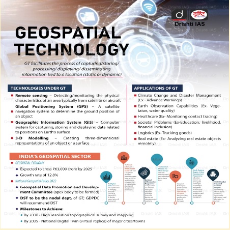
What is Geospatial Intelligence?
- Geospatial technology uses tools like GIS (Geographic Information System), GPS (Global Positioning System) and Remote Sensing for geographic mapping and analysis.
- These tools capture spatial information about objects, events and phenomena (indexed to their geographical location on earth, geotag). The location data may be Static or Dynamic.
- Static location data include position of a road, an earthquake event or malnutrition among children in a particular region while dynamic location data include data related to a moving vehicle or pedestrian, the spread of an infectious disease etc.
- The technology may be used to create intelligent maps to help identify spatial patterns in large volumes of data.
- The technology facilitates decision making based on the importance and priority of scarce resources.
What is the Significance of Geospatial Intelligence?
- Monitoring Tropical Cyclones:
- The National Hurricane Center relies on geospatial intelligence to monitor cyclone location, its formation, and trajectory.
- This information aids in resource allocation, issuing warnings, and managing evacuations.
- Search-and-Rescue Effort:
- After the 7.8 magnitude earthquake in Turkey and Syria (February 2023), geospatial intelligence identified damage and helped locate survivors.
- It facilitated the establishment of aid stations and emergency supply distribution.
- Environmental Monitoring:
- Predicting Climate-Related Events
- Temperature, precipitation, snowpack, and polar ice monitoring help anticipate and prepare for disturbances.
- This is crucial in addressing the increasing threats posed by climate change-induced extreme weather events.
- Predicting Climate-Related Events
- Military and Civilian Applications:
- Geospatial Intelligence in Border Management
- Satellite images play a vital role in reporting critical information, such as Russian ground forces' movements in the Ukrainian conflict and infiltration into India from Pakistan.
- Transportation and Logistics
- GPS technology and geospatial data enable efficient management of global supply chains.
- It provides governments and businesses with essential information on cargo movement.
- Geospatial Intelligence in Border Management
- Urban Planning and Autonomous Vehicles:
- Enhancing Urban Development
- High-resolution imagery aids city planners in designing safer and more efficient communities.
- Features like bicycle lanes and traffic directions are easily detectable.
- Role in Autonomous Vehicles
- Geospatial intelligence supports the development of autonomous vehicles by providing ground-level details.
- Safer and smarter transportation systems are being built.
- Enhancing Urban Development
- Digital Twins for Decision Making:
- Concept and Applications
- Digital twins are virtual replicas of real systems, used for modeling and predicting outcomes.
- They have proven effective in conflict settings for simulating weather and terrain.
- Concept and Applications
Why is there a Growing Need for Geospatial Intelligence?
- Addressing Future Challenges:
- Rising temperatures and urbanization increase the demand for geospatial intelligence.
- It aids in safeguarding communities and adapting to evolving conditions.
- Industry Growth
- The geospatial intelligence industry is projected to grow from $61 billion in 2020 to over $209 billion by 2030.
- It plays an essential role in shaping a safe and informed future.
- Precision Agriculture:
- Agriculture is becoming increasingly data-driven. Geospatial Intelligence helps farmers make informed decisions about crop management, soil quality, irrigation, and pest control.
- This becomes important for India, given around 18% of GDP is contributed by agriculture and 48% of the workforce is employed in it.
What are Government’s Initiatives to Promote Geospatial Technology in India?
- Government introduced the "Geospatial Information Regulation Bill, 2021." This bill aimed to regulate the acquisition, dissemination, and use of geospatial information in India.
- It proposed to set guidelines for mapping and geospatial data collection, with a focus on national security concerns.
- National Geospatial Policy, 2022 was launched to streamline the utilization of geospatial intelligence.
What are the Challenges in Geospatial Intelligence?
- There is no demand for geospatial services and products on a scale linked to India’s potential and size.
- This is mainly due to the lack of awareness among potential users in government and private.
- The other hurdle has been the lack of skilled manpower across the entire pyramid.
- The unavailability of foundation data, especially at high-resolution, is also a constraint.
- Essentially, foundation data can be seen as common data tables which are shared between multiple applications or processes which are supposed to create a sturdy foundation for good service automation and management.
- The lack of clarity on data sharing and collaboration prevents co-creation and asset maximization.
- There are still no ready-to-use solutions especially built to solve the problems of India.
Way Forward
- Establishing a Geo-Portal and Data Cloud: There is a need to establish a geo-portal to make all public-funded data accessible through data as a service model.
- It is important to inculcate the culture of data sharing, collaboration and co-creation.
- Generation of Foundation Data: This should include the data aggregation, data layers for cities, and data of natural resources.
- Bachelor’s Programme in Geospatial: India should start a bachelor’s programme in geospatial in India's premier institutions.
- These programmes will propel research and development efforts which are crucial for the development of technologies and solutions locally.
- Regulation: National organizations like Survey of India (SoI) and Indian Space Research Organisation (ISRO) should be entrusted with the responsibility of regulation and the projects related to the nation’s security and scientific significance.
- These organizations should not compete with entrepreneurs for government business as the latter remains in a disadvantageous position.
UPSC Civil Services Examination, Previous Year Question (PYQ)
Prelims
Q.1 In the context of space technology, what is “Bhuvan”, recently in the news? (2010)
(a) A mini satellite launched by ISRO for promoting the distance education in India
(b) The name given to the next Moon Impact Probe, for Chandrayaan-II
(c) A geoportal of ISRO with 3D imaging capabilities of India
(d) A space telescope developed by India
Ans: C
Mains
Q.1 What is India’s plan to have its own space station and how will it benefit our space programme? (2019)
Q.2 Discuss India’s achievements in the field of Space Science and Technology. How the application of this technology helped India in its socio-economic development? (2016)


