Biodiversity & Environment
International Day for Conservation of Mangrove Ecosystem
For Prelims: International Day for Conservation of Mangrove Ecosystem, Mangroves, Indian State Forest Report 2023, Sundarbans, MISHTI (Mangrove Initiative for Shoreline Habitats & Tangible Incomes), Sustainable Aquaculture In Mangrove Ecosystem (SAIME) initiative.
For Mains: Significance of Mangroves, Challenges Related to Mangroves in India
Why in News?
The International Day for Conservation of Mangrove Ecosystem (26th July) serves as a crucial reminder that these coastal guardians are vanishing 3-5 times faster than global forests.
- UNESCO and IUCN data reveals that global mangrove cover has halved since 1985, with 50% of remaining ecosystems now at risk of collapse.
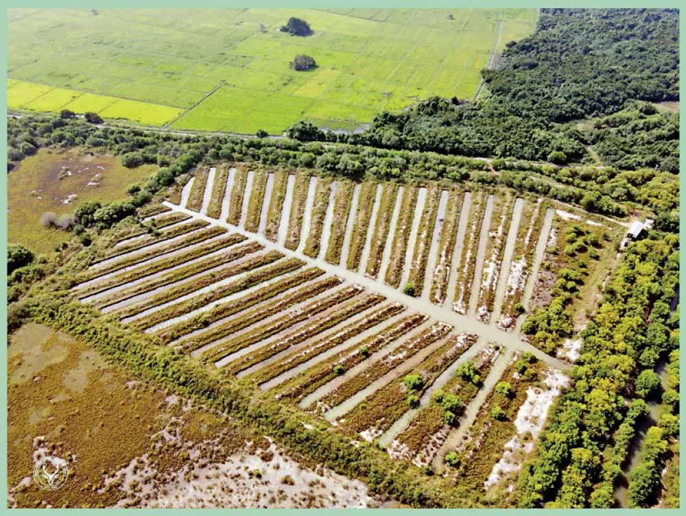
- The Tamil Nadu Forest Department held an awareness camp, highlighting mangrove biodiversity and the Fish Bone Channel Technique for ecological restoration.
International Day for the Conservation of the Mangrove Ecosystem
- Observed annually on 26th July, this day aims to raise awareness about the significance of mangrove ecosystems as unique, special, and vulnerable ecosystems, and to promote their sustainable management, conservation, and use.
- It was adopted by UNESCO’s General Conference in 2015 to highlight the vital ecological and socio-economic roles mangroves play in coastal protection, biodiversity support, and climate mitigation.
Fishbone Technique of Mangrove Restoration
- It is a mangrove restoration method for areas with poor tidal flow, involving a central "backbone" channel and angled feeder channels to divert water from creeks.
- Once salinity and water flow are suitable, mangrove seedlings are planted. It mimics natural creeks, enhances tidal reach, and supports natural regeneration with minimal effort.
What are Mangroves?
- About: Mangroves are specialized coastal ecosystems consisting of salt-tolerant (halophytic) trees and shrubs that flourish in the intertidal zones of tropical and subtropical regions.
- They are uniquely adapted to survive in saline, low-oxygen (anaerobic) environments with slow-moving waters and accumulated fine sediments.
- Common mangrove species include Red Mangrove, Grey Mangrove, and Rhizophora, which play a crucial role in coastal protection, carbon sequestration, and biodiversity conservation.
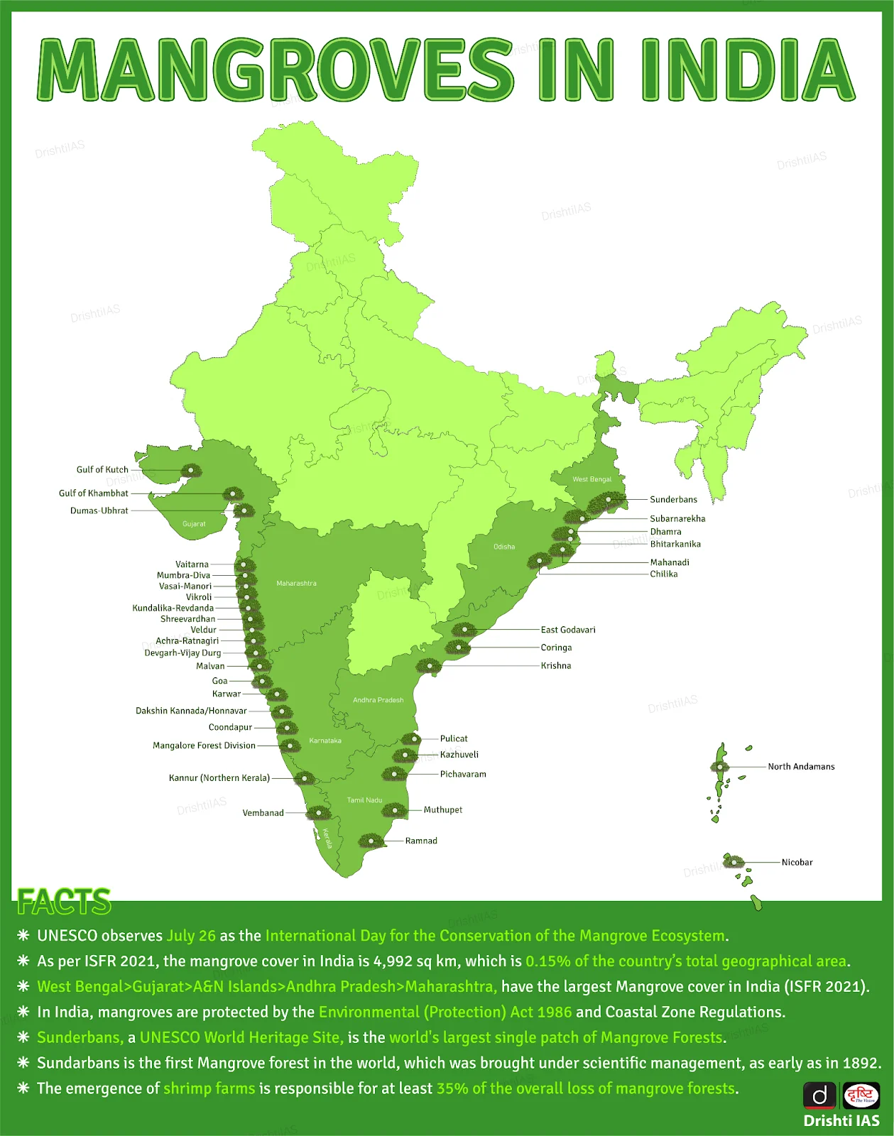
- Mangrove Cover in India: As per Indian State of Forest Report (ISFR) 2023, India's mangrove cover is about 4,992 sq. km, accounting for 0.15% of the country’s geographical area.
- West Bengal has the largest mangrove cover in India, followed by Gujarat in second place.
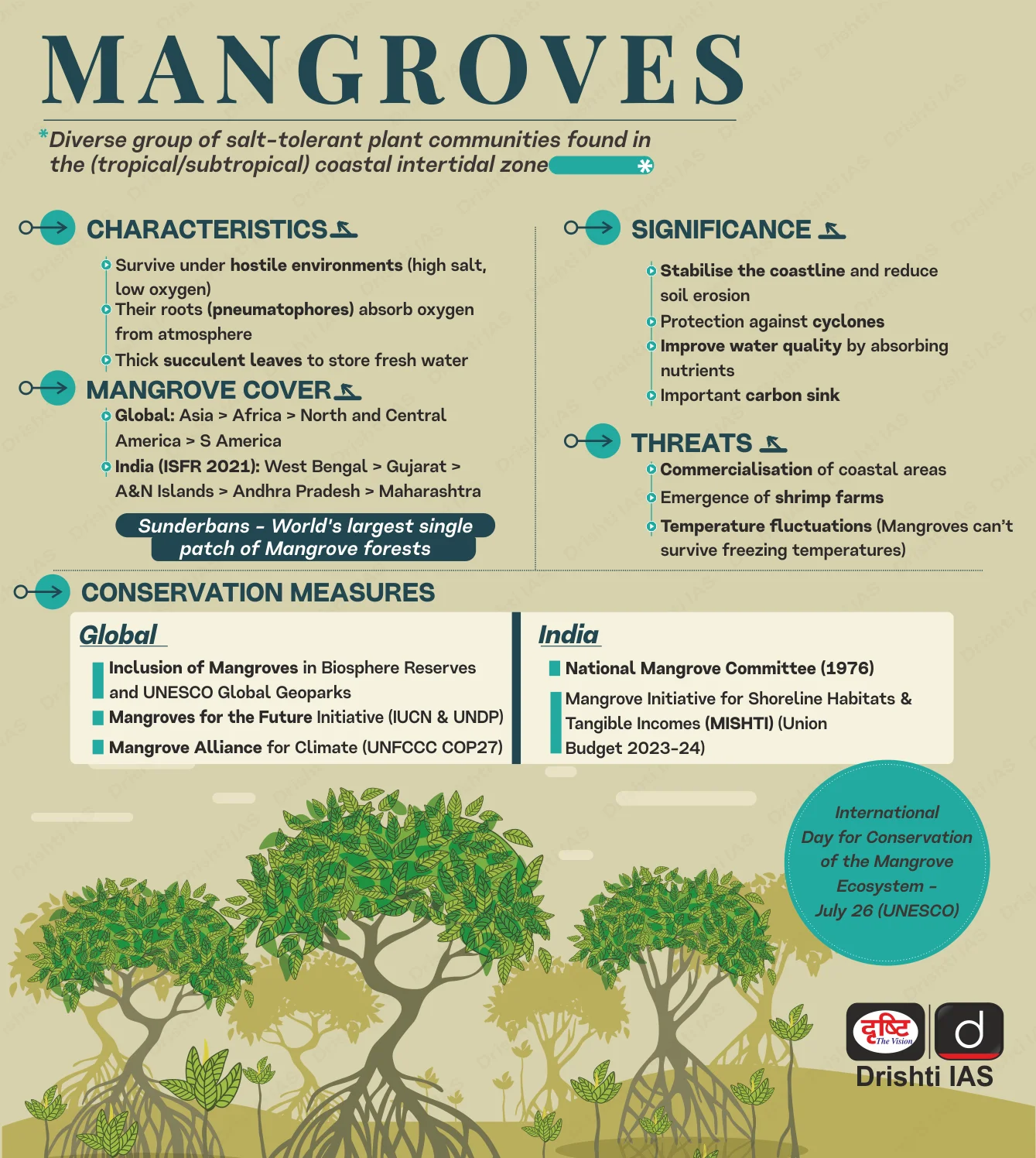
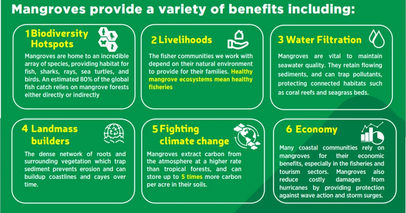
What is the Significance of Mangroves?
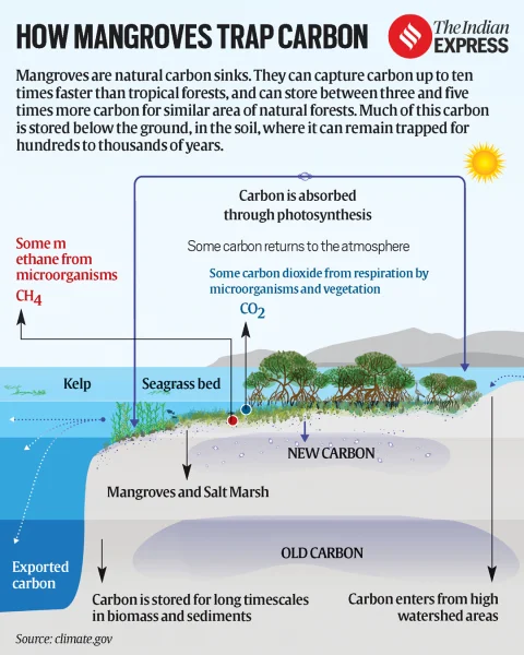
- Carbon Sequestration: Mangroves store around 394 tonnes of carbon per hectare, exceeding most terrestrial forests, due to anaerobic and saline soils that slow decomposition.
- According to UNESCO, 1 hectare can store up to 3,754 tonnes of carbon, equivalent to removing over 2,650 cars annually.
- They uniquely lock carbon in soil for millennia, making them critical for climate change mitigation.
- According to UNESCO, 1 hectare can store up to 3,754 tonnes of carbon, equivalent to removing over 2,650 cars annually.
- Coastal Protection: Mangroves serve as natural buffers against storm surges, tsunamis, and coastal erosion acting as "bio-shields".
- Their dense root systems absorb wave energy and stabilize shorelines, reducing wave energy by 5–35% and flood depths by 15–20%, with reductions exceeding 70% during extreme storms (100-year return period), playing a crucial role in disaster risk reduction and climate resilience of coastal regions.
- Biodiversity Hotspots: Mangroves support diverse terrestrial and aquatic species across habitats like mudflats and aerial roots.
- India’s mangroves host 5,746 species (84% animals) across 21 phyla, the highest globally, including Bengal tigers, estuarine crocodiles, Indian pythons, and 260+ bird species.
- They serve as nurseries for marine life and support one-third of wild fish landings in Southeast Asia.
- Economic Significance, Food Security & Livelihood Support: Mangroves are vital to coastal economies, supporting fishing, honey collection, boating, and non-timber forest produce.
- They nurture nearly 800 billion aquatic species annually, providing nutrient-rich seafood (rich in protein, omega-3s, vitamins D & B12, iron, and zinc) and sustaining livelihoods through the blue economy.
- Mangroves also offer eco-tourism potential and play a key role in food security and human wellbeing in coastal regions.
Sundarbans: Ecological Significance, Threats & Conservation Efforts
- The Sundarbans, the world's largest mangrove forest in the Ganges-Brahmaputra-Meghna delta, holds immense ecological value as a UNESCO Biosphere Reserve and Ramsar site.
- It is a biodiversity hotspot, home to Royal Bengal Tiger, Irrawaddy and Ganges dolphins, saltwater crocodiles and crucial for coastal protection against cyclones and carbon sequestration.
- However, it faces severe threats from climate change (sea-level rise, cyclones), coastal erosion, and unsustainable livelihoods.
- Conservation efforts include increased government funding for mangrove plantations, Indo-Bangladesh climate-smart village initiatives, and community-led Joint Mangrove Management for sustainable preservation.
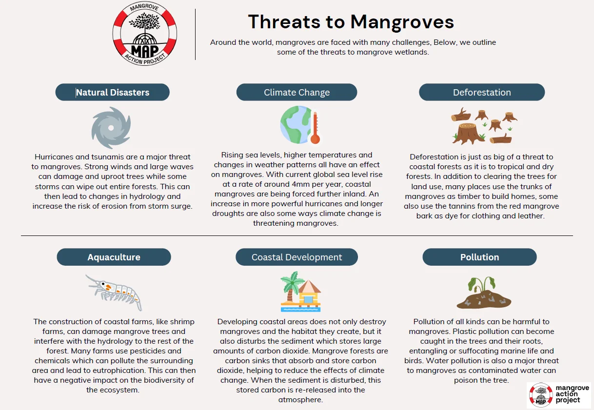
What are the Major Threats to Mangroves?
- Land Conversion for Agriculture: According to the "State of the World's Mangroves 2024" report, extensive conversion of mangrove land for aquaculture (26%), oil palm plantations, and rice cultivation (43%) is a major driver of loss.
- Urbanisation, infrastructure projects, and coastal tourism also lead to large-scale deforestation and fragmentation of mangrove ecosystems.
- Pollution & Industrial Activities: Oil spills, industrial effluents, and plastic waste degrade water quality and hinder mangrove regeneration.
- Cases like the Niger Delta highlight how oil contamination leads to long-term ecological damage. Timber extraction and charcoal production also contribute to degradation.
- Climate Change & Sea-Level Rise: Rising sea levels, increased frequency of cyclones, and coastal erosion due to climate change pose existential threats. As per the IUCN Red List of Ecosystems, climate change threatens 33% of mangrove ecosystems.
- Invasive Species & Biodiversity Loss: Species like Prosopis juliflora, found in Tamil Nadu and Sri Lanka, disrupt native mangrove habitats by altering soil salinity, reducing freshwater availability, and preventing natural regeneration, thereby threatening local biodiversity.
Key Initiatives Related to Mangroves Conservation
- Mangrove Alliance for Climate (MAC)
- Mangroves for the Future (MFF)
- MISHTI (Mangrove Initiative for Shoreline Habitats & Tangible Incomes)
- Sustainable Aquaculture In Mangrove Ecosystem (SAIME) initiative
- Coastal Regulation Zone (CRZ) Rules
- CAMPA Funds & National Coastal Mission
- Vana Samrakshana Samitis (Andhra Pradesh)
- Green Tamil Nadu Mission
Way Forward
- Strengthen Legal Framework: Enforce stricter laws to prevent deforestation, pollution, and unsustainable coastal development.
- Community Participation: Involve local communities through sustainable livelihoods and initiatives like “adopt a mangrove” for conservation and restoration.
- Research & Technology: Promote phytoremediation, medicinal research, and use of drones and AI for real-time monitoring and protection.
- Bio-Restoration: Rehabilitate degraded areas using bio-restoration and ensure species diversity to build climate resilience.
- Sustainable Development: Encourage eco-friendly coastal infrastructure, regulate aquaculture, and integrate mangroves into urban planning.
- International Collaboration: Leverage global platforms like the Ramsar Convention and Blue Carbon Initiative for coordinated conservation efforts.
World Nature Conservation Day (28th July)
- Celebrated annually, World Nature Conservation Day underscores the critical need for environmental protection and biodiversity conservation.
- It reinforces commitments under international environmental frameworks such as the UNFCCC, CBD, and SDGs (especially Goals 13, 14, and 15).
- The observance complements India’s LiFE (Lifestyle for Environment) initiative, advocating sustainable habits like water conservation, waste reduction, and eco-friendly mobility.
|
Drishti Mains Question: Discuss the ecological and economic significance of mangroves in the Indian context. Propose a comprehensive strategy for their conservation and sustainable utilisation. |
UPSC Civil Services Examination Previous Year Question (PYQ)
Prelims:
Q. Which one of the following regions of India has a combination of mangrove forest, evergreen forest and deciduous forest? (2015)
(a) North Coastal Andhra Pradesh
(b) South-West Bengal
(c) Southern Saurashtra
(d) Andaman and Nicobar Islands
Ans: (d)
Mains:
Q. Discuss the causes of depletion of mangroves and explain their importance in maintaining coastal ecology. (2019)
Social Justice
State of Food Security and Nutrition in the World 2025
For Prelims: Food and Agriculture Organization, Stunting, Anaemia, SDG 2, Millet, Anaemia Mukt Bharat
For Mains: Food and Nutrition Security in India, Challenges in Achieving SDG 2 (Zero Hunger), Obesity as a Public Health Concern in India
Why in News?
The State of Food Security and Nutrition in the World (SOFI) 2025 report, shows global hunger dipped to 673 million, but India still has the highest number of wasted children under five.
Note: SOFI is jointly produced by Food and Agriculture Organization (FAO), the International Fund for Agricultural Development (IFAD), the United Nations International Children's Emergency Fund (UNICEF), the UN World Food Programme (WFP), and the World Health Organization (WHO).
What is the Current State of Global Hunger and Food Insecurity as Highlighted in SOFI 2025?
Global
- Hunger Trends: In 2024, 8.2% of the world population (673 million) experienced hunger, down from 8.5% in 2023. Hunger remains above pre- Covid-19 levels, indicating incomplete recovery.
- By 2030, around 512 million people may remain chronically undernourished, with nearly 60% in Africa. Achieving SDG 2 (Zero Hunger) will need major shifts in policy, funding, and food systems.
- Food Insecurity: Globally, 2.3 billion people are moderately or severely food insecure, representing a significant portion of the world’s population.
- The pandemic and the Ukraine war worsened global food price inflation, pushing up the cost of a healthy diet through 2023 and 2024. Yet, the number of people unable to afford such a diet fell from 2.76 billion in 2019 to 2.60 billion in 2024.
- Regional Breakdown: Asia accounted for the highest number of undernourished people at 323 million, followed by Africa (307 million) and Latin America and the Caribbean (34 million).
India’s Nutritional Paradox
- Undernourishment and Diet Affordability: About 12% of India’s population is undernourished (172 million people). While this is an improvement from 243 million in 2006, India still ranks 48th globally and 7th highest in Asia for undernourishment.
- In India, 42.9% of people cannot afford a healthy diet, as food costs rose from USD 2.77 (2017) to USD 4.07 (2024) in Purchasing Power Parity (PPP) terms.
- Double Burden of Malnutrition: Overweight children increased from 2.7 million (2012) to 4.2 million (2024).
- Adult obesity rose from 33.6 million to 71.4 million, highlighting rising overnutrition alongside undernutrition.
- Child Wasting and Stunting: India has the world’s highest child wasting rate (18.7%) with over 21 million children.
- 37.4 million children under five are stunted, showing chronic undernutrition.
- Anaemia in Women: Over 53.7% of women aged 15–49 in India suffer from anaemia (203 million in total). India ranks 4th globally in anemia prevalence, behind Gabon, Mali, and Mauritania.
Malnutrition in Children
|
Indicator |
Definition |
Consequences and Implications |
|
Stunting |
Height-for-age < -2 Standard Deviation (SD) of the WHO Child Growth Standards median. |
Delayed mental development and poor school performance. |
|
Wasting |
Weight-for-height < -2 SD of the WHO Child Growth Standards median. |
Impairs the immune system, leading to increased severity and duration of diseases. It is an urgent sign of severe malnutrition. |
|
Overweight |
Weight-for-height > +2 SD of the WHO Child Growth Standards median. |
Increased risk of non-communicable diseases (NCDs) like cardiovascular diseases, diabetes, musculoskeletal disorders (osteoporosis), and certain cancers (endometrial, breast, colon). |
|
Underweight |
Weight-for-age <-2 SD of the WHO Child Growth Standards median. |
Children who are severely underweight are at greater risk of death. Impaired growth and development and delayed cognitive abilities. |
What are the Causes of India’s Nutrition Paradox?
- Persistent Poverty and Inequality: Malnutrition and food insecurity remain concentrated among socio-economically marginalized communities, especially in rural and tribal areas.
- Inadequate Dietary Diversity: Lack of access to fruits, vegetables, and protein-rich foods despite calorie sufficiency leads to hidden hunger (micronutrient deficiency).
- High Food Prices: Inflation in nutrient-dense foods (e.g., milk, pulses, fruits) makes healthy diets financially inaccessible for a large population.
- Health Service Gaps: Antenatal care, anaemia screening, and nutrition counselling remain inadequate across primary health systems.
- Nutrition Transition: Urbanization and income growth have increased consumption of processed foods, resulting in higher rates of childhood and adult obesity.
India’s Schemes Related to Food and Nutritional Security
- Public Distribution System (PDS): As of 2025, India’s PDS covers over 80 crore people with 99.6% Fair Price Shops (FPSs) automation ensuring transparent foodgrain delivery.
- PM POSHAN: Provides mid-day meals to school children, it aims to improve nutrition and boost school attendance.
- Pradhan Mantri Garib Kalyan Anna Yojana (PMGKAY): Offers 5 kg of free foodgrains per month to 81.35 crore people as of 2025, it is extended till 2029 to ensure nationwide food security.
- POSHAN Abhiyaan: Targets malnutrition in women, children, and adolescents with over 10 crore beneficiaries by 2024.
- PM Formalization of Micro Food Processing Enterprises Scheme (PMFME): Supports micro food enterprises. Over 54,000 units set up and 1.88 lakh jobs created by 2023-24.
- Price Stabilization Efforts: Buffer stocks and subsidized Bharat food products keep essentials like onions, atta, dal, and rice affordable.
What Strategies are Needed to Tackle India’s Nutritional Paradox?
- Invest in Local Food Systems: Support farmer producer organizations (FPOs) and local food processing units under schemes like PMFME, and strengthen agricultural market information systems to manage price fluctuations.
- Use targeted fiscal steps like stronger social safety nets, while aligning fiscal and monetary policies for stability.
- Encourage kitchen gardens, millet promotion (Shree Anna), and region-specific crops to improve dietary diversity.
- Combat Anaemia Among Women: Expand Anaemia Mukt Bharat by providing iron‑folic acid supplementation, deworming, and therapeutic dosing tailored to individual needs.
- Improve Dietary Diversity and Protein Access: India’s diet is still heavily cereal-based. To tackle child malnutrition protein-rich foods like eggs and dairy should be regularly included in mid-day meals and child nutrition programs.
- Enhance PM Poshan Scheme and POSHAN Abhiyaan to address both macro and micronutrient deficiencies.
- Accelerate the implementation of the "One Nation, One Ration Card" scheme to ensure food access for migrant workers.
- Monitor Obesity and Promote Healthy Lifestyles: India needs a ‘Suposhan Abhiyan’ to address both undernutrition and rising obesity by encouraging mindful eating.
- Tax junk food, subsidize healthy items, and schools must teach nutrition (like using Sugar Boards).
|
Drishti Mains Question: Discuss the significance of dietary diversity in tackling hidden hunger in India. |
UPSC Civil Services Examination, Previous Year Question (PYQ)
Prelims:
Q. Which of the following is/are the indicator/indicators used by IFPRI to compute the Global Hunger Index Report? (2016)
- Undernourishment
- Child stunting
- Child mortality
Select the correct answer using the code given below:
(a) 1 only
(b) 2 and 3 only
(c) 1, 2 and 3
(d) 1 and 3 only
Ans: (c)
Mains:
Q. Can the vicious cycle of genderinequality, poverty andmalnutrition be broken through microfinancing of women SHGs? Explain with examples. (2021)
Q. Food Security Bill is expected to eliminate hunger and malnutrition in India. Critically discuss various apprehensions in its effective implementation along with the concerns it has generated in WTO. (2013)
International Relations
China’s Mega Dam on Brahmaputra
Prelims: Yarlung Zangbo River, River Ganga, Brahmaputra River.
Mains: India-China Relations, China’s Megadam Project on Brahmaputra, Concerns over China’s Building New Dam in Tibet..
Why in News?
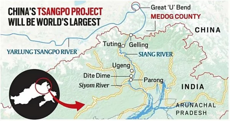
China is building a 60,000 MW hydropower project on the Yarlung Zangbo River (known as the Brahmaputra in India and Jamuna in Bangladesh) in Tibet, near Gelling in Arunachal Pradesh.
- Announced in 2021, the project involves 5 cascade dams and is expected to be completed by the 2030s.
- It will be 3 times more powerful than the Three Gorges Dam, the world’s largest hydropower station.
What are the Key Concerns of India over China’s Mega-Dam on Brahmaputra?
- Ecological and Seismic Risks: Situated in the seismically active Himalayan zone, where the Indian and Eurasian plates meet, the region is highly prone to earthquakes, landslides, and flash floods.
- The project threatens large-scale displacement, similar to the Three Gorges Dam, which displaced over 1.3 million people.
- The dam could act as a “water bomb” and China may weaponise the dam to exert geopolitical pressure on India, particularly after India’s suspension of the Indus Waters Treaty following the Pahalgam terror attack.
- Hydrological & Environmental Impact: The Brahmaputra is vital for agriculture, livelihoods, and biodiversity.
- Sudden water release or diversion could devastate ecosystems, particularly in tribal regions like the Siang belt, home to the Adi tribe.
- Loss of Traditional Knowledge: Artificial flow regulation undermines indigenous flood management systems, increasing vulnerability to climate extremes and displacing centuries-old practices.
- Legal & Diplomatic Gaps: China's unilateral actions disregard India’s riparian rights, as China is not a signatory to any international water-sharing treaty.
- Threat to Regional Water & Food Security: The dam could impact irrigation, hydropower, and flood regulation in India’s northeastern states, threatening water, food, and energy security.
What is India’s Response on China’s Construction of Dams on Brahmaputra?
- Siang Upper Multipurpose Project: India plans a around 11.2 GW hydropower project in Arunachal Pradesh as a strategic and water-security response. It will regulate floods from upstream Chinese dams.
- The project involves local tribal engagement, especially the Adi community.
- Monitoring & River Contribution: Though India has only around 34% of the basin, it contributes over 80% of the Brahmaputra’s flow due to 2,371 mm rainfall and snowmelt, unlike Tibet’s 300 mm.
- Indian tributaries, especially in Arunachal Pradesh and Assam, contribute 30% of water resources and 41% of hydropower potential, with Arunachal Pradesh playing a key role despite challenges.
- Proposed River Linking Projects:
- Manas–Sankosh–Teesta–Ganga Link: Aims to connect the Manas (a Brahmaputra tributary) to the Ganga via Sankosh and Teesta.
- Jogighopa–Teesta–Farakka Link: Proposes linking the Brahmaputra at Jogighopa Barrage to the Ganga at Farakka.
- Diplomatic Dialogue & CBMs: India raised concerns with China regarding Chinese infrastructure and its impact on downstream flow.
- Bilateral talks held in Beijing (March 2025) addressed water-sharing and border disengagement.
- Confidence-Building Measures (CBM) include resumption of tourist visas and Kailash Mansarovar Yatra after 5 years.
- Bilateral talks held in Beijing (March 2025) addressed water-sharing and border disengagement.
What Measures can India take to Address Risk from China’s Brahmaputra Dams?
- Accelerate Strategic Water Infrastructure: India must fast-track projects like the Upper Siang Hydropower Project in Arunachal Pradesh, featuring a 300-metre-high dam capable of absorbing upstream flow variations.
- Parallelly, expanding storage capacity across the Brahmaputra basin will help mitigate risks of flooding and seasonal water stress arising from Chinese interventions.
- Enhance Scientific & Institutional Preparedness: Conduct scientific assessment of the ecological and geopolitical risks posed by China’s dam-building spree.
- Strengthening institutional capabilities for real-time data modelling and predictive analytics, as highlighted by Institute for Defence Studies and Analyses (IDSA) will enable timely responses to potential water weaponisation.
- Implement Interlinking & Channel Diversion Plans: India should operationalise National Water Development Agency (NWDA)’s interlinking plans, connecting Brahmaputra tributaries to the Ganga basin to redirect excess water to drought-prone regions.
- Additionally, inland channel systems can serve as buffers to manage monsoon overflow and reduce flood vulnerability.
- Strengthen Diplomacy & Regional Cooperation: China has ceased sharing crucial hydrological data with India since 2022.
- The Brahmaputra MoU, in place since 2002, expired in June 2023, and the Sutlej River MoU, from 2005, expired in November 2020 and has not been renewed since.
- India should push for diplomatic channels with China to obtain detailed real-time hydrological and project data to assess downstream impact on a continuous basis.
- Also, developing regional coordination with Bhutan, Bangladesh, and Myanmar is vital for joint disaster preparedness, early warning systems, and collective transboundary water governance.
The Key Facts Related to Brahmaputra River System
- Origin & Course: The Brahmaputra River originates from the Chemayungdung Glacier in the Kailash Range near Mansarovar Lake in Tibet, where it is called the Yarlung Tsangpo.
- It enters India through Arunachal Pradesh as the Siang (or Dihang), flows through Assam, and enters Bangladesh as the Jamuna after merging with the Teesta River. It then joins the Ganga (Padma) near Goalundo Ghat and finally merges with the Meghna River, draining into the Bay of Bengal.
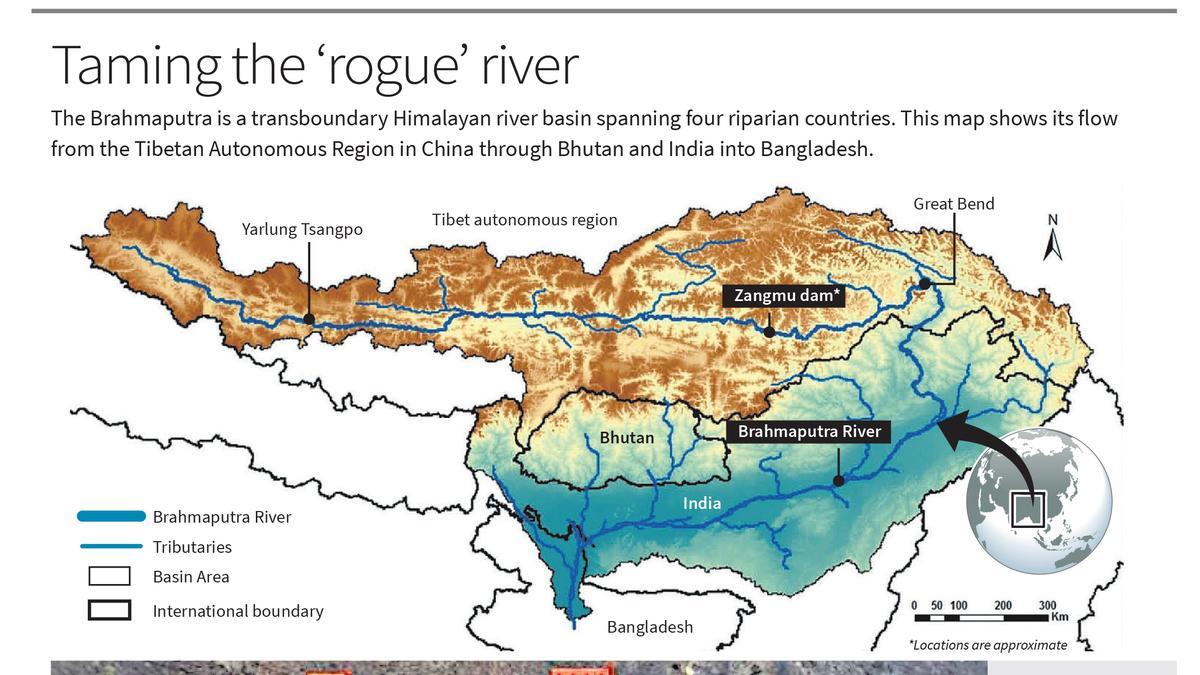
- Basin: The Brahmaputra River Basin spans Tibet (China), Bhutan, India, and Bangladesh. In India, its catchment area covers Arunachal Pradesh, Assam, West Bengal, Meghalaya, Nagaland, and Sikkim.
- The basin is bounded by the Himalayas to the north and west, the Patkai Hills to the east, and the Assam Hills to the south.
- The Brahmaputra is 2,900 km long, with only 916 km flowing through India. (The Ganges is the longest river entirely within India).
- Major Tributaries:
- Right Bank: Lohit, Dibang, Subansiri, Jiabharali, Dhansiri, Manas, Torsa, Sankosh, Teesta
- Left Bank: Burhidihing, Desang, Dikhow, Dhansiri (south), Kopili
- Ecological & Hydrological Significance: The Brahmaputra Basin holds over 30% of India’s total water resources and contributes around 41% of the country’s hydropower potential.
- It supports critical biodiversity zones, including Kaziranga and Manas National Parks, and rich ecosystems.
- The basin is also characterized by deciduous forests in the valley and surrounding hills, making it vital for both ecological balance and sustainable development.
- It supports critical biodiversity zones, including Kaziranga and Manas National Parks, and rich ecosystems.
- Unique Features: Majuli, the world’s largest river island, and Umananda, the smallest river island, are both located on the Brahmaputra River in Assam, highlighting its unique fluvial dynamics.
|
Read More: Transboundary Rivers of India Read More: Hydro Electric Projects in Brahmaputra Basin (India) |
UPSC Civil Services Examination Previous Year Question (PYQ)
Prelims:
Q. With reference to river Teesta, consider the following statements: (2017)
- The source of river Teesta is the same as that of Brahmaputra but it flows through Sikkim.
- River Rangeet originates in Sikkim and it is a tributary of river Teesta.
- River Teesta flows into Bay of Bengal on the border of India and Bangladesh.
Which of the statements given above is/are correct?
(a) 1 and 3 only
(b) 2 only
(c) 2 and 3 only
(d) 1, 2 and 3
Ans: (b)
Mains:
Q. “China is using its economic relations and positive trade surplus as tools to develop potential military power status in Asia”. In the light of this statement, discuss its impact on India as her neighbour. (2017)
Important Facts For Prelims
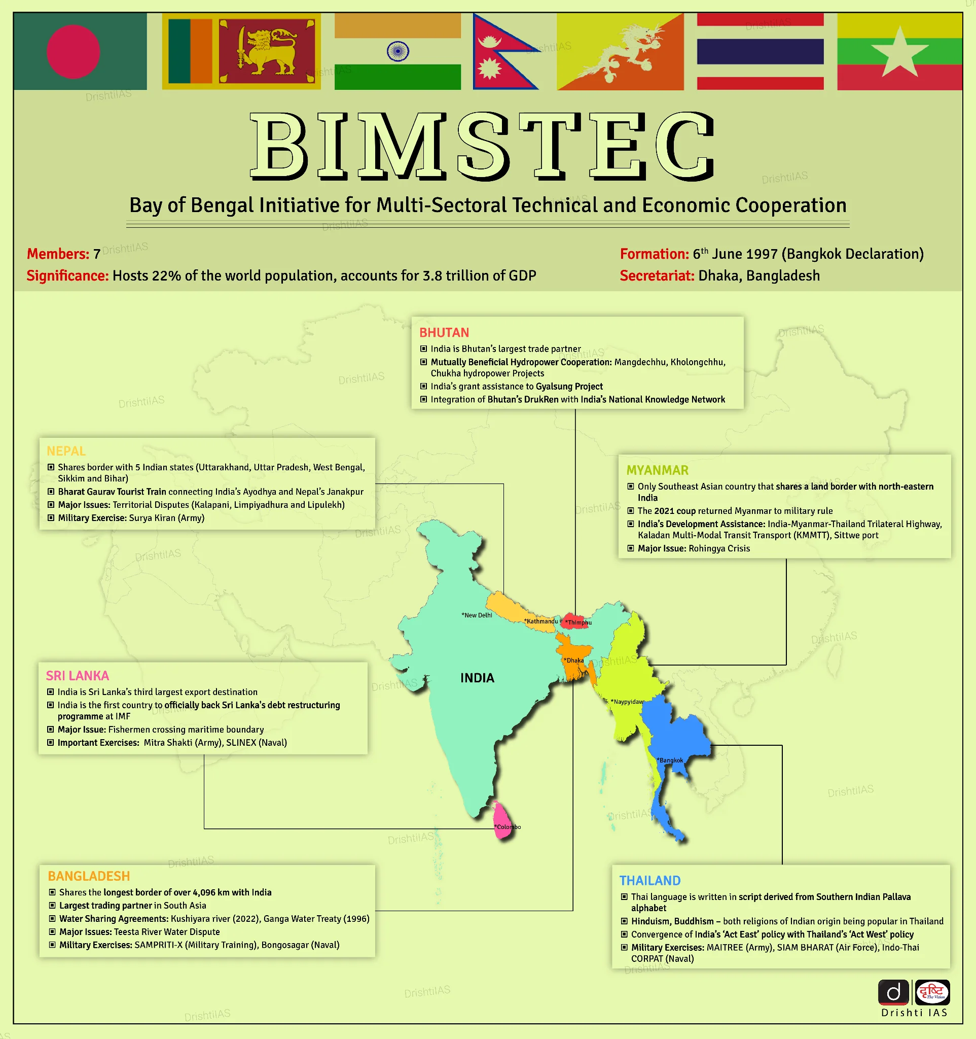
India Hosts 2nd BIMSTEC Ports Conclave
Why in News?
India hosted the 2nd BIMSTEC (Bay of Bengal Initiative for Multi-Sectoral Technical and Economic Cooperation) Ports Conclave in Visakhapatnam, to strengthen maritime connectivity, and sustainable development in the region.
BIMSTEC Ports Conclave
- Theme 2025: "Navigating the Future: Blue Economy, Innovation and Sustainable Partnerships.”
- Significance for India: Boosts India's leadership in Bay of Bengal maritime cooperation, and aligns with Sagarmala goals of port-led growth and connectivity
- It enhances India’s Indo-Pacific role through stronger BIMSTEC ties.
What are the Key Outcomes of 2nd BIMSTEC Ports Conclave?
- Push to Implement AMTC: Member countries were urged to ratify and implement the BIMSTEC Agreement on Maritime Transport Cooperation (AMTC), signed during the 6th BIMSTEC Summit (2025, Bangkok).
- The AMTC aims to boost port-led growth, enhance maritime trade and tourism, and promote skill development across BIMSTEC nations.
- Kaladan Corridor: The Kaladan Multi-Modal Transit Transport Project (KMTTP) was recognized as a strategic corridor linking India’s Northeast with the Bay of Bengal, central to India’s Act East and Neighbourhood First policies.
- The KMTTP, jointly developed by India and Myanmar, enables efficient cargo movement from India’s eastern ports to the Northeast via Myanmar.
- It includes a waterway on Myanmar’s Kaladan River from Sittwe to Paletwa, and a road from Paletwa to Zorinpui on the India-Myanmar border in Mizoram.
- KMTTP helps bypass the narrow Siliguri Corridor (or “Chicken’s Neck”), reducing transport costs and time.
- The KMTTP, jointly developed by India and Myanmar, enables efficient cargo movement from India’s eastern ports to the Northeast via Myanmar.
- BIMSTEC Sustainable Maritime Transport Centre (Mumbai): It will be launched under the Indian Ocean Centre of Excellence for Sustainable Maritime Transport (IOCE-SMarT), which will lead efforts in policy harmonisation, green transition, and digital innovation in the maritime sector.
- Cruise Tourism Potential: Conclave emphasised eco-sensitive cruise routes, and Public-Private Partnerships (PPPs) led cruise terminals to position the Bay of Bengal as a premier sustainable tourism corridor.
What is BIMSTEC?
- About: BIMSTEC is a regional organization established on 6th June 1997 through the Bangkok Declaration.
- Purpose: Promote economic and technical cooperation among Bay of Bengal countries.
- Evolution: Originally started as BIST-EC (Bangladesh, India, Sri Lanka, Thailand Economic Cooperation), the grouping became BIMST-EC after Myanmar joined in 1997. It was renamed BIMSTEC in 2004 following the inclusion of Nepal and Bhutan.
- At the 3rd BIMSTEC Summit in 2014, the BIMSTEC Secretariat was established in Dhaka, Bangladesh.
- Sectors of Cooperation: Initially six (trade, technology, energy, transport, tourism, and fisheries). In 2008, it expanded to include agriculture, public health, counter-terrorism, environment, and climate change.
- To improve coordination, the sectors were reorganized in 2021, with each member state taking the lead in specific areas.
- India leads the Security pillar in BIMSTEC, covering counter-terrorism, transnational crime, disaster management, and energy.
UPSC Civil Services Examination Previous Year Question (PYQ)
Prelims
Q. Consider the following statements in respect of BIMSTEC: (2025)
I. It is a regional organization consisting of seven member States till January 2025.
II. It came into existence with the signing of the Dhaka Declaration, 1999.
III. Bangladesh, India, Sri Lanka, Thailand and Nepal are founding member States of BIMSTEC.
IV. In BIMSTEC, the subsector of 'tourism' is being led by India.
Which of the statements given above is/are correct?
A. I and II
B. II and III
C. I and IV
D. I only
Ans: (D)
Facts for UPSC Mains
Parametric Insurance for Disaster Risk Reduction
Why in News?
Himachal Pradesh faced over 20 flash floods along with landslides and cloudbursts, highlighting the unpredictability of extreme weather events due to climate change and rising disaster risks in India.
- Between 2019 and 2023, India suffered over $56 billion in losses due to weather-related disasters. In this context, parametric insurance is emerging as a quick and transparent tool for managing climate-related risks.
What are the Key Statistics Related to Rising Disaster Risks in India?
- India recorded 764 major natural disasters since 1900, with nearly 50% occurring after 2000, reflecting increased climate volatility.
- As per World Bank, India's drought-prone area has increased by 57% since 1997, while instances of heavy rainfall have risen by almost 85% since 2012.
- The Reserve Bank of India (RBI) estimates that up to 4.5% of India's GDP could be at risk by 2030, due to lost labour hours from extreme heat and humidity.
- India’s climate-related losses accounted for almost 25% of all such losses in the Asia-Pacific during this period — the highest in South Asia.
- Considering the growing frequency, intensity, and economic burden of such disasters, there is an urgent need to institutionalize innovative insurance solutions.
What is Parametric Insurance?
- Definition: A type of insurance where payouts are triggered automatically when predefined parameters (e.g., rainfall, temperature, seismic activity) cross a set threshold.
- Unlike traditional insurance that requires physical loss assessment, parametric insurance provides payouts based on predefined weather triggers (rainfall or wind speed), enabling faster, hassle-free compensation, especially useful during large-scale disasters.
- Related Case Studies:
- Rajasthan and Uttar Pradesh use a water balance index to protect women small-holder farmers from drought. Automatic loan support was provided.
- Nagaland became the first state in India to purchase a multi-year parametric cover using disaster mitigation funds, for landslides and extreme rainfall.
- Globally, countries in Africa, the Pacific Islands, and U.K. have used parametric products to cover everything from droughts and floods to cyclone winds and flood depths
How Parametric Insurance can be Integrated in Disaster Risk Reduction Framework?
- Integrate Parametric Models into State Disaster Plans: Encourage states to adopt “Smart Cover for Smart States” using parametric policies under State Disaster Response Fund/ Disaster Management Fund.
- Expand Sector-Specific Coverage: Scale up insurance in agriculture (that can help farmers in drought prone as well as flood prone areas), renewable energy, transport, and MSMEs to prevent cascading economic shocks.
- Develop Climate-Linked Microfinance Products: Financial institutions can design policies where loans are auto-covered during weather shocks.
- Promotes “Insurance that thinks ahead” for vulnerable borrowers like smallholder farmers.
- Promote Public-Private Partnerships: Collaborate with reinsurers, agri-tech firms, and startups for better models and outreach.
Conclusion:
Parametric insurance transforms disaster response from reactive compensation to proactive protection building upon Sendai Framework for Disaster Risk Reduction, ensuring both financial resilience and climate justice in a warming world.
Related Keywords for Mains:
- Climate Change & Disaster Resilience
- “Predictable Unpredictability”: Climate extremes are known risks, not black swans.
- “From Rescue to Resilience”: Shift from reactive relief to proactive preparedness.
- “Mitigation is investment, not expense”: Climate spending as economic prudence.
- Parametric Insurance & Climate Finance
- “From Loss Assessment to Loss Anticipation”: Forecast-based financial security.
- “Liquidity is the first relief”: Speedy financial flow post-disaster ensures recovery.
UPSC Civil Services Examination Previous Year Question (PYQ)
Mains:
Q. Discuss the recent measures initiated in disaster management by the Government of India departing from the earlier reactive approach. (2020)
Q. Vulnerability is an essential element for defining disaster impacts and its threat to people. How and in what ways can vulnerability to disasters be characterized? Discuss different types of vulnerability with reference to disasters. (2019)
Q. Describe various measures taken in India for Disaster Risk Reduction (DRR) before and after signing ‘Sendai Framework for DRR (2015-30)’. How is this framework different from ‘Hyogo Framework for Action, 2005’? (2018)
Rapid Fire
Pralay Missile
The Defence Research & Development Organisation (DRDO) conducted two consecutive successful test flights of the Pralay missile, from Dr APJ Abdul Kalam Island off Odisha’s coast.
- Pralay is an indigenously developed solid propellant quasi-ballistic missile with advanced guidance and navigation systems for pinpoint accuracy.
- Pralay is a short-range surface-to-surface missile, with a payload capacity of 500 to 1,000 kg, and has a range of 150 to 500 km.
- The missile can carry multiple types of warheads and strike varied targets, enhancing flexibility and deterrence.
- Pralay was developed by Research Centre Imarat (Hyderabad) with major support from Pune-based DRDO labs.
- Quasi-ballistic missiles differ from traditional ballistic missiles by flying at lower altitudes and performing in-flight maneuvers, making them harder to intercept.
| Read more: Pralay Missile |
Rapid Fire
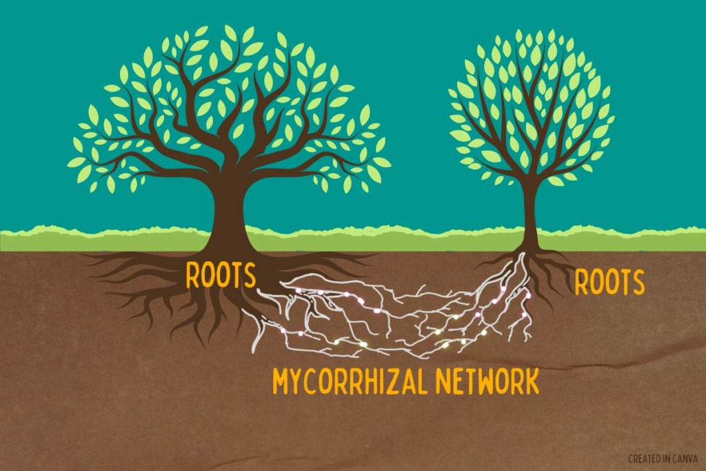
SPUN Atlas Highlights Gaps in Mycorrhizal Fungi Conservation
The Society for the Protection of Underground Networks (SPUN) has launched the Underground Atlas, which shows that over 90% of mycorrhizal fungi hotspots lie outside protected areas, despite their key role in nutrient cycling and carbon sequestration.
- Role in Ecosystem: Mycorrhizal fungi form symbiotic relationships with over 80% of plants, aiding nutrient absorption like phosphorus and playing a key role in carbon sequestration by utilizing CO2 from plant roots.
- They store around 13 billion tonnes of CO2 annually, or one-third of global fossil fuel emissions.
- Types of Mycorrhizal fungi:
- AM (Arbuscular Mycorrhizal) fungi: They penetrate root cells, common in crops and grasses.
- Hotspots: Brazilian Cerrado, Southeast Asia, West Africa
- EcM (Ectomycorrhizal) fungi: They wrap around roots, common in forest trees like oak and pine.
- Hotspots: Canada, Siberia, Central Europe, Western US.
- AM (Arbuscular Mycorrhizal) fungi: They penetrate root cells, common in crops and grasses.
- Recognising the ecological significance of fungi and other soil organisms, the FAO launched the Global Soil Biodiversity Observatory (GLOBSOB) at COP15 of the Convention on Biological Diversity in Canada, a global effort to monitor, protect, and integrate soil life into environmental policy.
| Read More: Flora Fauna and 'Funga' |
Rapid Fire
Paithani Sarees
The Prime Minister of India highlighted the cultural significance and traditional craftsmanship of Paithani sarees ( known as Mahavastra of the state of Maharashtra).
- Paithani sarees originated in Paithan, Chhatrapati Sambhajinagar (Maharashtra) around the 6th century B.C.
- Paithani sarees are handwoven silk sarees with rich zari (gold or silver thread) work, known for vibrant pallus and motifs like peacocks and lotuses, inspired by Ajanta and Ellora caves art and mythology.
- Recognised for their uniqueness and cultural value, Paithani Sarees and Fabrics have been granted Geographical Indication (GI) tag in 2010.
- The craft has a 2000-year-old legacy, dating back to the Satavahana era, when Paithan was a silk export hub to the Roman Empire.
- Dynasties like the Vakatakas, Rashtrakutas, Tughlaqs, Mughals, and Marathas supported its growth.
- The other GI-tagged saree from Maharashtra is Karvathi Kati Tussar Silk Saree, handwoven exclusively in the Vidarbha region. Inspired by Ramtek temple architecture, these sarees feature temple-like borders ((like the Vimana).

|
Read more: Kanjeevaram Silk Sari: Tamil Nadu |


