International Relations
China’s Mega Dam on Brahmaputra
- 30 Jul 2025
- 10 min read
Prelims: Yarlung Zangbo River, River Ganga, Brahmaputra River.
Mains: India-China Relations, China’s Megadam Project on Brahmaputra, Concerns over China’s Building New Dam in Tibet..
Why in News?
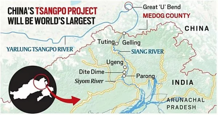
China is building a 60,000 MW hydropower project on the Yarlung Zangbo River (known as the Brahmaputra in India and Jamuna in Bangladesh) in Tibet, near Gelling in Arunachal Pradesh.
- Announced in 2021, the project involves 5 cascade dams and is expected to be completed by the 2030s.
- It will be 3 times more powerful than the Three Gorges Dam, the world’s largest hydropower station.
What are the Key Concerns of India over China’s Mega-Dam on Brahmaputra?
- Ecological and Seismic Risks: Situated in the seismically active Himalayan zone, where the Indian and Eurasian plates meet, the region is highly prone to earthquakes, landslides, and flash floods.
- The project threatens large-scale displacement, similar to the Three Gorges Dam, which displaced over 1.3 million people.
- The dam could act as a “water bomb” and China may weaponise the dam to exert geopolitical pressure on India, particularly after India’s suspension of the Indus Waters Treaty following the Pahalgam terror attack.
- Hydrological & Environmental Impact: The Brahmaputra is vital for agriculture, livelihoods, and biodiversity.
- Sudden water release or diversion could devastate ecosystems, particularly in tribal regions like the Siang belt, home to the Adi tribe.
- Loss of Traditional Knowledge: Artificial flow regulation undermines indigenous flood management systems, increasing vulnerability to climate extremes and displacing centuries-old practices.
- Legal & Diplomatic Gaps: China's unilateral actions disregard India’s riparian rights, as China is not a signatory to any international water-sharing treaty.
- Threat to Regional Water & Food Security: The dam could impact irrigation, hydropower, and flood regulation in India’s northeastern states, threatening water, food, and energy security.
What is India’s Response on China’s Construction of Dams on Brahmaputra?
- Siang Upper Multipurpose Project: India plans a around 11.2 GW hydropower project in Arunachal Pradesh as a strategic and water-security response. It will regulate floods from upstream Chinese dams.
- The project involves local tribal engagement, especially the Adi community.
- Monitoring & River Contribution: Though India has only around 34% of the basin, it contributes over 80% of the Brahmaputra’s flow due to 2,371 mm rainfall and snowmelt, unlike Tibet’s 300 mm.
- Indian tributaries, especially in Arunachal Pradesh and Assam, contribute 30% of water resources and 41% of hydropower potential, with Arunachal Pradesh playing a key role despite challenges.
- Proposed River Linking Projects:
- Manas–Sankosh–Teesta–Ganga Link: Aims to connect the Manas (a Brahmaputra tributary) to the Ganga via Sankosh and Teesta.
- Jogighopa–Teesta–Farakka Link: Proposes linking the Brahmaputra at Jogighopa Barrage to the Ganga at Farakka.
- Diplomatic Dialogue & CBMs: India raised concerns with China regarding Chinese infrastructure and its impact on downstream flow.
- Bilateral talks held in Beijing (March 2025) addressed water-sharing and border disengagement.
- Confidence-Building Measures (CBM) include resumption of tourist visas and Kailash Mansarovar Yatra after 5 years.
- Bilateral talks held in Beijing (March 2025) addressed water-sharing and border disengagement.
What Measures can India take to Address Risk from China’s Brahmaputra Dams?
- Accelerate Strategic Water Infrastructure: India must fast-track projects like the Upper Siang Hydropower Project in Arunachal Pradesh, featuring a 300-metre-high dam capable of absorbing upstream flow variations.
- Parallelly, expanding storage capacity across the Brahmaputra basin will help mitigate risks of flooding and seasonal water stress arising from Chinese interventions.
- Enhance Scientific & Institutional Preparedness: Conduct scientific assessment of the ecological and geopolitical risks posed by China’s dam-building spree.
- Strengthening institutional capabilities for real-time data modelling and predictive analytics, as highlighted by Institute for Defence Studies and Analyses (IDSA) will enable timely responses to potential water weaponisation.
- Implement Interlinking & Channel Diversion Plans: India should operationalise National Water Development Agency (NWDA)’s interlinking plans, connecting Brahmaputra tributaries to the Ganga basin to redirect excess water to drought-prone regions.
- Additionally, inland channel systems can serve as buffers to manage monsoon overflow and reduce flood vulnerability.
- Strengthen Diplomacy & Regional Cooperation: China has ceased sharing crucial hydrological data with India since 2022.
- The Brahmaputra MoU, in place since 2002, expired in June 2023, and the Sutlej River MoU, from 2005, expired in November 2020 and has not been renewed since.
- India should push for diplomatic channels with China to obtain detailed real-time hydrological and project data to assess downstream impact on a continuous basis.
- Also, developing regional coordination with Bhutan, Bangladesh, and Myanmar is vital for joint disaster preparedness, early warning systems, and collective transboundary water governance.
The Key Facts Related to Brahmaputra River System
- Origin & Course: The Brahmaputra River originates from the Chemayungdung Glacier in the Kailash Range near Mansarovar Lake in Tibet, where it is called the Yarlung Tsangpo.
- It enters India through Arunachal Pradesh as the Siang (or Dihang), flows through Assam, and enters Bangladesh as the Jamuna after merging with the Teesta River. It then joins the Ganga (Padma) near Goalundo Ghat and finally merges with the Meghna River, draining into the Bay of Bengal.
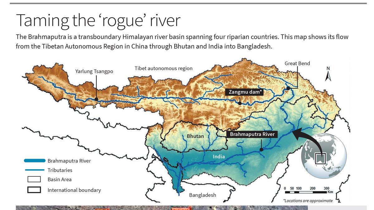
- Basin: The Brahmaputra River Basin spans Tibet (China), Bhutan, India, and Bangladesh. In India, its catchment area covers Arunachal Pradesh, Assam, West Bengal, Meghalaya, Nagaland, and Sikkim.
- The basin is bounded by the Himalayas to the north and west, the Patkai Hills to the east, and the Assam Hills to the south.
- The Brahmaputra is 2,900 km long, with only 916 km flowing through India. (The Ganges is the longest river entirely within India).
- Major Tributaries:
- Right Bank: Lohit, Dibang, Subansiri, Jiabharali, Dhansiri, Manas, Torsa, Sankosh, Teesta
- Left Bank: Burhidihing, Desang, Dikhow, Dhansiri (south), Kopili
- Ecological & Hydrological Significance: The Brahmaputra Basin holds over 30% of India’s total water resources and contributes around 41% of the country’s hydropower potential.
- It supports critical biodiversity zones, including Kaziranga and Manas National Parks, and rich ecosystems.
- The basin is also characterized by deciduous forests in the valley and surrounding hills, making it vital for both ecological balance and sustainable development.
- It supports critical biodiversity zones, including Kaziranga and Manas National Parks, and rich ecosystems.
- Unique Features: Majuli, the world’s largest river island, and Umananda, the smallest river island, are both located on the Brahmaputra River in Assam, highlighting its unique fluvial dynamics.
|
Read More: Transboundary Rivers of India Read More: Hydro Electric Projects in Brahmaputra Basin (India) |
UPSC Civil Services Examination Previous Year Question (PYQ)
Prelims:
Q. With reference to river Teesta, consider the following statements: (2017)
- The source of river Teesta is the same as that of Brahmaputra but it flows through Sikkim.
- River Rangeet originates in Sikkim and it is a tributary of river Teesta.
- River Teesta flows into Bay of Bengal on the border of India and Bangladesh.
Which of the statements given above is/are correct?
(a) 1 and 3 only
(b) 2 only
(c) 2 and 3 only
(d) 1, 2 and 3
Ans: (b)
Mains:
Q. “China is using its economic relations and positive trade surplus as tools to develop potential military power status in Asia”. In the light of this statement, discuss its impact on India as her neighbour. (2017)


