Indian Polity
Statehood and 6th Schedule Demand in Ladakh
For Prelims: 6th Schedule, Public Services Commission (PSC), Union Territory (UT), Article 370, Autonomous District Councils (ADCs), Article 244(2), Governor, Constitutional Amendment, Ladakh Reservation (Amendment) Regulation, 2025, Article 371.
For Mains: Rationale behind Ladakh’s demand for statehood and 6th Schedule status and associated concerns, Key facts regarding 6th Schedule of the Indian Constitution. Measures needed to address Ladakh’s governance needs.
Why in News?
Protests were organised in Leh and Kargil demanding full statehood for Ladakh, 6th schedule status, dedicated Public Services Commission (PSC) and 2 Parliamentary seats for Ladakh.
- The protests were jointly organised by the Leh Apex Body (LAB) and the Kargil Democratic Alliance (KDA) to protect local land and cultural rights.
Summary
- Ladakh seeks Statehood and Sixth Schedule status to address a "representation deficit" and protect its 97% tribal population and fragile ecology.
- While the government cites strategic security and constitutional hurdles as concerns, measures like strengthening LAHDCs and ensuring domicile-based recruitment are vital.
- A balanced, phased approach is essential for regional stability.
What is the Rationale Behind Ladakh’s Demand for Statehood and 6th Schedule Status?
- Restoration of Democratic Representation: Ladakh’s transition to a Union Territory (UT) without a legislature in 2019 under the Jammu & Kashmir Reorganisation Act, 2019 created a "representation deficit." Previously, Ladakh had 4 MLAs in the J&K Assembly. Now, decision-making has shifted from elected locals to unelected bureaucrats.
- While the Ladakh Autonomous Hill Development Councils (LAHDCs) exist, they lack the legislative teeth of a state assembly. Leaders argue these councils have been sidelined, leaving "outsiders" to decide Ladakh’s fate.
- Safeguards for Tribal Identity and Resource Sovereignty: Over 97% of Ladakh’s population belongs to tribal communities, making it a predominantly tribal region. The abrogation of Article 370 removed the historical "special status" that protected Ladakhi land and jobs.
- Without Autonomous District Councils (ADCs), Ladakh lacks the legislative power to protect tribal customs and its fragile "cold desert" ecosystem. This leaves the region vulnerable to unchecked mega-projects, industrial influx, and environmental disasters that threaten vital glaciers and water resources.
- Economic Autonomy: The lack of a Public Service Commission (PSC) means there is no local mechanism for high-level job recruitment. With graduate unemployment at 26.5% (double the national average), locals demand domicile-based reservations.
- They believe statehood would allow them to create a tailored job policy that prioritizes Ladakhis over "outsiders”.
- Strategic Security through Local Trust: In the light of the China-Pakistan Axis, proponents argue that national security is strongest when the local population feels empowered and integrated. By granting 6th Schedule status, the government can manage military logistics while letting locals manage their internal affairs, thereby fostering a "partnership" model of border security.
Sixth Schedule
- About: The 6th Schedule under Article 244(2) of the Constitution establishes a unique autonomous administrative framework for tribal areas in the four northeastern states of Assam, Meghalaya, Tripura, and Mizoram, aiming to preserve their distinct social, cultural, and customary practices.
- Key Features:
- Autonomous District Councils (ADCs): Tribal areas are organized into autonomous districts. The Governor has the power to alter the boundaries of these districts and divide them into autonomous regions, particularly where multiple tribes coexist.
- ADCs are composed of 30 members, with 26 elected by adult franchise and 4 nominated by the Governor. These councils, which currently number 10 across the four states, have a tenure of 5 years.
- Legislative Authority: ADCs possess significant legislative powers, allowing them to enact laws on key subjects such as land, forests, water, shifting cultivation (jhum), village administration, marriage, inheritance, and social customs. However, all such laws require the assent of the Governor.
- Judicial Powers: The councils have the authority to constitute village courts to adjudicate tribal disputes, with the Governor defining the extent of the High Court's jurisdiction over these matters.
- Administrative and Financial Autonomy: Councils can manage local institutions like primary schools and dispensaries, regulate markets and roads, and control money-lending and trading by non-tribals. They are also empowered to collect land revenue and impose taxes.
- Immunity from Ordinary Legislation: An important feature is that Acts of Parliament or the State Legislature may not apply to these areas, or may apply only with specific modifications, ensuring autonomy from standard legal frameworks.
- Autonomous District Councils (ADCs): Tribal areas are organized into autonomous districts. The Governor has the power to alter the boundaries of these districts and divide them into autonomous regions, particularly where multiple tribes coexist.
What Concerns are Associated with Ladakh’s Demand for Statehood and 6th Schedule Status?
- Strategic and Security Risks: Ladakh is a critical "buffer zone" sharing disputed borders with both China (LAC) and Pakistan (LoC). Direct Union Territory (UT) status ensures a clear chain of command, allowing for swift military-civil coordination.
- Critics argue that statehood could introduce political friction that might complicate India's diplomatic posture and strategic control during border stand-offs.
- Constitutional and Legal Hurdles: The 6th Schedule was explicitly designed for tribal areas in the Northeast. Extending it to Ladakh would require a major Constitutional Amendment. It could also trigger similar demands from other tribal regions across India (e.g., Gorkhaland or Bodoland), potentially destabilizing the current federal balance.
- Administrative Complexity: With a small population (approx. 3 lakh), establishing a full state apparatus (High Court, Public Service Commission, and vast bureaucracy) would be economically unviable and administratively inefficient.
- Intra-Regional Diversity: The two districts in Ladakh (i.e., Leh and Kargil) have historically divergent religious and political aspirations. There are concerns that full statehood might sharpen identity politics between the Buddhist-majority Leh and Muslim-majority Kargil, leading to governance deadlocks.
- Existing Protections: The Ladakh Reservation (Amendment) Regulation, 2025, has provided an 85% reservation for local residents in government jobs and defined specific domicile criteria, including 15-year residency.
- Additionally, it notified English, Hindi, Urdu, Bhoti, and Purgi as official languages and mandated a one-third rotating reservation for women in the LAHDC of Leh and Kargil, through rotation.
What Measures are Needed to Address Ladakh’s Governance Needs?
- Strengthening Existing Institutions: Grant the LAHDCs expanded legislative, executive, and judicial authority over land, water, and culture. This avoids immediate constitutional hurdles while fostering grassroots democracy.
- Customized Constitutional Framework: If a full 6th Schedule inclusion is not feasible, Parliament could enact a tailored framework (similar to Article 371) to safeguard demographic identity and empower elected bodies.
- Stringent Land and Environmental Safeguards: Enacting a special Land Regulation Law to restrict land ownership to domiciled locals, alongside carrying capacity limits on tourism to protect the high-altitude "cold desert" ecosystem.
- Institutionalized Dialogue Platforms: Forming a permanent consultation forum involving the Leh Apex Body (LAB), Kargil Democratic Alliance (KDA), and central agencies to build trust and resolve conflicts.
- Phased Implementation and Pilot Projects: Adopting a gradual approach to test new governance models, ensuring they are responsive to the evolving needs of both the Leh and Kargil districts.
Conclusion
The Ladakh movement represents a critical intersection of democratic aspirations and strategic security. While the demand for Statehood and Sixth Schedule status seeks to address a “representation deficit” and protect a fragile ecosystem, it must be balanced against national security imperatives and administrative viability. A consensus-based, tailored constitutional framework remains the most sustainable path forward.
|
Drishti Mains Question: Discuss the implications of granting statehood to Ladakh in the context of national security and federal governance. |
Frequently Asked Questions (FAQs)
1. Why are protests being held in Leh and Kargil?
Protests demand full statehood, Sixth Schedule status, a Public Service Commission, and two parliamentary seats to protect land, jobs, and tribal identity in Ladakh.
2. What is the Sixth Schedule of the Constitution?
The Sixth Schedule under Article 244(2) provides Autonomous District Councils (ADCs) with legislative, administrative, and judicial powers in tribal areas of Assam, Meghalaya, Tripura, and Mizoram.
3. What recent administrative measure addresses job concerns in Ladakh?
The Ladakh Reservation (Amendment) Regulation, 2025, which raised the overall reservation cap to 85% and set strict domicile criteria (15 years residency) for recruitment.
UPSC Civil Services Examination, Previous Year Questions (PYQs)
Prelims
Q. Under which Schedule of the Constitution of India can the transfer of tribal land to private parties for mining be declared null and void? (2019)
(a) Third Schedule
(b) Fifth Schedule
(c) Ninth Schedule
(d) Twelfth Schedule
Ans: (b)
Q. The Government enacted the Panchayat Extension to Scheduled Areas (PESA) Act in 1996. Which one of the following is not identified as its objective? (2013)
(a) To provide self-governance
(b) To recognize traditional rights
(c) To create autonomous regions in tribal areas
(d) To free tribal people from exploitation
Ans: (c)
Q. Which of the following provisions of the Constitution of India have a bearing on Education? (2012)
- Directive Principles of State Policy
- Rural and Urban Local Bodies
- Fifth Schedule
- Sixth Schedule
- Seventh Schedule
Select the correct answer using the codes given below:
(a) 1 and 2 only
(b) 3, 4 and 5 only
(c) 1, 2 and 5 only
(d) 1, 2, 3, 4 and 5
Ans: (d)
Mains
Q. To what extent is Article 370 of the Indian Constitution, bearing marginal note “Temporary provision with respect to the State of Jammu and Kashmir”, temporary? Discuss the future prospects of this provision in the context of Indian polity. (2016)
Q. Why are the tribals in India referred to as ‘the Scheduled Tribes? Indicate the major provisions enshrined in the Constitution of India for their upliftment. (2016)


Economy
Washington Consensus
For Prelims: International Monetary Fund (IMF), World Bank, Liberalisation, Privatisation, Globalisation, Deregulation, Washington Consensus, Asian Development Bank,
For Mains: Washington Consensus and its impact on global economic policy, Beijing Consensus and Cornwall Consensus, Economic nationalism in the contemporary global order.
Why in News?
The Washington Consensus (WC), once considered a “talisman” of economic policy, is increasingly viewed as outdated in today’s multipolar, digital, and geopolitically fragmented world.
- Recent global developments, such as protectionism, industrial policy revival, supply chain restructuring, and economic nationalism, have revived debates about the relevance of the WC model.
Summary
- The Washington Consensus, once promoted as a universal model of liberalisation, privatisation, and deregulation, is increasingly being questioned as global economies shift toward industrial policy, economic nationalism, and strategic supply chains.
- In the emerging post-Washington Consensus era, countries like India must balance market reforms with strategic state intervention, strengthen domestic industries, and push for more inclusive global economic governance.
What is Washington Consensus (WC)?
- About: The Washington Consensus (WC) refers to a set of economic policy prescriptions aimed at promoting macroeconomic stability and market-oriented reforms in developing countries.
- The term was coined by economist John Williamson in 1989 to describe the policy approach advocated by Washington-based institutions such as the International Monetary Fund (IMF), the World Bank, and the US Treasury.
- Core Principles: The Consensus essentially promoted a neoliberal ideology of Liberalisation, Privatisation, Globalisation, and Deregulation to encourage market-led economic growth.
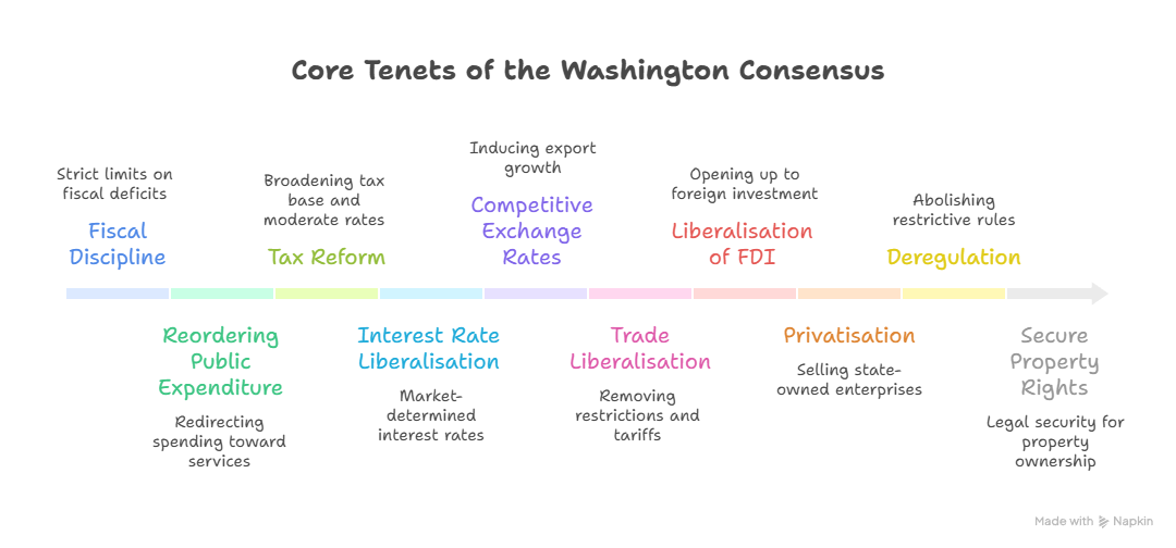
- WC as a “Talisman” of Economic Policy: For decades, the Washington Consensus was viewed as a "talisman" or a magic formula for economic prosperity.
- Perceived Universal Solution: In the 1980s–90s, when many developing countries faced debt crises, hyperinflation, and slow growth, the WC was promoted as a standard policy formula of liberalisation, privatisation, and globalisation, seen as the undisputed path to macroeconomic stability and economic growth.
- India’s 1991 Reforms: India’s historic 1991 LPG (Liberalisation, Privatisation, Globalisation) reforms were heavily influenced by these principles, which helped pull the country out of a severe Balance of Payments (BoP) crisis and ushered in an era of high growth.
- Trickle-Down Growth Belief: WC was based on the idea that free markets and reduced government intervention would generate growth, which would eventually reduce poverty through “trickle-down” effects.
- Global Integration: It successfully drove the era of hyper-globalisation, leading to the rapid expansion of global supply chains and massive wealth creation in emerging markets like East Asia.
- Institutional Support: It was strongly promoted by regional bodies like the Asian Development Bank (ADB) and Bretton Woods institutions such as the IMF and World Bank, giving it the status of a dominant global economic policy framework.
What are the Criticisms Regarding the Relevance of the Washington Consensus (WC)?
- “One-Size-Fits-All” Approach: The WC applied uniform economic reforms to diverse developing countries, ignoring their local political, cultural, and institutional contexts.
- The WC was largely formulated in Western capitals without meaningful participation from developing countries, creating a policy mismatch with local realities.
- While some countries like East Asian economies and Chile combined market reforms with strong state intervention, others particularly in Latin America and post-Soviet states experienced debt crises, rising inequality, and social unrest.
- Severe Social Costs and Rising Inequality: Policies of fiscal austerity and structural adjustment forced cuts in food subsidies, healthcare, and education, often increasing poverty, unemployment, and wealth inequality.
- The assumption that market-led growth would automatically reduce poverty often failed, leading to persistent inequality and social unrest.
- Financial Instability: Rapid capital account liberalisation exposed economies to volatile “hot money” flows, contributing to crises such as the Asian Financial Crisis (1997) and the Argentine economic crisis (2001).
- Rejection of Industrial Policy: The Consensus discouraged state-led industrial strategies, while WTO rules such as TRIMs, TRIPS, and subsidy regulations restricted developing countries’ ability to support domestic industries.
- Many successful economies like the US, Japan, and South Korea historically used protectionism and subsidies to build domestic industries.
- Excessive Faith in Deregulation: The model promoted free markets and deregulation, even in countries with weak institutions and underdeveloped market systems, particularly in Africa and least developed economies.
- Critics argue developed countries used protectionist policies during their development, but later promoted free-market rules for developing nations, limiting their policy space.
- Loss of Economic Sovereignty: WC reforms were often imposed as conditionalities for IMF and World Bank loans, reducing policy autonomy of developing countries and creating a democratic deficit.
- Backlash and Rise of Economic Nationalism: Growing dissatisfaction with globalization has contributed to protectionist policies, tariffs, and industrial subsidies, even in countries that once championed free markets.
Alternative Models
- The Beijing Consensus: A model characterized by heavy state capitalism, political authoritarianism, and aggressive state-led investments (like the Belt and Road Initiative), which has appealed to many developing nations.
- The Cornwall Consensus (2021): Proposed during the G7 summit, this framework advocates for state intervention to achieve broader societal goals such as environmental sustainability, social equity, and economic resilience rather than just market efficiency.
What Measures can India Take in the Post-Washington Consensus Global Economic Order?
- Calibrated Industrial Policy: India must continue to champion active state support for strategic sectors.
- Initiatives like the Production-Linked Incentive (PLI) schemes for semiconductors, green energy, and pharmaceuticals are crucial steps to build domestic manufacturing capacities.
- Building Supply Chain Resilience: The focus must shift from pure cost-efficiency to economic security.
- India should actively participate in "friend-shoring" initiatives and regional frameworks (like the Indo-Pacific Economic Framework) to de-risk its supply chains and reduce over-reliance on single, hostile geographies for critical raw materials.
- Prioritizing Targeted Public Investment: While macroeconomic stability and fiscal prudence remain important, they should not trigger austerity measures that choke growth.
- The state must lead capital expenditure in physical infrastructure (via PM Gati Shakti), digital public infrastructure (DPI), education, and healthcare.
- Balancing Protectionism with Global Integration: India must walk a tightrope using calibrated tariffs to protect its vulnerable Micro, Small, and Medium Enterprises (MSMEs) and infant industries, while simultaneously negotiating equitable, new-age Free Trade Agreements (FTAs) with developed economies.
- Spearheading the Global South’s Agenda: India must leverage multilateral platforms like the G20, BRICS, and the Shanghai Cooperation Organisation (SCO) to push for the democratization of Bretton Woods institutions and the WTO.
- The goal is to ensure that future global economic frameworks are collaborative and reflect the realities of developing nations, rather than being coercive.
- Investing in the Green Transition: As the Cornwall Consensus highlights the need for sustainable growth, India must accelerate its National Green Hydrogen Mission and investments in indigenous renewable technologies.
- This ensures economic growth aligns with climate resilience without compromising developmental goals.
Conclusion
The demise of the WC marks the end of an era where free markets were viewed as a universal panacea. For India, the current multipolar world offers a unique window of opportunity. By blending the dynamism of market economics with strategic, targeted state intervention, India can safeguard its economic sovereignty and emerge as a resilient pillar of the new global economic architecture.
|
Drishti Mains Question: "The Washington Consensus, once considered the talisman for economic development, has lost its relevance in the contemporary geopolitical and economic landscape." Discuss. |
Frequently Asked Questions (FAQs)
1. What is the Washington Consensus?
TheWashington Consensus refers to a set of 10 economic policy prescriptions promoting liberalisation, privatisation, and deregulation, formulated by John Williamson in 1989 and promoted by IMF, World Bank, and the U.S. Treasury.
2. Why was the Washington Consensus considered a “talisman” of economic policy?
It was widely believed to be auniversal formula for economic stability and growth, especially during the 1980s–90s debt crises in developing countries.
3. How did the Washington Consensus influence India’s economic reforms?
India’s1991 LPG reforms (Liberalisation, Privatisation, Globalisation) were influenced by WC principles and helped resolve the Balance of Payments crisis, initiating decades of economic growth.
4. What are the major criticisms of the Washington Consensus?
Critics highlight itsone-size-fits-all approach, rising inequality, financial instability, and restrictions on industrial policy imposed through WTO rules such as TRIMs and TRIPS.
5. What alternative development models have emerged to challenge the Washington Consensus?
Models such as theBeijing Consensus (state-led development) and the Cornwall Consensus (state intervention for sustainability and equity) offer alternative frameworks for economic development.


Important Facts For Prelims
NavIC Navigation System
Why in News?
The Indian Space Research Organisation (ISRO) announced that the atomic clock onboard the Indian Regional Navigation Satellite System (IRNSS)-1F satellite of India’s regional navigation system stopped functioning.
- This comes amid other technical setbacks in India’s navigation constellation, including the NVS-02 satellite’s failure to reach its final orbit, raising concerns about the reliability of NavIC (Navigation with Indian Constellation).
What is IRNSS or NavIC?
- About: The Indian Regional Navigation Satellite System (IRNSS), operationally known as Navigation with Indian Constellation (NavIC), is India's indigenous satellite navigation system.
- It was designed to provide accurate positioning information to users in India and up to 1500 km beyond its borders, which constitutes the Primary Service Area.
- In addition, an Extended Service Area covers the region between the primary area and the rectangle bounded by 30° South to 50° North latitude and 30° East to 130° East longitude.
- Need for NavIC: The project was initiated to ensure strategic autonomy in navigation services.
- During the 1999 Kargil conflict, the US denied India access to GPS data, highlighting the risks of relying on foreign systems. To address this vulnerability, India approved the NavIC project in 2006.
- NavIC Services:
- Standard Positioning Service (SPS) is available to all civilian users and offers positioning information for general navigation purposes.
- Restricted Service (RS) is an encrypted service available only to authorised users, primarily for strategic and defence applications.
- The system is designed to deliver position accuracy better than 20 metres within the primary service area.
- Key Features: NavIC’s Standard Positioning Service provides accuracy of about 5–10 metres across India.
- Accuracy around 20 metres is expected in regions up to 1,500 km beyond India.
- Unlike GPS, NavIC uses dual frequencies (L and S bands), allowing better correction of atmospheric errors and potentially higher accuracy.
- Works better than global systems in difficult terrains such as valleys, forests, and urban areas where GPS signals may weaken.
- Applications of NavIC: Supports terrestrial, aerial, and marine navigation, disaster management, and vehicle tracking and fleet management.
- Enables integration with mobile phones and smart devices, provides precise timing services, and supports mapping, geodetic data collection, and navigation assistance for drivers, hikers, and travellers.
- NavIC Satellite Constellation Performance: The NavIC constellation has been built through a series of satellite launches using the Polar Satellite Launch Vehicle (PSLV).
- First Generation (IRNSS Series): The first generation of NavIC satellites includes the IRNSS-1 series, launched between 2013 and 2018.
- Key satellites include IRNSS-1A, 1B, 1C, 1D, 1E, 1F, 1G, and the replacement satellite IRNSS-1I.
- IRNSS-1H (2017), intended to replace IRNSS-1A, failed to reach orbit due to heat shield separation failure.
- The IRNSS-1I was launched in 2018 as a replacement after the 2017 IRNSS-1H mission failed.
- Several satellites in this series have experienced atomic clock failures or are nearing the end of their mission life, affecting navigation services.
- Second Generation (NVS Series): The NVS series represents the second generation of NavIC satellites, developed to improve reliability and expand capabilities.
- It includes NVS-01, NVS-02, and the planned (NVS-03, NVS-04, and NVS-05).
- NVS-01 (2023) is operational and hosts an indigenously developed rubidium (atomic) clock and L1 band signals.
- NVS-02 (2025) faced issues in reaching its final operational orbit due to an onboard technical problem.
- The newer satellites boast a mission life of 12 years, an upgrade from the 10-year lifespan of the previous generation.
- In addition to the L5 and S frequency signals, the new satellites transmit in a third frequency, L1.
- The L1 frequency improves interoperability with other global positioning systems like GPS and allows NavIC data to be used in low-power wearable devices, such as smartwatches.
- Active Satellites: Following the loss of the IRNSS-1F's atomic clock, only four satellites are currently capable of providing positioning data: IRNSS-1B, 1C, 1I, and the new-generation NVS-01.
- First Generation (IRNSS Series): The first generation of NavIC satellites includes the IRNSS-1 series, launched between 2013 and 2018.
- Technological Developments in NavIC:
- Indigenous Atomic Clocks: ISRO developed Indian rubidium atomic clocks to reduce dependence on imported frequency standards. These clocks will power the next generation of satellites (NVS series).
- NavIC-Compatible Chips: Qualcomm chipsets began supporting NavIC signals in 2020.
- Future devices will support L1 band signals, improving compatibility with smartphones and IoT devices.
- Indigenous Microprocessor: The AJIT microprocessor (the first ever microprocessor to be conceptualised, designed, developed and manufactured in India), developed by IIT Bombay, is planned for integration into NavIC receivers.
- Policy and Regulatory Developments: NavIC-based vehicle tracking systems became mandatory for commercial vehicles in India in 2019.
- In 2019, the US recognised NavIC as an allied navigation system under the National Defense Authorization Act, 2020.
- NavIC will also serve as the reference time provider for India’s National Physical Laboratory from 2025.
Other Countries Having Satellite Navigation Systems
- Global Navigation Satellite Systems (GNSS)
- United States: Global Positioning System (GPS)
- Russia: GLONASS (GLObalnaya NAvigatsionnaya Sputnikovaya Sistema)
- European Union: Galileo
- China: BeiDou
- Regional Navigation Systems
- India: NavIC (IRNSS)
- Japan: Quasi-Zenith Satellite System (QZSS), which augments GPS signals over Japan.
- Key Differences in Satellite Constellations
- GPS, GLONASS, and Galileo: Operate with over 20 satellites in Medium Earth Orbit (~20,000 km).
- BeiDou: Uses over 40 satellites in a combination of Medium Earth Orbit and Geosynchronous Orbit (~35,000 km).
- NavIC and QZSS: Have fewer satellites and mainly operate in higher geosynchronous orbits, focusing on regional coverage rather than global navigation.
What is an Atomic Clock?
- About: An atomic clock is an extremely precise timekeeping device that measures time using the natural vibration frequency of atoms (frequency is essentially the inverse of time).
- Unlike ordinary clocks that rely on mechanical movement or quartz crystals, atomic clocks use the stable energy transitions of atoms, making them the most accurate clocks ever created.
- Working Principle: Atomic clocks work by measuring the specific frequency of microwaves required to cause electrons in an atom to change energy levels.
- This frequency is constant for each type of atom and acts as a natural reference for measuring time.
- Accuracy: Atomic clocks are extraordinarily accurate and stable. Some advanced atomic clocks may lose or gain less than a second over millions of years, making them ideal for applications requiring extremely precise timing.
- Use in Navigation: Atomic clocks are widely used in satellite navigation systems such as GPS and NavIC, where they measure the exact time taken by signals to travel between satellites and receivers to determine precise location.
- Importance: Highly precise atomic clocks also help track spacecraft, calculate trajectories, and enable autonomous navigation for deep-space missions.
Frequently Asked Questions (FAQs)
1. What is NavIC?
NavIC (Navigation with Indian Constellation) is India’sindigenous regional satellite navigation system that provides accurate positioning and timing services over India and up to 1500 km beyond its borders.
2. Why was NavIC developed by India?
NavIC was developed to ensurestrategic autonomy in navigation services, especially after the US denied GPS data during the 1999 Kargil conflict.
3. What are the two services provided by NavIC?
NavIC providesStandard Positioning Service (SPS) for civilian users and Restricted Service (RS), an encrypted navigation service for authorised users including the military.
4. Why are atomic clocks important in navigation satellites?
Atomic clocks provideextremely precise timing signals, allowing satellites to measure signal travel time and determine accurate location and positioning.
5. What are the key improvements in the second-generation NavIC satellites (NVS series)?
The NVS satellites featureindigenous rubidium atomic clocks, longer mission life (12 years), and L1 frequency signals, improving accuracy and compatibility with global navigation systems.
UPSC Civil Services Examination, Previous Year Question (PYQ)
Q.1 Which one of the following countries has its own Satellite Navigation System? (2023)
a. Australia
b. Canada
c. Israel
d. Japan
Ans: d
Q.2 With reference to the Indian Regional Navigation Satellite System (IRNSS), consider the following statements: (2018)
- IRNSS has three satellites in geostationary and four satellites in geosynchronous orbits.
- IRNSS covers entire India and about 5500 sq. Km beyond its borders.
- India will have its own satellite navigation system with full global coverage by the middle of 2019.
Which of the statements given above is/are correct?
(a) 1 only
(b) 1 and 2 only
(c) 2 and 3 only
(d) None
Ans: (a)
Mains
Q. Why is Indian Regional Navigational Satellite System (IRNSS) needed? How does it help in navigation? (2018)


Place In News
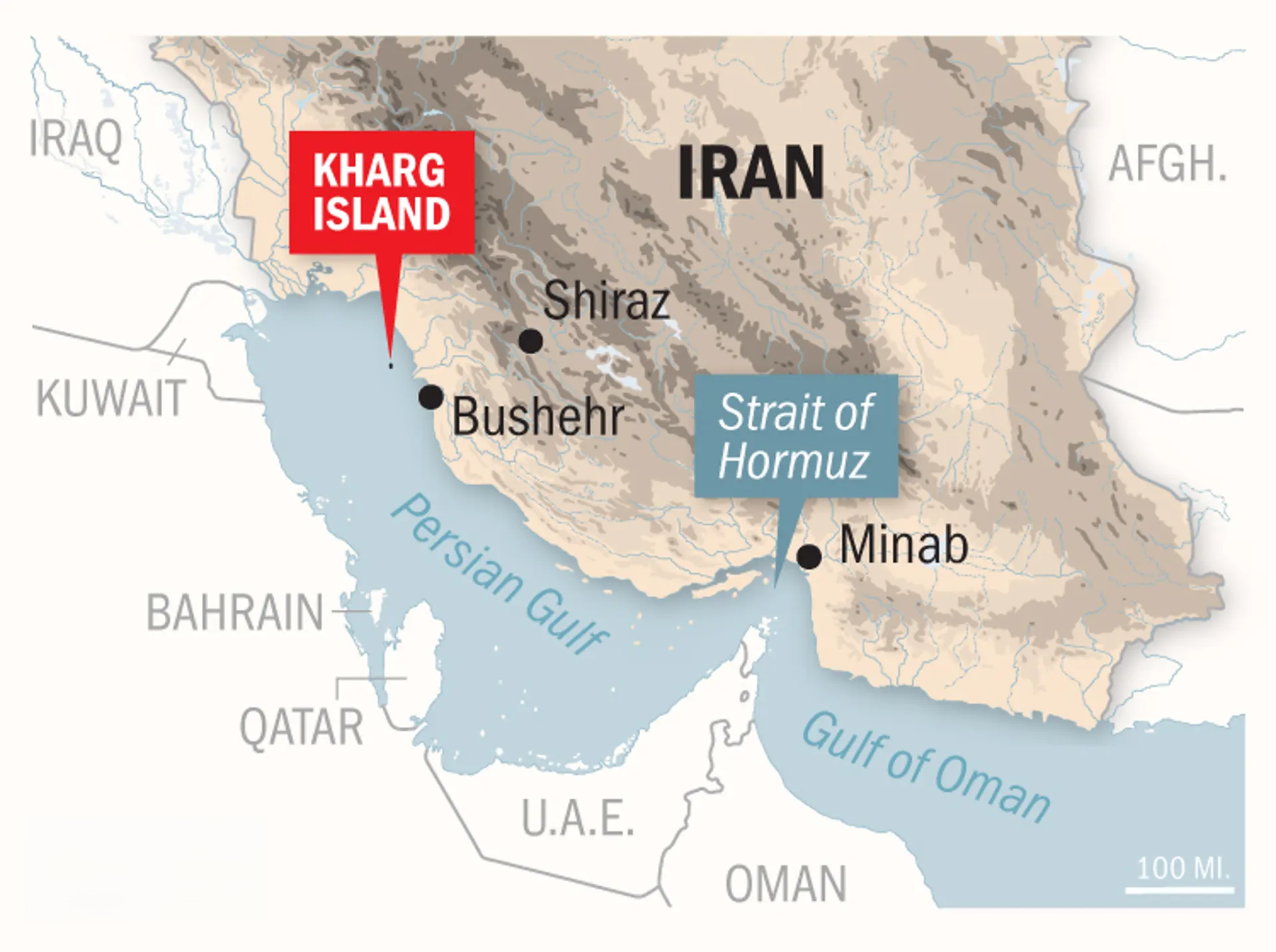
Kharg Island–Fujairah Attacks
Geopolitical escalation in West Asia has intensified after the US reportedly carried out bombing strikes on Iran’s Kharg Island, a crucial oil export hub, while Iran retaliated by striking oil facilities in Fujairah in the United Arab Emirates (UAE).
- Both locations are critical nodes in the global oil supply chain, and attacks threaten international shipping lanes and oil markets.
- Kharg Island:
- Location: Kharg Island is a small Iranian island in the Persian Gulf, about 25 km off Iran’s southwestern coast.
- Kharg was once called the “orphan pearl of the Persian Gulf.” Today, it is often referred to as the “forbidden island” because access is tightly controlled by the Islamic Revolutionary Guard Corps (IRGC).
- Iran’s Main Oil Export Hub: The island became Iran’s primary export centre because it is connected by pipelines to major oil fields such as Ahvaz, Marun, and Gachsaran and has deep waters suitable for supertankers.
- About 90% of Iran’s crude oil exports pass through Kharg Island, with the terminal handling roughly 1.3–1.6 million barrels per day, and the ability to store around 30 million barrels.
- Historical Trade Centre: Kharg has been part of regional trade networks since the 10th century, serving pearl divers and traders moving between India and Basra (Iraq).
- It was later fortified by the Dutch in the 18th century and briefly occupied by the British in the 19th century.
- Location: Kharg Island is a small Iranian island in the Persian Gulf, about 25 km off Iran’s southwestern coast.
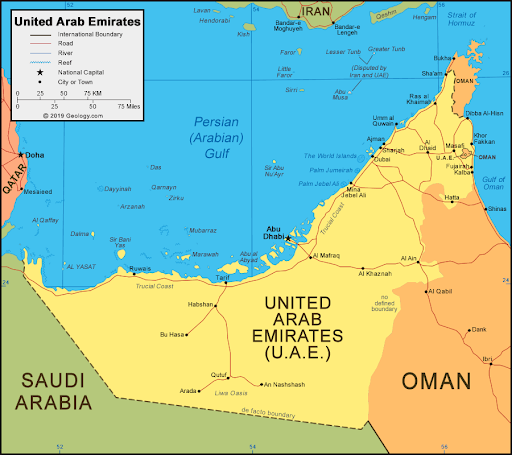
- Fujairah:
- Location: Fujairah is one of the seven emirates of the UAE, located on the Gulf of Oman.
- It is the only UAE emirate without a coastline on the Persian Gulf, giving it strategic importance for energy transport.
- The UAE is bordered by Saudi Arabia to the west and south, and Oman to the east and northeast. It also shares maritime borders in the Persian Gulf with Qatar and Iran.
- Bypassing the Strait of Hormuz: The Habshan–Fujairah pipeline allows UAE oil exports to bypass the Strait of Hormuz, a narrow and vulnerable maritime chokepoint.
- Global Energy Hub: The Port of Fujairah is among the largest oil storage facilities globally and the second-largest ship bunkering hub after Singapore.
- Location: Fujairah is one of the seven emirates of the UAE, located on the Gulf of Oman.
| Read more: Conflict Zones in the US - Israel - Iran War |


Rapid Fire
India’s 1st Manuscript Mapping Drive
The Ministry of Culture has launched a first-of-its-kind three-month nationwide survey to map India’s manuscript heritage.
- The exercise aims to curb intellectual piracy by digitising India’s vast manuscript heritage, which includes the world’s largest collection of about 1 crore manuscripts.
Manuscript Mapping Survey
- About: The survey will be conducted from the district level upwards to locate manuscripts across the country and create a consolidated national database.
- The collected data will be compiled into a national digital repository under the Gyan Bharatam Mission.
- Objective: The initiative aims to preserve, digitise and promote India’s vast manuscript heritage, enhancing accessibility for research and safeguarding cultural knowledge.
- Technology Use: Manuscripts from institutions, collections and individual custodians will be geotagged for conservation, preservation and digitisation needs.
- Gyan Bharatam app will be used by survey teams to upload details, with further standardised digitisation to make them widely accessible.
- Policy Linkage: The initiative aligns with the New Delhi Declaration (Gyan Bharatam Conference) and supports the vision of showcasing India’s culture, literature and consciousness.
- Implementation Framework: Survey will be conducted through state-level committees chaired by the Chief Secretary and district-level committees chaired by the District Magistrate.
| Read more: Gyan Bharatam Mission |


Rapid Fire
Economic Stabilisation Fund
The Lok Sabha approved the 2nd batch of Supplementary Demands for Grants (2025-26), and the Finance Minister introduced the Economic Stabilisation Fund (ESF), a Rs 1 lakh crore fiscal buffer aimed at boosting macroeconomic stability and economic resilience.
- Under Article 115, Supplementary Demands for Grants are required when funds authorised by the Appropriation Act for a service prove insufficient. The President lays them before both the Houses of Parliament for approval before the financial year ends.
Economic Stabilisation Fund
- About: It is designed to act as a "financial shock absorber," protecting the Indian economy from global headwinds such as the West Asia conflict, oil price spikes and supply chain disruptions (e.g, Strait of Hormuz blockade) without breaching fiscal deficit targets.
- Funding Source: A net outgo of Rs 57,381.84 crore is sourced through supplementary demands, while the remainder comes from savings, recoveries, and higher receipts from various ministries.
- The fund will be placed under the reserve funds managed by the Department of Economic Affairs (DEA), Ministry of Finance.
- Fiscal Discipline: The government has emphasized that this allocation does not entail additional borrowing and will not impact the fiscal deficit target of 4.4% for 2025–26 (Revised Estimates).
- Global Comparison: The ESF draws parallels to Sovereign Wealth Funds or Stabilisation Funds in other economies, such as Norway (for oil price fluctuations) and Chile (for copper price shocks).
| Read More: Geoeconomic Fallout of the US-Israel-Iran Conflict on India |


Rapid Fire
60th Jnanpith Award
Eminent Tamil lyricist and author R. Vairamuthu has been selected for the 60th Jnanpith Award, becoming only the 3rd Tamil writer to receive the prize and the 1st to be recognised for Tamil poetry.
- He also won the Sahitya Akademi Award (2003) for his novel Kallikattu Ithikasam. He was also awarded the Padma Shri in 2003 and the Padma Bhushan in 2014.
- The award had previously been conferred on Tamil writers Akilan (1975) and Jayakanthan (2002).
Jnanpith Award
- About: The Jnanpith Award, instituted in 1961 by the Bharatiya Jnanpith, is India's highest literary honour recognising exceptional lifetime contributions by authors.
- Often regarded as the "Nobel Prize of Indian literature," it highlights India's linguistic diversity and literary integrity.
- Institutional Background: The award was established by industrialist Sahu Shanti Prasad Jain and his wife Rama Jain via the Bharatiya Jnanpith, a cultural organization set up in 1944. The first award was conferred in 1965 to G. Sankara Kurup (Malayalam).
- The 1st woman recipient was Ashapurna Devi (Bengali) in 1976, and the 1st English-language winner was Amitav Ghosh in 2018.
- Eligibility and Scope: It is presented annually only to an Indian author for their "outstanding contribution towards literature." From 1965 to 1981, the award was given for a specific book/work. Since 1982, it has been awarded for an author’s lifetime contribution to Indian literature.
- It covers all 22 Eighth Schedule languages as well as English (included in 2013). No posthumous awards are given.
- Prize and Symbolism: The recipient receives a cash prize of Rs 11 lakh, a citation, and a bronze statuette of Vagdevi (Saraswati), the goddess of knowledge. The award is often presented by the President of India.
- Selection Process: A high-level committee (Pravara Parishad) of eminent scholars and litterateurs evaluates nominations based on creativity, vision, and impact on Indian literature.

| Read More: 58th Jnanpith Award |


Rapid Fire
US Investigates India and 59 Others Over ‘Forced Labour’
The US has launched a trade investigation against India and 59 other economies under Section 301 of the Trade Act, 1974 to examine whether their supply chains include goods produced using forced labour.
- The probe aims to address unfair trade advantages arising from lower production costs, which the US Trade Representative (USTR) argues harm American industries and workers.
- The US views forced labour in global supply chains as both a human rights violation and a national security issue.
- Tariff Revival Strategy: The investigation is seen as a way to legally justify reimposing tariffs after the US Supreme Court struck down earlier reciprocal tariffs in 2026.
- Global Scope: The probe targets 60 economies, including India, China, the European Union, UK, Japan, Australia, Canada, Russia, Bangladesh, and Sri Lanka.
- The investigation will examine products made using imported intermediate goods such as cotton and yarn in textiles, critical minerals used in solar panels and electronics, and palm fruit used in biofuels.
- Impact on India: Although India prohibits forced labour under the Bonded Labour System (Abolition) Act, 1976, its export industries may face scrutiny because many rely on raw materials and components imported from China.
- Key sectors such as solar panels (using Chinese polysilicon), electronics (dependent on Chinese sub-assemblies), and textiles and garments (using imported fabrics) could be particularly vulnerable.
- Additionally, India is also facing a separate US investigation on “excess manufacturing capacity” in sectors like solar modules, petrochemicals, and steel.
- If the US finds violations, it may impose heavy tariffs or trade restrictions on imports from affected countries.
- Exporters may need to adopt strict traceability mechanisms to prove that products are free from forced labour.
| Read more: India–US Trade Deal 2026 |