Internal Security
India’s Defence Forces Vision 2047
For Prelims: Quantum sensing, Mission Sudarshan Chakra, Integrated Theatre Commands, Chief of Defence Staff, Defence Industrial Corridor, iDEX (Innovations for Defence Excellence)
For Mains: India’s Defence Forces Vision 2047, Defence modernisation and military reforms in India
Why in News?
The Defence Minister of India unveiled the “Defence Forces Vision 2047: A Roadmap for a Future-Ready Indian Military”. Prepared by the Headquarters Integrated Defence Staff, this vision document outlines a comprehensive strategy to transform the Indian military into an integrated, agile, and multi-domain force by the centenary of India's independence.
Summary
- Defence Forces Vision 2047 is a long-term roadmap to transform India’s military into a technologically advanced, integrated, and multi-domain force through AI, drones, cyber, and space capabilities while strengthening jointness among the Army, Navy, and Air Force.
- The strategy links military modernisation with defence indigenisation and economic growth, aiming to reduce import dependence, strengthen domestic defence manufacturing, and build a self-reliant world-class military by 2047.
What is the 'Defence Forces Vision 2047'?
- About: The document acts as a "meta-strategy," explicitly acknowledging that national security in the 21st century relies as heavily on industrial capacity and technological ecosystems as on direct battlefield capabilities.
- The Three Core Pillars:
- Technological Advancement: Leveraging Artificial Intelligence (AI), autonomous systems, quantum sensing, and advanced surveillance to maintain an edge.
- Jointness and Synergy: Deepening operational synergy across the Army, Navy, and Air Force to avoid duplication and optimize resources.
- Multi-Domain Capability: Operating seamlessly across traditional (land, sea, air) and emerging (cyber, space, cognitive) domains.
- Key Proposals & Structural Reforms:
- Specialized Next-Gen Forces: The roadmap proposes the creation of dedicated structures including a Space Command, Cyber Command, Data Force, Drone Force, and a Cognitive Warfare Action Force.
- Doctrinal Shift: Proposes transition from net-centric warfare to data-centric warfare. The goal is to move from "information superiority" to "decision superiority" in the battlefield.
- Mission Sudarshan Chakra: Under Mission Sudarshan Chakra, the vision proposes expanding ballistic missile and air defence systems to protect India’s strategic, economic, and civilian assets from evolving aerial threats.
- Phased Implementation: The vision outlines a three-phase transition identifying short-term, mid-term, and long-term priorities culminating in a "world-class military" between 2040 and 2047.
- ‘Era of Transition’ (till 2030): Restructuring the military, strengthening deterrence, and boosting indigenous technologies like drones.
- ‘Era of Consolidation’ (2030–2040): Integrating cyber and space warfare and developing layered air-missile defence.
- ‘Era of Excellence’ (2040–2047): Creating a fully integrated, self-reliant all-domain military force.
Significance
- Changing Character of Warfare: Conflicts (US-Iran tensions, Russia–Ukraine War) show how drones, loitering munitions, and cyber attacks dominate modern battlefields. This vision prepares India for hybrid, proxy, and "grey-zone" warfare.
- Geopolitical Realities: India’s expanding strategic interests in the Indo-Pacific region, coupled with persistent border friction, require a shift from a strictly defensive posture to proactive deterrence.
- Economic-Security Nexus: By intertwining the military roadmap with the goal of Viksit Bharat (Developed India) by 2047, the government acknowledges that military modernization cannot be sustained by imports; it requires a booming domestic industrial base.
What are the Challenges in India's Defence Sector?
- Heavy Dependence on Imports: India remains one of the world’s largest arms importers, accounting for about 8.2–8.3% of global arms imports during 2021–2025, making it the second-largest importer globally according to SIPRI.
- Russia alone still supplies around 40% of India’s arms imports, followed by France, Israel, and the United States.
- India produces roughly 70–75% of its defence equipment domestically, meaning a significant portion still relies on imports.
- Budgetary Pressures: India’s defence spending is about 1.9–2.2% of GDP, and a large share goes toward salaries and pensions rather than modernization and capital acquisition.
- Delayed Structural Reforms: The rollout of Integrated Theatre Commands (ITCs) has faced inter-service friction and institutional resistance.
- Slow Procurement and Technological Gaps: Bureaucratic delays and complex procurement procedures often slow down defence acquisition, while India still lacks critical technologies such as jet engines, advanced semiconductors, and stealth systems, affecting military modernization.
- Technological Asymmetry: India still heavily relies on foreign Original Equipment Manufacturers (OEMs) for critical niche technologies, such as advanced jet engines and semiconductor chips.
What are the Measures Taken to Boost Defence Capabilities?
- Capital Budget Earmarking: Around 75% of the Capital Acquisition budget is reserved for domestic defence industries in FY 2026-27 for procurement from domestic industry, directly boosting the local manufacturing ecosystem.
- Institutional Frameworks: The creation of the Chief of Defence Staff (CDS) and the Department of Military Affairs (DMA) to promote jointness in operations and procurement.
- Positive Indigenisation Lists: Banning the import of hundreds of weapons, platforms, and sub-systems to forcefully pivot procurement toward indigenous sources.
- Innovation Ecosystem: Platforms like iDEX (Innovations for Defence Excellence) and the Make-I/II frameworks are enabling start-ups and private firms to participate in R&D, especially in AI, drones, and space-based ISR (Intelligence, Surveillance, and Reconnaissance).
- Defence Corridors & Exports: Two Defence Industrial Corridors have been established in Uttar Pradesh and Tamil Nadu.
- Consequently, defence exports have grown exponentially, with the government targeting Rs 50,000 crore in exports by FY29.
What Measures are Needed to Realize India's Defence Forces Vision 2047?
- Accelerating Theaterisation and Jointness: Overcoming institutional resistance to structural reforms is paramount. The swift rollout of ITCs must be prioritized to pool resources and ensure seamless interoperability.
- Pivoting to Technological Sovereignty: To move from being an assembler to an innovator, India must aggressively pursue indigenous development in critical "chokepoint" technologies under Defence Acquisition Procedure (DAP) 2020.
- This requires incentivizing private sector R&D and securing deep technology-transfer agreements.
- Instituting Agile Procurement Models: Traditional bureaucratic acquisition cycles are too slow for the rapid lifecycle of emerging technologies.
- India must implement an "agile acquisition pathway" specifically designed for software, AI, and cyber tools.
- Budget Rationalization and Innovative Funding: The immediate focus must be on optimizing existing capital.
- This includes exploring alternative funding models like public-private partnerships (PPPs) for defence infrastructure and leveraging defence bonds.
- Cultivating Specialized Human Capital: The shift to data-centric warfare requires a fundamental change in personnel management.
- The military needs to aggressively recruit and retain specialists in AI and cognitive warfare, potentially introducing lateral entry avenues for civilian tech experts.
- Expanding the Geostrategic Export Footprint: A booming domestic industrial base relies on economies of scale.
- India must build upon its recent export successes by aggressively marketing its battle-tested indigenous platforms to friendly nations in the Global South.
Conclusion
The "Defence Forces Vision 2047" is a bold and necessary acknowledgment that future wars will be won as much in tech incubators and assembly lines as on the battlefield. By bridging procurement gaps, enforcing jointness, and securing technological independence, India can successfully build a military apparatus that not only defends its borders but actively deters its adversaries in an increasingly volatile multipolar world.
|
Drishti Mains Question: Defence Forces Vision 2047 is not merely a military modernization plan, but a meta-strategy integrating national security with economic development. Discuss. |
Frequently Asked Questions (FAQs)
Q. What is Defence Forces Vision 2047?
It is a strategic roadmap to transform India’s military into a technologically advanced, integrated, and multi-domain force by the centenary of independence in 2047.
Q. What are the three phases of Defence Forces Vision 2047?
The roadmap includes ‘Era of Transition’ (till 2030), ‘Era of Consolidation’ (2030–2040), and ‘Era of Excellence’ (2040–2047) to gradually build a world-class military.
Q. What is Mission Sudarshan Chakra?
It aims to expand ballistic missile and air defence systems to create a layered shield protecting India’s strategic infrastructure and civilian centres from aerial threats.
Q. Why is defence indigenisation important for India?
Reducing dependence on arms imports strengthens strategic autonomy, domestic industry, and long-term military preparedness.
Q. What major challenge affects India’s defence modernization?
India remains one of the largest arms importers globally, while procurement delays and technological gaps in areas like jet engines and semiconductors slow modernization.
UPSC Civil Services Examination, Previous Year Questions (PYQs)
Q. How is the S-400 air defence system technically superior to any other system presently available in the world? (2021)
Q. Foreign direct investment in the defence sector is now said to be liberalised. What influence this is expected to have on Indian defence and economy in the short and long run? (2014)


International Relations
Xiaokang Villages and India's Border Security
For Prelims: Line of Actual Control (LAC), Salami-slicing Tactics, 2005 India-China Agreement on Political Parameters and Guiding Principles, Siliguri Corridor, Vibrant Villages Programme, Zojila Tunnel, Sela Tunnel, Border Roads Organisation (BRO), Nyoma Airbase, PM GatiShakti framework.
For Mains: Key facts regarding the Xiaokang border defence villages and threats posed to India. Steps India needs to take to strengthen its border infrastructure.
Why in News?
India’s Military leadership warned that China’s rapid construction of 628 "Xiaokang" villages along the Line of Actual Control (LAC), particularly the 90% cluster facing Arunachal Pradesh, is a strategic move to solidify territorial claims through civilian settlement.
- These dual-use villages in contested areas essentially function as permanent, fortified outposts, creating a significant long-term security and sovereignty challenge for India.
Summary
- China is constructing 628 dual-use Xiaokang villages to strengthen territorial claims through "salami-slicing" tactics along the LAC.
- These settlements facilitate military-civil fusion and constant surveillance, pressuring India’s northeastern borders.
- Consequently, India is accelerating the Vibrant Villages Programme and Arunachal Frontier Highway to bolster strategic deterrence.
What are the Xiaokang Border Defence Villages?
- About: Chinese ‘Xiaokang’ Villages refer to a specific category of border settlements constructed or upgraded, primarily in the Tibet Autonomous Region (TAR) along its disputed frontiers. The term "Xiaokang" translates to "moderately prosperous" or "well-off" in English.
- Scale and Investment: Launched around 2017 by the Tibet Autonomous Region (TAR) government, the project involves 628 villages across 21 border counties (3rd level administrative division after prefecture-level cities and provinces) with a state investment of approximately 30 billion yuan.
- Dual-Use Functionality: While framed as rural revitalisation, these settlements serve as dual-use infrastructure, capable of housing People's Liberation Army (PLA) personnel and facilitating rapid military mobilization in contested areas.
- Legal and Strategic Framework: The construction is supported by China's 2022 Land Border Law, which mandates the state to strengthen border defense and promote "coordination between border defense and social, economic development."
- It acts as a "Great Wall of Villages" to strengthen de facto control and territorial claims through "gray-zone" tactics.
- Demographic Engineering: The initiative aims to enhance grassroots Chinese Communist Party control, monitor cross-border activity, and promote Sinicization in Tibet (adoption of Chinese culture and identity) by populating sensitive border zones.
- Infrastructure Sophistication: Beyond housing, the project provides comprehensive modern amenities, including roads, electricity, water supply, and communications, often documented via satellite imagery.
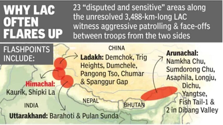
Line of Actual Control
- About: The Line of Actual Control (LAC) is a notional, de facto demarcation line that separates Indian-controlled territory from Chinese-controlled territory, emerging primarily from the post-1962 war positions in the absence of a formally delineated international border.
- Origin: First proposed by Chinese Premier Zhou Enlai in 1959, the concept was initially rejected by India’s former Prime Minister JL Nehru but later formally accepted by India in the 1993 Border Peace and Tranquility Agreement (BPTA) to maintain regional stability.
- Sectoral Division: The LAC is divided into the Western Sector (Ladakh/Aksai Chin), which sees the most friction; the Middle Sector (Uttarakhand/Himachal Pradesh), which is the least disputed; and the Eastern Sector (Arunachal Pradesh/Sikkim), which largely follows the McMahon Line.
- In the Eastern Sector, India recognizes the 1914 Simla Convention's McMahon Line, whereas China rejects its legal validity, referring to Arunachal Pradesh as "South Tibet."
- Perception Gap: A major source of conflict is the discrepancy in length, where India estimates the LAC at 3,488 km while China claims it is only about 2,000 km, leading to overlapping claims in "grey zones."
- Friction Points: Ambiguity in the rugged Himalayan terrain leads to "face-offs" at critical locations such as Depsang Plains, Galwan Valley, Pangong Tso, and Tawang.
How do Xiaokang Border Defence Villages Pose a Threat to India?
- Territorial Assertion: By establishing a "settled population" in disputed areas, China aims to strengthen legal claims under its Land Borders Law (2022), utilizing "salami-slicing" tactics to change the status quo without triggering full-scale conflict.
- Breach of Bilateral Agreements: These constructions are viewed as a violation of the 2005 India-China Agreement on Political Parameters and Guiding Principles, specifically undermining articles related to mutual security and the maintenance of peace and tranquility along the border.
- Dual-Use Infrastructure: Settlements at sites like Zhuangnan and Majiduncun function as forward operating bases, featuring robust logistics, communication networks, and housing designed for rapid PLA mobilization.
- Military-Civil Fusion: Residents act as the state’s "eyes and ears," forming a civilian border defense force that provides constant surveillance, early warning, and intelligence collection against Indian movements.
- Strategic Pressure Points: The placement of these villages near sensitive zones like Tawang and the Siliguri Corridor ("Chicken’s Neck") creates persistent geostrategic pressure on India’s northeastern connectivity.
- Psychological Warfare: The visible modernization of Chinese villages is intended to exert psychological pressure on Indian border communities. This disparity may foster perceptions of relative neglect on the Indian side, indirectly supporting China's narrative of superior governance.
India’s Initiatives to Strengthen Border Infrastructure
What Steps Does India Need to Take to Strengthen its Border Infrastructure?
- Strategic Logistical Connectivity: Accelerate Phase III of the India-China Border Roads (ICBR) programme and flagship projects like the 1,840 km Arunachal Frontier Highway to guarantee all-weather troop mobilization and seamless logistics.
- Civilian-Led Defense: Expand the Vibrant Villages Programme (Phase II) to transform 1,954 border villages into self-sufficient hubs, effectively countering out-migration and creating a "civilian monitoring layer" along the LAC.
- High-Altitude Infrastructure: Prioritize the construction of strategic tunnels (e.g., Zojila, Sela) and all-weather rail links to eliminate seasonal isolation and facilitate the rapid movement of heavy weaponry.
- Aerial and Multimodal Readiness: Upgrade Advanced Landing Grounds (ALGs) like Nyoma airbase and expand helipad networks to support heavy-lift operations and high-resolution aerial reconnaissance.
- Technological Surveillance Integration: Deploy a multi-layered ISR (Intelligence, Surveillance, and Reconnaissance) framework—utilizing 150+ new satellite assets, AI-driven analytics, and drones—to maintain constant situational awareness.
- Energy and Institutional Synergy: Implement renewable energy micro-grids for forward outposts to ensure logistical self-sufficiency while leveraging the PM GatiShakti framework to fast-track inter-ministerial clearances for BRO projects.
- Diplomatic Deterrence: Complement physical infrastructure with sustained engagement through the Working Mechanism for Consultation and Coordination (WMCC) to manage tensions and prevent unintended escalation.
Conclusion
China’s Xiaokang border villages represent a strategic blend of civilian settlement, infrastructure development, and military preparedness aimed at consolidating territorial claims along the Line of Actual Control. For India, the development underscores the urgency of strengthening border infrastructure, surveillance, and local population resilience to safeguard sovereignty and maintain strategic balance in sensitive frontier regions.
|
Drishti Mains Question: Analyze the strategic implications of China’s "Xiaokang" border villages on India's national security and territorial sovereignty. |
Frequently Asked Questions (FAQs)
1. What are Xiaokang border defence villages?
Xiaokang villages are Chinese border settlements built in the Tibet Autonomous Region to promote economic development and strengthen border defence, often serving dual civilian–military purposes.
2. Which law supports the construction of Xiaokang villages?
The China Land Border Law, 2022 mandates strengthening border defence, developing infrastructure, and encouraging civilian settlement in frontier areas.
3. What is India’s response to China’s border village strategy?
India launched the Vibrant Villages Programme to develop border villages, strengthen infrastructure, and retain population along the frontier.
4. What is meant by “gray-zone tactics” in border disputes?
Gray-zone tactics involve incremental actions—such as infrastructure development or civilian settlement—that alter territorial control without triggering open conflict.
UPSC Civil Services Examination, Previous Year Question (PYQ)
Prelims
Q. “Belt and Road Initiative” is sometimes mentioned in the news in the context of the affairs of : (2016)
(a) African Union
(b) Brazil
(c) European Union
(d) China
Ans: (d)
Q.‘Hand-in-Hand 2007’ a joint anti-terrorism military training was held by the officers of the Indian Army and officers of the Army of which one of the following countries? (2008)
(a) China
(b) Japan
(c) Russia
(d) USA
Ans: (a)
Mains
Q. The China-Pakistan Economic Corridor (CPEC) is viewed as a cardinal subset of China’s larger ‘One Belt One Road’ initiative. Give a brief description of CPEC and enumerate the reasons why India has distanced itself from the same. (2018)


Important Facts For Prelims
Nor'westers and Local Winds of India
Why in News?
A severe Nor’wester storm wreaked havoc in Odisha's Mayurbhanj district, leaving a trail of destruction that included uprooted trees, toppled electricity poles, and extensive damage to thatched houses.
What are Nor’westers?
- About: Nor’westers are intense, brief thunderstorms driven by convection that occur across eastern and northeastern India. These violent local winds typically strike during the pre-monsoon months, spanning from April through June.
- Geographical Extent: These storms primarily affect West Bengal, Odisha, Bihar, Jharkhand, Assam, and Tripura, as well as Bangladesh, southern Nepal, and Bhutan. They are most prominent over Gangetic West Bengal and the eastern Gangetic plain.
- Local Nomenclature:
- Kalbaisakhi (Bengali): Translates to the "calamity of the month of Baisakh" (mid-April to mid-May), signifying their destructive and sudden nature.
- Bordoisila or Bardoli Cheerha (Assamese): Named after a "fierce, speedy goddess," reflecting the storm's high wind speeds.
- Formation and Dynamics: They form due to intense daytime heating over the Chota Nagpur Plateau, creating a low-pressure area.
- This draws in warm, moist air from the Bay of Bengal, which interacts with drier, cooler air from the northwest aloft.
- This interaction creates extreme atmospheric instability, high Convective Available Potential Energy (CAPE), and strong vertical wind shear, leading to the rapid development of dark Cumulonimbus clouds appearing suddenly.
- Key Characteristics:
- Timing: They typically occur in the late afternoon or evening.
- Direction: They travel from the northwest towards the southeast, hence the name "Nor'wester."
- Intensity: They are characterized by gale-force winds (often exceeding 100 km/h), torrential rain, intense lightning, thunder, hailstorms, and occasionally tornadoes.
- Duration: They are short-lived at a single location, usually lasting 1–2 hours, but can travel long distances.
- Significance and Impacts:
|
Significance |
Impacts |
|
Relief from Heat: Provides a sharp temperature drop, offering brief but significant respite from the scorching pre-monsoon heat and humidity. |
Structural Damage: Gale-force winds uproot trees, damage power lines, and destroy kutcha houses and infrastructure. |
|
Agricultural and Water Source: The heavy downpours replenish ponds, wells, and water bodies, providing critical water for the dry summer months and standing crops like tea and paddy. |
Loss of Life and Property: Lightning strikes, falling trees, and collapsing structures often lead to casualties and significant property loss. |
|
Cultural Significance: Deeply ingrained in regional culture, particularly in Bengali literature and Rabindra Sangeet, where it symbolizes nature's fury and the arrival of the new year. |
Crop Destruction: Hailstorms and intense winds cause extensive damage to orchards (mangoes) and ready-to-harvest crops. |
|
Precursor to Monsoon: Their arrival signals the transition period and the approaching Southwest Monsoon, marking an important phase in the agricultural calendar. |
Disruption: They cause widespread disruption to daily life, including transport (flights, trains, and roads) and power supply, leading to waterlogging in urban areas. |
What are the Various Local Winds of India and their Socio-economic Influence?
|
Local Wind |
Characteristics |
Region(s) Affected |
Season/Period |
Socio-Economic Influence |
|
Hot, dry, dusty, strong afternoon wind |
Northern India (Indo-Gangetic plains, Rajasthan, Punjab, Haryana, Uttar Pradesh) |
Summer (April–June) |
Causes heatstroke, dehydration, and health risks; reduces labor productivity; leads to 10–15% crop yield losses (e.g., wheat); occasional fatalities; aids grain winnowing and reduces mosquito populations. |
|
|
Mango Showers |
Pre-monsoon showers, often with thunderstorms |
Southern India (Kerala, coastal Karnataka, Tamil Nadu) |
Late April–June |
Aids mango ripening, supports horticulture, signals monsoon onset, and improves soil moisture for agriculture. |
|
Blossom Showers (Coffee/ Cherry Blossom Showers) |
Light to moderate pre-monsoon rainfall, sometimes with thunderstorms |
Southern India (Kerala, and nearby areas) |
March–May (pre-monsoon) |
Triggers blossoming of coffee flowers, essential for coffee plantations; supports early agricultural activities and improves soil moisture and horticultural productivity. |
|
Aandhi |
Violent dust storms/squalls |
Northwestern and Central India (Rajasthan, Punjab, Haryana, Uttar Pradesh) |
Pre-monsoon (May–June) |
Reduces visibility, disrupts transport and daily activities, damages standing crops and property, and contributes to soil erosion in arid areas. |
|
Sea Breeze |
Cool, moist wind from sea to land |
Coastal regions (Mumbai, Chennai, Kolkata, Goa) |
Daytime, year-round (stronger in summer) |
Moderates extreme heat in coastal cities, improves thermal comfort, and supports tourism; minimal negative impact. |
|
Land Breeze |
Cool wind from land to sea |
Coastal regions |
Night time, year-round |
Provides cooling relief in coastal areas and supports fishing and marine activities by influencing sea conditions. |
|
Mountain/ Valley Breeze |
Upslope winds (day) and downslope winds (night) |
Himalayan and other hilly regions (Uttarakhand, Himachal Pradesh, Northeast hills) |
Diurnal cycle |
Influences local agriculture and settlement patterns; may cause frost in valleys affecting crops; helps pollution dispersion in valleys. |
|
Elephanta |
Moist winds blowing from sea toward the land. |
Malabar Coast (Kerala/Maharashtra) |
End of monsoon |
Helps in the final stages of the Kharif crop cycle and provides a cooling effect after the humidity of the monsoon. |
Frequently Asked Questions (FAQs)
1. What are Nor’westers?
Nor’westers are severe pre-monsoon convective thunderstorms occurring mainly in eastern and northeastern India, bringing strong winds, lightning, hail, and heavy rainfall.
2. Why are Nor’westers called Kalbaisakhi?
In Bengali, Kalbaisakhi means “calamity of the month of Baisakh” (mid-April–mid-May), reflecting the sudden and destructive nature of these storms.
3. What atmospheric conditions lead to Nor’wester formation?
Intense land heating over the Chota Nagpur Plateau, moisture influx from the Bay of Bengal, and interaction with cool, dry northwesterly winds create instability and high CAPE, producing cumulonimbus thunderstorms.
4. What is the difference between Loo and Nor’westers?
Loo is a hot, dry summer wind over northern India, while Nor’westers are violent pre-monsoon thunderstorms with rain, lightning, and squalls over eastern India.
UPSC Civil Services Examination, Previous Year Question (PYQ)
Q. Consider the following statements: (2020)
- Jet streams occur in the Northern Hemisphere only.
- Only some cyclones develop an eye.
- The temperature inside the eye of a cyclone is nearly 10C lesser than that of the surroundings.
Which of the statements given above is/are correct?
A. 1 only
B. 2 and 3 only
C. 2 only
D. 1 and 3 only
Ans: C
Q. Consider the following statements: (2015)
- The winds which blow between 30° N and 60° S latitudes throughout the year are known as westerlies.
- The moist air masses that cause winter rains in North-Western region of India are part of westerlies.
Which of the statements given above is/are correct?
A. 1 only
B. 2 only
C. Both 1 and 2
D. Neither 1 nor 2
Ans: B


Rapid Fire
Project Great Indian Bustard (GIB)
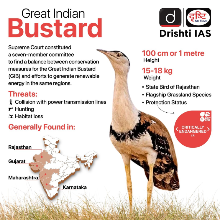
Project Great Indian Bustard (GIB) entered the fourth year of its captive breeding programme with the hatching of two new chicks at the Conservation Breeding Centre in Rajasthan, raising the total captive population to 70 birds.
Great Indian Bustard
- About: It is India’s most critically endangered bird and the State bird of Rajasthan, regarded as a flagship species representing the health of grassland ecosystems.
- GIB is one among four bustard species found in India, alongside the Lesser Florican, Bengal Florican, and Macqueen's Bustard.
- It is omnivorous and vulnerable to power line collisions due to lack of frontal vision.
- Distribution: It is one of the heaviest flying birds in the world, and mainly found in Rajasthan’s Thar Desert, with small populations in Gujarat, Maharashtra, Karnataka, and Andhra Pradesh.
- Conservation Status: IUCN Red List (Critically Endangered), CITES (Appendix I), Convention on Migratory Species (CMS) (Appendix I), and Wildlife (Protection) Act, 1972 (Schedule I).
- Conservation Efforts: Project GIB (launched in 2018) is a joint initiative of the Ministry of Environment, Wildlife Institute of India, and Rajasthan Forest Department.
- The species is covered under the Integrated Development of Wildlife Habitats scheme of MoEFCC to support recovery and conservation measures.
- A breeding centre was established in 2019 at Desert National Park, Jaisalmer by MoEFCC, Rajasthan Government and the Wildlife Institute of India (WII) to create a captive population and release birds into the wild.
| Read more: Great Indian Bustard (GIB) |


Place In News
National Chambal Sanctuary
The Supreme Court has taken suo motu cognisance to protect the fragile lotic ecosystem of the National Chambal Sanctuary from rampant and well-organized illegal sand mining by the "sand mafia."
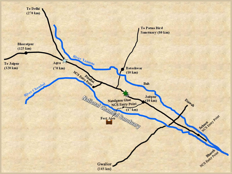
National Chambal Sanctuary
- About: The National Chambal Sanctuary, also known as the National Chambal Gharial Wildlife Sanctuary, is one of India's most ecologically significant riverine protected areas. It is the first and only tri-state protected area (Rajasthan, Madhya Pradesh, and Uttar Pradesh) in the country, spanning approximately 5,400 sq km along a 600 km stretch of the Chambal River (960-km).
- Biodiversity: It harbors nearly 90% of the world's remaining wild Gharial population and a significant number of endangered Ganges River Dolphins. Other key species are Marsh crocodile (mugger), Red-crowned roof turtle, Smooth-coated otter, striped hyena, and over 330 bird species e.g., Indian skimmer.
- It forms part of India's Project Crocodile initiative launched in 1975 to address the severe decline of crocodilian populations.
- Conservation Status: It is recognized as an Important Bird Area (IBA). It is a proposed Ramsar Site, a candidate for UNESCO World Heritage Site status, and classified as an IUCN Category IV protected area (habitat/species management area).
- Ecological Uniqueness: The Chambal River remains one of India's cleanest and most unpolluted rivers, creating a unique lotic ecosystem of deep channels, sandbanks, and ravines (beehad).
- Threats and Challenges: Critical threats include illegal sand mining, which, which degrades nesting grounds for sand-nesting species such as the gharial and certain turtles, alongside water extraction and illegal fishing that diminish both water levels and available prey.
| Read More: Illegal Sand Mining in National Chambal Sanctuary |


Rapid Fire
Balirajgarh Fort
The Archaeological Survey of India (ASI) has granted fresh approval for renewed scientific excavation at Balirajgarh Fort (officially the "Remains of Ancient Fort of Garh") in Madhubani district, Bihar.
Balirajgarh Fort
- About: It is a centrally protected national monument dating to around 200 BCE, offering insights into the Mithila region's early civilisation and its legendary links to King Bali (benevolent asura ruler from Hindu mythology).
- Part of the ASI's Patna Circle, it is one of Bihar's 71 protected sites of national importance.
- Cultural Sequence: The fortification dates primarily to circa 200 BCE during the Shunga period, with evidence suggesting earlier Iron Age origins.
- Excavations have revealed a 5-fold cultural sequence spanning the Northern Black Polished Ware (NBPW) phase (circa 700–200 BCE), followed by the Shunga, Kushan, Gupta, and Pala periods (up to the 12th century CE), indicating continuous habitation from early historic to early medieval times.
- Archaeological Findings: Previous excavations revealed structural remains, NBPW pottery, and artefacts, confirming the site as a major urban centre with massive boundary walls, elevated mounds, and defensive features.
- Excavation History: The site was first identified in 1884 by George Abraham Grierson, then Madhubani Sub-Divisional Magistrate.
- Systematic excavations occurred in 1962-63, 1972-73, and 2013-14, though the last was abandoned midway due to "environmental constraints and a high water table.
| Read More: Preservation of Cultural Heritage |


Rapid Fire
First Export of Assam’s Joha Rice
The Agricultural and Processed Food Products Export Development Authority (APEDA), under the Ministry of Commerce & Industry, facilitated the 1st export consignment of Geographical Indication (GI)-tagged Joha Rice from Assam to the United Kingdom and Italy.
Joha Rice
- About: Aromatic short-grain winter paddy cultivated in Assam and the Northeastern region of India, known for its distinct fragrance, fine grain texture and rich taste.
- Varieties: Around 22 traditional Joha rice varieties exist, with Kola Joha, Kunkuni Joha and Keteki Joha among the most popular.
- Key Features:
- Possesses anti-diabetic properties as it helps lower blood glucose levels and may prevent the onset of diabetes.
- Contains essential unsaturated fatty acids such as linoleic acid (omega-6) and linolenic acid (omega-3), which support metabolic and cardiovascular health.
- Has a balanced omega-6 to omega-3 fatty acid ratio, making it nutritionally superior compared to many conventional rice varieties.
- Rich in antioxidants, flavonoids and phenolic compounds such as oryzanol, ferulic acid and tocotrienol, which provide antioxidant, hypoglycaemic and cardio-protective benefits.
- Challenges: Despite its quality, Joha rice has low productivity and yield, leading to declining cultivation and the risk of some traditional varieties becoming extinct.

| Read more: Geographical Indication Tag - Drishti IAS |


