Important Facts For Prelims
Places in News-India
- 26 Sep 2021
- 60 min read
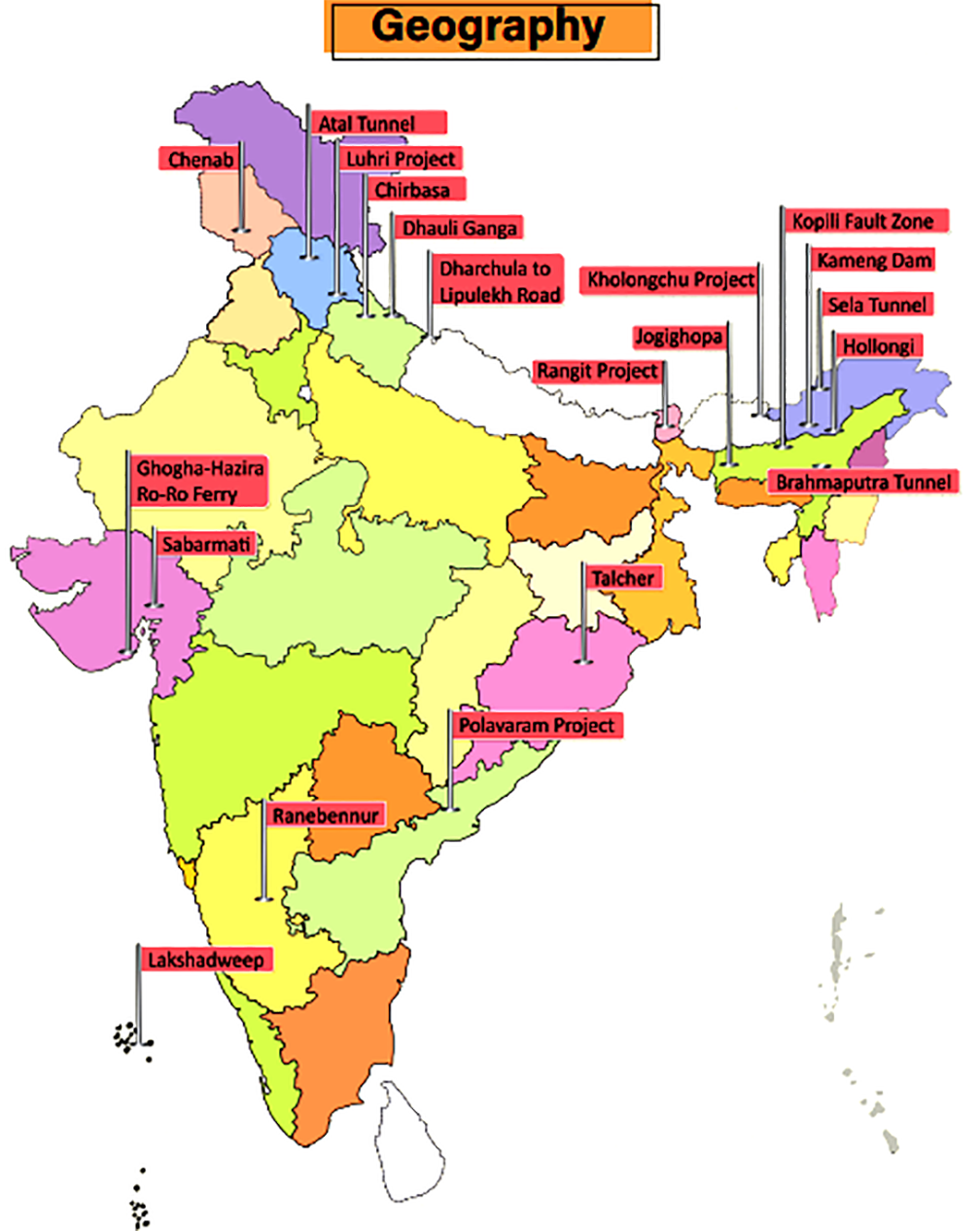
Atal Tunnel
Context
Atal Tunnel was inaugurated at Rohtang at an altitude of above 3,000 metres in Himachal Pradesh.
Key Points
- The 9.02 km-long tunnel, built by the Border Roads Organisation (BRO), is the world’s longest highway tunnel. It connects Manali to Lahaul-Spiti valley.
- The tunnel, also significant from the military logistics viewpoint, will provide better connectivity to the armed forces in reaching Ladakh.
Brahmaputra Tunnel
Context
The Central government has given in-principle approval for the construction of an underwater tunnel in the Brahmaputra river in Assam.
Key Points
- The tunnel will connect Gohpur (NH-54) with Numaligarh (NH-37) in Assam.
- The tunnel will be of strategic importance as it will provide round the year connectivity between the North-Eastern states of Assam and Arunachal Pradesh.
- The National Highways and Infrastructure Development Corporation Limited (NHAIDCL) has roped in the US-based firm Louis Berger for the same.
Chenab River
Context
The world’s highest railway bridge is being built over the Chenab river in Jammu and Kashmir.
About Chenab
- It is formed by the union of two headwaters, Chandra and Bhaga, which rise in the upper Himalayas in the Lahaul and Spiti districts of Himachal Pradesh.
- After receiving the Jhelum river near Trimmu, the Chenab empties into the Sutlej river, a tributary of the Indus river.
- The Chenab river was called Asikni in the Rigveda meaning that it was seen to have dark-coloured waters.
- Salal Dam is a 690 MW hydroelectric power project on Chenab river near Reasi, Jammu & Kashmir.
- The Ratle Hydroelectric Plant and Kiru Hydroelectric Power Project are proposed to be built over the Chenab.
Chirbasa
Context
Black Carbon research project has been established in Chirbasa.
About Chirbasa
- It is located on the banks of River Bhagirathi in the Gangotri National Park (Uttarakhand).
- This place at the altitude of 3,500 meters falls on the famous trekking route of Gomukh and Tapovan.
- Scientists have been monitoring black carbon in the region and especially the glaciers through two weather stations on the way to Gangotri glacier - namely Chirbasa and Bhojbasa (a few km ahead of Chirbasa).
Kameng Dam
Context
Recently, the Kameng Hydropower Project got fully commissioned.
About Kameng Project
- Situated in West Kameng District of Arunachal Pradesh, the Kameng Hydroelectric Project (600 MW) is a run-of-the-river scheme that will utilize the flows from Bichom and Tenga Rivers (both tributaries of the River Kameng).
- Kameng River
- It originates in Tawang district from the glacial lake below snow-capped Gori Chen mountain.
- It becomes a braided river in its lower reaches and is one of the major tributaries of the Brahmaputra River.
- The Kameng forms the boundary between East Kameng and West Kameng districts and is also the boundary between the Sessa and Eaglenest sanctuaries to its west and the Pakke Tiger Reserve to the east.
- Kameng Hydroelectric Project is the largest hydropower plant in the northeastern region.
Kholongchu Hydroelectric Project
Context
India and Bhutan have signed a pact for the construction of Kholongchhu joint venture hydroelectric project in Bhutan.
India-Bhutan Hydro Projects
- The 600 MW run-of-the-river project, Kholongchhu, is located on the lower course of the Kholongchhu river in Trashiyangtse district in eastern Bhutan.
- Currently, four hydroelectric projects of bilateral cooperation totalling over 2,100 MW, are operational in Bhutan. These include:
- Chukha Hydro Electric project
- Kurichu Hydro Electric project
- Tala Hydro Electric Project
- Mangdechhu HydroElectric Project
- Besides, both sides are also in process of expediting the completion of other ongoing projects including the Punatsangchhu Project.
Luhri Hydropower Project
Context
Recently, the Union Cabinet approved the building of the Luhri Hydropower Project.
About
- The Luhri Project is situated in Shimla and Kullu districts of HImachal Pradesh.
- It is being implemented by the Satluj Jal Vidyut Nigam Limited (SJVNL) on Build-Own-Operate-Maintain (BOOM) basis.
Rangit Power Project
Context
The stressed asset Rangit-IV Hydroelectric Project of Jal Power Corporation Ltd (JPCL) has been handed over to the National Hydro Power Corporation (NHPC) Ltd.
About
- Rangit dam is a run-of-the-river power project on the Rangit river, a major tributary of the Teesta river in Sikkim.
- The Rangit river arises from the Talung glacier and it meets the Teesta river at Melli in Sikkim itself.
Dharchula to Lipulekh Road
Context
The Border Roads Organisation (BRO) has completed the construction of a road from Dharchula to Lipulekh along the China Border, famously known as Kailash-Mansarovar Yatra Route.
About the Road
- The road has been built from Ghatibagar in Dharchula to Lipulekh near the border with China.
- The tough Himalayan terrain beginning from Mangti camp near Tawaghat to Gunji in Vyans valley, and Indian security posts situated near Indo-China border, are now accessible by a concrete road.
- The road ends at the 17,000 feet high Lipulekh pass. From there, Mount Kailash is located around 97 km north of the pass in Tibet.
- The Lipulekh pass, close to the tri-junction of India-China-Nepal, is the lowest point in this section of the high Himalayas.
Dhauli Ganga River
Context
Recently, Dhauli Ganga river in Uttarakhand witnessed glacial floods.
About Dhauli Ganga
- Originating in the vicinity of the Niti Pass (Uttarakhand), the Dhauli Ganga flows in a meandering course, which takes it through the Nanda Devi National Park.
- Dhauli Ganga, which merges with Alaknanda, is one of the several tributaries of the Ganga, as the holy river flows down from the Himalayas and snakes its way through the plains.
- Dhauli Ganga is joined by the Rishi Ganga river at Raini where the disaster at the power project dam took place.
- The river takes a V turn and continues to flow in the opposite direction, toward north, as Dhauli Ganga, through Tapovan, until it is joined by Alaknanda river at Vishnuprayag near Joshimath.
- Dhauli Ganga is one of the important tributaries of Alaknanda, the other being the Nandakini, Pindar, Mandakini and Bhagirathi.
Ghogha - Hazira Ro-Ro Ferry
Context
Last year, the Prime Minister virtually inaugurated the Ghogha-Hazira Ro-Pax ferry service in Gujarat.
About Ghoga-Hazira ferry
- The ferry moves between Ghogha (a fishing hamlet and an old port) and Hazira (a commercial greenfield port).
- The service was launched to bridge the Gulf of Khambhat by providing a sea route to passengers travelling to and fro between Bhavnagar (located on the western side of the Gulf) and South Gujarat (on the east).
Hollongi
Context
Airports Authority of India (AAI) planned to develop a greenfield airport at Hollongi.
About Hollongi
- Hollongi is located in Arunachal Pradesh. It lies south of the state capital Itanagar.
- This airport, when operational, will service Arunachal Pradesh's capital Itanagar. The closest airport to the state capital is currently Lilabari airport in Assam, situated 80 kilometres away.
Jogighopa
Context
The Union Minister for Road Transport and Highways has laid the foundation stone for the country's first Multi-Modal Logistics Park (MMLP) at Jogighopa in Assam.
About Jogighopa
- Jogighopa is a town located on the northern bank of the Brahmaputra River. It has a combined road-rail bridge, called Naranarayan Setu, over the Brahmaputra river.
- The city has the remains of the five rock-cut caves, examples of Salasthambha period architecture being preserved by the Archaeological Survey of India (ASI).
- Under its MMLP project, the development includes railway sidings, container terminals, warehousing, non-cargo processing, a truck terminal, common facilities, support infrastructure and equipment.
- With this, Jogighopa will become India’s gateway to South-East Asia as well as the rest of the North-East with road, rail, waterways and air transport facilities under the MMLP.
- The MMLP at Jogighopa will be the country’s first international Multi-Modal Logistic Park under the Bharatmala Project of the Ministry of Road Transport and Highways.
Kopili Fault Zone
Context
The Kopili Fault Zone closer to Himalayan Frontal Thrust in Assam recently witnessed a powerful earthquake.
About Kopili Fault Zone
- The Kopili fault zone is a 300 km long and 50 km wide lineament (linear feature) extending from the western part of Manipur up to the tri-junction of Bhutan, Arunachal Pradesh and Assam.
- The area is seismically very active, falling in the highest Seismic Hazard Zone V associated with collisional tectonics where Indian plate subducts beneath the Eurasian Plate.
- Subduction is a geological process in which one crustal plate is forced below the edge of another.
- Squeezed between the subduction and collision zones of the Himalayan belt and Sumatran belt, the North East is highly prone to earthquake occurrences.
- A tectonic depression filled up by the alluvium of the Kopili river and its tributaries, the Kopili fault zone has witnessed many seismic activities in the past including the 1869 earthquake (7.8 magnitude) and the 1943 earthquake (7.3 magnitude).
Lakshadweep
Context
The entire Lakshadweep group of islands has been declared as an organic agricultural area under the Participatory Guarantee System (PGS) of India.
About Lakshadweep
- Lakshadweep is the first Union Territory to become 100% organic as all farming is carried out without the use of synthetic fertilisers and pesticides, etc. Earlier in 2016, Sikkim became India’s first 100% organic State.
- It is an archipelago of 36 islands in the Arabian Sea, located off of the mainland's southwestern coast.
- The Aminidivi subgroup of islands (consisting of Amini, Keltan, Chetlat, Kadamat, Bitra, and Perumal Par) and the Laccadive subgroup of islands (comprising mainly Androth, Kalpeni, Kavaratti, Pitti, and Suheli Par) have a submarine connection between them through Pitti Bank.
- Together with Minicoy Island, a lonely atoll located at the southern end of the 200-km-broad Nine Degree Channel, they form the Coral Islands of India in the Arabian Sea.
Polavaram Irrigation Project
Context
The Polavaram Project is an under-construction multi-purpose irrigation project on the Godavari river in Andhra Pradesh.
About Polavaram
- Polavaram or Prolavaram is a village in the West Godavari district of Andhra Pradesh.
- The Papi Hills and Polavaram Project are the major landmarks near the village. The project has been accorded national project status by the Government of India.
- This area was under the rule of Kamma kings of Musunuri Nayaks. Kamma king Musunuri Prolayya, in 1330 donated Polavaram village to Brahmins. Polavaram means, Prola is Prola and Varam is donation.
- The Polavaram Project has been a contentious issue in various terms like its financing, rehabilitation of affected people and affected areas of states other than Andhra Pradesh, i.e. Odisha and Telangana.
Ranebennur
Context
One Common Facility Centre for wool processing has been proposed to be established at Ranebennur (Karnataka).
About Ranebennur
- Ranebennur is a city in Haveri district in Karnataka. It is home to a rich commodity market. Commodities like cotton yarn, cottonseed, oilseeds, red chilli, betel nut, and betel leaf are traded.
- One of Karnataka's most important rivers – the Tungabhadra – flows along the southern border of Ranebennur taluk.
- Another river, Kumadvathi, which originates from Madagh Masur Lake, enters Ranebennur, and joins the Tungabhadra river.
- Ranebennur Blackbuck Sanctuary is home to blackbuck, Great Indian Bustard and wolves. The Great Indian Bustard was last spotted in 2005 and may have become locally extinct.
Sabarmati River
Context
Ahmedabad Municipal Corporation has been working towards development of Sabarmati riverfront.
About Sabarmati river
- The Sabarmati river is a monsoon-fed river that flows north-south through Ahmedabad, bisecting the city into its western and eastern halves.
- It is one of the major west-flowing rivers that originates in the Aravalli Range of the Udaipur District of Rajasthan. It meets the Gulf of Khambhat of the Arabian Sea.
- The river traverses three geomorphic zones: rocky uplands, middle alluvial plains, and lower estuarine zone.
- The Dharoi dam is located on this river.
Sela Tunnel
Context
Sela tunnel is an under-construction road which will ensure all-weather connectivity between Assam and Arunachal Pradesh.
About Sela tunnel
- It is located at a height of 13,700 feet and is being executed by Border Roads Organisation (BRO).
- The tunnel once complete will provide all-weather connectivity to Tawang and forward areas as it is going to avoid all the avalanche prone and snowfall areas.
- It will reduce the travelling time from Tezpur to Tawang by more than an hour and boost tourism and related economic activities in the region.
- The tunnels would ensure that the 171 km road between Bomdila and Tawang remains accessible in all weather conditions.
Talcher
Context
India's first coal gasification-based fertiliser plant is being set up at Talcher.
About Talcher
- Talcher (Odisha) is situated on the bank of the river Brahmani.
- In the 14th century, Panchdiha Chasa who were mainly a farmer community came to this fertile area and started living here. The King of Talcher Padmanabha Birabara Harichandan renamed the state as Talcher after the name of the family Goddess Taleswari.
- Talcher is also named as the City of Black Diamond or Coal City of Odisha and is the largest coalfield of India.
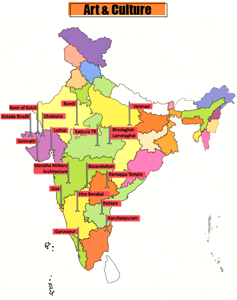
Six Heritage Sites Added to Tentative List of UNESCO
In news
- Six sites have been added to India’s tentative list of UNESCO World Heritage Sites (WHS). A Tentative List is an inventory of those properties which each State/Country party intends to consider for nomination further in WHS.
- The six sites are:
- Ganga ghats in Varanasi,
- Temples of Kancheepuram in Tamil Nadu,
- Satpura Tiger Reserve in Madhya Pradesh,
- Maratha military architecture in Maharashtra,
- Hire Bengal megalithic site in Karnataka and
- Bhedaghat-Lameta Ghat of Narmada Valley in Madhya Pradesh.
Architectural Heritage of Bundi
In news
A recent webinar series by the Ministry of Tourism, titled ‘Dekho Apna Desh’, focused on the architectural heritage of Bundi, Rajasthan.
About Bundi
- Sukh Mahal, Raniji ki Baori, Taragarh Fort, 84 Pillared Cenotaph, Garh Palace, Badal Mahal, Chhatr Palace, etc. are some of the notable pieces of architectural heritage of Bundi.
- Bundi was once ruled by the Hada Chauhans. Many historians claim that it was once the capital of the great Hadoti Kingdom, which was renowned for its art and sculpture.
- The Hadoti region is named after the Hada Chauhans, who ruled this area around Kota and Bundi.
- In ancient times, the area around Bundi was apparently inhabited by various local tribes, of which the Parihar Meena and Bhil Meena were prominent.
- Later, the region was governed by Rao Deva, who took over Bundi from Jaita Meena in 1242, renaming the surrounding area as Haravati or Hadoti.
- For the next two centuries, the Hadas of Bundi were the vassals of the Sisodias of Mewar and ruled by the title of Rao until 1569, after Emperor Akbar.
Dholavira
In news
Dholavira, the archaeological site of a Harappan-era city, received the UNESCO World Heritage Site tag, recently.
About Dholavira
- The ancient city of Dholavira, the southern centre of the Harappan Civilization, is situated on the arid island of Khadir in the State of Gujarat.
- Occupied between 3000-1500 BCE, it is one of the best-preserved urban settlements from the period in Southeast Asia, comprising a fortified city and a cemetery.
- While Dholavira became the fourth site from Gujarat and 40th from India to make the list, it is the first site of the ancient Indus Valley Civilisation (IVC) in India to get the tag.
- Other 3 sites from Gujarat in the WHS include Champaner in Pavagadh, Rani Ki Vav in Patan and the Historic City of Ahmedabad.
Goa
In news
The Government of Goa has released a short film on Chhatrapati Shivaji on the occasion of the anniversary of the Maratha king’s coronation day highlighting the history of Goa and Shivaji’s role in fighting the Portuguese.
About Goa
- Goa lies within the region known as the Konkan and is geographically separated from the Deccan highlands by the Western Ghats.
- It is India's smallest state by area and has the highest GDP per capita among all Indian states.
- Major rivers are Zuari, Mandovi, Terekhol, Chapora, Galgibag, etc.
- The Goa, Daman and Diu Official Language Act, 1987 makes Konkani in the Devanagari script the sole official language of Goa, but provides that Marathi may also be used "for all or any of the official purposes".
Guruvayur, Kerala
In news
A Tourist Facilitation Centre facility was constructed under the project “Development of Guruvayur, Kerala” - under PRASAD Scheme of the Ministry of Tourism.
About Guruvayur
- This place is famous for Guruvayur temple dedicated to Lord Guruvayoorappan, a form of Lord Vishnu. The temple is also known as Guruvayur Sri Krishna Temple.
- The famous festivals of the temple are Guruvayur Ekadashi, Chembai Sangeetholsavam, etc.
- The temple tank (pond) on the northern side of the temple is called Rudratheertham.
- In the 14th century Tamil literature 'Kokasandesam', references about a place called Kuruvayur can be found.
Kadapa, Andhra Pradesh
Context
A rare inscription dating back to the Renati Chola reign (8th century CE) has been unearthed in a remote village of the Kadapa district of Andhra Pradesh.
About Kadapa
- The city is surrounded on three sides by the Nallamala and Palkonda Hills.
- Kadapa has been under different rulers in its history, including the Nizams and Cholas, the Vijayanagara Empire and the Kingdom of Mysore.
- The discovered inscription was written in archaic Telugu. It seems to throw light on the record of a gift of six Marttus (a measuring unit) of land gifted to a person Sidyamayu, one of the Brahmins serving the temple at Pidukula village.
Kakatiya Rudreshwara Temple
In news
The Kakatiya Rudreshwara Temple, also known as the Ramappa Temple, in Telangana was recently inscribed as a UNESCO World Heritage Site.
About Ramappa Temple
- The Ramappa temple is named after its sculptor Ramappa. Constructed in 1213 CE under the Kakatiya dynasty, it took almost 40 years to be completed.
- The temple was built during the rule of the Kakatiya king Gajapati Deva under the supervision of Recherla Rudra Reddy, who was the chief of the Kakatiya army.
- It is the first and only monument from Andhra Pradesh and Telangana to make it to the list of WHS.
- What really sets the temple apart are its ‘floating bricks’ that were used to build the ‘Shikara’ roof of the temple.
- The bricks are so light that they can float on water.
- The density of the bricks is between 0.85 to 0.9 grams per cubic centimetre, whereas the density of water is 1 g/cc.
- Any usual brick has a density of around 2.2 g/cc.
Kotada Bhadli
In news
Recently, a pottery-based study has found that dairy products were being produced by the Harappans as far back as 2500 BCE.
About the finding
- Kotada Bhadli is a small village settlement, measuring about 3.11 ha, and located at the confluence of two rivers.
- The findings are based on an analysis of the absorbed lipid residues in unglazed ceramic vessels.
- The significance of the finding lies in the revelation that cheese was very likely made and consumed in the subcontinent during what is known as the Mature Harappan period.
- This would make it the earliest evidence of cheese-making in the region.
- In 2018, a study used carbon dating of lipid residues in pottery from the Dalmatian Coast of Croatia to establish the practice of dairy processing in the Mediterranean over 7,000 years ago in 5200 BCE.
Lothal
In news
In order to showcase the maritime heritage and history of India, a National Maritime Heritage Complex (NMHC) will be developed in the Lothal region of Gujarat. The NMHC will have National Maritime Heritage Museum, Heritage Theme Park, and Lighthouse Museum.
About Lothal
- Lothal was one of the southernmost cities of the ancient Indus Valley Civilization located in Gujarat. It was excavated during 1955-1960 by S R Rao.
- According to the Archeological Survey of India, Lothal has the world’s earliest known dock, which connected the city to an ancient course of the Sabarmati river on the trade route between Harappan cities in Sindh and the peninsula of Saurashtra.
- Lothal was a vital and thriving trade centre in ancient times, with its trade of beads, gems, and valuable ornaments reaching the far corners of West Asia and Africa.
- The most unique method of disposal of the dead was found at Lothal – twin burial, i.e. the burial of two individuals together.
New Anubhava Mantapa in Basavakalyan
In news
The foundation stone for the ‘New Anubhava Mantapa’ was laid in Basavakalyan. It will be built in the Kalyana Chalukya style of architecture.
About Basavakalyan
- Basavakalyan was ruled by Western Chalukyas, Kalachuris of Kalyani, Yadavas of Devagiri, Kakatiyas, Delhi Sultanate, Bahamani Sultanate (Bidar, Gulbarga), Bidar Sultanate, Bijapur Sultanate, Mughals and Hyderabad Nizams.
- It was the royal capital of the Western Chalukya (Kalyani Chalukyas) dynasty from 1050 to 1195. Someshvara I (1041–1068) made Kalyan his capital, recognised as Kalyani Chalukyas to differentiate it from Badami Chalukyas.
- Kalachuris of Kalyani succeeded Kalyani Chalukyas and continued Kalyani as their capital.
- During the 12th century, the Kalachuris of Kalyani King Bijjala (1156–1167) assumed the throne, and Basaveshwara was appointed as his prime minister.
- Basavakalyan Fort was constructed by Chalukyas.
Rann of Kutch
In news
The Ministry of Tourism organized a Conference on Destination Management and Community Participation in 2020 at Rann of Kutch, Gujarat.
About Rann of Kutch
- The Rann of Kutch is a large area of salt marshes that spans the border between India and Pakistan, located mostly in Gujarat.
- Many rivers originating in Rajasthan and Gujarat flow into the Rann of Kutch, including the Luni, Bhuki, Bharud, Nara, Kharod, Banas, Saraswati, Rupen, Bambhan, and Machchhu.
- Kori Creek and Sir Creek are the tidal creeks which are part of the Indus river delta located at the western end of the Great Rann.
- A tidal creek refers to a small waterway that contains mixed waters (saline and fresh). It is the part of a stream that is affected by the ocean tides. During low tides, the creeks may dry up forming a muddy channel. On the other hand, during high tides, they have large amounts of water.
- Tribal hamlets with cylindrical mud bhungas (huts) are the epicenter for Kutchi embroidery, tie and dye, leatherwork, pottery, bell metal craft and the famous Rogan painting.
- The Rann of Kutch is the only large flooded grasslands zone in the Indomalayan realm.
- The IVC city of Dholavira, the largest IVC site in India, is located in the Rann of Kutch. This city was built on the Tropic of Cancer, possibly indicating that Dholavira's inhabitants were skilled in astronomy.
- The Rann of Kutch also contained the industrial site of Khirasara, where a warehouse was found.
Somnath, Gujarat
In news
The project - Development of Pilgrimage Amenities at Somnath, Gujarat - was inaugurated recently.
About Somnath
- Somnath (district name Gir Somnath) is very famous for the Somnath Temple, the first Jyotirlinga of Lord Shiva among the twelve jyotirlingas of India, and Gir Sanctuary, the only abode to Asiatic lions.
- Gir is famous for its Kesar Mango, Siddi’s folk dance “Dhamal” and Gir National Park and Sanctuary.
- Siddi people, who are originally from Africa, inhabit Jambur village, also known as Mini Africa of India.
- According to popular tradition documented by J. Gordon Melton, the first Shiva temple at Somnath is believed to have been built at some unknown time in the past.
- The second temple is said to have been built at the same site by the Yadava kings of Vallabhi around 649 CE. In 725 CE, Al-Junayd, the Arab governor of Sindh is said to have destroyed the second temple as part of his invasions of Gujarat and Rajasthan.
- The Gurjara-Pratihara king Nagabhata II is said to have constructed the third temple in 815 CE, a large structure of red sandstone.
- In 1024, during the reign of Bhima I, the prominent Turkic Muslim ruler Mahmud of Ghazni raided Gujarat, plundering the Somnath temple and breaking its Jyotirlinga.
- During its 1299 invasion of Gujarat, Alauddin Khalji's army, led by Ulugh Khan, defeated the Vaghela king Karna, and sacked the Somnath temple.
- The present temple was reconstructed in the Chalukya style of Hindu temple architecture and completed in May 1951.
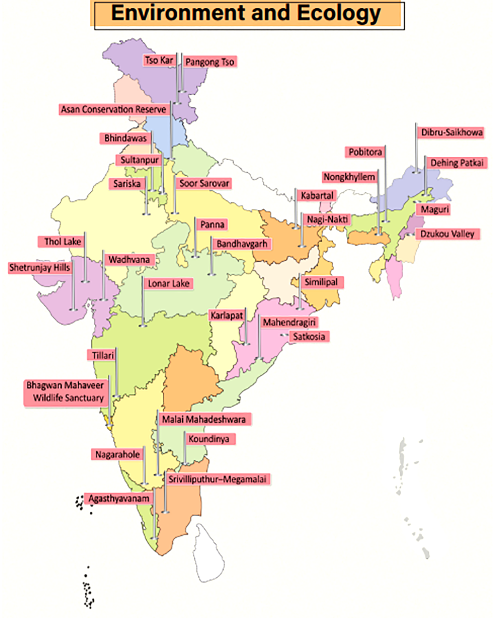
Agasthyavanam Biological Park
Context
A recent initiative titled ‘Vanika’ by the Kerala Forest and Wildlife Department has enabled the tribals living in the Agasthyavanam Biological Park to sell their agriculture and forest produce online.
Key Points
- Established in 1997, Agasthyavanam Biological Park is a wildlife sanctuary near Thiruvananthapuram, Kerala.
- The Park has been named after the mesmerizing Agasthyamalai Agasthyakoodam Peak that can be seen at a distance.
- The Park is contiguous to the Neyyar and Peppara Wildlife Sanctuaries. The park forms part of a larger protected area of Agasthyamalai Biosphere Reserve.
Bandhavgarh Tiger Reserve
Context
India’s first hot air balloon wildlife safari in a tiger reserve was launched recently in Bandhavgarh Tiger Reserve.
Key Points
- Bandhavgarh Tiger Reserve is located in the eastern Satpura hill range of Umaria and Katni districts of Madhya Pradesh. Reference to this protected area is also found in the Narad Panch Ratna and Shiva Samhita Puran.
- Bandhavgarh was declared a National Park in 1968 and a Tiger Reserve in 1993. It is spread over Vindhya hills in Madhya Pradesh where topography varies from steep ridges, undulating, forest to open meadows.
- Bandhavgarh National Park consists of mixed vegetation ranging from tall grasslands to thick Sal forest and so is the perfect habitat for a variety of animals and birds.
Bhagwan Mahaveer Wildlife Sanctuary
Context
Raising serious environmental concerns, the Central Empowerment Committee of the Supreme Court has red-flagged Goa rail projects cutting through Bhagwan Mahaveer Wildlife Sanctuary and the Mollem National Park.
Key Points
- Bhagwan Mahaveer Wildlife Sanctuary (BMWS), located on the foothills of the Western Ghats, is the largest of Goa’s four protected wildlife areas and contains within it the Mollem National Park (MNP).
- It is also home to the famous Dudhsagar waterfall and the Devil’s Canyon.
- Vegetation: West Coast tropical evergreen forests, West Coast semi-evergreen forests and moist deciduous forests.
- Fauna: Deer, sambar, spotted deer, hog, mouse deer and barking deer, tiger, leopard cat, panther, lesser Indian civet, wild dog, hyena, sloth bear, jackal, bonnet macaque, slender loris, scaly anteater, giant squirrel, flying squirrel etc.
- Flora: Primary species of trees found here include Terminalia, Lagerstroemia (crepe myrtle), Xylia and Dalbergia (timber trees).
Dehing Patkai Wildlife Sanctuary
Context
The Assam government has decided to upgrade Dehing Patkai Wildlife Sanctuary into a National Park.
About
- Post upgradation, Dehing Patkai will be the sixth National Park in Assam - the other five being Kaziranga, Nameri, Manas, Orang and Dibru-Saikhowa.
- Dehing Patkai was declared a Wildlife Sanctuary in 2004 and is home to a vast variety of flora and fauna.
- It is located within the larger Dehing Patkai Elephant Reserve, which spreads across the coal- and oil-rich districts of Upper Assam (Dibrugarh, Tinsukia and Sivasagar) and is believed to be the last remaining contiguous patch of lowland rainforest area in Assam.
- Fauna: Rare fauna found in the region include Chinese pangolin, flying fox, wild pig, sambar, barking deer, gaur, serow and Malayan giant squirrels.
- It is the only sanctuary in India that is home to seven different species of wild cats - tiger, leopard, clouded leopard, leopard cat, golden cat, jungle cat and marbled cat.
- It has the highest concentration of the endangered White Winged Wood Duck.
- Flora: Dehing Patkai is a deciduous rainforest interspersed with semi-evergreen and lush green flora.
Dibru-Saikhowa National Park
Context
The decision of Oil India Ltd. to drill seven wells inside the Dibru-Saikhowa National Park has raised concerns.
About
- Dibru-Saikhowa is a National Park as well as a Biosphere Reserve situated on the south bank of the river Brahmaputra in the extreme east of Assam.
- It is bounded by Lohit and Brahmaputra rivers on the north and the Dibru river on the southern side.
- Forests: Semi-evergreen forests, deciduous forests, littoral and swamp forests and patches of wet evergreen forests.
- The largest Salix swamp forest of North East India is located inside this reserve.
- Fauna: Tiger, Elephant, Leopard, Small Indian Civet, Gangetic Dolphin, Slow Loris, etc.
- It is identified as an Important Bird and Biodiversity Area.
Dzukou Valley
Context
A wildfire blazed the Dzukou Valley straddling the Manipur-Nagaland border.
About Dzukou Valley
- The Dzukou Valley is located at the border of Nagaland and Manipur. Located just behind the Japfu Peak, it is one of the most popular trekking spots in the North East.
- Dzukou valley and Japfu peak are located adjacent to the Pulie Badze Wildlife Sanctuary (Nagaland).
- Home to the Angami people, the valley is also famous for its wide range of flowers in every season.
- Fauna: It is home to Blyth's tragopan, which is the state bird of Nagaland. Asian golden cat, the Hoolock Gibbon, the Dzukou Valley horned toad, the capped langur, the stump-tailed macaque, and the serow.
- Flora: The valley is famous for its wide range of flowers in every season but the most famous one is the Dzukou Lily and it is found only in this valley, several rhododendron species, plants such as the Aconita nagaram.
Karlapat Wildlife Sanctuary
Context
Six elephants died of haemorrhagic septicaemia in Karlapat Wildlife Sanctuary, recently.
About Karlapat Wildlife Sanctuary
- The sanctuary is located in Kalahandi district, Odisha.
- Vegetation: Dry Deciduous Forest.
- Fauna: Leopard, gaur, sambar, nilgai, barking deer, mouse deer, soft claws ottawa, etc.
- Flora: Sal, Bija, Bamboo, medicinal plants, etc.
- Phurlijharan waterfall is located close to the sanctuary.
Koundinya Wildlife Sanctuary
Context
Herds of wild elephants from the forests abutting the Koundinya wildlife sanctuary and Tamil Nadu border often stray out much to the concern of the people and forest officials.
About Koundinya Wildlife Sanctuary
- Kaundinya is located in Palamner-Kuppam forest ranges of Chittoor district of Andhra Pradesh. The sanctuary is the only home for Asiatic elephants in the State of Andhra Pradesh.
- This Sanctuary comes under Project elephant - a country wide Elephant Conservation Project taken up by Government of India.
- The sanctuary has dry deciduous forests with thorny shrubs interspersed with trees.
- The sanctuary is situated in a region where the Kolar Plateau ends and slopes down into the plains of Tamil Nadu creating many valleys and ghats.
- Fauna: The vulnerable yellow-throated bulbul is found in the sanctuary.
- Some of the other animals found in the sanctuary are sloth bear, panther, cheetal, chowsingha, sambar, porcupine, wild boar, jungle cat, jackal, jungle fowl, starred tortoise and slender loris.
- Flora: Some of the important flora found include Albizia amara, Acacia, Lagerstroemia, Ficus, bamboo, and a species that is a regeneration of Santalum album.
Maguri Beel
Context
Recently, Mandarin ducks were sighted in the Maguri-Motapung beel after a century.
About Maguri beel
- Maguri (local term for walking catfish) Beel is a wetland and lake located near to Dibru-Saikhowa National Park in Tinsukia district in Assam.
- It is located on the south bank of the Dibru River and it connects the Dibru River through a small channel and finally meets the Brahmaputra river.
Mahendragiri Hill
Context
The Odisha government has proposed the state's second biosphere reserve in the southern part of Mahendragiri, a hill ecosystem having rich biodiversity.
About
- The area of the proposed Mahendragiri Biosphere Reserve is spread over Gajapati and Ganjam districts in the Eastern Ghats.
- When notified, it will become Odisha’s second biosphere reserve. The 5,569-square kilometre Similipal Biosphere Reserve is Odisha’s first such reserve and was notified May 20, 1996.
- Mahendragiri, with an elevation of 1,501 metres, is a hill in Odisha, situated along the Eastern Ghats. It is one of the highest points of Eastern Ghats.
- Mahendragiri is inhabited by the Soura people, a Particularly Vulnerable Tribal Group (PVTG).
Malai Mahadeshwara Hills Wildlife Sanctuary
Context
The Malai Mahadeshwara Hills Wildlife Sanctuary has been proposed to be declared as a Tiger Reserve. When notified, it will become Karnataka’s sixth Tiger Reserve.
About
- The proposed Tiger Reserve with a core area of about 670 km2 is spread across Malai Mahadeshwara Reserve Forest, Hanur Reserve Forest and Yediyarahalli Reserve Forest. The proposed Tiger Reserve is also part of the notified Mysore Elephant Reserve.
- The MM Hills WLS is contiguous to BRT (Biligiri Ranganathaswamy Temple) Tiger Reserve on one side and Sathyamangalam Tiger Reserve in Tamil Nadu on the other.
- The Cauvery Wildlife Sanctuary also borders it, thus providing a contiguous forest cover of over 3,500 km2 that can act as a sink to absorb surplus tiger population and help increase their numbers.
- There is an abundance of species like gaur, sambar, chital, four-horned antelope, wild boar, etc. The grizzled giant squirrel (IUCN Status: Near Threatened) is also found here. There are about 285 bird species documented in this landscape as per a 2014 survey.
Nagarahole National Park
Context
The Karnataka Forest Department plans to place a traffic monitoring mechanism for roads adjacent to Nagarhole National Park (NNP) to ensure better compliance of forest laws by motorists and minimise road kills.
About NNP
- NNP is also known as Rajiv Gandhi National Park. It is located in Kodagu and Mysore districts of Karnataka.
- Bandipur, Mudumalai and Wayanad Wildlife Sanctuaries are adjacent to NNP.
- Nagarahole river flows through the park and gradually joins the Kabini river which also is a boundary between Nagarahole and Bandipur.
- Fauna: Chital (spotted deer), Indian mouse deer, gaur, stripe-necked and ruddy mongooses, grey langur, bonnet macaque, Asian wild dog, leopard, tiger, etc.
Nagi-Nakti Bird Sanctuaries
Context
Recently, Bihar’s first state-level bird festival ‘Kalrav’ was organised at the Nagi-Nakti bird sanctuaries in the Jamui district.
About Nagi-Nakti Bird Sanctuaries
- The Nagi Dam and Nakti Dam are two sanctuaries so close to each other that they can be taken as one bird area.
- The Nagi-Nakti Bird Sanctuaries have been the home of a wide variety of indigenous species of birds and of migratory birds that turn up during the winters from places like Eurasia, Central Asia, the Arctic Circle, Russia and Northern China.
- Major avifauna found here include Indian Courser, Indian Sandgrouse, Yellow-wattled Lapwing and Indian Robin.
New Ramsar Sites in 2020
Context
In 2020, five sites were recognised as Wetlands of International Importance under the Ramsar Convention.
New Sites
- Asan Conservation Reserve
- The Asan Conservation Reserve is a man-made wetland situated near Herbatpur, a small town at the Uttarakhand-Himachal border in Dehradun.
- Kabartal Wetland
- Bihar has got Kabartal as its first Ramsar site in 2020. Also known as Kanwar Jheel, it is the largest ox bow lake comprising the floodplain of Burhi Gandak river.
- Lonar Lake
- Lonar lake, situated in the Deccan Plateau’s volcanic basalt rock, was created by the impact of a meteor 35,000 to 50,000 years ago.
- The lake is part of Lonar Wildlife Sanctuary which falls under the unified control of the Melghat Tiger Reserve (MTR).
- Soor Sarovar Lake
- It is also known as Keetham lake situated within the Soor Sarovar Bird Sanctuary, which was declared as a bird sanctuary in the year 1991.
- This lake is situated alongside the river Yamuna in Agra, Uttar Pradesh.
- Tso Kar Wetland
- Tso Kar is a high altitude wetland located 4,500 metres above sea level in the Changthang region of Ladakh.
- It’s a unique site where two lakes with contrasting chemical composition - freshwater Startsapuk Tso and the larger hyper saline Tso Kar - exist closely.
- It is called Tso Kar, meaning white lake, because of the white salt efflorescence found on the margins due to the evaporation of highly saline water.
New Ramsar Sites in 2021
Context
In August 2021, four more Indian sites - two each from Haryana and Gujarat - were recognised as Wetlands of International Importance under the Ramsar Convention. Thus, the total number of Ramsar Sites in India reached 46.
New sites
- Bhindawas Wildlife Sanctuary
- Located in Jhajjar, it is a human-made freshwater wetland. It is also the largest in Haryana. Over 250 bird species use the sanctuary throughout the year as a resting and roosting site.
- Sultanpur National Park
- It is one of the two National Parks in the state of Haryana. The other NP in Haryana is Kalesar National Park.
- Thol Lake Wildlife Sanctuary
- One of the most popular birding hotspots of Gujarat, the Thol Lake Wildlife Sanctuary is located near Ahmedabad..
- Wadhvana Wetland
- Located in Vadodara (Gujarat), Wadhvana Wetland is internationally important for its bird life as it provides wintering ground to migratory water birds, including over 80 species that migrate on the Central Asian Flyway.
Nongkhyllem Wildlife Sanctuary
Context
India’s first bamboo-dwelling bat (Eudiscopus denticulus) with sticky discs was recorded in Nongkhyllem Wildlife Sanctuary.
About
- This sanctuary, in Ri Bhoi district of Meghalaya, is one of the best protected areas in the Northeast. It falls in the Eastern Himalayan biodiversity hotspot.
- It is drained by rivers and streams like Umran, Umming, Umpurthih and Umtru. There is a natural lake named Birbah in the southern part of the Sanctuary.
- The sanctuary supports different species of fauna such as Royal Bengal Tiger, Clouded Leopard, Indian Bison, and Himalayan Black Bear, etc.
- Among the birds, the rare species which can be spotted here are Manipur Bush Quail, Rufous Necked Hornbill and Brown Hornbill.
- Other Protected Areas in Meghalaya include Siju Wildlife Sanctuary; Narpuh Wildlife Sanctuary; Baghmara Pitcher Plant Sanctuary; and Nokrek National Park.
Pangong Tso
Context
The lake in Ladakh was witness to the face-off between Indian and Chinese forces.
About Pangong Tso
- Pangong Lake, situated at a height of almost 4,350m, is the world’s highest saltwater lake.
- During summer, the Bar-headed goose and Brahmini ducks are commonly seen here.
- The region around the lake supports a number of species of wildlife including the kiang and the marmot.
- The lake hosts large quantities of fish, especially Schizopygopsis stoliczka and Racoma labiata.
- Extending to almost 160 km, one-third of the Pangong Lake lies in India and the other two-thirds in China.
- An Inner Line Permit is required to visit the lake as it lies on the Sino-Indian Line of Actual Control.
Panna Tiger Reserve
Context
Panna Tiger Reserve has been included in the World Network of Biosphere Reserves (WNBR) under Man and the Biosphere (MAB) Programme. India now has 12 out of 18 of its Biosphere Reserves listed in the MAB Programme.
About Panna Tiger Reserve
- Panna TR is located in the Vindhyas nearer to the confluence of the Deccan Peninsula, Upper Gangetic Plain and Semi-Arid Gujarat Rajputana reflecting the influence of three bio-geographic regions.
- Panna National Park was formed in 1981 and declared a Tiger Reserve in 1994. In 2011, Panna was designated as a Biosphere Reserve by the Union Ministry of Environment and Forests.
- This is the 12th biosphere reserve from India to be included in the World Network of Biosphere Reserves, and third from Madhya Pradesh, after Pachmarhi and Amarkantak.
- River Ken flows from the south to the north through the reserve.
- Fauna: Apart from the tiger, it is home to other animals like the leopard, nilgai, chinkara, chousingha, chital, rusty spotted cat, porcupine, and sambhar. Gharials (long snouted crocodiles) and muggars (marsh crocodiles) can be found in River Ken.
Pobitora Wildlife Sanctuary
Context
According to recent estimates, Pobitora has exceeded the carrying capacity and the Rhinos might need to be relocated to other areas in Assam.
About Pobitora Wildlife Sanctuary
- Pobitora Wildlife Sanctuary is situated on the southern bank of the Brahmaputra river in the district of Morigaon, Assam. Garanga Beel is located to the south of Pobitra.
- It is famous for its grasses that include Cynodon dactylon, whip grass (Hemarthria compressa), Vetiver (Chrysopogon zizanioides), Ravenna grass (Saccharum ravennae), Phragmites karka, etc.
- Pobitora WLS is also referred to as ‘Mini Kaziranga’ for similar features in terms of flora and fauna as well as some geographical features.
Sariska Tiger Reserve
Context
Sariska’s tiger population has risen to 21 with the birth of a new cub.
About Sariska Tiger Reserve
- It is a tiger reserve in Alwar district, Rajasthan comprising scrub-thorn arid forests, dry deciduous forests, grasslands, and rocky hills.
- It was given the status of a Tiger Reserve making it a part of India's Project Tiger in 1978.
- It is an important biodiversity area in the Northern Aravalli leopard and wildlife corridor.
- Fauna: Apart from the Bengal tiger, the reserve includes many wildlife species including Indian leopard, jungle cat, caracal, striped hyena, golden jackal, chital, sambar deer, small Indian civet, Javan mongoose, ruddy mongoose, honey badger, Rhesus macaque and Northern plains grey langur and Indian hare
- Flora: The dominant tree in the forests is dhok (Anogeissus pendula). Other trees include the salar (Boswellia serrata), kadaya (Sterculia urens), dhak (Butea monosperma), gol (Lannea coromandelica), ber (Ziziphus mauritiana), and khair (Acacia catechu).
Satkosia Tiger Reserve
Context
Recently, the National Tiger Conservation Authority has asked Odisha to submit a status report on the adverse impact of tourism on Satkosia Tiger Reserve.
About Satkosia Tiger Reserve
- Satkosia Tiger Reserve was designated in 2007 and comprises the Satkosia Gorge Wildlife Sanctuary and the adjacent Baisipalli Wildlife Sanctuary.
- It is located where the Mahanadi river passes through a 22 km long gorge in the Eastern Ghats.
- The tiger reserve is located in the Eastern Highlands moist deciduous forests ecoregion.
- Fauna: Leopard, Indian wild dog or dhole, wild boars, striped hyena, sloth bear, leopard cat, spotted deer, sambar deer, barking deer, langurs, porcupines and pangolins. The reptiles here include the Mugger Crocodile and gharials.
- Flora: The major plant communities are mixed deciduous forests including Sal (Shorea robusta), and riverine forest.
Shetrunjay Hills Reserve Forest
Context
A fire broke out in the Shetrunjay Hills reserve forest area of Gujarat.
About Shetrunjay Hills Forest
- The Shetrunjay Reserve Forest, a patch of hilly, dry and deciduous forest, is home to Asiatic lions and leopards as well as herbivores such as blue bulls.
- The Hills are located on the banks of river Shetrunji and are considered the sacred hill by Jains.
- The hills are bounded by the Gulf of Khambhat in the south and Bhavnagar town in the north.
- These hills were sanctified when Rishabhanath gave his first sermon atop the hill. Rishabhanath was the first Tirthankara of Jainism.
Similipal Biosphere Reserve
Context
A large tract of forest in the Similipal Biosphere Reserve was recently caught in fire.
About
- The Similipal Biosphere Reserve lies within two biogeographical regions: the Mahanadian east coastal region of the Oriental realm and the Chhotanagpur biotic province of the Deccan peninsular zone.
- It is surrounded by high plateaus and hills, the highest peak being the twin peaks of Khairiburu and Meghashini (1515m above mean sea level). Numerous waterfalls and perennial streams flow into major rivers, such as the Budhabalang, Baitarani and Subarnarekha.
- It was formally designated a Tiger Reserve in 1956 and was brought under Project Tiger in the year 1973.
- It was declared a Biosphere Reserve by the Government of India in June, 1994.
- It has been part of the UNESCO World Network of Biosphere Reserve since 2009.
- It is part of the Similipal-Kuldiha-Hadgarh Elephant Reserve popularly known as Mayurbhanj Elephant Reserve, which includes 3 protected areas i.e. Similipal Tiger Reserve, Hadagarh Wildlife sanctuary and Kuldiha wildlife sanctuary.
- Two tribes, the Erenga Kharias and the Mankirdias, inhabit the reserve’s forests and practice traditional agricultural activities (the collection of seeds and timber).
Srivilliputhur–Megamalai Tiger Reserve
Context
Recently, the Srivilliputhur–Megamalai Tiger Reserve in Tamil Nadu was approved. It is India’s 51st Tiger Reserve and fifth Tiger Reserve in Tamil Nadu.
About Srivilliputhur–Megamalai Tiger Reserve
- An area of 1,01,657.13 hectares or 1016.5713 km2 in Srivilliputhur Grizzled Giant Squirrel Sanctuary and Megamalai Wildlife Sanctuary have been combined to create the Tiger Reserve.
- Meghamalai Wildlife Sanctuary is spread across districts of Theni and Madurai (Highwavys mountains and Cardamom Hills) while Srivilliputhur Grizzled Squirrel Wildlife Sanctuary lies along Kerala’s Periyar Tiger Reserve.
- Fauna:
- Meghamalai hosts ungulates (hoofed mammals), spotted deers, Indian gaurs, wild boars, etc.
- Srivilliputhur hosts grizzled giant squirrels, flying squirrels, leopards, Nilgiri Tahrs, Sambars, elephants, lion-tailed macaques, etc.
- Other Tiger reserves in Tamil Nadu are Kalakkad Mundanthurai, Anamalai, Mudumalai and Sathyamangalam.
Tillari Conservation Reserve
Context
- The Maharashtra forest department declared the 29.53 km2 area of Dodamarg forest range in Sindhudurg district as ‘Tillari Conservation Reserve’.
About Tillari Conservation Reserve
- It is a 38-km-long Dodamarg wildlife corridor (earlier) that connects Radhanagari Wildlife Sanctuary in Maharashtra to Bhimgad Wildlife Sanctuary in Karnataka and frequently witnesses elephant and tiger movement.
- Tillari reserve has semi-evergreen forests and tropical moist deciduous forests.


