Geography
Assam Earthquake
- 29 Apr 2021
- 5 min read
Why in News
Recently, a powerful earthquake measuring 6.4 on the Richter Scale jolted Assam and other parts of Northeast.
- According to the National Centre for Seismology (NCS) report, the tremors have been attributed to Kopili Fault zone closer to Himalayan Frontal Thrust (HFT).
- NCS is the nodal agency of the Government of India for monitoring earthquake activity in the country. It comes under the Ministry of Earth Sciences.
Key Points
- Himalayan Frontal Thrust (HFT):
- HFT, also known as the Main Frontal Thrust (MFT), is a geological fault along the boundary of the Indian and Eurasian tectonic plates.
- Kopili Fault Zone:
- The Kopili fault zone is a 300 km long and 50 km wide lineament (linear feature) extending from the western part of Manipur up to the tri-junction of Bhutan, Arunachal Pradesh and Assam.
- The area is seismically very active falling in the highest Seismic Hazard zone V associated with collisional tectonics where Indian plate subducts beneath the Eurasian Plate.
- Subduction is a geological process in which one crustal plate is forced below the edge of another.
- Squeezed between the subduction and collision zones of the Himalayan belt and Sumatran belt, the North East is highly prone to earthquake occurrences.
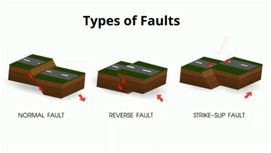
- Fault:
- A fault is a fracture along which the blocks of crust on either side have moved relative to one another parallel to the fracture.
- When an earthquake occurs, the rock on one side of the fault slips with respect to the other.
- The fault surface can be vertical, horizontal, or at some angle to the surface of the earth.
- Tectonic Plates:
- A tectonic plate (also called lithospheric plate) is a massive, irregularly-shaped slab of solid rock, generally composed of both continental and oceanic lithosphere.
- A tectonic plate may be a continental plate or an oceanic plate, depending on which of the two occupies the larger portion of the plate.
- The Pacific plate is largely an oceanic plate whereas the Eurasian plate is a continental plate.
Earthquake
- An earthquake in simple words is the shaking of the earth. It is a natural event. It is caused due to release of energy, which generates waves that travel in all directions.
- The vibrations called seismic waves are generated from earthquakes that travel through the Earth and are recorded on instruments called seismographs.
- The location below the earth’s surface where the earthquake starts is called the hypocenter, and the location directly above it on the surface of the earth is called the epicenter.
- Types of Earthquake: Fault Zones, Tectonic Earthquakes, Volcanic Earthquake, Human Induced Earthquakes.
Seismic Hazard Map of India
- India is one of the highly earthquake affected countries because of the presence of technically active young fold mountains - Himalaya.
- India has been divided into four seismic zones (II, III, IV, and V) based on scientific inputs relating to seismicity, earthquakes occurred in the past and tectonic setup of the region.
- Previously, earthquake zones were divided into five zones with respect to the severity of the earthquakes but the Bureau of Indian Standards (BIS) grouped the country into four seismic zones by unifying the first two zones.
- BIS is the official agency for publishing the seismic hazard maps and codes.
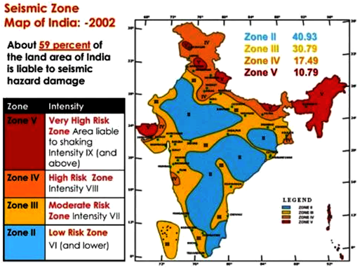
- Seismic Zone II:
- Area with minor damage earthquakes corresponding to intensities V to VI of MM scale (MM-Modified Mercalli Intensity scale).
- Seismic Zone III:
- Moderate damage corresponding to intensity VII of MM scale.
- Seismic Zone IV:
- Major damage corresponding to intensity VII and higher of MM scale.
- Seismic Zone V:
- Area determined by pro seismically of certain major fault systems and is seismically the most active region.
- Earthquake zone V is the most vulnerable to earthquakes, where historically some of the country’s most powerful shocks have occurred.
- Earthquakes with magnitudes in excess of 7.0 have occured in these areas, and have had intensities higher than IX.


