Governance
Geospatial Technologies for the Water Sector in India
- 22 Jul 2021
- 8 min read
Why in News
Recently, the Association of Geospatial Industries released a report titled “Potential of Geospatial Technologies for the Water Sector in India''. The report mentions opportunities in the Water sector that can benefit from the use of Geospatial technologies.
- As the severity of the water crisis in India increases every year, central and state government agencies are using a variety of resources to tackle the water crisis. One among them is the adoption of Geospatial technologies.
Key Points
- Overview of Water Sector in India:
- Demand-Supply Mismatch: India has about 17% of the world population, but only about 4% of the world’s freshwater reserves, and is currently facing a severe water challenge.
- Further, total capacity of India’s reservoirs stands at 250 billion cubic meters (bcm), while its total water bearing capacity over the surface is around 320 bcm.
- Low Rate of Collection: India receives 3,000 billion cubic metres of water every year through rainfall or other sources such as glaciers; of this, only 8% is collected.
- Over-extraction & Over-reliance on Groundwater: India fills groundwater aquifers at the rate of 458 bcm per year, while it extracts around 650 bcm of water from the earth.
- 89% of India’s water resources are used for agriculture, out of which 65% is withdrawn from under the ground.
- Thus, one of India’s biggest challenges is to conserve groundwater.
- Water Stress: As per a NITI Aayog report, currently nearly 820 million people in 12 major river basins of India face extreme water stress.
- Qualitative Issue: Adding to the issue of lack of water availability is the issue of water quality.
- Groundwater in one-third of India’s 600 districts is contaminated mainly through fluoride and arsenic.
- Further, there has been a 136% increase in the number of grossly polluting industries between 2011- 2018, according to the State of India’s Environment report, 2019.
- Demand-Supply Mismatch: India has about 17% of the world population, but only about 4% of the world’s freshwater reserves, and is currently facing a severe water challenge.
- Need to Conserve Water:
- Given the population density and requirement of water for agriculture, India is heavily dependent on groundwater and is one of the worst hit countries as far as the water crisis is concerned.
- Availability of clean water to all for personal, industrial, and agricultural use will not only ensure India reaches its vision of becoming a USD 5 Trillion economy but will also enable it to achieve the United Nations Sustainable Development Goals.
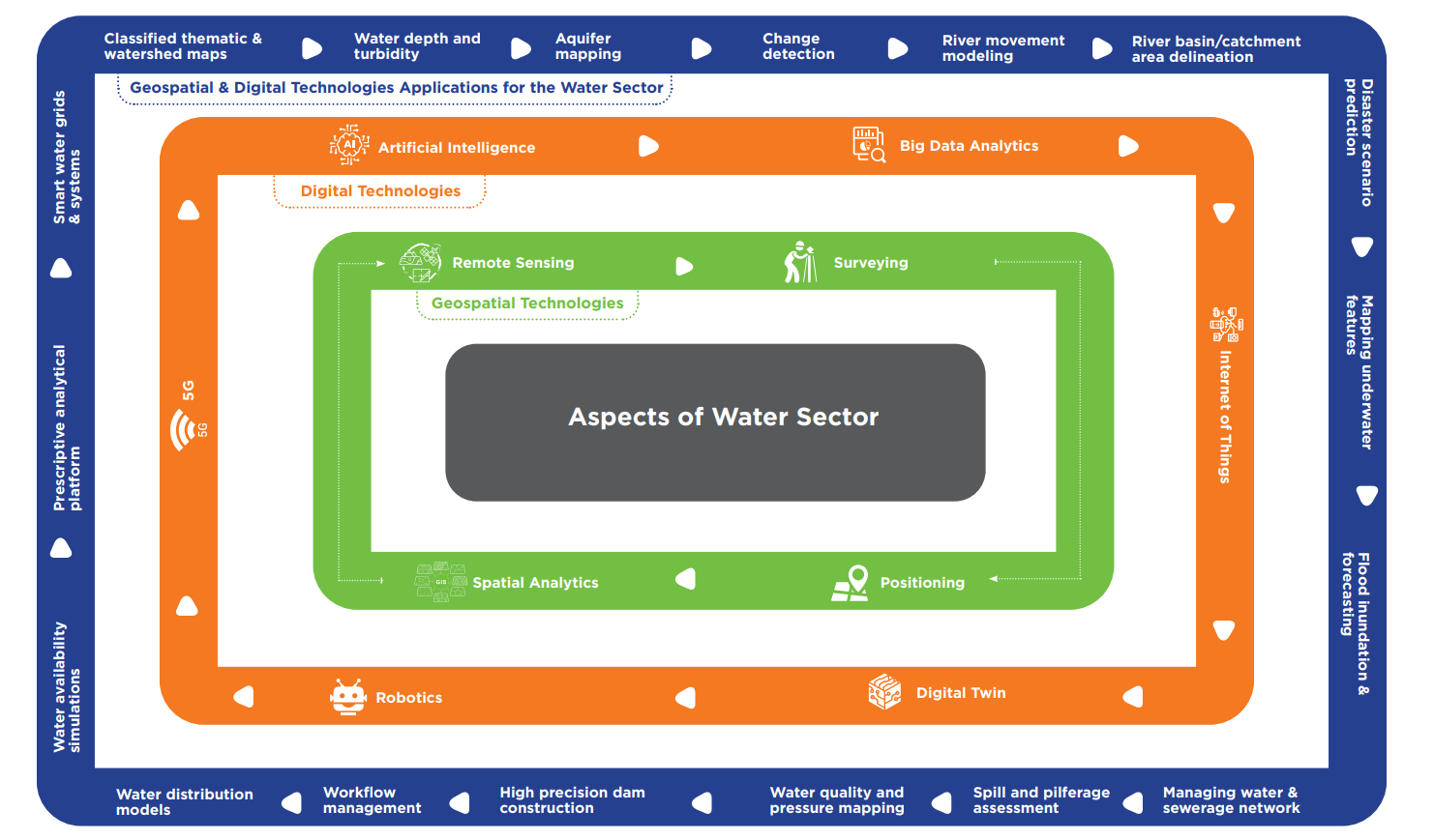
- About Geospatial Technologies:
- Geospatial technologies is a term used to describe the range of modern tools contributing to the geographic mapping and analysis of the Earth and human societies.
- The term 'geospatial' refers not to one single technology, but a collection of technologies that help to collect, analyse, store, manage, distribute, integrate, and present geographic information.
- Broadly speaking, it consists of the following technologies:
- Benefits: Geospatial technology enables better measurement, management, and maintenance of assets, monitoring of resources and even providing predictive and prescriptive analysis for forecasting and planned interventions.
- Geospatial Technology for Water Sector:
- Geospatial and digital technologies like Satellite Based Remote Sensing, GPS Based Equipment and Sensors, Artificial Intelligence, Big Data Analytics, Internet of Things, 5G, Robotics and Digital Twin, can be effectively used to combat the water crisis.
- Major Ongoing Water Projects in India:
- Recognising the water crisis in India, the government of India formed a single ministry i.e Ministry of Jal Shakti. Previously, water was a subject which was dealt with by almost nine Ministries.
- Jal Jeevan Mission
- Dam Rehabilitation and Improvement Project (DRIP)
- Namami Gange
- National River Linking Project (NRLP)
- Atal Mission for Rejuvenation and Urban Transformation (AMRUT)
- National Hydrology Programme
- Pradhan Mantri Krishi Sinchayi Yojana (PMKSY)
- National Aquifer Mapping and Management Programme (NAQUIM)
- River Basin Management
- Atal Bhujal Yojana (ABHY)
- National Water Mission
Digital Twin
- Digital Twin is a virtual replica of the physical world, its dynamics, and processes, which allow us to simulate real life situations and analyse its impact.
- Digital twins are composed of three parts:
- the physical entities in the physical world,
- the virtual models in the virtual world, and
- the connected data that tie the two worlds.
- Digital Twins not only integrate the digital representation of physical assets, like physical systems of pipes, pumps, valves, and tanks, but also include historical data sets such as weather records and realtime dynamic interactions, which allow them to be used for multiple analyses.
Way Forward
- Long-term Geospatial Vision: In order to derive maximum benefit from geospatial technology implementation in various programmes, user departments need to build a long-term vision of the outcomes of geospatial implementation.
- Integrated Geospatial Platform: An integrated collaborative platform to connect the data and technology used by various organizations need to be developed for seamless access to information both locally and nationally and enable decision making.
- Data and System Integration: Various datasets including demography, socio-cultural, economic, and other parameters need to be integrated with spatial and non-spatial data related to water, like soil moisture, annual rainfall, rivers, aquifer, groundwater levels, water quality etc.
- Improving Water Use Efficiency: Agriculture sector is the largest user of water resources in our country.
- They use 80-85% of water resources, while have only about 30-35% efficiency of water use.
- Geospatial technologies can be used for increasing water use efficiency, so that this can be increased to at least 50%.
- Sharing of Best Practices: A lot of good work has taken place in pockets within state governments or within programmes related to the water sector.
- A lot of knowledge exists that can help stakeholders to leverage from and not reinvent the wheel.
- A central repository of such a knowledge base, in the form of a Knowledge Portal can be created and maintained by the Ministry of Jal Shakti that includes case studies, best practices, tools, information on data sources etc.


