Governance
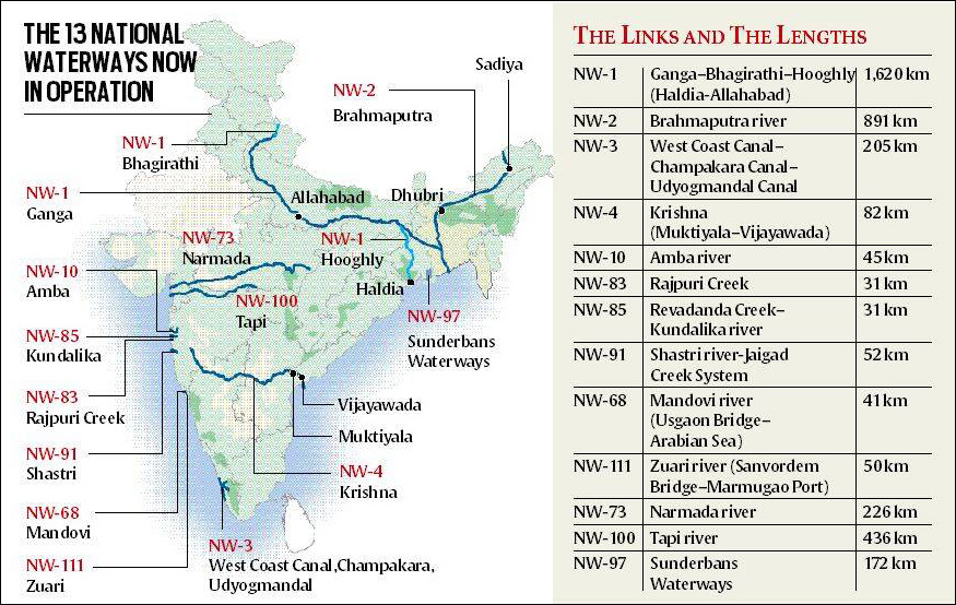
Brahmaputra (NW2) gets connected with Ganga (NW1)
- 08 Mar 2022
- 8 min read
For Prelims: Inland Waterways, Indo-Bangladesh (Sonamura-Daudkandi), Indo-Myanmar protocol (Kaladan).
For Mains: Inland Waterways Network advantages and challenges, Initiatives taken for Inland Waterways
Why in News?
Recently, the Union Minister of Ports, Shipping & Waterways received the maiden voyage of food-grains from Patna to Pandu port via Bangladesh in Guwahati (Assam).
- Inland Waterways Authority of India (IWAI) is planning to run a fixed schedule sailing between NW1 and NW2 heralding a new age of inland water transport for Assam & the Northeast India.
- The Inland Vessels Bill, 2021, was also approved to regulate safety, security and registration of inland vessels.
What is the Significance of this Achievement?
- The start of cargo movement through ships through Indo Bangladesh Protocol Route (IBRP) marks the beginning of a new age of economic prosperity for the whole region of Northeast.
- This will pave the way for growth & development of inland water transport.
- This will also provide the business community a viable, economic & ecological alternative and will also play a pivotal role in energising India’s northeast as the engine of growth.
- The sustained effort to rejuvenate the historical trade routes via Bangladesh got a fillip under PM Gati Shakti.
- It has been envisioned that Northeast will slowly turn & convert into a connectivity hub.
- The integrated development plan, under PM Gati Shakti, has been envisioned in order to amp up swift movement of cargo over Brahmaputra.
What are Inland Waterways?
- About:
- India has about 14,500 km of navigable waterways which consist of rivers, canals, backwaters, creeks, etc.
- As per the National Waterways Act 2016, 111 waterways have been declared as National Waterways (NWs).
- NW-1: Ganga-Bhagirathi-Hooghly River System (Prayagraj-Haldia) with length 1620 km is the longest National Waterway in India.
- The Inland Waterways Authority of India (IWAI) is implementing the Jal Marg Vikas Project (JMVP) for capacity augmentation of navigation on the Haldia-Varanasi stretch of Ganga (part of NW-1) with the technical and financial assistance of the World Bank.
- Related Steps taken:
- The waterways have also been proposed to be linked to the eastern and western Dedicated Freight Corridors (DFCs), as well as the Sagarmala Project, which aims to promote port-led direct and indirect development.
- Further, the provisions of the Indo-Bangladesh (Sonamura-Daudkandi) and Indo-Myanmar protocol (Kaladan) permitting transhipment of goods through Bangladesh and Myanmar waters – which, in many cases, are a continuum of India’s inland waterways – enabling quicker shipments and deeper market penetration in India’s North East.
What is the Scope of Inland Waterways in India?
- About 55 million tonnes of cargo is being moved annually by IWT (Inland Water Transport), a fuel-efficient and environment-friendly mode.
- However, freight transportation by waterways is highly underutilized in the country as compared to developed countries.
- Its operations are currently restricted to a few stretches in the Ganga-Bhagirathi-Hooghly rivers, the Brahmaputra, the Barak river (northeastern India), the rivers in Goa, the backwaters in Kerala, inland waters in Mumbai and the deltaic regions of the Godavari - Krishna rivers.
- Besides these organized operations by mechanized vessels, country boats of various capacities also operate in various rivers and canals and substantial quantum of cargo and passengers are transported in this unorganized sector as well.
- In India, IWT has the potential to supplement the overburdened railways and congested roadways. In addition to cargo movement, the IWT sector also provides a convenient function in related activities such as carriage of vehicles {on Roll-on-Roll-off (Ro-Ro) mode of cross ferry} and tourism.
What are the Advantages of an Inland Waterways Network?
- Cheaper Mode of Transportation:
- Waterways are a cheaper mode of transportation vis-à-vis the available alternatives, significantly reducing the point-to-point cost of goods transportation.
- It also reduces time, cost of transportation of goods and cargos, as well as congestion and accidents on highways.
- The network requires no green field investment, but only capex (capital expenditure) for improvement/upgradation.
- Seamless Interconnectivity:
- They are expected to also “help create seamless interconnectivity connecting hinterlands along navigable river coasts and coastal routes” and “are likely to play a crucial role in connecting the north-eastern states to the mainland.”
What are the Implementation Challenges?
- No Navigability throughout the Year:
- Some rivers are seasonal and do not offer navigability through the year. Around 20 out of the 111 identified national waterways have reportedly been found unviable.
- Intensive Capital and Maintenance Dredging:
- All the identified waterways require intensive capital and maintenance dredging, which could be resisted by the local community on environmental grounds, including displacement fears, thereby posing implementation challenges.
- Other Uses of water:
- Water also has important competing uses, viz. need for living as well as for irrigation, power generation etc. It would not be possible for the local government/others to overlook these needs.
- Exclusive Jurisdiction of the Central Government:
- The exclusive jurisdiction of the Central Government is only in regard to shipping and navigation on inland waterways declared to be ‘national waterways’ by an act of Parliament.
- Utilisation/sailing of vessels, in other waterways, is within the ambit of the concurrent list or is in the jurisdiction of the respective state governments.
Way Forward
- Water being a scarce resource with competing needs, the use of water for transport may be difficult to justify. However, considering the various advantages and taking into account the commercial viability, the numerous opportunities for employment and economic development, the National Waterways can be effectively used as the way forward.
- An effective waterways network would necessitate drawing up a well-coordinated strategy on lines of complementarity between the national network and other waterways, not declared as such, as well as between waterways and roadways/railways.
- The strategy should closely look into the various undercurrents, including competing uses/needs, possible local resistance and also work closely and in coordination with local governments for quick and successful implementation of this important national project.


