Geography
Indonesia Relocating its Capital
- 19 Jan 2022
- 8 min read
For Prelims: Indonesia’s new capital, Rising Sea Levels and responsible factors
For Mains: Reasons of Rising Sea Levels and its consequences, Steps needs to be taken it address this issue, Impact of Climate Change
Why in News
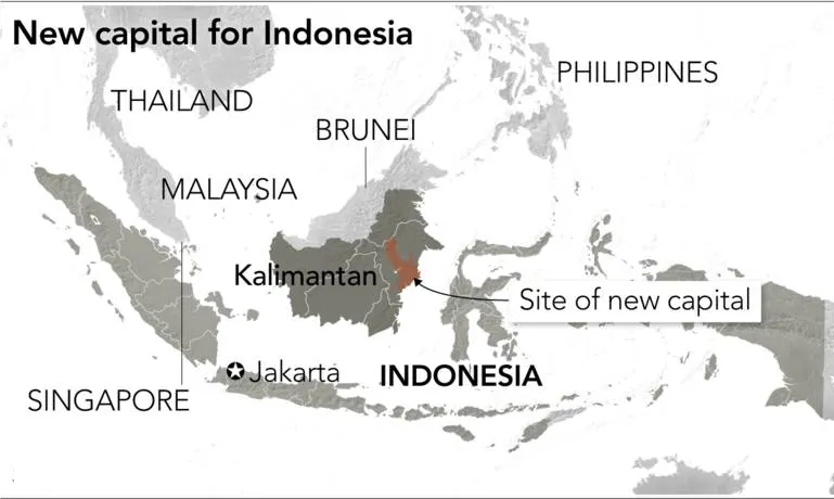
Recently, Indonesia's parliament has passed a law approving the relocation of its capital from slowly sinking Jakarta to a site 2,000 kilometres away on jungle-clad Borneo island that will be named "Nusantara".
- The move was first tipped by President Joko Widodo in April 2019, citing rising sea levels and severe congestion on densely populated Java island.
- Jakarta lies on the northwest coast of Java. The largest islands in Indonesia are Sumatra, Java, Kalimantan (Indonesian Borneo), Sulawesi, and the Indonesian part of New Guinea (known as Papua or Irian Jaya).
Key Points
- Reasons for Relocation:
- Jakarta has long been plagued by serious infrastructure problems and flooding exacerbated by climate change, with experts predicting up to a third of the city could be underwater by 2050.
- Jakarta is home to more than 30 million people in its greater metro area.
- Moreover, Jakarta is the centre for administration, governance, finance and trade, it has inevitably led to relentless construction in the city, due to which the water is not able to seep into the ground in many areas, leading to increased run-off.
- Jakarta has been Indonesia’s capital since the country became independent in 1949. The city has become overcrowded and extremely polluted for the last few decades.
- Another important reason to shift the capital from Java island to Borneo island has been the growing inequality – financial and otherwise.
- Java Island, especially Jakarta which is spread across more than 661.5 square kilometres, is immensely populated whereas East Kalimantan, spread across 127,346.92 square kilometres, is bigger than Jakarta, it is a lot less populated than the current capital.
- Jakarta has long been plagued by serious infrastructure problems and flooding exacerbated by climate change, with experts predicting up to a third of the city could be underwater by 2050.
- Relocation Site:
- The new capital (Nusantara) will cover about 56,180 hectares in East Kalimantan province on the Indonesian part of Borneo, which the country shares with Malaysia and Brunei.
- However, environmentalist critics of the capital's move have warned it could damage ecosystems in the region, where mining and palm oil plantations already threaten rainforests that are home to Borneo's endangered species.
Note
- Indonesia is not the first country in the region to relocate from an overpopulated capital.
- Malaysia moved its government to Putrajaya from Kuala Lumpur in 2003, while Myanmar moved its capital to Naypyidaw from Rangoon in 2006.
Sea Level Rise (SLR)
- About: SLR is an increase in the level of the world’s oceans due to the effects of climate change, especially global warming, induced by three primary factors:
- Thermal Expansion: When water heats up, it expands. About half of the sea-level rise over the past 25 years is attributable to warmer oceans simply occupying more space.
- Melting Glaciers: Higher temperatures caused by global warming have led to greater-than-average summer melting of large ice formations like mountain glaciers as well as diminished snowfall due to later winters and earlier springs.
- That creates an imbalance between runoff and ocean evaporation, causing sea levels to rise.
- Loss of Greenland and Antarctic Ice Sheets: As with mountain glaciers, increased heat is causing the massive ice sheets that cover Greenland and Antarctica to melt more quickly, and also move more quickly into the sea.
- Rate of SLR:
- Sea level is primarily measured using tide stations and satellite laser altimeters.
- According to the Intergovernmental Panel on Climate Change (IPCC), 2021 report, sea-level rise has tripled compared with 1901-1971. The Arctic Sea ice is the lowest it has been in 1,000 years.
- Consequences of SLR:
- Coastal Flooding: Globally, eight of the world's 10 largest cities are near a coast, which is threatened by coastal flooding.
- Destruction of Coastal Biodiversity: SLR can cause destructive erosion, wetland flooding, aquifer and agricultural soil contamination with salt, and lost habitat for biodiversity.
- Dangerous Storm Surges: Higher sea levels are coinciding with more dangerous hurricanes and typhoons leading to loss of life and property.
- Lateral and Inland Migration: Flooding in low-lying coastal areas is forcing people to migrate to the higher ground causing displacement and dispossession and in turn a refugee crisis worldwide.
- Impact on Infrastructure: The prospect of higher coastal water levels threatens basic services such as internet access.
- Threat to Inland Life: Rising seas can contaminate soil and groundwater with salt threatening life farther away from coasts.
- Tourism and Military Preparedness: Tourism to coastal areas and military preparedness will also be negatively affected by an increase in SLR.
- Steps taken to Tackle SLR:
- Relocation: Many coastal cities have planned to adopt relocation as a mitigation strategy. For example, Kiribati Island has planned to shift to Fiji, while the Capital of Indonesia is being relocated from Jakarta to Borneo.
- Building Sea Wall: Indonesia’s government launched a coastal development project called a Giant Sea Wall or "Giant Garuda" in 2014 meant to protect the city from floods.
- Building Enclosures: Researchers have proposed Northern European Enclosure Dam (NEED), enclosing all of the North Sea to protect 15 Northern European countries from rising seas. The Persian Gulf, the Mediterranean Sea, the Baltic Sea, the Irish Sea, and the Red Sea were also identified as areas that could benefit from similar mega enclosures.
- Architecture to Steer Flow of Water: Dutch City Rotterdam built barriers, drainage, and innovative architectural features such as a "water square" with temporary ponds.
- India’s Case:
- Vulnerability:
- India's 7,516-kilometre-long coastline includes 5,422 kilometres of coastline on the mainland and 2,094 kilometres on the islands belonging to nine states and four Union Territories.
- The coastline accounts for 90% of the country's trade and it spans 3,331 coastal villages and 1,382 islands.
- Related Initiatives:
- Vulnerability:


