Governance
India State of Forest Report (ISFR) 2021
- 27 Jan 2022
- 30 min read
About:
- It is the 17th biennial assessment of India’s forests by the Forest Survey of India, an organisation under the Ministry of Environment, Forest and Climate Change (MoEFCC).
- The ISFR 2021 presents the latest status of the 'Forest cover' and 'Tree cover' of the country, estimates of growing stock, the extent of trees outside forests, mangrove cover, bamboo resources, and assessment of forest carbon stock.
- In addition to the regular chapters, this time round, a special chapter on “Forest Cover assessment in Tiger reserves and Tiger corridor areas of the country and decadal change in Forest Cover” has also been included.
- Results of the two special studies namely Above Ground Biomass Estimation using Synthetic Aperture Radar data (carried out in collaboration with ISRO) and Climate hot spots in forest areas studies (carried out in collaboration with BITS Pilani, Goa campus) are also being presented in this report.
- New initiatives taken up in the last two years by the Forest Survey of India (FSI) team are also being presented as a special chapter.
- India's progress towards achieving the Nationally Determined Contribution commitments are also included as part of the chapter on Forest carbon assessment.
Key Findings
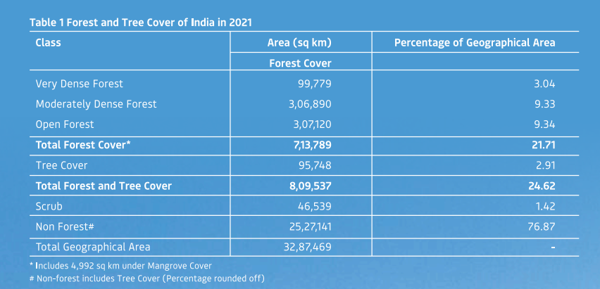
- The Total Forest and Tree cover is 24.62% of the geographical area of the country.
- The Total Forest cover is 7,13,789 sq km which is 21.71% of the geographical area of the country.
- The Tree cover is 2.91% of the geographical area of the country.
- As compared to ISFR 2019 the current assessment shows an increase of:
- 0.28% of forest and tree cover put together, at the national level.
- Forest Cover: 0.22%
- Tree Cover: 0.76%
- Change in Recorded forest Area/Green Wash (RFA/GW) as compared to previous assessment of 2019.
- Forest Cover within the RFA/GW: A slight increase of 31 sq km.
- Forest Cover outside the RFA/GW: There is an increase of 1,509 sq km.
- The top five states in terms of increase in forest cover:
- Andhra Pradesh>Telangana>Odisha>Karnataka>Jharkhand.
- Forest cover in the hill districts is 40.17% of the total geographical area of these districts. A decrease of 902 sq km (0.32%) in 140 hill districts of the country.
- The total forest cover in the tribal districts is 37.53% of the geographical area of these districts.
- The current assessment shows a decrease of 655 sq km of forest cover inside the RFA/GW in the tribal districts and an increase of 600 sq km outside.
- Total forest cover in the North-Eastern region is 64.66% of its geographical area. The current assessment shows a decrease of forest cover to the extent of 1,020 sq km (0.60%) in the region.
- Mangrove cover: The Mangrove cover in the country has increased by 0.34% as compared to the previous assessment.
- Total Carbon Stock: The total carbon stock in forests is estimated as 7,204.0 million tonnes an increase of 79.4 million tonnes since 2019.
- Forest Prone to Fire: The analysis reveals that 22.27% of the forest cover is prone to forest fire.
- Bamboo Forests: The total bamboo bearing area of the country is estimated as 1,49,443 sq km. There is a decrease of 10,594 sq km in the bamboo bearing area as compared to the estimate of ISFR 2019.
Chapter 1- Introduction
- Forest Cover: The forest canopy area is covered on the ground irrespective of the legal status of the land. It includes all tree patches which have a canopy density of more than 10% and an area of 1 ha or more in size.
- Canopy Density: It is defined as the proportion of an area in the field/ground that is covered by the crown of trees.
- Recorded Forest Area (RFA):
- Forest Area (or recorded forest area) refers to all the geographic areas recorded as forest in government records.
- Recorded forest areas comprise Reserved Forests (RF) and Protected Forests (PF), which have been constituted under the provisions of the Indian Forest Act, 1927.
- Besides RFs and PFs, the recorded forest area may include all such areas, which have been recorded as forests under any State Act or local laws or any revenue records.
- TOF (Trees Outside Forest): Trees found outside the recorded forest areas. TOF refers to all trees growing outside RFA irrespective of patch size which could also be larger than 1 ha.
- Tree cover: All patches of trees occurring outside RFA which are of size less than 1 ha including the scattered trees. Tree cover forms an important part of the trees outside forests (TOF). Therefore, tree cover can be considered as a subset of TOF.
- Forest & Tree Cover: 'Forest cover' and 'tree cover' put together constitutes 'Forest & Tree Cover' which is the key parameter for monitoring progress as per the National Forest Policy' goal of achieving 33% of the country's geographical area under green cover.
.png)
Chapter 2- Forest Cover
- National Forest Policy of India, 1988 envisages a goal of achieving 33% of the geographical area of the country under forest and tree cover.
- The main objectives:
- To monitor forest cover and changes therein at the National, State, and District levels.
- To generate information on forest cover in different density classes and changes therein.
- To produce forest cover and other thematic maps derived from it for the whole country.
- To provide a primary base layer for assessment of different parameters including growing stock, forest carbon, etc.
- To provide information for international reporting.
- Forest cover: Includes all lands having trees of more than one hectare in an area with a tree canopy density of more than 10%, irrespective of ownership, the legal status of the land, and species composition of trees.
- Very Dense Forest: All lands with tree canopy density of 70% and above. The relative composition of forest cover under this category is 3.04%
- Moderately Dense Forest: All lands with tree canopy density of 40% and more but less than 70%. Forest cover under this category is 9.33%
- Open Forest: All lands with tree canopy density of 10% and more but less than 40 %. The forest cover of 9.34% falls under this category.
- Scrub Forest: Lands with canopy density less than 10%. The geographical area under this category is 1.42%.
- Non-forest: Lands not included in any of the above classes (includes water). The geographical area under the non-forest category is 76.87%.
.png)
- Largest forest cover in India: Madhya Pradesh > Arunachal Pradesh > Chhattisgarh > Odisha > Maharashtra
- The states from the North eastern region of the country have the highest percentage of forest cover w.r.t. total geographical area of the state.
- Mizoram (84.53%) > Arunachal Pradesh (79.33%) > Meghalaya (76.00%) > Manipur (74.34%) > Nagaland (73.90%).
- There has been a net increase of 1,540 sq km in the Forest Cover at the national level.
- States showing a significant gain in forest cover: Andhra Pradesh > Telangana > Odisha > Karnataka > Jharkhand.
- States showing loss in forest cover: Arunachal Pradesh > Manipur > Nagaland > Mizoram > Meghalaya.
- As per the report, there is a decrease of 902 sq km of Forest Cover in the hill districts of the country.
- There is an overall decrease in Forest Cover in the tribal districts by 55 sq km, however, the Forest Cover inside the Recorded Forest Areas/Green wash areas in the tribal districts shows a decrease of 655 sq km.
- There are 218 tribal districts in 27 States/UTs as identified by the Government of India under the Integrated Tribal Development Programme.
- There is an overall decrease of 1,020 sq. km of Forest Cover in the North Eastern States.
- Forest Cover of Seven Major Cities has been carried out. The total Forest Cover in the seven major cities is 509.72 sq km which is 10.21% of the total geographical area of the cities.
- There has been an increase of 68 sq km of Forest Cover in the last ten years.
- Maximum gain in Forest Cover is seen in Hyderabad followed by Delhi while Ahmedabad and Bengaluru have lost Forest Cover.
.png)
Chapter 3- Mangrove Cover
- Mangroves: These are a diverse group of salt-tolerant plant communities of tropical and subtropical intertidal regions of the world.
- Mangrove species exhibit a variety of adaptations in morphology, anatomy, and physiology to survive in waterlogged soils, high salinity, and frequent cyclonic storms and tidal surges.
- Mangroves are important refuges of coastal biodiversity and also act as bio-shields against extreme climatic events.
- Importance of Mangroves:
- Mangroves have a complex root system that is very efficient in dissipating the sea wave energy thus protecting the coastal areas from tsunamis, storm surges, and soil erosion. Their protective role has been widely recognized especially after the devastating Tsunami of 2004.
- Mangrove roots slow down water flows and enhance sediment deposition. Therefore, they act as a zone of land accretion due to the trapping of fine sediments including heavy metal contaminants. They also arrest coastal erosion and sea water pollution.
- They act as a fertile breeding ground for many fish species and other marine fauna.
- They act as an important source of livelihood for the coastal communities dependent on the collection of honey, tannins, wax, and fishing.
- Mangroves are important carbon sinks.
- Reasons behind the damaging of Mangroves:
- Biotic pressure and natural calamities play a major role in negatively impacting Mangrove ecosystems.
- Growing land reclamation for agriculture and industrialization along the coastlines and discharge of untreated domestic sewage and industrial effluents are damaging to these forests.
- Upstream activities related to river training and natural erosion and accretion also have an effect on the health of Mangroves since an adequate ecological flow in the rivers is essential for flushing the Mangroves of silt and other wastes.
- Conservation of Mangroves: According to Champion & Seth Classification (1968), Mangroves are included in Type Group- 4 Littoral & Swamp Forests.
- Important species of Mangrove ecosystems in India include:
- Avicennia officinalis, Rhizophora mucronata, Sonneratia alba, Avicennia alba, Bruguiera cylindrica, Heritiera littoralis, Phoenix paludosa, Morinda citrifolia & Ceriops tagal.
- Sunderban, located in the northern Bay of Bengal is the world's largest single patch of Mangrove Forests. Spread over approximately 10,000 sq km, in Bangladesh and India.
- Sundarban is the first Mangrove forest in the world, which was brought under scientific management, as early as in 1892.
- Appreciating the importance of Mangroves, the Government of India set up a National Mangroves Committee in 1976 to advise the Government on issues related to the conservation and development of Mangroves in the country.
- Important species of Mangrove ecosystems in India include:
- Status of Mangrove Cover Worldwide: As per Global Forest Resource Assessment, 2020 (FRA 2020), the world over, 113 countries have Mangrove forests covering an estimated 14.79 million hectares.
- The largest Mangrove area is reported in:
- Asia > Africa > North and Central America > South America.
- Oceania has reported the smallest area of Mangroves.
- More than 40% of the total area of Mangroves was reported to be in just four countries: Indonesia (19%), Brazil (9%), Nigeria (7%), and Mexico (6%).
- The largest Mangrove area is reported in:
- Status of Mangrove Cover in India: The mangrove cover in India is 4,992 sq km, which is 0.15% of the country’s total geographical area.
- Increase in the mangrove cover as compared to 2019 assessment: 17 sq km
- The states that show significant gain in Mangrove cover are Odisha and Maharashtra.
.png)
Chapter 4- Assessment of Forest Cover in Tiger Reserves and Lion Conservation Area of India
- The Royal Bengal Tiger (Panthera tigris):
- Considered as an umbrella species whose conservation indirectly protects many other species at the ecosystem and landscape level.
- It is an "Endangered species” on the International Union for Conservation of Nature (IUCN) Red List.
- The Asiatic Lion (Panthera leo persica): The Lion was widely spread over India earlier but now its natural habitat is restricted only to the Gir area of Gujarat.
- It is listed as "Endangered species:” on the IUCN Red List because of its small population size and area of occupancy.
- India’s Contribution:
- The Tigers in India account for 70% of the world's total Tiger population (3,890) followed by Russia and Indonesia'.
- World Wildlife Fund (WWF): India is a party to the TX2 agreement of the WWF which is a global commitment to double the world's wild Tigers by 2022, in thirteen Tiger range countries (i.e. India, Nepal, Bhutan, Bangladesh, Myanmar, Russia, China, Malaysia, Thailand, Cambodia, Lao PDR, Vietnam, and Indonesia).
- Tiger Task Force: This force was set up by the Indian Board for Wildlife (IBWL) to suggest conservation measures for saving the Tiger from extinction.
- On the recommendation of this task force, the 'Project Tiger', was launched on April 1, 1973, to restore Tiger habitats and ensure the maintenance of a viable population of Tigers.
- Tiger Reserves: The Wildlife Protection Act, 1972 (2006 amendment) provides for the declaration of an area as a Tiger Reserve for the in-situ conservation of Tigers.
- A Tiger reserve is an area, which is kept as inviolate for Tiger conservation and the peripheral area constitutes the buffer, which is a multiple-use area, with a preference to conservation over other land uses, maintaining an equilibrium between wildlife and human activities for livelihood, developmental, social and cultural rights of the local people.
- In terms of forest cover as a percentage of the area of Tiger reserves, the top five Tiger reserves are:
- Pakke in Arunachal Pradesh (96.83%) > Achanakmar in Madhya Pradesh (95.63%) > Simlipal in Odisha (94.17%) > Kali in Karnataka (92.45%) > Dampa in Mizoram (92.05%).
.png)
- Decadal Change in Forest Cover (IFSR 2011- IFSR 2021):
- Between 2011 and 2021, the forest cover has decreased by 22.62 sq km (0.04%).
- The Tiger reserves showing a significant gain in forest cover are:
- Buxa > Anamalai > Indravati
- The maximum losses in forest cover are recorded from:
- Kawal > Bhadra > Sundarbans
- Wetlands: The 5,821 wetlands cover 7.20% of the total area of the Tiger reserves.
- The Sundarban Tiger Reserve has the largest area under wetlands accounting for 96.76% of its total area.
- Kanha Tiger Reserve has the highest number of wetlands, 461 wetlands.
Chapter5- Forest Fire & Monitoring
- MoEF&CC has come up with the National Action Plan on Forest Fires, 2018 to revamp forest fire management in the country.
- Main objectives:
- Informing
- Enabling and
- Empowering forest fringe communities
- Incentivizing them to work in tandem with the State Forest Departments (SFDs)
- This plan also aims at substantially reducing the vulnerabilities of forests across the diverse forest ecosystems in the Indian subcontinent against fire hazards, enhancing the capabilities of forest and other personnel and institutions in fighting fires, use of technology, and speeding up recovery after a fire event.
- As per the long-term trend analysis performed by FSI, nearly 10.66% area of Forest Cover in India is under extremely to very highly fire prone zone.
- States under North-Eastern Region showed the highest tendency of forest fire, and these states fall under extremely to very highly forest fire zone.
- States like Mizoram, Tripura, Meghalaya, and Manipur in the North-Eastern Part of India exhibit the highest forest fire probability in terms of its frequency of event occurrence.
- Parts of Western Maharashtra, the Southern part of Chhattisgarh, the Central part of Odisha, and a few parts of Andhra Pradesh, Telangana, and Karnataka are showing patches of extremely and very highly fire-prone zones.
.png)
Chapter 6- Tree Cover
- The total tree cover of the country has been estimated to be 95,748 sq km.
- There is an increase of 721 sq km in the extent of tree cover as compared to the 2019 assessment.
- State-wise estimates of Tree Cover:
- Maximum Tree Cover: Maharashtra > Rajasthan >Madhya Pradesh > Karnataka > Uttar Pradesh
- Maximum Tree Cover as percentage of geographical area: Chandigarh > Delhi > Kerala > Goa
- State-wise estimates of Tree Outside Forest (TOF)
- Maximum extent of TOF: Maharashtra > Odisha > Karnataka
- Maximum extent of TOF as a percentage of geographical area: Lakshadweep > Kerala > Goa
- Over the last 5 biennial assessments, the tree cover of the country has shown an increasing trend.
- The tree cover has risen from 90,844 sq km in the 2011 assessment to 95,748 sq km as per the 2021 assessment, showing a decadal increase of 4,904 sq km.
Chapter 7- Growing Stock
- National Forest Inventory (NFI):
- It is a major forest resource assessment activity carried out by FSI.
- The primary objective is to assess the growing stock of trees, the number of trees, bamboo, soil carbon, the occurrence of NTFP (Non-Timber Forest Products) and invasive species, and other parameters depicting the growth & health of the forest.
- The NFI has three components: Forest Inventory, TOF (Rural) Inventory, and TOF (Urban) Inventory.
- Over the last 3 biennial assessments, the growing stock within and outside forests has shown a steady increasing trend.
- The total growing stock has risen by 6.92% 2021 assessment.
- The growing stock inside forests has risen by 4.60% in the current assessment.
- In the TOF, the growing stock has risen by 13.09%.
Chapter 8- Bamboo Resources of the Country
- In India, bamboo grows naturally throughout the country except in the Kashmir region. India is home to about 125 indigenous and 11 exotic species of bamboo from 23 genera.
- Bamboo contributes significantly to the social, economic & ecological development of any region.
- The Bamboo Bearing Area of the Country: 15.00 million hectares.
- As compared to the ISFR 2019, the total bamboo bearing area in the country has decreased by 1.06 million ha.
- States with Maximum Bamboo Bearing Area: Mizoram > Arunachal Pradesh
- States with Minimum Bamboo Bearing Area: Madhya Pradesh> Maharashtra
- Maximum Occurrence of Pure Bamboo: Madhya Pradesh > Maharashtra > Chhattisgarh.
- Top 10 states in terms of bamboo bearing area (%):
.png)
Chapter 9- Carbon Stock in India’s Forest
- The carbon stock for 2021 has been estimated at 7,204.0 million tonnes.
- There is an increase of 79,4 million tonnes of carbon stock as compared to the estimates of the 2019 report.
- State-wise Maximum carbon stock: Arunachal Pradesh > Madhya Pradesh > Chhattisgarh > Maharashtra
- State-wise Maximum per hectare carbon stock: Jammu & Kashmir > Himachal Pradesh > Sikkim > Andaman & Nicobar Island
- Soil organic carbon is the largest pool of forest carbon followed by Above Ground Biomass (AGB), Below Ground Biomass (BGB), Litter, and dead wood.
- As compared to the 2019 assessment, maximum changes have been observed in AGB and dead wood.
Chapter 10- Above Biomass Estimation using SAR Data
- Biomass: Forests perform a variety of ecosystem services, one of the most vital ones being absorbing Carbon dioxide from the atmosphere and converting it into biomass. Biomass refers to the mass of the living organism within a tree.
- Above Ground Biomass (AGB): It contains the part of vegetation above the ground e.g. stumps, trees, deadwood, litter, and foliage.
- Below Ground Biomass (BGB): It includes the parts of the tree (roots) which are situated under the ground.
.png)
- Forest biomass comprises nearly 80% of the total biomass on the earth (Reichstein & Carvalhais, 2019).
- In 2018 FSI, in collaboration with Space Application Centre (SAC), ISRO, Ahmedabad initiated a special study for estimation of Above Ground Biomass (AGB) at pan India level using L- band of Synthetic Aperture Radar (SAR) data.
Chapter-11 Mapping of Climate Change Hotspots in Indian Forests
- A climate hotspot refers to an area, which is prone to adverse climatic change.
- Intergovernmental Panel on Climate Change (IPCC) reports have been continuously highlighting the impacts of climate change.
BITS Pilani Study
- FSI in tune with its mandate of monitoring and assessment of forests of the country has undertaken a collaborative study with BITS Pilani (Goa Campus) to map climate hotspots in the forest areas of the country.
- Aim of the Study: This study is based on the computer model projections of temperature and rainfall in three-time horizons i.e. 2030, 2050, and 2085.
- The enhanced understanding of the climate change hotspot areas in Indian forests would assist in planning and strategizing preventive and adaptive measures against changing climate.
- Outcomes: By analysing all the scenarios in the studied periods i.e. 2030, 2050, and 2085; it has been observed that:
- Highest Temperature Increase: Ladakh, Jammu-Kashmir, Himachal Pradesh, and Uttarakhand.
- Least Temperature Rise: Andaman & Nicobar Islands, West Bengal, Goa, Tamil Nadu, and Andhra Pradesh.
- Highest Increase in Rainfall: The North-Eastern States and Upper Malabar Coast of India
- Least Increase/ Decline in Rainfall: Part of North-Eastern States like Arunachal Pradesh, Sikkim; North-Western parts of the country namely Ladakh, Jammu & Kashmir, and Himachal Pradesh
- Aim of the Study: This study is based on the computer model projections of temperature and rainfall in three-time horizons i.e. 2030, 2050, and 2085.
Chapter 12 - New Initiatives
FSI strived to keep pace with technological advancements to meet the information needs of the forestry sector. New technology and advanced methodology have led to more accurate findings. Some of the new initiatives are given below:
- Trees Outside Forest Resources in India
- A new methodology has been developed to estimate the TOF resources and the extent of the TOF area in the country. Moreover, the potential annual yield from timber from TOF has also been assessed.
- India's Nationally Determined Contribution of creating an additional carbon sink of 2.5 to 3 billion tonnes of CO, eq through additional forest & tree cover: Possibilities, scale, and costs for formulating strategy.
- Variability in forests and optimum sample size for estimation of Growing Stock in different districts of the country: a ready reckoner for Working Plan preparation or any other forest resource assessment exercise
- This study provides an optimum sample size for different districts of the country for conducting inventories to estimate the growing stock. This will be of immense use to the State Forest Department, especially in the preparation of the Working Plan.
- A new grid-based algorithm for detecting locations of changes in forest vegetation in a pin pointed manner over large landscapes.
- A new index called Grid Vegetation Change Index (GVCI) has been used to detect changes in the forests through a rapid, grid-based approach for operational use. GVCI helps in detecting a change in vegetation over an area of interest between the two time periods.
- Rapid assessment of fire-affected forest areas in the country based on MODIS-detections following a sampling approach
- Since 2004, FSI has been monitoring forest fires using remote sensing techniques and has been issuing forest fire alerts to State Forest Departments.
- Assessment of the fire-affected areas provides an estimate while planning for eco-restoration activities by the states.
- Since fire burnt forest areas show the conspicuous signature on the satellite images, a cost-effective and time-efficient methodology has been developed for the rapid assessment of forest areas affected by the fire.


