Governance
The Case for Open, Verifiable Forest Cover Data
- 02 Mar 2023
- 9 min read
For Prelims: Tree Cover, Forest Cover, India State of Forest Report-2021, Forest Survey of India, Forest (Conservation) rules,2022
For Mains: India State of Forest Report-2021, Issues Associated with Forests in India, Government Initiatives for Forest Conservation.
Why in News?
India ranked third globally in average net forest gain during 2010-2020, but questions are being raised on reliability of its forest data by independent experts, and United Nations Framework Convention on Climate Change (UNFCCC), for mixing plantations with natural forests.
- India's forest cover has increased from 19.53% in the 1980s to 21.71% in 2021, and its total green cover, including tree cover, now stands at 24.62%.
How is Green Cover Calculated?
- About:
- Forest Survey of India (FSI) in its biennial India State of Forest Report (ISFR) presents the latest status of the ‘Forest cover’ and ‘Tree cover' of the country.
- FSI is an organisation under the Ministry of Environment, Forest and Climate Change (MoEFCC).
- India counts all plots of 1 hectare or above, with at least 10% tree canopy density irrespective of land use or ownership, within forest cover.
- This disregards the United Nation’s benchmark that does not include areas predominantly under agricultural and urban land use in forests.
- Forest Survey of India (FSI) in its biennial India State of Forest Report (ISFR) presents the latest status of the ‘Forest cover’ and ‘Tree cover' of the country.
- Classification:
- Very Dense Forest: Land with 70% or more canopy density.
- Dense Forests: All land areas with tree canopy density of 40% and above
- Open Forests: All land areas with tree canopy density between 10-40%
- Tree Cover: Isolated or small patches of trees less than 1 hectare and not counted as forest are counted as tree cover by putting together the crowns of individual patches and trees.

- Global Standard:
- The global standard for “forest” is provided by the Food and Agriculture Organisation (FAO) of the United Nations: at least 1 hectare of land with a minimum of 10% per cent tree canopy cover.
- It does not include areas “predominantly under agriculture or urban land use” in a forest.
What is the Status of India’s Forests?
- National Remote Sensing Agency (NRSA) vs FSI:
- The NRSA used satellite imagery to estimate India's forest cover in 1971-1975 and 1980-1982 and found a loss of 2.79% in just seven years, from 16.89% to 14.10%.
- Government records show that 42,380 sq km of forest land was diverted for non-forest use between 1951 and 1980, although reliable data on encroachment is unavailable.
- The government was initially reluctant to accept the NRSA's findings, but after negotiations, the NRSA and the newly established FSI "reconciled" India's forest cover at 19.53% in 1987.
- Old Forests Lost:
- Recorded Forest Areas, divided into Reserved, Protected and Unclassed forests, accounted for 23.58% of India.
- These are areas recorded as forest in revenue records or proclaimed as forest under a forest law.
- In 2011, FSI reported that nearly one-third (over 2.44 lakh sq km ,larger than Uttar Pradesh or 7.43% of India ) of Recorded Forest Areas had no forest at all and were lost due to encroachment, diversion, forest fire etc.
- Recorded Forest Areas, divided into Reserved, Protected and Unclassed forests, accounted for 23.58% of India.
- Natural Forests Shrink:
- Dense forests within Recorded Forest Areas reduced from 10.88% in 1987 to 9.96% in 2021, a one-tenth slide.
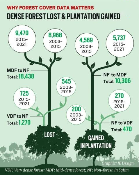
- According to Global Forest Watch, India lost 1,270 sq km of natural forest between 2010 and 2021.
- However, the FSI reported a gain of 2,462 sq km in dense forest and 21,762 sq km in overall forest cover for the same period.
What are the Issues With current Forest cover Data?
- Inclusion of Plantations in Forest Data:
- Loss of natural forests remains invisible due to inclusion of plantations, orchards, urban housings as dense forests.
- The SFR 2021, for example, reports 12.37% dense forest by including random green patches.
- Plantation forests have trees of the same age, are more susceptible to fire, pests and epidemics, and often act as a barrier to natural forest regeneration.
- Natural forests are old and therefore stock a lot more carbon in their body and in the soil and support more biodiversity.
- Plantations can grow a lot more and faster than old natural forests which means plantations can achieve additional carbon targets faster.
- But compared to natural forests, plantations are often harvested more readily, defeating carbon goals in the long term.
- But compared to natural forests, plantations are often harvested more readily, defeating carbon goals in the long term.
- Loss of natural forests remains invisible due to inclusion of plantations, orchards, urban housings as dense forests.
- Lack of Open and Participatory Data:
- FSI never made its data freely available for public scrutiny. Inexplicably, it also bars the media from accessing its geo-referenced maps.
- In 2021, it claimed to have established an overall accuracy of 95.79% in identifying forests from non-forests. However, given the limited resources, the exercise was limited to less than 6,000 sample points.
- Diversion of Forest land:
- Since the Forest Conservation Act was enacted in 1980, at least 10,000 sq km of forests have been lost to diversion for development projects.
- Recent, Forest (Conservation) rules,2022 seek to limit the scope of application of the Act, exempt certain activities from requiring permission for clearing forests and allow raising and harvesting private plantations on forest land etc.
- On paper, the carbon stock keeps growing – annually by 145.6 million tonnes of carbon dioxide equivalent since 2019 – even as the country diverted over 700 sq km of forest land during 2017-2021.
- FSI projected that India will comfortably surpass its carbon commitment to create an additional carbon sink of 2.5 to 3 billion tonnes of carbon dioxide equivalent through additional forest and tree cover by 2030 without implementing additional measures per se for increasing forest carbon sink.
- Inclusion of Residential and Urban Areas:
- According to a few independent Investigations, the bungalows of ministers and senior officers, even the Reserve Bank of India (RBI) building on Sansad Marg, Parts of the campuses of the Indian Institute of Technology (IIT) and All India Institute of Medical Sciences (AIIMS), and residential neighborhoods across Delhi are “forest” in the official forest cover map.
Way Forward
- Data transparency: It is important that maps are made available in public domain for scrutiny. We can take a clue from Brazil, which makes their forest data available on open web.
- Comprehensive Assessment: As the forest survey report is published biennially, it may be carried hurriedly. Thus, this report should be complemented with a comprehensive assessment every 5 years.
UPSC Civil Services Examination Previous Year Question (PYQ)
Q. Examine the status of forest resources of India and its resultant impact on climate change. (2020)
Q. “Policy contradictions among various competing sectors and stakeholders have resulted in inadequate ‘protection and prevention of degradation’ to environment.” Comment with relevant illustrations. (2018)


