Important Facts For Prelims
River Delta Subsidence
- 29 Jan 2026
- 10 min read
Why in News?
A new global study published in Nature warns that several of India’s major river deltas are sinking at alarming rates placing millions at increasing risk of flooding and displacement.
What are Key Findings of the Study?
- About the Study: The research analysed 40 major river deltas across 29 countries, covering areas with over 236 million inhabitants exposed to near-term flood risk.
- In India, the study identifies Ganga-Brahmaputra, Brahmani, Mahanadi, Godavari, Cauvery and Kabani deltas as experiencing significant land subsidence.
- Subsidence Outpacing Sea-Level Rise: Land subsidence exceeds the global mean sea-level rise (~4 mm/year), with over half of deltas subsiding faster than 3 mm/year during 2014–2023. 35% of total delta area globally is sinking, and in 38 of 40 deltas, more than half the area shows subsidence.
- India Related Findings: Brahmani (77%) and Mahanadi (69%) are among the fastest-sinking deltas, with large areas subsiding at over 5 mm per year.
- Nearly 50% of deltas, including the Ganga-Brahmaputra, Brahmani, and Mahanadi, are subsiding across over 90% of their area.
- India Related Findings: Brahmani (77%) and Mahanadi (69%) are among the fastest-sinking deltas, with large areas subsiding at over 5 mm per year.
- Hotspots of Delta Land Loss: 7 major deltas, Ganga-Brahmaputra, Nile, Mekong, Yangtze, Amazon, Irrawaddy and Mississippi, account for 57% of global subsiding delta area (~265,000 sq km).
- Major delta cities such as Kolkata, Alexandria, Bangkok, Dhaka, and Shanghai are sinking at rates equal to or higher than surrounding regions, increasing risks of urban flooding.
- Reasons of Subsidence: Unsustainable groundwater extraction is the primary cause of subsidence in deltas like Ganga-Brahmaputra and Cauvery, leading to irreversible sediment compaction.
- Other deltas, such as the Mahanadi and Kabani, face compounded pressures from groundwater depletion, reduced sediment supply due to river regulation, and population-driven land-use changes.
- Implications: Indigenous and rural communities, often living below one metre above sea level, are disproportionately at risk and face major relocation barriers.
- Without urgent regulation of groundwater extraction, deltas face escalating risks of flooding, land loss, and displacement in the coming decades.
River Delta
- About: A river delta is a depositional landform that develops at the mouth of a river where it discharges into a larger body of water, such as an ocean, sea, lake.
- Over time, these accumulated sediments (silt, sand, and clay) build up, forming a characteristic fan-shaped or triangular area of fertile, low-lying land.
|
Feature |
Delta |
Estuary |
|
Nature |
Landform – built from deposited sediment at a river mouth. |
Water body – a coastal inlet where river and sea water mix. |
|
Formation |
Sediment deposition exceeds removal (waves/tides), building land. |
Flooding of a river valley (e.g., rising sea levels); sediment is flushed out. |
|
Water |
Ranges from fresh to saline. |
Brackish water with varying salinity; highly productive ecosystem. |
|
Shape |
Triangular/fan-shaped with multiple channels. |
Funnel-shaped or irregular, typically a single main tidal channel. |
|
Key Role |
Fertile agricultural land |
Critical marine nursery; high biodiversity from nutrient mixing. |
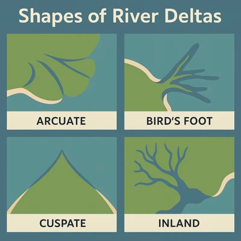
- Types of Deltas:
|
Type |
Key Characteristics |
Examples |
|
Arcuate |
Fan-shaped, convex seaward; formed from coarse sediments with balanced river and wave activity. |
Nile Delta (Egypt), Ganges Delta (India) |
|
Bird's Foot |
Resembles a bird's claw; formed from fine sediments by strong river flow into weak-wave environments. |
Mississippi Delta (USA) |
|
Cuspate |
Tooth-like shape; formed by strong waves pushing sediments along a straight shoreline. |
Tiber River (Italy) |
|
Estuarine |
Deposits form within a submerged river valley or existing estuary. |
Seine River (France), Narmada & Tapi (India) |
|
Lacustrine |
Formed where a river flows into a lake. |
Lough Leanne (Ireland) |
|
Abandoned |
An inactive lobe left when the river shifts its main course. |
Old Yellow River Delta (China), Western Ganga (Hooghly) Delta |
- Major River Deltas in India:
- Ganges-Brahmaputra Delta (the Sundarbans Delta): This is the world’s largest river delta, formed by the Ganges, Brahmaputra, and Meghna rivers, spanning West Bengal (India) and Bangladesh, and home to the world’s largest mangrove forest (Sundarbans).
- Godavari Delta: Formed by the Godavari River in Andhra Pradesh, this delta is one of the largest on India's eastern coast.
- Brahmani Delta: Formed by the Brahmani River and is situated in Odisha.
- Mahanadi Delta: Located in Odisha, formed by the Mahanadi River.
- Cauvery (Kaveri) Delta: Formed by the Cauvery River in Tamil Nadu, this delta is one of the most intensively cultivated regions in South India, often referred to as the "granary of South India."
- Significance of Deltas: Although river deltas occupy only 1% of the world’s land area, they support 350–500 million people (nearly 6% of the global population) and host 10 of the world’s 34 megacities.
- Deltas play a crucial role in agriculture, fisheries, ports, transport, maritime trade, and energy systems, yet are among the most fragile ecosystems on Earth.
Frequently Asked Questions (FAQs)
1. What is a River Delta?
A river delta is a depositional landform that develops at the mouth of a river where it discharges into a larger body of water, such as an ocean, sea, lake.
2. Which Indian river deltas are identified as high-risk in the Nature study?
Ganga-Brahmaputra, Brahmani, Mahanadi, Godavari, Cauvery, and Kabani deltas are experiencing significant subsidence.
3. Why are river deltas significant for India despite their vulnerability?
Though covering only 1 per cent of land area, deltas support agriculture, fisheries, ports, megacities, and livelihoods of millions, making their protection a national priority.
UPSC Civil Services Examination, Previous Year Question (PYQ)
Q. With reference to the Indus river system, of the following four rivers, three of them pour into one of them which joins the Indus directly. Among the following, which one is such a river that joins the Indus direct? (2021)
(a) Chenab
(b) Jhelum
(c) Ravi
(d) Sutlej
Ans: (d)
Q. Consider the following pairs (2019)
Glacier River
- Bandarpunch – Yamuna
- Bara Shigri – Chenab
- Milam – Mandakini
- Siachen – Nubra
- Zemu – Manas
Which of the pairs correctly matched?
(a) 1, 2 and 4
(b) 1, 3 and 4
(c) 2 and 5
(d) 3 and 5
Ans: (a)


