Geography
Delta
- 01 Jun 2020
- 11 min read
- Delta is a “depositional feature of a river formed at the mouth of the river. These are wetlands that form as rivers empty their water and sediment into another body of water, such as an ocean, lake, or another river.
- It is a characteristic feature of a river in its senile stage (old).
- Wetlands: It is defined as a transitional area between terrestrial and aquatic eco-systems where the water table is usually at or near the surface or the land is covered by shallow water.
- Mouth of River: It is the part of a river where the river enters into another river, a lake, a reservoir, a sea, or an ocean.
Formation of Delta
- A river moves more slowly as it nears its mouth, or end. This causes sediment, solid material carried downstream by currents, to fall to the river bottom.
- The slowing velocity of the river and the build-up of sediment allows the river to break from its single channel as it nears its mouth. The river forms a Deltaic lobe.
- A mature Deltaic lobe includes a distributary network. The series of smaller, shallower channels are called distributaries, and are branched off from the mainstream of the river.
- In a Deltaic lobe, heavier, coarser material settles first. Smaller, finer sediment is carried farther downstream.
- The finest material is deposited beyond the river's mouth. This material is called alluvium or silt.
- Silt is rich in nutrients that help microbes and plants, which leads to the growth of producers in the food web.
- As silt builds up, new land is formed. This is the Delta. A Delta extends a river's mouth into the body of water into which it is emptying.
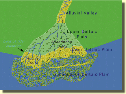
- The Deltas are typically made up of three parts: the upper Delta plain, the lower Delta plain, and the subaqueous Delta.
- The subaqueous part of a Delta is underwater. This is the most steeply sloping part of the Delta, and contains the finest silt. The newest part of the subaqueous Delta, furthest from the mouth of the river, is called the proDelta.
- The subaerial part of a Delta is above water. The subaerial region most influenced by waves and tides is called the lower Delta. The region most influenced by the river's flow is called the upper Delta.
Factors Affecting Delta Formation
- Numerous factors influence the character of a delta, the most important of which are:
- Climatic conditions
- Geologic setting
- Sediment sources in the drainage basin
- Tectonic stability
- River slope and flooding characteristics
- Intensities of depositional and erosional processes
- Tidal range and offshore energy conditions.
- Combinations of these factors and time give rise to the wide variety of modern deltas.
- The presence of a delta represents the continuing ability of rivers to deposit stream-borne sediments more rapidly than they can be removed by waves and ocean currents.
Types of Deltas
- On the basis of the shape, following are various types of Deltas:
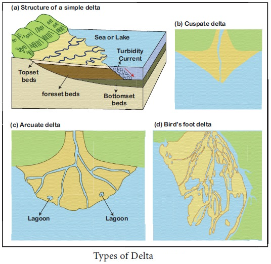
- Arcuate Delta: It is fan-shaped Delta. A bowed or curved Delta with the convex margin facing the body of water. Relatively coarse sediments are formed in this type of Delta. The river activity is balanced with the wind.
- Example, the River Nile Delta in Egypt and the Ganges Delta in India.
- Bird’s foot Delta: Named because it forms like a bird foot’s claw. This shape is created when the waves are weak and the river flow is stronger. They are formed due to deposition of finer materials by river water.
- Deposited alluvial material divides the river into smaller distributaries. Thus, this Delta rarely occurs along ocean coasts because the waves are often stronger than the river current.
- Such Delta is also called finger Delta.
- Example, Mississippi river Delta, the USA.
- Cuspate Deltas: It is formed where sediments are deposited onto a straight shoreline with strong waves. The waves push the sediments to spread outwardly creating the tooth-like shape.
- Example, Tiber River of Italy.
- Estuarine Delta: It is formed at the mouth of submerged rivers depositing down the sides of the estuary.
- Example, the Seine River of France, the Deltas of Narmada and Tapi (formerly Tapti) rivers of India.
- Lacustrine Delta: It is formed when a river flows into a lake. Example, Lough Leanne river Delta, Ireland.
- Truncated Delta: Sea waves and ocean currents modify and even destroy Deltas deposited by the river through their erosional work. Thus, eroded and dissected Deltas are called truncated Deltas.
- Abandoned Delta: When the river shifts its mouth, the Delta already made is left abandoned. Such a Delta is called an abandoned Delta.
- Example, Yellow river Delta, China and the Western part of Ganga Delta made by Hoogly river, India.
- Arcuate Delta: It is fan-shaped Delta. A bowed or curved Delta with the convex margin facing the body of water. Relatively coarse sediments are formed in this type of Delta. The river activity is balanced with the wind.
Importance of Deltas
- Human civilization: River Deltas have been important to humans for thousands of years because of their extremely fertile soils.
- Major ancient civilizations grew along Deltas such as those of the Nile and the Tigris-Euphrates rivers, with the inhabitants of these civilizations learning how to live with their natural flooding cycles.
- Agricultural activities: Delta land is important in agricultural use. These regions are one of the most agriculturally diverse and productive areas in the world.
- Example: Cauvery Delta in India and Sacramento-San Joaquin Delta in California.
- Economic activities: Deltas is a source of sand and gravel, used in highway, building and infrastructure construction.
- Deltas often host extensive industrial and commercial activities as well as agricultural land which are often in conflict.
- Some of the world's largest regional economies are located on Deltas such as the Pearl River Delta, Yangtze River Delta in China.
- Biodiversity hotspot: The river Deltas boast some of the most biodiverse systems on the planet.
- Example: Sunderbans forests, one of the richest biodiversity hotspots in India.
- It is essential that this unique ecosystem remains as a healthy habitat for the many species of plants, animals, insects, fish and some rare, threatened or endangered species.
- Act as a buffer region: The Deltas region provides a buffer for cyclones, as open land often stands to weaken the impact of storms as they travel toward larger, more populated areas.
- The Mississippi River Delta, for example, buffers the impact of potentially strong hurricanes in the Gulf of Mexico.
Threat to Delta
- Dam construction: Extensive river management through the use of dams threatens Deltas. River management involves monitoring and administering a river's flow.
- It increases the amount of land available for agricultural or industrial development, and controls access to water for drinking, industry, and irrigation.
- The actions reduce the flow of sediment and, thus, the growth of land.
- The Nile Delta is also shrinking as a result of the Aswan Dam and other river management techniques.
- Seawater intrusion: In the Krishna Delta widespread seawater intrusion is transforming the fresh groundwater to brackish/saline water.
- With more dams across the Krishna and the Godavari rivers under construction, together with increasing groundwater and hydrocarbon extraction within the Delta region, the health of the ecosystem and the wellbeing of the millions of people inhabiting these Deltas are at risk.
- Climate change: Besides subsidence and sea level rise, more extreme weather events on Deltas are resulting in more severe floods, longer duration droughts and higher temperatures.
- The frequency, duration, and strength of cyclones causing floods seem to be increasing, especially in the Asian Deltas (e.g. Irrawaddy and Ganges–Brahmaputra–Meghna), and in the Mississippi River Delta.
- Climate change seems to be causing higher peak flows and lower low flows in the Rhine-Meuse and Danube Deltas. The extreme variability of the climate is impacting its hydrology as is the increasing average and extreme temperatures.
- Pollution: Inadequately treated sewage and fertilizer and other nutrient runoff from agricultural and urban areas are the causes of eutrophication in the Delta region.
- The water quality problems in the world are leading to a hypoxic zone in the area adjacent to the major Deltas. Example: Gulf of Mexico.
Important Facts
- The Ganges–Brahmaputra Delta, which spans most of Bangladesh and West Bengal, India empties into the Bay of Bengal, is the world's largest delta.
- Sundarban, a world heritage site lies in Ganges delta, also contains the world’s largest area of mangrove forests.
- The Selenga River delta in Russia is the largest delta emptying into a body of fresh water (Lake Baikal).


