Important Facts For Prelims
Groundwater loss for the Indian Ganga Basin
- 06 Feb 2023
- 7 min read
Why in News?
A recent report, "Estimation of groundwater storage loss for the Indian Ganga Basin using multiple lines of evidence," estimates that groundwater storage levels in the Ganga basin have been declining by 2.6 centimeters per year.
- The Ganga Basin’s aquifers are one of the largest reservoirs of groundwater in the world.
What are the Findings?
- The average groundwater levels have been declining at a rate of 2.6 cm year-1 between 1996-2017.
- The analysis of satellite data from the Gravity Recovery and Climate Experiment (GRACE), yielded an average loss of 1.7 cm per year-1.
- GRACE satellites, launched in 2002, assess Earth’s water reservoirs over land, ice and ocean.
- The average storage decline in Uttar Pradesh, Bihar and West Bengal was estimated to be roughly 2 cm year−1, 1 cm year−1 and 0.6 cm year−1, respectively.
- The impacts were more pronounced in Rajasthan, Haryana and Delhi, with average storage declines of roughly 14 cm year−1, 7.5 cm year−1 and 7.2 cm year−1, respectively.
- West and southwest areas, including agriculturally intensive regions and urban areas like Delhi and Agra, took the biggest hit.
- Delhi and Haryana have high groundwater abstraction rates, which explains the steep decline.
- The Brahmaputra basin shows more groundwater level reduction than the Ganga and Indus basins.
What is the Ganga River System?
- It is the longest river of India flowing over 2,510 km of mountains, valleys and plains and is revered by Hindus as the most sacred river on earth.
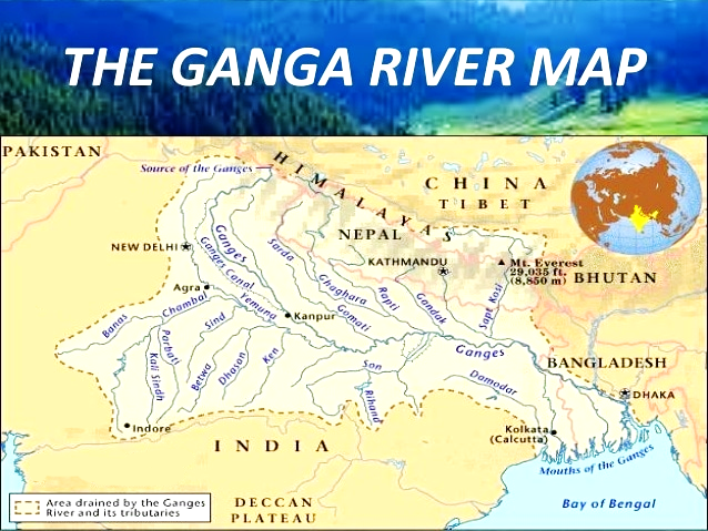
- The Ganga basin outspreads in India, Tibet (China), Nepal and Bangladesh over an area of 10,86,000 Sq.km.
- In India, it covers states of Uttar Pradesh, Madhya Pradesh, Rajasthan, Bihar, West Bengal, Uttarakhand, Jharkhand, Haryana, Chhattisgarh, Himachal Pradesh and Union Territory of Delhi draining nearly 26% of the total geographical area of the country.
- It originates in the snowfields of the Gangotri Glacier in the Himalayas.
- At its source, the river is called as the Bhagirathi. It descends down the valley upto Devprayag where after joining another hill stream Alaknanda, it is called Ganga.
- The principal tributaries joining the river from right are the Yamuna and the Son.
- The Ramganga, the Ghaghra, the Gandak, the Kosi and the Mahananda join the river from left. The Chambal and the Betwa are the two other important sub- tributaries.
- The Ganges River Dolphin is an endangered animal that specifically habitats this river.
- The Ganga joins the Brahmaputra (Jamuna) in Bangladesh and continues its run under the name Padma.
- The Ganga widens out into the Ganges Delta in the Sundarbans swamp of Bangladesh, before it ends its journey by emptying into the Bay of Bengal.
UPSC Civil Services Examination Previous Year Question (PYQ)
Prelims
Q. Consider the following statements: (2020)
- 36% of India’s districts are classified as “overexploited” or “critical” by the Central Ground Water Authority (CGWA).
- CGWA was formed under the Environment (Protection) Act.
- India has the largest area under groundwater irrigation in the world.
Which of the statements given above is/are correct.
(a) 1 only
(b) 2 and 3 only
(c) 2 only
(d) 1 and 3 only
Ans: (b)
- Based on groundwater levels, areas across the country are split into three categories: Over-exploited, Critical and Semi critical. The first refers to groundwater being extracted more than what’s recharged i.e. extraction is more than 100%. Critical where the groundwater taken out is 90-100% of what’s recharged and semi-critical where extraction rate is 70%-90%.
- As per the report ‘National Compilation on Dynamic Groundwater Resources of India, 2017’ of CGWA, out of the total 6881 assessment units (Blocks/ Mandals/Talukas) in the country, 1186 units in various States (17%) have been categorized as ‘OverExploited’, 313 units (5%) are ‘Critical’, and 972 are semi-critical units (14%). Hence, statement 1 is not correct.
- Note: As per National Compilation on Dynamic Groundwater Resources of India 2020; Out of the total 6965 assessment units (Blocks/ Mandals/ Talukas/ Firkas) in the country, 16 % have been categorized as ‘Over-exploited, 4 % as Çritical, 15 % as Semi-critical and 64 %) as ‘Safe‘ units. Apart from these, there are 97 (1%) assessment units, which have been categorised as ‘Saline’.
- The Central Ground Water Authority (CGWA) was constituted under Section 3(3) of the Environment (Protection) Act, 1986 to regulate, control development and management of ground water resources. Hence, statement 2 is correct.
- As per report of Food and Agriculture Organization (FAO) of UN, the countries with the largest extent of areas equipped for irrigation with groundwater, in absolute terms, are India (39 million ha), China (19 million ha) and the USA (17 million ha). Hence, statement 3 is correct. Therefore, option (b) is the correct answer.
Mains
Q1. India is well endowed with fresh water resources. Critically examine why it still suffers from water scarcity. (2015)
Q2. The idealsolution of depleting ground water resources in India is water harvesting system”. How can it be made effective in urban areas? (2018)
Q3. Discuss the Namami Gange and National Mission for Clean Ganga (NMCG) programmes and causes of mixed results from the previous schemes. What quantum leaps can help preserve the river Ganga better than incremental inputs? (2015)


