Geography
Re-measuring Mount Everest
- 16 Sep 2020
- 6 min read
Why in News
China and Nepal are soon expected to announce Mount Everest’s latest official height.
- In 2019, both countries agreed to re-measure the elevation of the world’s highest mountain and announce the findings together.
Key Points
- About:
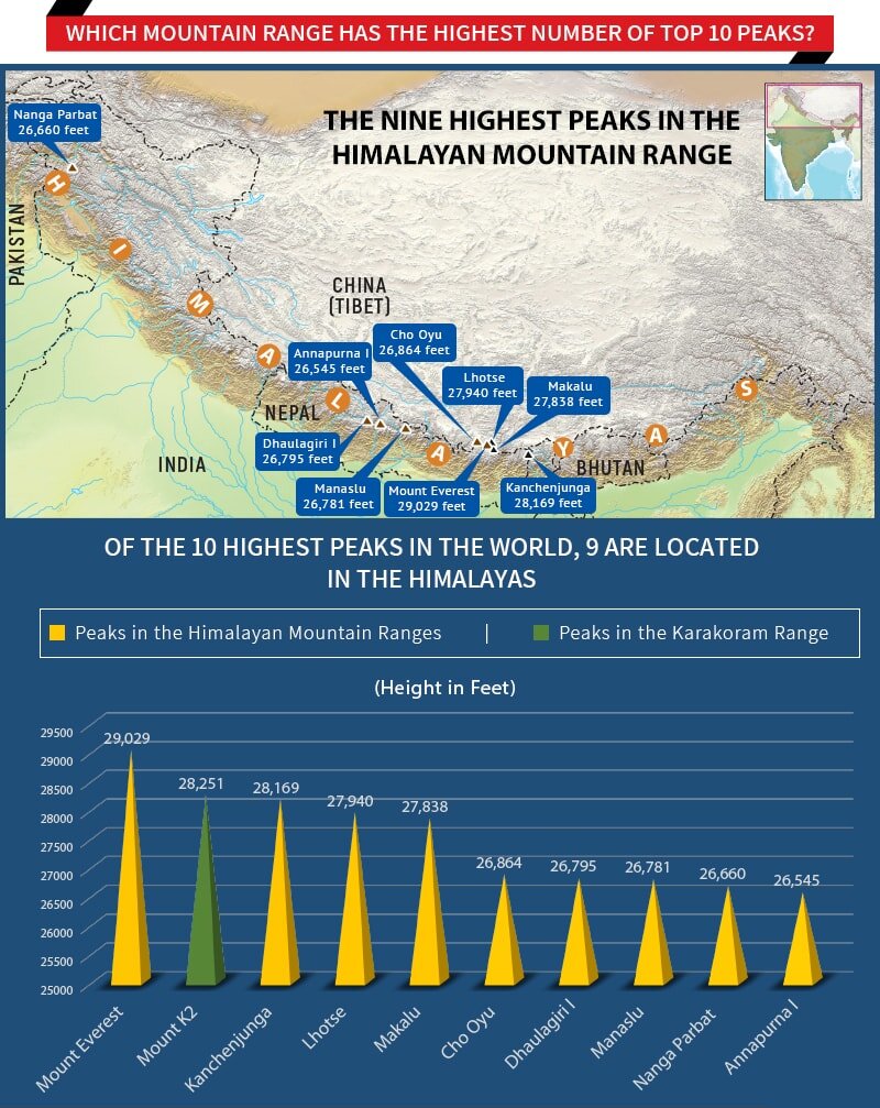
- Mount Everest (also called Sagarmatha in Nepal) is Earth’s highest mountain above sea level, located in the Himalayas between China and Nepal with their borders running across its summit point.
- Its current official elevation is 8,848m which places it more than 200m above the world’s second-highest mountain, K2, which is 8,611m tall and located in Pakistan-occupied Kashmir.
- Mount Everest gets its English name from Sir George Everest, a colonial-era geographer who served as the Surveyor General of India in the mid-19th century.
- It was first scaled in 1953 by the Indian-Nepalese Tenzing Norgay and New Zealander Edmund Hillary.
- First Survey of Everest:
- The first effort was carried out in 1847 by a team led by Andrew Waugh, Surveyor General of India.
- The survey was based on trigonometric calculations and is known as the Great Trigonometric Survey of India.
- The team discovered that ‘Peak 15’ (as Mount Everest was referred to then) was the highest mountain, contrary to the then-prevailing belief that Mount Kanchenjunga (8,582m and the 3rd highest peak in the world now) was the highest peak in the world.
- The first effort was carried out in 1847 by a team led by Andrew Waugh, Surveyor General of India.
- Need for Re-measurement:
- Everest’s current official height has been widely accepted since 1956 when the figure was measured by the Survey of India.
- However, the height of a summit changes due to tectonic activities like the 2015 Nepal earthquake.
- Its measurement over the decades has also depended on who was surveying.
- Previous measurements of the mountain were by Indian, American or European surveyors.
- The joint effort represents national pride for Nepal which will come up with its own findings on the height.
- Everest’s current official height has been widely accepted since 1956 when the figure was measured by the Survey of India.
Survey of India
- It is the National Survey and Mapping Organisation of the country under the Department of Science and Technology.
- It was established in 1767 and is the oldest scientific department of the Government of India.
- Headquarters: Dehradun, Uttarakhand.
- It acts as an adviser to the Government of India on all survey matters, viz Geodesy, Photogrammetry, Mapping and Map Reproduction.
- Geodesy is the science of accurately measuring and understanding the Earth's geometric shape, orientation in space and gravity field.
- Photogrammetry is the science of making measurements from photographs.
Himalayas
- Origin: The northward drift of the Indo-Australian plate resulted in its collision with the much larger Eurasian Plate. Due to which, the sedimentary rocks which were accumulated in the geosyncline known as the Tethys were folded to form the mountain system of western Asia and Himalaya.
- Features:
- The Himalayas are geologically young and structurally folded mountains and represent the loftiest and one of the most rugged mountain barriers of the world.
- They form an arc, which covers a distance of about 2,400 km. Their width varies from 400 km in Kashmir to 150 km in Arunachal Pradesh.
- Orientation:
- The general orientation of these ranges is from northwest to the southeast direction in the northwestern part of India.
- Himalayas in the Darjeeling and Sikkim regions lie in an east west direction.
- In Arunachal Pradesh they are from southwest to the northwest direction.
- In Nagaland, Manipur and Mizoram, they are in the north south direction.
- The Himalayan mountains consist of three parallel ranges in longitudinal extent:
- Great Himalaya or Himadri: It is the northernmost and the most continuous range consisting of the loftiest peaks with an average height of 6,000 m. World’s highest peaks are located in it.
- Lesser Himalaya or Himachal: To the south of Himadri, it is the most rugged mountain system and is known as Himachal or lesser Himalaya. The altitude varies between 3,700 and 4,500 m. It is well known for its hill stations like Kashmir, Kangra and Kullu Valleys.
- Shiwalik: It is the southernmost range with an altitude varying between 900 and 1100 m. These ranges are composed of unconsolidated sediments brought down by rivers from the main Himalayan ranges located farther north.
- There are large-scale regional variations within the Himalayas. On the basis of relief, alignment of ranges and other geomorphological features, the Himalayas can be divided into the following subdivisions:
- Kashmir or Northwestern Himalayas.
- Himachal and Uttaranchal Himalayas.
- Darjeeling and Sikkim Himalayas.
- Arunachal Himalayas.
- Eastern Hills and Mountains.


