International Relations
China Not Leaving Hot Springs & Gogra Post
- 19 Apr 2021
- 6 min read
Why in News
Recently, during the 11th round of discussions between the senior military commanders of India and China to resolve the standoff in eastern Ladakh, China refused to vacate two of the four original friction points.
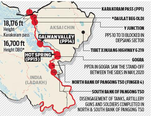
- At two friction points, Patrolling Point 15 (PP15) in Hot Springs, and PP17A near Gogra Post, China still has a platoon-level strength each, along with vehicles.
- Other two are the Galwan valley and the Depsang plains.
Key Points
- Patrolling Point 15 and 17A:
- Along the Line of Actual Control (LAC) between India and China, Indian Army has been given certain locations that its troops have access to patrol the area under its control.
- These points are known as patrolling points, or PPs, and are decided by the China Study Group (CSG).
- CSG was set-up in 1976, when Indira Gandhi was the prime minister, and is the apex decision-making body on China.
- Barring certain areas, like Depsang Plains, these patrolling points are on the LAC, and troops access these points to assert their control over the territory.
- It is an important exercise since the boundary between India and China is not yet officially demarcated.
- LAC is the demarcation that separates Indian-controlled territory from Chinese-controlled territory.
- PP15 and PP17A are two of the 65 patrolling points in Ladakh along the LAC.
- Both these points are in an area where India and China largely agree on the alignment of the LAC.
- PP15 is located in an area known as the Hot Springs, while PP17A is near an area called the Gogra post.
- Location of Hot Springs and Gogra Post:
- Hot Springs is just north of the Chang Chenmo river and Gogra Post is east of the point where the river takes a hairpin bend coming southeast from Galwan Valley and turning southwest.
- The area is north of the Karakoram Range of mountains, which lies north of the Pangong Tso lake, and south east of Galwan Valley.
- Importance:
- The area lies close to Kongka Pass, one of the main passes, which, according to China marks the boundary between India and China.
- India’s claim of the international boundary lies significantly east, as it includes the entire Aksai Chin area as well.
- Hot Springs and Gogra Post are close to the boundary between two of the most historically disturbed provinces (Xinjiang and Tibet) of China.
- The area lies close to Kongka Pass, one of the main passes, which, according to China marks the boundary between India and China.
Pangong Tso lake
- Pangong Lake is located in the Union Territory of Ladakh.
- It is situated at a height of almost 4,350m and is the world’s highest saltwater lake.
- Extending to almost 160km, one-third of the Pangong Lake lies in India and the other two-thirds in China.
Galwan Valley
- The valley refers to the land that sits between steep mountains that buffet the Galwan River.
- The river has its source in Aksai Chin, on China’s side of the LAC, and it flows from the east to Ladakh, where it meets the Shyok river on India’s side of the LAC.
- The valley is strategically located between Ladakh in the west and Aksai Chin in the east, which is currently controlled by China as part of its Xinjiang Uyghur Autonomous Region.
Chang Chenmo River
- Chang Chenmo River or Changchenmo River is a tributary of the Shyok River, part of the Indus River system.
- It is at the southern edge of the disputed Aksai Chin region and north of the Pangong Lake basin.
- The source of Chang Chenmo is near the Lanak Pass.
Kongka Pass
- The Kongka Pass or Kongka La is a low mountain pass over a hill that intrudes into the Chang Chenmo Valley. It is in the disputed India-China border area in Ladakh.
Karakoram Range
- It is also known as Krishnagiri which is situated in the northernmost range of the Trans-Himalayan ranges. It forms India's frontiers with Afghanistan and China.
- It extends eastwards from the Pamir for about 800 km. It is a range with lofty peaks [elevation 5,500 m and above].
- Some of the peaks are more than 8,000 metre above sea level. K2 (8,611 m)[Godwin Austen or Qogir] is the second highest peak in the world and the highest peak in the Indian Union.
- The Ladakh Plateau lies to the north-east of the Karakoram Range.


