Places in News-India
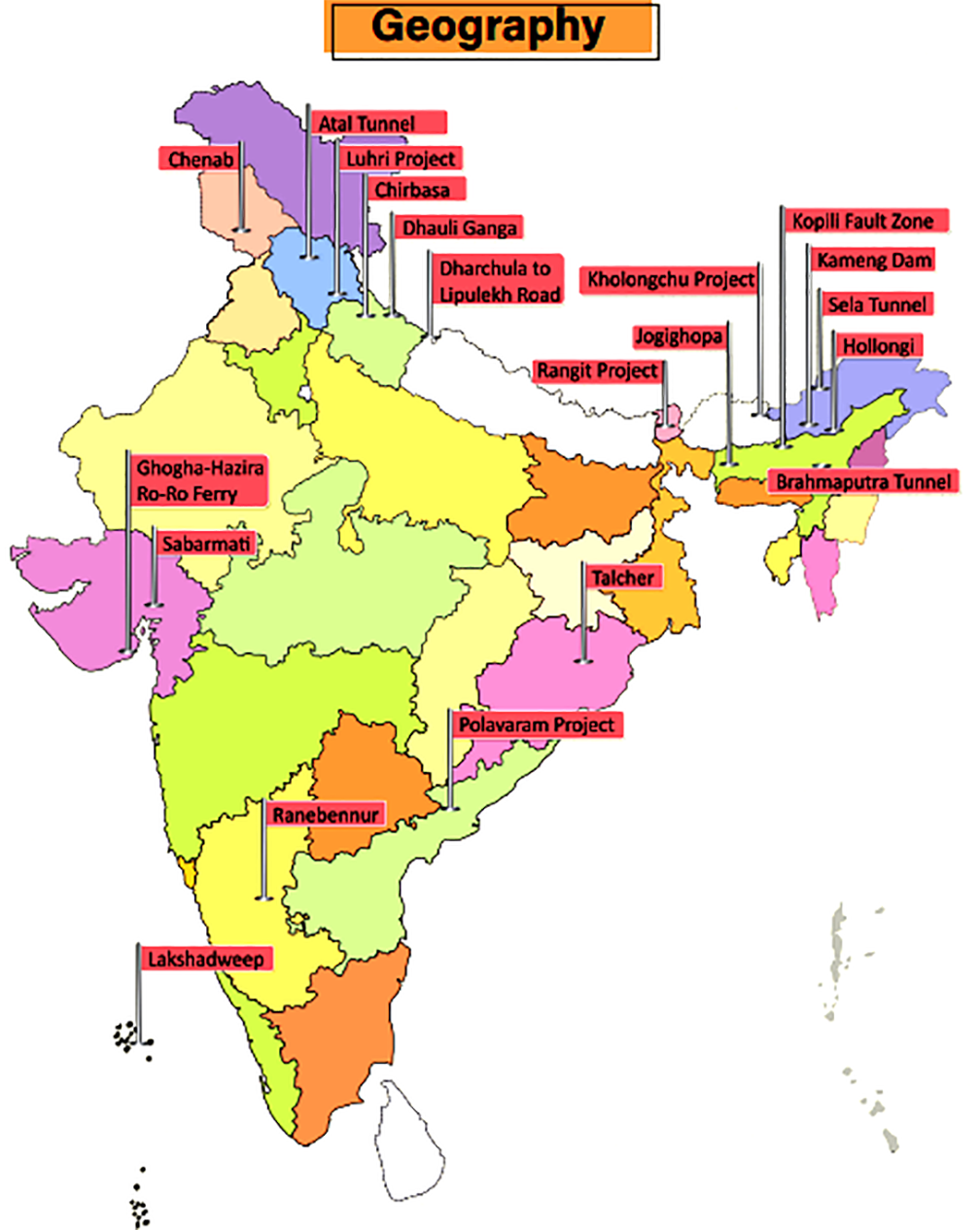
Atal Tunnel
Context
Atal Tunnel was inaugurated at Rohtang at an altitude of above 3,000 metres in Himachal Pradesh.
Key Points
- The 9.02 km-long tunnel, built by the Border Roads Organisation (BRO), is the world’s longest highway tunnel. It connects Manali to Lahaul-Spiti valley.
- The tunnel, also significant from the military logistics viewpoint, will provide better connectivity to the armed forces in reaching Ladakh.
Brahmaputra Tunnel
Context
The Central government has given in-principle approval for the construction of an underwater tunnel in the Brahmaputra river in Assam.
Key Points
- The tunnel will connect Gohpur (NH-54) with Numaligarh (NH-37) in Assam.
- The tunnel will be of strategic importance as it will provide round the year connectivity between the North-Eastern states of Assam and Arunachal Pradesh.
- The National Highways and Infrastructure Development Corporation Limited (NHAIDCL) has roped in the US-based firm Louis Berger for the same.
Chenab River
Context
The world’s highest railway bridge is being built over the Chenab river in Jammu and Kashmir.
About Chenab
- It is formed by the union of two headwaters, Chandra and Bhaga, which rise in the upper Himalayas in the Lahaul and Spiti districts of Himachal Pradesh.
- After receiving the Jhelum river near Trimmu, the Chenab empties into the Sutlej river, a tributary of the Indus river.
- The Chenab river was called Asikni in the Rigveda meaning that it was seen to have dark-coloured waters.
- Salal Dam is a 690 MW hydroelectric power project on Chenab river near Reasi, Jammu & Kashmir.
- The Ratle Hydroelectric Plant and Kiru Hydroelectric Power Project are proposed to be built over the Chenab.
Chirbasa
Context
Black Carbon research project has been established in Chirbasa.
About Chirbasa
- It is located on the banks of River Bhagirathi in the Gangotri National Park (Uttarakhand).
- This place at the altitude of 3,500 meters falls on the famous trekking route of Gomukh and Tapovan.
- Scientists have been monitoring black carbon in the region and especially the glaciers through two weather stations on the way to Gangotri glacier - namely Chirbasa and Bhojbasa (a few km ahead of Chirbasa).
Kameng Dam
Context
Recently, the Kameng Hydropower Project got fully commissioned.
About Kameng Project
- Situated in West Kameng District of Arunachal Pradesh, the Kameng Hydroelectric Project (600 MW) is a run-of-the-river scheme that will utilize the flows from Bichom and Tenga Rivers (both tributaries of the River Kameng).
- Kameng River
- It originates in Tawang district from the glacial lake below snow-capped Gori Chen mountain.
- It becomes a braided river in its lower reaches and is one of the major tributaries of the Brahmaputra River.
- The Kameng forms the boundary between East Kameng and West Kameng districts and is also the boundary between the Sessa and Eaglenest sanctuaries to its west and the Pakke Tiger Reserve to the east.
- Kameng Hydroelectric Project is the largest hydropower plant in the northeastern region.
Kholongchu Hydroelectric Project
Context
India and Bhutan have signed a pact for the construction of Kholongchhu joint venture hydroelectric project in Bhutan.
India-Bhutan Hydro Projects
- The 600 MW run-of-the-river project, Kholongchhu, is located on the lower course of the Kholongchhu river in Trashiyangtse district in eastern Bhutan.
- Currently, four hydroelectric projects of bilateral cooperation totalling over 2,100 MW, are operational in Bhutan. These include:
- Chukha Hydro Electric project
- Kurichu Hydro Electric project
- Tala Hydro Electric Project
- Mangdechhu HydroElectric Project
- Besides, both sides are also in process of expediting the completion of other ongoing projects including the Punatsangchhu Project.
Luhri Hydropower Project
Context
Recently, the Union Cabinet approved the building of the Luhri Hydropower Project.
About
- The Luhri Project is situated in Shimla and Kullu districts of HImachal Pradesh.
- It is being implemented by the Satluj Jal Vidyut Nigam Limited (SJVNL) on Build-Own-Operate-Maintain (BOOM) basis.
Rangit Power Project
Context
The stressed asset Rangit-IV Hydroelectric Project of Jal Power Corporation Ltd (JPCL) has been handed over to the National Hydro Power Corporation (NHPC) Ltd.
About
- Rangit dam is a run-of-the-river power project on the Rangit river, a major tributary of the Teesta river in Sikkim.
- The Rangit river arises from the Talung glacier and it meets the Teesta river at Melli in Sikkim itself.
Dharchula to Lipulekh Road
Context
The Border Roads Organisation (BRO) has completed the construction of a road from Dharchula to Lipulekh along the China Border, famously known as Kailash-Mansarovar Yatra Route.
About the Road
- The road has been built from Ghatibagar in Dharchula to Lipulekh near the border with China.
- The tough Himalayan terrain beginning from Mangti camp near Tawaghat to Gunji in Vyans valley, and Indian security posts situated near Indo-China border, are now accessible by a concrete road.
- The road ends at the 17,000 feet high Lipulekh pass. From there, Mount Kailash is located around 97 km north of the pass in Tibet.
- The Lipulekh pass, close to the tri-junction of India-China-Nepal, is the lowest point in this section of the high Himalayas.
Dhauli Ganga River
Context
Recently, Dhauli Ganga river in Uttarakhand witnessed glacial floods.
About Dhauli Ganga
- Originating in the vicinity of the Niti Pass (Uttarakhand), the Dhauli Ganga flows in a meandering course, which takes it through the Nanda Devi National Park.
- Dhauli Ganga, which merges with Alaknanda, is one of the several tributaries of the Ganga, as the holy river flows down from the Himalayas and snakes its way through the plains.
- Dhauli Ganga is joined by the Rishi Ganga river at Raini where the disaster at the power project dam took place.
- The river takes a V turn and continues to flow in the opposite direction, toward north, as Dhauli Ganga, through Tapovan, until it is joined by Alaknanda river at Vishnuprayag near Joshimath.
- Dhauli Ganga is one of the important tributaries of Alaknanda, the other being the Nandakini, Pindar, Mandakini and Bhagirathi.
Ghogha - Hazira Ro-Ro Ferry
Context
Last year, the Prime Minister virtually inaugurated the Ghogha-Hazira Ro-Pax ferry service in Gujarat.
About Ghoga-Hazira ferry
- The ferry moves between Ghogha (a fishing hamlet and an old port) and Hazira (a commercial greenfield port).
- The service was launched to bridge the Gulf of Khambhat by providing a sea route to passengers travelling to and fro between Bhavnagar (located on the western side of the Gulf) and South Gujarat (on the east).
Hollongi
Context
Airports Authority of India (AAI) planned to develop a greenfield airport at Hollongi.
About Hollongi
- Hollongi is located in Arunachal Pradesh. It lies south of the state capital Itanagar.
- This airport, when operational, will service Arunachal Pradesh's capital Itanagar. The closest airport to the state capital is currently Lilabari airport in Assam, situated 80 kilometres away.
Jogighopa
Context
The Union Minister for Road Transport and Highways has laid the foundation stone for the country's first Multi-Modal Logistics Park (MMLP) at Jogighopa in Assam.
About Jogighopa
- Jogighopa is a town located on the northern bank of the Brahmaputra River. It has a combined road-rail bridge, called Naranarayan Setu, over the Brahmaputra river.
- The city has the remains of the five rock-cut caves, examples of Salasthambha period architecture being preserved by the Archaeological Survey of India (ASI).
- Under its MMLP project, the development includes railway sidings, container terminals, warehousing, non-cargo processing, a truck terminal, common facilities, support infrastructure and equipment.
- With this, Jogighopa will become India’s gateway to South-East Asia as well as the rest of the North-East with road, rail, waterways and air transport facilities under the MMLP.
- The MMLP at Jogighopa will be the country’s first international Multi-Modal Logistic Park under the Bharatmala Project of the Ministry of Road Transport and Highways.
Kopili Fault Zone
Context
The Kopili Fault Zone closer to Himalayan Frontal Thrust in Assam recently witnessed a powerful earthquake.
About Kopili Fault Zone
- The Kopili fault zone is a 300 km long and 50 km wide lineament (linear feature) extending from the western part of Manipur up to the tri-junction of Bhutan, Arunachal Pradesh and Assam.
- The area is seismically very active, falling in the highest Seismic Hazard Zone V associated with collisional tectonics where Indian plate subducts beneath the Eurasian Plate.
- Subduction is a geological process in which one crustal plate is forced below the edge of another.
- Squeezed between the subduction and collision zones of the Himalayan belt and Sumatran belt, the North East is highly prone to earthquake occurrences.
- A tectonic depression filled up by the alluvium of the Kopili river and its tributaries, the Kopili fault zone has witnessed many seismic activities in the past including the 1869 earthquake (7.8 magnitude) and the 1943 earthquake (7.3 magnitude).
Lakshadweep
Context
The entire Lakshadweep group of islands has been declared as an organic agricultural area under the Participatory Guarantee System (PGS) of India.
About Lakshadweep
- Lakshadweep is the first Union Territory to become 100% organic as all farming is carried out without the use of synthetic fertilisers and pesticides, etc. Earlier in 2016, Sikkim became India’s first 100% organic State.
- It is an archipelago of 36 islands in the Arabian Sea, located off of the mainland's southwestern coast.
- The Aminidivi subgroup of islands (consisting of Amini, Keltan, Chetlat, Kadamat, Bitra, and Perumal Par) and the Laccadive subgroup of islands (comprising mainly Androth, Kalpeni, Kavaratti, Pitti, and Suheli Par) have a submarine connection between them through Pitti Bank.
- Together with Minicoy Island, a lonely atoll located at the southern end of the 200-km-broad Nine Degree Channel, they form the Coral Islands of India in the Arabian Sea.
Polavaram Irrigation Project
Context
The Polavaram Project is an under-construction multi-purpose irrigation project on the Godavari river in Andhra Pradesh.
About Polavaram
- Polavaram or Prolavaram is a village in the West Godavari district of Andhra Pradesh.
- The Papi Hills and Polavaram Project are the major landmarks near the village. The project has been accorded national project status by the Government of India.
- This area was under the rule of Kamma kings of Musunuri Nayaks. Kamma king Musunuri Prolayya, in 1330 donated Polavaram village to Brahmins. Polavaram means, Prola is Prola and Varam is donation.
- The Polavaram Project has been a contentious issue in various terms like its financing, rehabilitation of affected people and affected areas of states other than Andhra Pradesh, i.e. Odisha and Telangana.
Ranebennur
Context
One Common Facility Centre for wool processing has been proposed to be established at Ranebennur (Karnataka).
About Ranebennur
- Ranebennur is a city in Haveri district in Karnataka. It is home to a rich commodity market. Commodities like cotton yarn, cottonseed, oilseeds, red chilli, betel nut, and betel leaf are traded.
- One of Karnataka's most important rivers – the Tungabhadra – flows along the southern border of Ranebennur taluk.
- Another river, Kumadvathi, which originates from Madagh Masur Lake, enters Ranebennur, and joins the Tungabhadra river.
- Ranebennur Blackbuck Sanctuary is home to blackbuck, Great Indian Bustard and wolves. The Great Indian Bustard was last spotted in 2005 and may have become locally extinct.
Sabarmati River
Context
Ahmedabad Municipal Corporation has been working towards development of Sabarmati riverfront.
About Sabarmati river
- The Sabarmati river is a monsoon-fed river that flows north-south through Ahmedabad, bisecting the city into its western and eastern halves.
- It is one of the major west-flowing rivers that originates in the Aravalli Range of the Udaipur District of Rajasthan. It meets the Gulf of Khambhat of the Arabian Sea.
- The river traverses three geomorphic zones: rocky uplands, middle alluvial plains, and lower estuarine zone.
- The Dharoi dam is located on this river.
Sela Tunnel
Context
Sela tunnel is an under-construction road which will ensure all-weather connectivity between Assam and Arunachal Pradesh.
About Sela tunnel
- It is located at a height of 13,700 feet and is being executed by Border Roads Organisation (BRO).
- The tunnel once complete will provide all-weather connectivity to Tawang and forward areas as it is going to avoid all the avalanche prone and snowfall areas.
- It will reduce the travelling time from Tezpur to Tawang by more than an hour and boost tourism and related economic activities in the region.
- The tunnels would ensure that the 171 km road between Bomdila and Tawang remains accessible in all weather conditions.
Talcher
Context
India's first coal gasification-based fertiliser plant is being set up at Talcher.
About Talcher
- Talcher (Odisha) is situated on the bank of the river Brahmani.
- In the 14th century, Panchdiha Chasa who were mainly a farmer community came to this fertile area and started living here. The King of Talcher Padmanabha Birabara Harichandan renamed the state as Talcher after the name of the family Goddess Taleswari.
- Talcher is also named as the City of Black Diamond or Coal City of Odisha and is the largest coalfield of India.
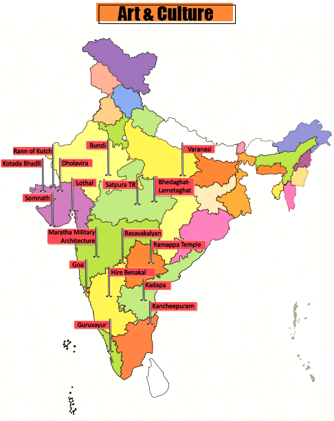
Six Heritage Sites Added to Tentative List of UNESCO
In news
- Six sites have been added to India’s tentative list of UNESCO World Heritage Sites (WHS). A Tentative List is an inventory of those properties which each State/Country party intends to consider for nomination further in WHS.
- The six sites are:
- Ganga ghats in Varanasi,
- Temples of Kancheepuram in Tamil Nadu,
- Satpura Tiger Reserve in Madhya Pradesh,
- Maratha military architecture in Maharashtra,
- Hire Bengal megalithic site in Karnataka and
- Bhedaghat-Lameta Ghat of Narmada Valley in Madhya Pradesh.
Architectural Heritage of Bundi
In news
A recent webinar series by the Ministry of Tourism, titled ‘Dekho Apna Desh’, focused on the architectural heritage of Bundi, Rajasthan.
About Bundi
- Sukh Mahal, Raniji ki Baori, Taragarh Fort, 84 Pillared Cenotaph, Garh Palace, Badal Mahal, Chhatr Palace, etc. are some of the notable pieces of architectural heritage of Bundi.
- Bundi was once ruled by the Hada Chauhans. Many historians claim that it was once the capital of the great Hadoti Kingdom, which was renowned for its art and sculpture.
- The Hadoti region is named after the Hada Chauhans, who ruled this area around Kota and Bundi.
- In ancient times, the area around Bundi was apparently inhabited by various local tribes, of which the Parihar Meena and Bhil Meena were prominent.
- Later, the region was governed by Rao Deva, who took over Bundi from Jaita Meena in 1242, renaming the surrounding area as Haravati or Hadoti.
- For the next two centuries, the Hadas of Bundi were the vassals of the Sisodias of Mewar and ruled by the title of Rao until 1569, after Emperor Akbar.
Dholavira
In news
Dholavira, the archaeological site of a Harappan-era city, received the UNESCO World Heritage Site tag, recently.
About Dholavira
- The ancient city of Dholavira, the southern centre of the Harappan Civilization, is situated on the arid island of Khadir in the State of Gujarat.
- Occupied between 3000-1500 BCE, it is one of the best-preserved urban settlements from the period in Southeast Asia, comprising a fortified city and a cemetery.
- While Dholavira became the fourth site from Gujarat and 40th from India to make the list, it is the first site of the ancient Indus Valley Civilisation (IVC) in India to get the tag.
- Other 3 sites from Gujarat in the WHS include Champaner in Pavagadh, Rani Ki Vav in Patan and the Historic City of Ahmedabad.
Goa
In news
The Government of Goa has released a short film on Chhatrapati Shivaji on the occasion of the anniversary of the Maratha king’s coronation day highlighting the history of Goa and Shivaji’s role in fighting the Portuguese.
About Goa
- Goa lies within the region known as the Konkan and is geographically separated from the Deccan highlands by the Western Ghats.
- It is India's smallest state by area and has the highest GDP per capita among all Indian states.
- Major rivers are Zuari, Mandovi, Terekhol, Chapora, Galgibag, etc.
- The Goa, Daman and Diu Official Language Act, 1987 makes Konkani in the Devanagari script the sole official language of Goa, but provides that Marathi may also be used "for all or any of the official purposes".
Guruvayur, Kerala
In news
A Tourist Facilitation Centre facility was constructed under the project “Development of Guruvayur, Kerala” - under PRASAD Scheme of the Ministry of Tourism.
About Guruvayur
- This place is famous for Guruvayur temple dedicated to Lord Guruvayoorappan, a form of Lord Vishnu. The temple is also known as Guruvayur Sri Krishna Temple.
- The famous festivals of the temple are Guruvayur Ekadashi, Chembai Sangeetholsavam, etc.
- The temple tank (pond) on the northern side of the temple is called Rudratheertham.
- In the 14th century Tamil literature 'Kokasandesam', references about a place called Kuruvayur can be found.
Kadapa, Andhra Pradesh
Context
A rare inscription dating back to the Renati Chola reign (8th century CE) has been unearthed in a remote village of the Kadapa district of Andhra Pradesh.
About Kadapa
- The city is surrounded on three sides by the Nallamala and Palkonda Hills.
- Kadapa has been under different rulers in its history, including the Nizams and Cholas, the Vijayanagara Empire and the Kingdom of Mysore.
- The discovered inscription was written in archaic Telugu. It seems to throw light on the record of a gift of six Marttus (a measuring unit) of land gifted to a person Sidyamayu, one of the Brahmins serving the temple at Pidukula village.
Kakatiya Rudreshwara Temple
In news
The Kakatiya Rudreshwara Temple, also known as the Ramappa Temple, in Telangana was recently inscribed as a UNESCO World Heritage Site.
About Ramappa Temple
- The Ramappa temple is named after its sculptor Ramappa. Constructed in 1213 CE under the Kakatiya dynasty, it took almost 40 years to be completed.
- The temple was built during the rule of the Kakatiya king Gajapati Deva under the supervision of Recherla Rudra Reddy, who was the chief of the Kakatiya army.
- It is the first and only monument from Andhra Pradesh and Telangana to make it to the list of WHS.
- What really sets the temple apart are its ‘floating bricks’ that were used to build the ‘Shikara’ roof of the temple.
- The bricks are so light that they can float on water.
- The density of the bricks is between 0.85 to 0.9 grams per cubic centimetre, whereas the density of water is 1 g/cc.
- Any usual brick has a density of around 2.2 g/cc.
Kotada Bhadli
In news
Recently, a pottery-based study has found that dairy products were being produced by the Harappans as far back as 2500 BCE.
About the finding
- Kotada Bhadli is a small village settlement, measuring about 3.11 ha, and located at the confluence of two rivers.
- The findings are based on an analysis of the absorbed lipid residues in unglazed ceramic vessels.
- The significance of the finding lies in the revelation that cheese was very likely made and consumed in the subcontinent during what is known as the Mature Harappan period.
- This would make it the earliest evidence of cheese-making in the region.
- In 2018, a study used carbon dating of lipid residues in pottery from the Dalmatian Coast of Croatia to establish the practice of dairy processing in the Mediterranean over 7,000 years ago in 5200 BCE.
Lothal
In news
In order to showcase the maritime heritage and history of India, a National Maritime Heritage Complex (NMHC) will be developed in the Lothal region of Gujarat. The NMHC will have National Maritime Heritage Museum, Heritage Theme Park, and Lighthouse Museum.
About Lothal
- Lothal was one of the southernmost cities of the ancient Indus Valley Civilization located in Gujarat. It was excavated during 1955-1960 by S R Rao.
- According to the Archeological Survey of India, Lothal has the world’s earliest known dock, which connected the city to an ancient course of the Sabarmati river on the trade route between Harappan cities in Sindh and the peninsula of Saurashtra.
- Lothal was a vital and thriving trade centre in ancient times, with its trade of beads, gems, and valuable ornaments reaching the far corners of West Asia and Africa.
- The most unique method of disposal of the dead was found at Lothal – twin burial, i.e. the burial of two individuals together.
New Anubhava Mantapa in Basavakalyan
In news
The foundation stone for the ‘New Anubhava Mantapa’ was laid in Basavakalyan. It will be built in the Kalyana Chalukya style of architecture.
About Basavakalyan
- Basavakalyan was ruled by Western Chalukyas, Kalachuris of Kalyani, Yadavas of Devagiri, Kakatiyas, Delhi Sultanate, Bahamani Sultanate (Bidar, Gulbarga), Bidar Sultanate, Bijapur Sultanate, Mughals and Hyderabad Nizams.
- It was the royal capital of the Western Chalukya (Kalyani Chalukyas) dynasty from 1050 to 1195. Someshvara I (1041–1068) made Kalyan his capital, recognised as Kalyani Chalukyas to differentiate it from Badami Chalukyas.
- Kalachuris of Kalyani succeeded Kalyani Chalukyas and continued Kalyani as their capital.
- During the 12th century, the Kalachuris of Kalyani King Bijjala (1156–1167) assumed the throne, and Basaveshwara was appointed as his prime minister.
- Basavakalyan Fort was constructed by Chalukyas.
Rann of Kutch
In news
The Ministry of Tourism organized a Conference on Destination Management and Community Participation in 2020 at Rann of Kutch, Gujarat.
About Rann of Kutch
- The Rann of Kutch is a large area of salt marshes that spans the border between India and Pakistan, located mostly in Gujarat.
- Many rivers originating in Rajasthan and Gujarat flow into the Rann of Kutch, including the Luni, Bhuki, Bharud, Nara, Kharod, Banas, Saraswati, Rupen, Bambhan, and Machchhu.
- Kori Creek and Sir Creek are the tidal creeks which are part of the Indus river delta located at the western end of the Great Rann.
- A tidal creek refers to a small waterway that contains mixed waters (saline and fresh). It is the part of a stream that is affected by the ocean tides. During low tides, the creeks may dry up forming a muddy channel. On the other hand, during high tides, they have large amounts of water.
- Tribal hamlets with cylindrical mud bhungas (huts) are the epicenter for Kutchi embroidery, tie and dye, leatherwork, pottery, bell metal craft and the famous Rogan painting.
- The Rann of Kutch is the only large flooded grasslands zone in the Indomalayan realm.
- The IVC city of Dholavira, the largest IVC site in India, is located in the Rann of Kutch. This city was built on the Tropic of Cancer, possibly indicating that Dholavira's inhabitants were skilled in astronomy.
- The Rann of Kutch also contained the industrial site of Khirasara, where a warehouse was found.
Somnath, Gujarat
In news
The project - Development of Pilgrimage Amenities at Somnath, Gujarat - was inaugurated recently.
About Somnath
- Somnath (district name Gir Somnath) is very famous for the Somnath Temple, the first Jyotirlinga of Lord Shiva among the twelve jyotirlingas of India, and Gir Sanctuary, the only abode to Asiatic lions.
- Gir is famous for its Kesar Mango, Siddi’s folk dance “Dhamal” and Gir National Park and Sanctuary.
- Siddi people, who are originally from Africa, inhabit Jambur village, also known as Mini Africa of India.
- According to popular tradition documented by J. Gordon Melton, the first Shiva temple at Somnath is believed to have been built at some unknown time in the past.
- The second temple is said to have been built at the same site by the Yadava kings of Vallabhi around 649 CE. In 725 CE, Al-Junayd, the Arab governor of Sindh is said to have destroyed the second temple as part of his invasions of Gujarat and Rajasthan.
- The Gurjara-Pratihara king Nagabhata II is said to have constructed the third temple in 815 CE, a large structure of red sandstone.
- In 1024, during the reign of Bhima I, the prominent Turkic Muslim ruler Mahmud of Ghazni raided Gujarat, plundering the Somnath temple and breaking its Jyotirlinga.
- During its 1299 invasion of Gujarat, Alauddin Khalji's army, led by Ulugh Khan, defeated the Vaghela king Karna, and sacked the Somnath temple.
- The present temple was reconstructed in the Chalukya style of Hindu temple architecture and completed in May 1951.
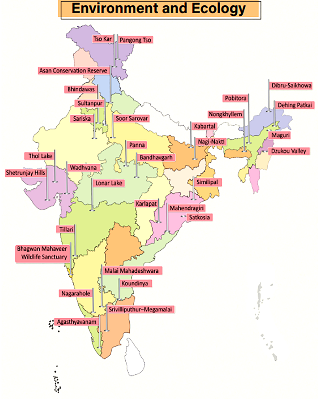
Agasthyavanam Biological Park
Context
A recent initiative titled ‘Vanika’ by the Kerala Forest and Wildlife Department has enabled the tribals living in the Agasthyavanam Biological Park to sell their agriculture and forest produce online.
Key Points
- Established in 1997, Agasthyavanam Biological Park is a wildlife sanctuary near Thiruvananthapuram, Kerala.
- The Park has been named after the mesmerizing Agasthyamalai Agasthyakoodam Peak that can be seen at a distance.
- The Park is contiguous to the Neyyar and Peppara Wildlife Sanctuaries. The park forms part of a larger protected area of Agasthyamalai Biosphere Reserve.
Bandhavgarh Tiger Reserve
Context
India’s first hot air balloon wildlife safari in a tiger reserve was launched recently in Bandhavgarh Tiger Reserve.
Key Points
- Bandhavgarh Tiger Reserve is located in the eastern Satpura hill range of Umaria and Katni districts of Madhya Pradesh. Reference to this protected area is also found in the Narad Panch Ratna and Shiva Samhita Puran.
- Bandhavgarh was declared a National Park in 1968 and a Tiger Reserve in 1993. It is spread over Vindhya hills in Madhya Pradesh where topography varies from steep ridges, undulating, forest to open meadows.
- Bandhavgarh National Park consists of mixed vegetation ranging from tall grasslands to thick Sal forest and so is the perfect habitat for a variety of animals and birds.
Bhagwan Mahaveer Wildlife Sanctuary
Context
Raising serious environmental concerns, the Central Empowerment Committee of the Supreme Court has red-flagged Goa rail projects cutting through Bhagwan Mahaveer Wildlife Sanctuary and the Mollem National Park.
Key Points
- Bhagwan Mahaveer Wildlife Sanctuary (BMWS), located on the foothills of the Western Ghats, is the largest of Goa’s four protected wildlife areas and contains within it the Mollem National Park (MNP).
- It is also home to the famous Dudhsagar waterfall and the Devil’s Canyon.
- Vegetation: West Coast tropical evergreen forests, West Coast semi-evergreen forests and moist deciduous forests.
- Fauna: Deer, sambar, spotted deer, hog, mouse deer and barking deer, tiger, leopard cat, panther, lesser Indian civet, wild dog, hyena, sloth bear, jackal, bonnet macaque, slender loris, scaly anteater, giant squirrel, flying squirrel etc.
- Flora: Primary species of trees found here include Terminalia, Lagerstroemia (crepe myrtle), Xylia and Dalbergia (timber trees).
Dehing Patkai Wildlife Sanctuary
Context
The Assam government has decided to upgrade Dehing Patkai Wildlife Sanctuary into a National Park.
About
- Post upgradation, Dehing Patkai will be the sixth National Park in Assam - the other five being Kaziranga, Nameri, Manas, Orang and Dibru-Saikhowa.
- Dehing Patkai was declared a Wildlife Sanctuary in 2004 and is home to a vast variety of flora and fauna.
- It is located within the larger Dehing Patkai Elephant Reserve, which spreads across the coal- and oil-rich districts of Upper Assam (Dibrugarh, Tinsukia and Sivasagar) and is believed to be the last remaining contiguous patch of lowland rainforest area in Assam.
- Fauna: Rare fauna found in the region include Chinese pangolin, flying fox, wild pig, sambar, barking deer, gaur, serow and Malayan giant squirrels.
- It is the only sanctuary in India that is home to seven different species of wild cats - tiger, leopard, clouded leopard, leopard cat, golden cat, jungle cat and marbled cat.
- It has the highest concentration of the endangered White Winged Wood Duck.
- Flora: Dehing Patkai is a deciduous rainforest interspersed with semi-evergreen and lush green flora.
Dibru-Saikhowa National Park
Context
The decision of Oil India Ltd. to drill seven wells inside the Dibru-Saikhowa National Park has raised concerns.
About
- Dibru-Saikhowa is a National Park as well as a Biosphere Reserve situated on the south bank of the river Brahmaputra in the extreme east of Assam.
- It is bounded by Lohit and Brahmaputra rivers on the north and the Dibru river on the southern side.
- Forests: Semi-evergreen forests, deciduous forests, littoral and swamp forests and patches of wet evergreen forests.
- The largest Salix swamp forest of North East India is located inside this reserve.
- Fauna: Tiger, Elephant, Leopard, Small Indian Civet, Gangetic Dolphin, Slow Loris, etc.
- It is identified as an Important Bird and Biodiversity Area.
Dzukou Valley
Context
A wildfire blazed the Dzukou Valley straddling the Manipur-Nagaland border.
About Dzukou Valley
- The Dzukou Valley is located at the border of Nagaland and Manipur. Located just behind the Japfu Peak, it is one of the most popular trekking spots in the North East.
- Dzukou valley and Japfu peak are located adjacent to the Pulie Badze Wildlife Sanctuary (Nagaland).
- Home to the Angami people, the valley is also famous for its wide range of flowers in every season.
- Fauna: It is home to Blyth's tragopan, which is the state bird of Nagaland. Asian golden cat, the Hoolock Gibbon, the Dzukou Valley horned toad, the capped langur, the stump-tailed macaque, and the serow.
- Flora: The valley is famous for its wide range of flowers in every season but the most famous one is the Dzukou Lily and it is found only in this valley, several rhododendron species, plants such as the Aconita nagaram.
Karlapat Wildlife Sanctuary
Context
Six elephants died of haemorrhagic septicaemia in Karlapat Wildlife Sanctuary, recently.
About Karlapat Wildlife Sanctuary
- The sanctuary is located in Kalahandi district, Odisha.
- Vegetation: Dry Deciduous Forest.
- Fauna: Leopard, gaur, sambar, nilgai, barking deer, mouse deer, soft claws ottawa, etc.
- Flora: Sal, Bija, Bamboo, medicinal plants, etc.
- Phurlijharan waterfall is located close to the sanctuary.
Koundinya Wildlife Sanctuary
Context
Herds of wild elephants from the forests abutting the Koundinya wildlife sanctuary and Tamil Nadu border often stray out much to the concern of the people and forest officials.
About Koundinya Wildlife Sanctuary
- Kaundinya is located in Palamner-Kuppam forest ranges of Chittoor district of Andhra Pradesh. The sanctuary is the only home for Asiatic elephants in the State of Andhra Pradesh.
- This Sanctuary comes under Project elephant - a country wide Elephant Conservation Project taken up by Government of India.
- The sanctuary has dry deciduous forests with thorny shrubs interspersed with trees.
- The sanctuary is situated in a region where the Kolar Plateau ends and slopes down into the plains of Tamil Nadu creating many valleys and ghats.
- Fauna: The vulnerable yellow-throated bulbul is found in the sanctuary.
- Some of the other animals found in the sanctuary are sloth bear, panther, cheetal, chowsingha, sambar, porcupine, wild boar, jungle cat, jackal, jungle fowl, starred tortoise and slender loris.
- Flora: Some of the important flora found include Albizia amara, Acacia, Lagerstroemia, Ficus, bamboo, and a species that is a regeneration of Santalum album.
Maguri Beel
Context
Recently, Mandarin ducks were sighted in the Maguri-Motapung beel after a century.
About Maguri beel
- Maguri (local term for walking catfish) Beel is a wetland and lake located near to Dibru-Saikhowa National Park in Tinsukia district in Assam.
- It is located on the south bank of the Dibru River and it connects the Dibru River through a small channel and finally meets the Brahmaputra river.
Mahendragiri Hill
Context
The Odisha government has proposed the state's second biosphere reserve in the southern part of Mahendragiri, a hill ecosystem having rich biodiversity.
About
- The area of the proposed Mahendragiri Biosphere Reserve is spread over Gajapati and Ganjam districts in the Eastern Ghats.
- When notified, it will become Odisha’s second biosphere reserve. The 5,569-square kilometre Similipal Biosphere Reserve is Odisha’s first such reserve and was notified May 20, 1996.
- Mahendragiri, with an elevation of 1,501 metres, is a hill in Odisha, situated along the Eastern Ghats. It is one of the highest points of Eastern Ghats.
- Mahendragiri is inhabited by the Soura people, a Particularly Vulnerable Tribal Group (PVTG).
Malai Mahadeshwara Hills Wildlife Sanctuary
Context
The Malai Mahadeshwara Hills Wildlife Sanctuary has been proposed to be declared as a Tiger Reserve. When notified, it will become Karnataka’s sixth Tiger Reserve.
About
- The proposed Tiger Reserve with a core area of about 670 km2 is spread across Malai Mahadeshwara Reserve Forest, Hanur Reserve Forest and Yediyarahalli Reserve Forest. The proposed Tiger Reserve is also part of the notified Mysore Elephant Reserve.
- The MM Hills WLS is contiguous to BRT (Biligiri Ranganathaswamy Temple) Tiger Reserve on one side and Sathyamangalam Tiger Reserve in Tamil Nadu on the other.
- The Cauvery Wildlife Sanctuary also borders it, thus providing a contiguous forest cover of over 3,500 km2 that can act as a sink to absorb surplus tiger population and help increase their numbers.
- There is an abundance of species like gaur, sambar, chital, four-horned antelope, wild boar, etc. The grizzled giant squirrel (IUCN Status: Near Threatened) is also found here. There are about 285 bird species documented in this landscape as per a 2014 survey.
Nagarahole National Park
Context
The Karnataka Forest Department plans to place a traffic monitoring mechanism for roads adjacent to Nagarhole National Park (NNP) to ensure better compliance of forest laws by motorists and minimise road kills.
About NNP
- NNP is also known as Rajiv Gandhi National Park. It is located in Kodagu and Mysore districts of Karnataka.
- Bandipur, Mudumalai and Wayanad Wildlife Sanctuaries are adjacent to NNP.
- Nagarahole river flows through the park and gradually joins the Kabini river which also is a boundary between Nagarahole and Bandipur.
- Fauna: Chital (spotted deer), Indian mouse deer, gaur, stripe-necked and ruddy mongooses, grey langur, bonnet macaque, Asian wild dog, leopard, tiger, etc.
Nagi-Nakti Bird Sanctuaries
Context
Recently, Bihar’s first state-level bird festival ‘Kalrav’ was organised at the Nagi-Nakti bird sanctuaries in the Jamui district.
About Nagi-Nakti Bird Sanctuaries
- The Nagi Dam and Nakti Dam are two sanctuaries so close to each other that they can be taken as one bird area.
- The Nagi-Nakti Bird Sanctuaries have been the home of a wide variety of indigenous species of birds and of migratory birds that turn up during the winters from places like Eurasia, Central Asia, the Arctic Circle, Russia and Northern China.
- Major avifauna found here include Indian Courser, Indian Sandgrouse, Yellow-wattled Lapwing and Indian Robin.
New Ramsar Sites in 2020
Context
In 2020, five sites were recognised as Wetlands of International Importance under the Ramsar Convention.
New Sites
- Asan Conservation Reserve
- The Asan Conservation Reserve is a man-made wetland situated near Herbatpur, a small town at the Uttarakhand-Himachal border in Dehradun.
- Kabartal Wetland
- Bihar has got Kabartal as its first Ramsar site in 2020. Also known as Kanwar Jheel, it is the largest ox bow lake comprising the floodplain of Burhi Gandak river.
- Lonar Lake
- Lonar lake, situated in the Deccan Plateau’s volcanic basalt rock, was created by the impact of a meteor 35,000 to 50,000 years ago.
- The lake is part of Lonar Wildlife Sanctuary which falls under the unified control of the Melghat Tiger Reserve (MTR).
- Soor Sarovar Lake
- It is also known as Keetham lake situated within the Soor Sarovar Bird Sanctuary, which was declared as a bird sanctuary in the year 1991.
- This lake is situated alongside the river Yamuna in Agra, Uttar Pradesh.
- Tso Kar Wetland
- Tso Kar is a high altitude wetland located 4,500 metres above sea level in the Changthang region of Ladakh.
- It’s a unique site where two lakes with contrasting chemical composition - freshwater Startsapuk Tso and the larger hyper saline Tso Kar - exist closely.
- It is called Tso Kar, meaning white lake, because of the white salt efflorescence found on the margins due to the evaporation of highly saline water.
New Ramsar Sites in 2021
Context
In August 2021, four more Indian sites - two each from Haryana and Gujarat - were recognised as Wetlands of International Importance under the Ramsar Convention. Thus, the total number of Ramsar Sites in India reached 46.
New sites
- Bhindawas Wildlife Sanctuary
- Located in Jhajjar, it is a human-made freshwater wetland. It is also the largest in Haryana. Over 250 bird species use the sanctuary throughout the year as a resting and roosting site.
- Sultanpur National Park
- It is one of the two National Parks in the state of Haryana. The other NP in Haryana is Kalesar National Park.
- Thol Lake Wildlife Sanctuary
- One of the most popular birding hotspots of Gujarat, the Thol Lake Wildlife Sanctuary is located near Ahmedabad..
- Wadhvana Wetland
- Located in Vadodara (Gujarat), Wadhvana Wetland is internationally important for its bird life as it provides wintering ground to migratory water birds, including over 80 species that migrate on the Central Asian Flyway.
Nongkhyllem Wildlife Sanctuary
Context
India’s first bamboo-dwelling bat (Eudiscopus denticulus) with sticky discs was recorded in Nongkhyllem Wildlife Sanctuary.
About
- This sanctuary, in Ri Bhoi district of Meghalaya, is one of the best protected areas in the Northeast. It falls in the Eastern Himalayan biodiversity hotspot.
- It is drained by rivers and streams like Umran, Umming, Umpurthih and Umtru. There is a natural lake named Birbah in the southern part of the Sanctuary.
- The sanctuary supports different species of fauna such as Royal Bengal Tiger, Clouded Leopard, Indian Bison, and Himalayan Black Bear, etc.
- Among the birds, the rare species which can be spotted here are Manipur Bush Quail, Rufous Necked Hornbill and Brown Hornbill.
- Other Protected Areas in Meghalaya include Siju Wildlife Sanctuary; Narpuh Wildlife Sanctuary; Baghmara Pitcher Plant Sanctuary; and Nokrek National Park.
Pangong Tso
Context
The lake in Ladakh was witness to the face-off between Indian and Chinese forces.
About Pangong Tso
- Pangong Lake, situated at a height of almost 4,350m, is the world’s highest saltwater lake.
- During summer, the Bar-headed goose and Brahmini ducks are commonly seen here.
- The region around the lake supports a number of species of wildlife including the kiang and the marmot.
- The lake hosts large quantities of fish, especially Schizopygopsis stoliczka and Racoma labiata.
- Extending to almost 160 km, one-third of the Pangong Lake lies in India and the other two-thirds in China.
- An Inner Line Permit is required to visit the lake as it lies on the Sino-Indian Line of Actual Control.
Panna Tiger Reserve
Context
Panna Tiger Reserve has been included in the World Network of Biosphere Reserves (WNBR) under Man and the Biosphere (MAB) Programme. India now has 12 out of 18 of its Biosphere Reserves listed in the MAB Programme.
About Panna Tiger Reserve
- Panna TR is located in the Vindhyas nearer to the confluence of the Deccan Peninsula, Upper Gangetic Plain and Semi-Arid Gujarat Rajputana reflecting the influence of three bio-geographic regions.
- Panna National Park was formed in 1981 and declared a Tiger Reserve in 1994. In 2011, Panna was designated as a Biosphere Reserve by the Union Ministry of Environment and Forests.
- This is the 12th biosphere reserve from India to be included in the World Network of Biosphere Reserves, and third from Madhya Pradesh, after Pachmarhi and Amarkantak.
- River Ken flows from the south to the north through the reserve.
- Fauna: Apart from the tiger, it is home to other animals like the leopard, nilgai, chinkara, chousingha, chital, rusty spotted cat, porcupine, and sambhar. Gharials (long snouted crocodiles) and muggars (marsh crocodiles) can be found in River Ken.
Pobitora Wildlife Sanctuary
Context
According to recent estimates, Pobitora has exceeded the carrying capacity and the Rhinos might need to be relocated to other areas in Assam.
About Pobitora Wildlife Sanctuary
- Pobitora Wildlife Sanctuary is situated on the southern bank of the Brahmaputra river in the district of Morigaon, Assam. Garanga Beel is located to the south of Pobitra.
- It is famous for its grasses that include Cynodon dactylon, whip grass (Hemarthria compressa), Vetiver (Chrysopogon zizanioides), Ravenna grass (Saccharum ravennae), Phragmites karka, etc.
- Pobitora WLS is also referred to as ‘Mini Kaziranga’ for similar features in terms of flora and fauna as well as some geographical features.
Sariska Tiger Reserve
Context
Sariska’s tiger population has risen to 21 with the birth of a new cub.
About Sariska Tiger Reserve
- It is a tiger reserve in Alwar district, Rajasthan comprising scrub-thorn arid forests, dry deciduous forests, grasslands, and rocky hills.
- It was given the status of a Tiger Reserve making it a part of India's Project Tiger in 1978.
- It is an important biodiversity area in the Northern Aravalli leopard and wildlife corridor.
- Fauna: Apart from the Bengal tiger, the reserve includes many wildlife species including Indian leopard, jungle cat, caracal, striped hyena, golden jackal, chital, sambar deer, small Indian civet, Javan mongoose, ruddy mongoose, honey badger, Rhesus macaque and Northern plains grey langur and Indian hare
- Flora: The dominant tree in the forests is dhok (Anogeissus pendula). Other trees include the salar (Boswellia serrata), kadaya (Sterculia urens), dhak (Butea monosperma), gol (Lannea coromandelica), ber (Ziziphus mauritiana), and khair (Acacia catechu).
Satkosia Tiger Reserve
Context
Recently, the National Tiger Conservation Authority has asked Odisha to submit a status report on the adverse impact of tourism on Satkosia Tiger Reserve.
About Satkosia Tiger Reserve
- Satkosia Tiger Reserve was designated in 2007 and comprises the Satkosia Gorge Wildlife Sanctuary and the adjacent Baisipalli Wildlife Sanctuary.
- It is located where the Mahanadi river passes through a 22 km long gorge in the Eastern Ghats.
- The tiger reserve is located in the Eastern Highlands moist deciduous forests ecoregion.
- Fauna: Leopard, Indian wild dog or dhole, wild boars, striped hyena, sloth bear, leopard cat, spotted deer, sambar deer, barking deer, langurs, porcupines and pangolins. The reptiles here include the Mugger Crocodile and gharials.
- Flora: The major plant communities are mixed deciduous forests including Sal (Shorea robusta), and riverine forest.
Shetrunjay Hills Reserve Forest
Context
A fire broke out in the Shetrunjay Hills reserve forest area of Gujarat.
About Shetrunjay Hills Forest
- The Shetrunjay Reserve Forest, a patch of hilly, dry and deciduous forest, is home to Asiatic lions and leopards as well as herbivores such as blue bulls.
- The Hills are located on the banks of river Shetrunji and are considered the sacred hill by Jains.
- The hills are bounded by the Gulf of Khambhat in the south and Bhavnagar town in the north.
- These hills were sanctified when Rishabhanath gave his first sermon atop the hill. Rishabhanath was the first Tirthankara of Jainism.
Similipal Biosphere Reserve
Context
A large tract of forest in the Similipal Biosphere Reserve was recently caught in fire.
About
- The Similipal Biosphere Reserve lies within two biogeographical regions: the Mahanadian east coastal region of the Oriental realm and the Chhotanagpur biotic province of the Deccan peninsular zone.
- It is surrounded by high plateaus and hills, the highest peak being the twin peaks of Khairiburu and Meghashini (1515m above mean sea level). Numerous waterfalls and perennial streams flow into major rivers, such as the Budhabalang, Baitarani and Subarnarekha.
- It was formally designated a Tiger Reserve in 1956 and was brought under Project Tiger in the year 1973.
- It was declared a Biosphere Reserve by the Government of India in June, 1994.
- It has been part of the UNESCO World Network of Biosphere Reserve since 2009.
- It is part of the Similipal-Kuldiha-Hadgarh Elephant Reserve popularly known as Mayurbhanj Elephant Reserve, which includes 3 protected areas i.e. Similipal Tiger Reserve, Hadagarh Wildlife sanctuary and Kuldiha wildlife sanctuary.
- Two tribes, the Erenga Kharias and the Mankirdias, inhabit the reserve’s forests and practice traditional agricultural activities (the collection of seeds and timber).
Srivilliputhur–Megamalai Tiger Reserve
Context
Recently, the Srivilliputhur–Megamalai Tiger Reserve in Tamil Nadu was approved. It is India’s 51st Tiger Reserve and fifth Tiger Reserve in Tamil Nadu.
About Srivilliputhur–Megamalai Tiger Reserve
- An area of 1,01,657.13 hectares or 1016.5713 km2 in Srivilliputhur Grizzled Giant Squirrel Sanctuary and Megamalai Wildlife Sanctuary have been combined to create the Tiger Reserve.
- Meghamalai Wildlife Sanctuary is spread across districts of Theni and Madurai (Highwavys mountains and Cardamom Hills) while Srivilliputhur Grizzled Squirrel Wildlife Sanctuary lies along Kerala’s Periyar Tiger Reserve.
- Fauna:
- Meghamalai hosts ungulates (hoofed mammals), spotted deers, Indian gaurs, wild boars, etc.
- Srivilliputhur hosts grizzled giant squirrels, flying squirrels, leopards, Nilgiri Tahrs, Sambars, elephants, lion-tailed macaques, etc.
- Other Tiger reserves in Tamil Nadu are Kalakkad Mundanthurai, Anamalai, Mudumalai and Sathyamangalam.
Tillari Conservation Reserve
Context
- The Maharashtra forest department declared the 29.53 km2 area of Dodamarg forest range in Sindhudurg district as ‘Tillari Conservation Reserve’.
About Tillari Conservation Reserve
- It is a 38-km-long Dodamarg wildlife corridor (earlier) that connects Radhanagari Wildlife Sanctuary in Maharashtra to Bhimgad Wildlife Sanctuary in Karnataka and frequently witnesses elephant and tiger movement.
- Tillari reserve has semi-evergreen forests and tropical moist deciduous forests.
International Relation
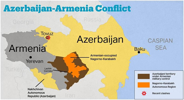
Armenia
Context
Recently, a territorial dispute between Armenia and Azerbaijan over the Nagorno-Karabakh region has re-erupted with heavy clashes.
About Armenia
- The capital is Yerevan.
- Armenia is the country of Transcaucasia. To the north and east, Armenia is bounded by Georgia and Azerbaijan, while its neighbours to the southeast and west, respectively, are Iran and Turkey.
- Most of the rivers fall into the drainage area of the Aras (itself a tributary of the Kura river of the Caspian basin), which forms a natural boundary between Armenia and Turkey and Iran.
- Armenia contains two terrestrial ecoregions: Caucasus mixed forests and Eastern Anatolian montane steppe.
- Azerbaijan falls along the International North-South Transport Corridor route, connecting India with Russia through central Asia.
Nagorno-Karabakh Conflict
- Nagorno-Karabakh is part of Azerbaijan, but its population is majority Armenian.
- As the Soviet Union saw increasing tensions in its constituent republics in the 1980s, Nagorno-Karabakh voted to become part of Armenia - sparking a war that stopped with a ceasefire in 1994.
- Since then, Nagorno-Karabakh has remained part of Azerbaijan but is controlled by separatist ethnic Armenians backed by the Armenian government.
- Armenia is majority Christian while Azerbaijan is majority Muslim. Turkey has close ties to Azerbaijan, while Russia is allied with Armenia - although it also has good relations with Azerbaijan.
NOTE: Transcaucasia, also known as the South Caucasus, is a geographical region on the border of Eastern Europe and Western Asia, straddling the southern Caucasus Mountains. Transcaucasia roughly corresponds to modern Georgia, Armenia, and Azerbaijan.
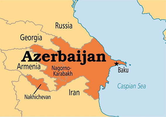
Azerbaijan
Context
The virtual Non-Aligned Movement meet of 2020 was hosted by the President of Azerbaijan.
About Azerbaijan
- The capital of Azerbaijan is the ancient city of Baku based on the Caspian Sea.
- Occupying an area that fringes the southern flanks of the Caucasus Mountains, it is bounded on the north by Russia, on the east by the Caspian Sea, on the south by Iran, on the west by Armenia, and on the northwest by Georgia.
- The highest peaks are Bazardyuzyu , Shakhdag, and Tufan - all part of the Greater Caucasus range.
- Major rivers are Kura (Source - Turkey) and Aras (Source - Turkey) and drain into the Caspian sea.
About Caspian Sea
- The Caspian Sea is the largest salt lake in the world. It is the world's largest inland body of water, variously classed as the world's largest lake or a full-fledged sea.
- It lies to the east of the Caucasus Mountains and to the west of the vast steppe of Central Asia. The sea’s name derives from the ancient Kaspi peoples, who once lived in Transcaucasia to the west.
- The sea is bordered in the northeast by Kazakhstan, in the southeast by Turkmenistan, in the south by Iran, in the southwest by Azerbaijan, and in the northwest by Russia.
- The major rivers - the Volga (Europe’s longest river), Ural, and Terek - empty into the northern Caspian Sea, along with the Sulak, Samur, Kura, and a number of smaller rivers.
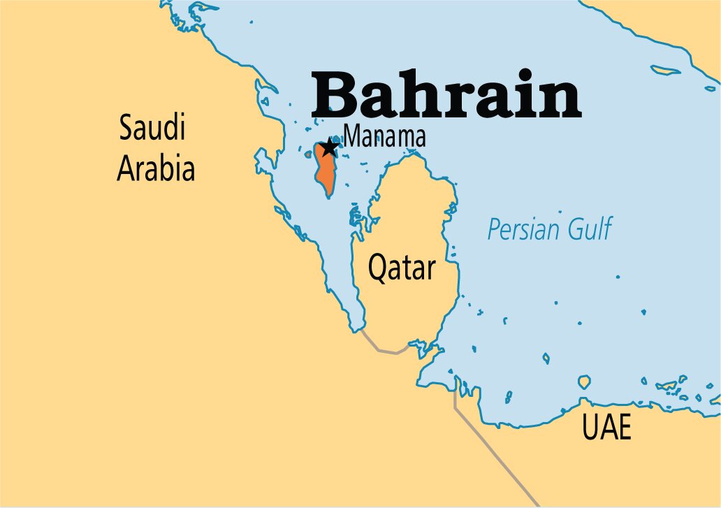
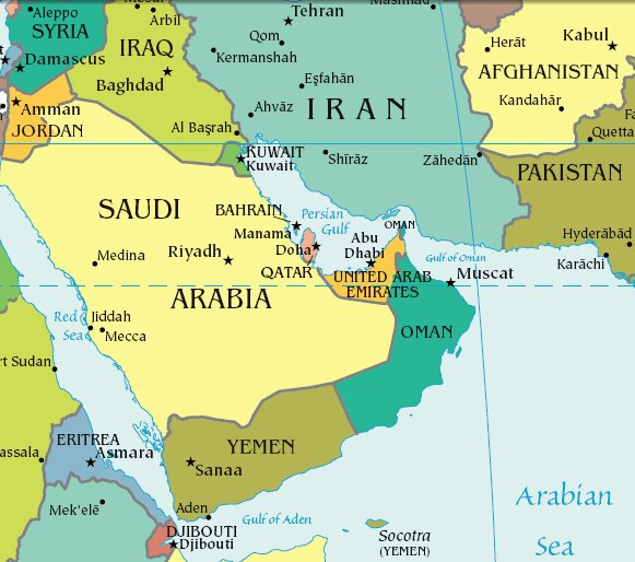
Bahrain
Context
The Abraham Accord was signed between Israel and Bahrain. It was mediated by the USA.
About Bahrain
- Bahrain is a small Arab state situated in a bay on the southwestern coast of the Persian Gulf.
- It is an archipelago consisting of Bahrain Island and some 30 smaller islands. Its name is from the Arabic term al-bahrayn, meaning “two seas”.
- The country’s chief city, port, and capital, Manama (Al-Manamah), is located on the northeastern tip of Bahrain Island.
- The country is situated between the Qatari peninsula and the northeastern coast of Saudi Arabia to which it is connected by the 25-kilometre King Fahd Causeway.
- Bahrain is the site of the ancient Dilmun civilization.
Abraham Accord
- In September 2020, the US mediated between Israel and the United Arab Emirates & Bahrain for the signing of the historic Abraham Accord, which is the first Arab-Israeli peace deal in 26 years.
- As per the agreements, the UAE and Bahrain will work together with Israel across a range of sectors, including tourism, trade, healthcare and security.
- Since Israeli independence in 1948, it has fought several wars with Arab neighbouring countries. While the persecuted Jews saw Israel as their promised home, the Arabs saw it as an occupation.
- Till the signing of the Abraham Accords, there were only two peace deals between Israel and the Arab States. Egypt was the first Arab State to sign a peace deal with Israel in 1979. Jordan signed a peace pact in 1994.
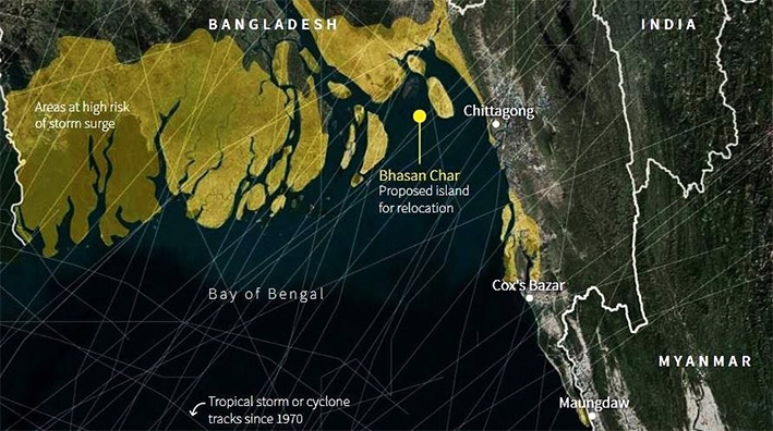
Bhashan Char Island
Context
The Rohingya refugees living in Bangladesh camps have been rehabilitated to Bhashan Char Island.
About Bhashan Char Island
- The island is also known as Char Piya and Thengar Char.
- It is located in the Bay of Bengal.
- The island was formed around 20 years ago at the estuary of the Meghna river with silt from the Ganga, Brahmaputra and Meghna. Much of the island rose above sea level as recently as 2006.
- Bangladesh wanted to move nearly 100,000 Rohingya refugees to the island to take the pressure off the overcrowded border camps.
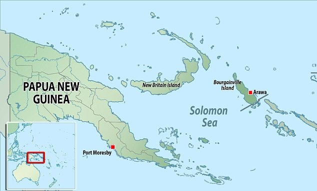
Bougainville Island
Context
The residents of the Bougainville Island sought a referendum to split from Papua New Guinea.
About
- Bougainville Island is the easternmost island of Papua New Guinea, in the Solomon Sea, southwestern Pacific. With Buka Island and several island groups, it forms the autonomous region of Bougainville.
- Geographically, Bougainville is the largest of the Solomon Islands, located near the northern end of that chain.
- Emperor Range, with its highest peak at Balbi and Bagana (both active volcanoes) occupies the northern half of the island, and the Crown Prince Range occupies the southern half.
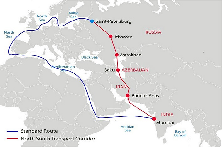
International North-South Transport Corridor
Context
The International North-South Transport Corridor (INSTC) connected Europe with India (mainly through territorial route) for the first time with a Finnish logistics company despatching a consignment from Finland to India.
About INSTC
- INSTC is a 7,200-km-long multi-mode network of ship, rail, and road routes. The route primarily involves moving freight from India, Iran, Azerbaijan and Russia.
- The major cities involved are Mumbai, Bandar Abbas, Tehran, Baku, Astrakhan, Moscow, etc.
- It is also in consonance with the Ashgabat agreement, a Multimodal transport agreement signed by India (2018 - year of joining), Oman (2011), Iran (2011), Turkmenistan (2011), Uzbekistan (2011) and Kazakhstan (2015).
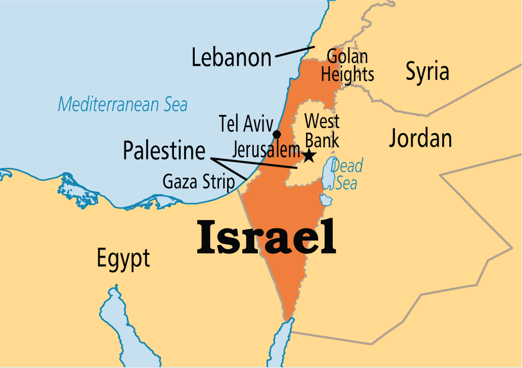
Israel
Context
The Israel-Palestine conflict witnessed a new rise.
About Israel
- Israel is a country in Western Asia, located on the southeastern shore of the Mediterranean Sea and the northern shore of the Red Sea.
- It has land borders with Lebanon to the north; Syria to the northeast; Jordan and the Palestinian territories of the West Bank to the east; the Palestinian territories of the Gaza Strip to the west; and Egypt to the southwest.
- The Jordan river marks part of the frontier between Israel and Jordan. The Jordan river runs along the Jordan Rift Valley, from Mount Hermon through the Hula Valley and the Sea of Galilee to the Dead Sea, the lowest point on the surface of the Earth.
Related Information
- Recently, a new human species was discovered in Nesher Ramla, Israel.
- The Nesher Ramla Homo group are an extinct population of archaic humans who lived during the Middle Pleistocene in modern-day Israel.
Kenya
Context
Scientists have discovered the oldest human burial (nearly 80,000-year-old grave) at Panga ya Saidi cave located in Kenya. The scientists have nicknamed the youngster ‘Mtoto,’ meaning ‘child’ in Swahili.
About Kenya
- Kenya, with capital Nairobi, is a country in Eastern Africa bisected horizontally by the Equator.
- Kenya is bordered by South Sudan to the northwest, Ethiopia to the north, Somalia to the east, Uganda to the west, Tanzania to the south, and the Indian Ocean to the southeast.
- Maasai, Luhya, Luo, Kalenjin, and Kikuyu are the important tribes living there.
- From the coast of the Indian Ocean, the low plains rise to central highlands. The highlands are bisected by the Great Rift Valley, with a fertile plateau lying to the east.
- The highlands are the site of the highest point in Kenya and the second-highest peak on the continent, Mount Kenya - which with a height of 5,199 m (17,057 ft) is a site of glaciers.
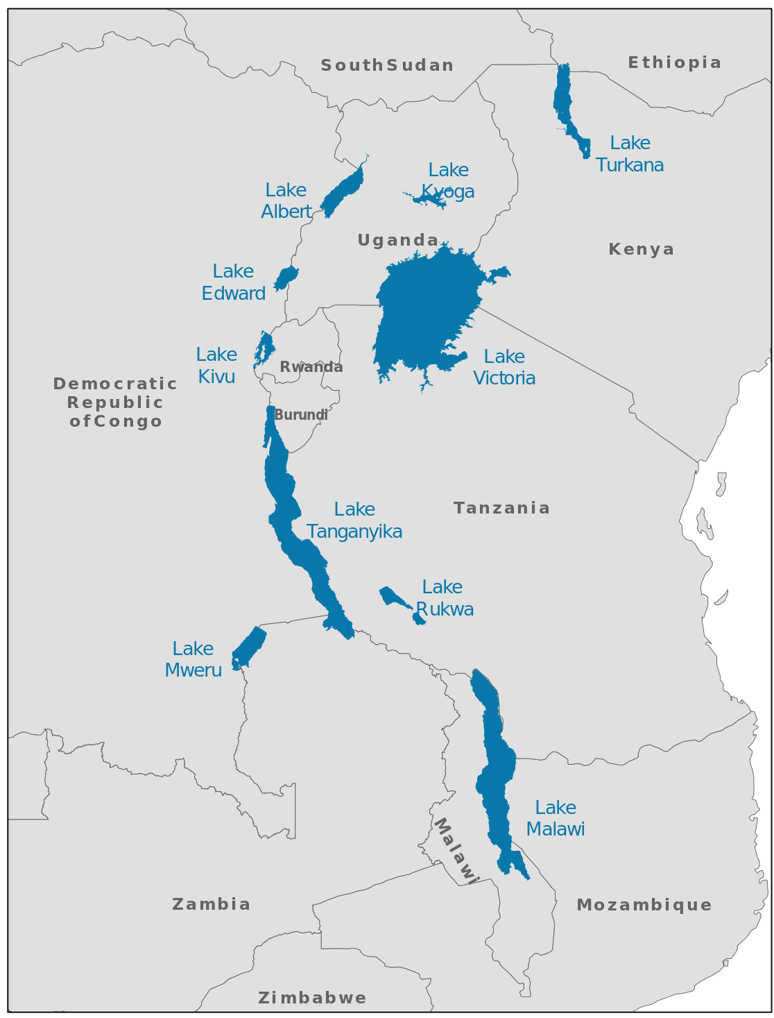
Kivu
Context
The Kivu region of Eastern Democratic Republic of the Congo (DRC) in Africa has been marred with an ethnic war over rights to natural resources.
About Kivu
- Kivu is a region of the DRC bordering the countries of Burundi, Rwanda, Tanzania, and Uganda.
- The Kivu region represents the high point of the East African Rift Valley.
- Lake Kivu is one of the great lakes of East Africa, situated between DRC to the west and Rwanda to the east.
About Democratic Republic of Congo
- Formerly known by the name of Zaire, it is a country in Central Africa. The country is cut across by the Equator.
- It is, by area, the largest country in sub-Saharan Africa and the second-largest in all of Africa (after Algeria).
- It is bordered
- to the north by the Central African Republic,
- to the northwest by the Republic of the Congo,
- to the northeast by South Sudan,
- to the east by Uganda, Rwanda and Burundi, and by Tanzania (across Lake Tanganyika),
- to the south and southeast by Zambia,
- to the southwest by Angola, and
- to the west by the South Atlantic Ocean and the Cabinda Province exclave of Angola.
- The area sustains the Congo Rainforest, the second-largest rainforest in the world after the Amazon.
- The capital, Kinshasa, is located on the Congo River.
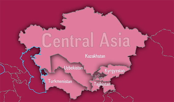
Kyrgyzstan
Context
Kyrgyzstan and Tajikistan recently engaged in border clashes.
Key points
- The fighting was because of the water facilities in territory claimed by both Kyrgyzstan and Tajikistan. The meandering boundary between the two countries is particularly tense as over a third of it is disputed. Restrictions on access to land and water that communities regard as theirs have often led to deadly clashes in the past.
- Kyrgyzstan and Tajikistan, both came into existence after the disintegration of the Union of Soviet Socialist Republics (USSR).
- Kyrgyzstan, with its capital Bishkek, is a landlocked country in Central Asia. It is bounded by Kazakhstan on the northwest and north, by China on the east and south, and by Tajikistan and Uzbekistan on the south and west.
- Tajikistan, with its capital Dushanbe, is also a landlocked country lying south of Kyrgyzstan. It is bordered by China on the east, Afghanistan on the south, and Uzbekistan on the west and northwest.
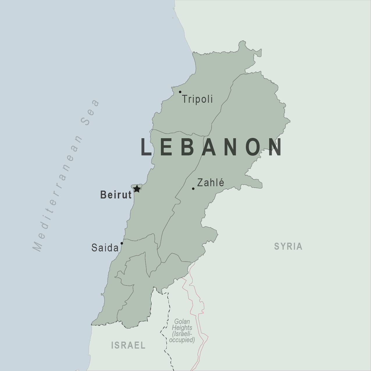
Lebanon
Context
On 4 August 2020, a large amount of ammonium nitrate stored at the port of the city of Beirut, the capital of Lebanon, exploded.
About Lebanon
- Beirut is the capital and largest city of Lebanon situated at the coast of Mediterranean sea.
- It is flanked by the Lebanon Mountains and has taken on a triangular shape, largely influenced by its situation between and atop two hills: Al-Ashrafieh and Al-Musaytibah.
- It is bordered by Syria to the north and east and Israel to the south, while Cyprus lies west across the Mediterranean Sea.
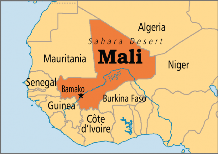
Mali
Context
In late May 2021, Mali’s military carried out a coup against its interim government.
About Mali
- Mali, with capital Bamako, is a landlocked country of western Africa, mostly in the Saharan and Sahelian region.
- Mali is bounded on the north by Algeria, on the east by Niger and Burkina Faso, on the south by Côte d’Ivoire and Guinea, and on the west by Senegal and Mauritania.
- The Niger River flows through its interior, functioning as the main trading and transport artery in the country.
- The Bambara (Bamana) ethnic group and language predominate, with several other groups - including the Fulani (Fulbe), Dogon, and Tuareg - present in the population.
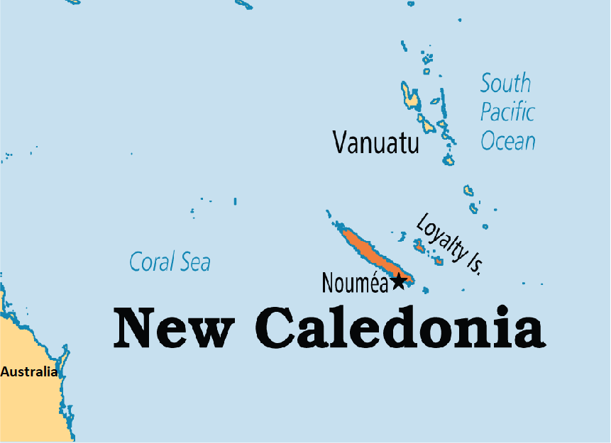
New Caledonia
Context
The French territory of New Caledonia voted against independence from France in a referendum held recently.
About New Caledonia
- New Caledonia is a special collectivity of France in the southwest Pacific Ocean, south of Vanuatu, east of Australia.
- New Caledonia is part of Zealandia, a fragment of the ancient Gondwana supercontinent.
- New Caledonia’s lagoons, with their diverse reefs and associated ecosystems, were designated a UNESCO World Heritage site in 2008.
- New Caledonia’s highest point is Mount Panie.
- The Diahot river is the longest river in the country.
- New Caledonia is home to the New Caledonian crow, a bird noted for its tool-making abilities, which rival those of primates.
- New Caledonia is a territory sui generis to which France has gradually transferred certain powers. As such its citizens have French nationality and vote for the President of France. They have the right to vote in elections to the European Parliament.
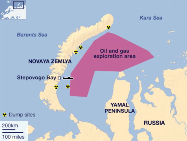
Novaya Zemlya
Context
Russia tested the world's most powerful hydrogen bomb in Novaya Zemlya.
About Novaya Zemlya
- Novaya Zemlya is an archipelago of Russia. It is situated in the Arctic Ocean, in the extreme northeast of Europe.
- It houses the easternmost point of Europe lying at Cape Flissingsky.
- To Novaya Zemlya's west lies the Barents Sea, and to the east is the Kara Sea.
- Novaya Zemlya is composed of two main islands, the northern Severny Island and the southern Yuzhny Island, which are separated by the Matochkin Strait.
Persian Gulf
Context
India has been maintaining a fleet of warships in the Persian Gulf to aid its merchant ships.
About Persian Gulf
- It is a shallow marginal sea of the Indian Ocean that lies between the Arabian Peninsula and southwestern Iran.
- It is bordered
- on the north, northeast, and east by Iran;
- on the southeast and south by part of Oman and by the United Arab Emirates;
- on the southwest and west by Qatar, Bahrain, and Saudi Arabia; and
- on the northwest by Kuwait and Iraq.
- In the northwest, immense quantities of silt are deposited by the Tigris, Euphrates, and Karun rivers.
- Safaniya Oil Field, the world's largest offshore oilfield, is located in the Persian Gulf.
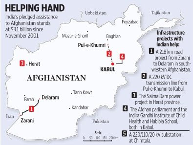
Shahtoot Dam
Context
India and Afghanistan have signed an agreement to build the Shahtoot Dam in Kabul to provide drinking water in the Afghanistan capital.
Key points
- Earlier India has built Salma Dam (India-Afghanistan Friendship Dam) on the Hari river in Afghanistan.
- Afghanistan, with capital Kabul, is a mountainous landlocked country at the crossroads of Central and South Asia.
- Afghanistan is bordered by Pakistan to the east and south; India to the south east (through the Pakistan Occupied Kashmir); Iran to the west; Turkmenistan, Uzbekistan, and Tajikistan to the north; and China to the northeast.
- Afghanistan shares its longest land border (the Durand Line) with Pakistan to the east and south.
- Major rivers of Afghanistan include Kabul, Amu Darya, Harirud, and Helmand.
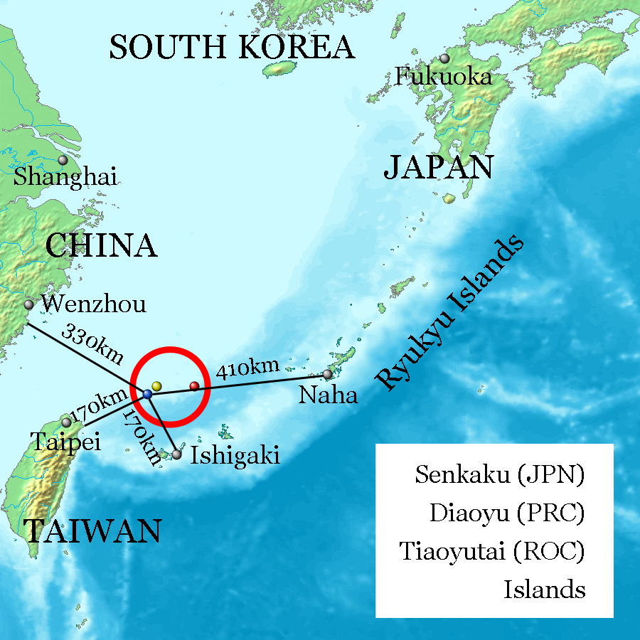
Senkaku Islands
Context
Recently, a local council in southern Japan approved a bill to change the name of an area containing Senkaku Islands from Tonoshiro to Tonoshiro Senkaku.
About Senkaku Islands
- These are a group of uninhabited islands in the East China Sea and are disputed territory between China, Taiwan and Japan.
- These are located east of China, northeast of the Republic of China, west of Okinawa Island, and north of the southwestern end of the Ryukyu Islands.
Sinai Peninsula
Context
The Egyptian Army recently launched raids and air attacks targeting terrorist hideouts in Bir al-Abed, Rafah and Sheikh Zuweid, in the Sinai peninsula area.
About Sinai Peninsula
- The Sinai Peninsula is a peninsula in Egypt and is the only part of the country located in Asia. Egypt is majorly located in Africa.
- Sinai is located between the Mediterranean Sea to the north and the Red Sea to the south and is a land bridge between Asia and Africa.
- The Sinai Desert, as the peninsula’s arid expanse is called, is separated by the Gulf of Suez and the Suez Canal from the Eastern Desert of Egypt, but it continues eastward into the Negev desert without marked change of relief.
- It is linked to the African continent by the Isthmus of Suez.

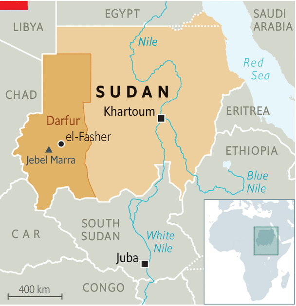
Sudan
Context
A war has been going on in the Darfur region of Sudan.
About Darfur
- The war began in February 2003 when the Sudan Liberation Movement (SLM) and the Justice and Equality Movement (JEM) rebel groups began fighting the government of Sudan, which they accused of oppressing Darfur's non-Arab population.
- Darfur is largely a semi-arid plateau with the Marrah Mountains (Jebel Marra), a range of volcanic peaks rising up to 3,042 meters (9,980 ft) of topographic prominence.
- The region's main towns are Al Fashir, Geneina, and Nyala.
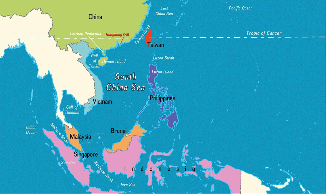
Taiwan Strait
Context
A U.S. warship sailed through the Taiwan Strait in what the American military described as a routine passage, but enraging China, which claims sovereignty over the island and surrounding seas.
About Taiwan Strait
- The Taiwan Strait is a 180-kilometer wide strait separating the island of Taiwan and continental Asia (China to be specific).
- The strait is part of the South China Sea and connects to the East China Sea to the north.
- Former names of the Taiwan Strait include the Formosa Strait or Strait of Formosa.
Tsari Chu River
Context
Satellite image shows that China has built a new village in the disputed region of Arunachal Pradesh on the banks of Tsari Chu river. It merges with the Subansiri river at Gelensiniak in the Upper Subansiri district of Arunachal Pradesh.
Key Points
- There are close to two dozen spots along the entire length of the Line of Actual Control (LAC) in all sectors where India and China do not agree on its alignment.
- Line of Actual Control is divided into three sectors:
- The eastern sector which spans Arunachal Pradesh and Sikkim (1346 km).
- The middle sector in Uttarakhand and Himachal Pradesh (545 km).
- The western sector in Ladakh (1597 km).
- The alignment of the LAC in the eastern sector is along the 1914 McMahon Line.
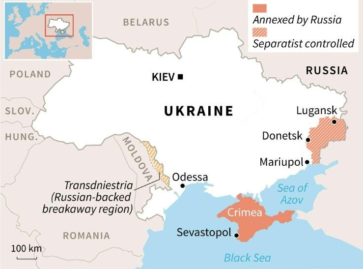
Ukraine
In news
Recently, tension erupted between Russia and England as the latter sailed its warship near the coast of Crimea, a peninsula in Black Sea that was until 2014 formed part of Ukraine.
About Ukraine
- Ukraine is located in eastern Europe. The capital city Kyiv (Kiev) is situated on the Dnieper river in north-central Ukraine.
- Ukraine is bordered by Belarus to the north, Russia to the east, the Sea of Azov and the Black Sea to the south, Moldova and Romania to the southwest, and Hungary, Slovakia, and Poland to the west.
- In the far southeast, Ukraine is separated from Russia by the Kerch Strait, which connects the Sea of Azov to the Black Sea.
- Ukraine has a mostly temperate climate, with the exception of the southern coast of Crimea which has a subtropical climate.
- The shores of the Black Sea and the Sea of Azov are characterized by narrow, sandy spits of land that jut out into the water; one of these, the Arabat Spit, 113 km long.
- Ukraine’s Maidan Revolution ended in late February 2014, when the then President Victor Yanukovych fled to Russia. The Rada (Ukraine’s parliament) appointed an acting president and acting prime minister. They made clear their intention to draw Ukraine close to the European Union.
- In a referendum held later in 2014, the majority of Crimeans voted for integration of Crimea with Russia. Since then, Russia has been exercising its jurisdiction over Crimea, though the European powers and the US contest the legality of the referendum.
MAP
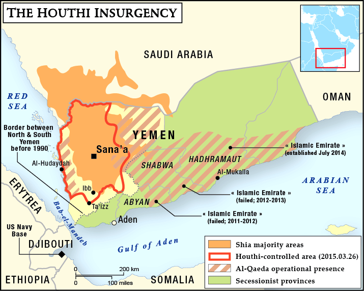
Yemen
Context
The civil war that began in late 2014 in Yemen has entered its seventh year. It is mainly fought between the Abdrabbuh Mansur Hadi-led Yemeni government and the Houthi rebels.
About Yemen
- Yemen is situated at the southwestern corner of the Arabian Peninsula.
- It borders Saudi Arabia to the north and Oman to the northeast and shares maritime borders with Eritrea, Djibouti, and Somalia.
- Yemen's constitutionally stated capital, and largest city, is the city of Sanaa, but the city has been under Houthi rebel control. Thus, its executive administration resides in Riyadh, Saudi Arabia.
- Yemen is a member of the Arab League, the United Nations, the Non-Aligned Movement and the Organisation of Islamic Cooperation.
- A number of Red Sea islands, including the Hanish Islands, Kamaran, and Perim, as well as Socotra in the Arabian Sea, belong to Yemen. The largest of these is Socotra.
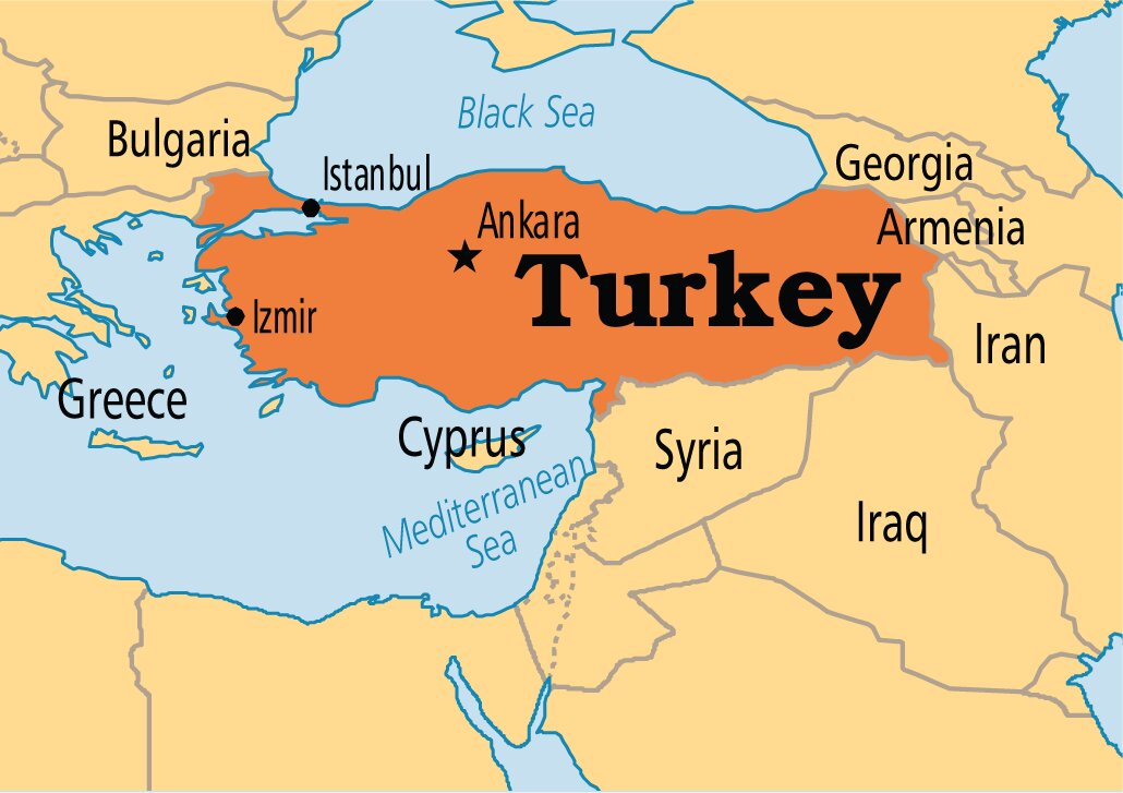
Turkey
Context
Turkish President Recep Tayyip Erdoğan signed a presidential decree turning the Hagia Sophia back into a mosque and opening it as a place of prayer and worship.
About Turkey
- Turkey, with capital Istanbul, is a country straddling Western Asia and Southeast Europe.
- It shares borders with
- Greece and Bulgaria to the northwest;
- Black Sea to the north;
- Georgia to the northeast;
- Armenia, Azerbaijan, and Iran to the east;
- Iraq to the southeast;
- Syria and the Mediterranean Sea to the south; and
- the Aegean Sea to the west.
- Asian Turkey, which includes 97% of the country's territory, is separated from European Turkey by the Bosporus, the Sea of Marmara, and the Dardanelles.
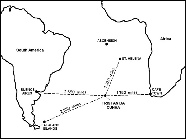
Tristan da Cunha
Context
The isolated UK Overseas Territory of Tristan da Cunha was declared as the largest fully protected marine reserve in the Atlantic Ocean at 687,000 km2.
About Tristan da Cunha
- This archipelago lies approximately 2,432 km off the coast of Cape Town in South Africa.
- It is home to the world’s most remote human settlement. It is the fourth largest completely protected marine area in the world and the largest in the Atlantic.
- Tristan da Cunha is a British Overseas Territory with its own constitution.
- As of October 2018, the main island has 250 permanent inhabitants, who all carry British Overseas Territories citizenship.
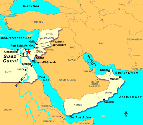
Suez Canal
Context
Traffic resumed in Egypt's Suez Canal after a stranded container ship had blocked it for nearly a week.
About Suez canal
- Suez Canal (built during 1859 & 1869) is a sea-level waterway running north-south across the Isthmus of Suez in Egypt to connect the Mediterranean and the Red seas.
- Topographically, the Isthmus of Suez is not uniform. There are three shallow water-filled depressions: Lake Manzala, Lake Timsah, and the Bitter Lakes.
- The Suez Canal separates the African continent from Asia, and it provides the shortest maritime route between Europe and the lands lying around the Indian and western Pacific oceans.
- The canal extends 193 km between Port Said in the north and Suez in the south. To the west of the canal is the low-lying delta of the Nile River, and to the east is the higher, rugged, and arid Sinai Peninsula.
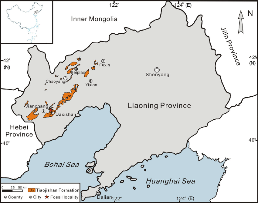
Tiaojishan Formation of Liaoning, China
Context
A new pterosaur fossil was discovered at this location.
About Tiaojishan Formation
- The new pterosaur fossil was discovered in the Tiaojishan Formation of Liaoning, China, and is thought to be 160 million years old.
- It has been named Kunpengopterus antipollicatus, also dubbed “Monkeydactyl”. Geographically, the Tiaojishan Formation is widely distributed in western Liaoning Province and the neighbouring northern Hebei Province (China).
- This formation is lithologically composed of intermediate lava and pyroclastic rocks, interlayered with basic volcanic rocks and sedimentary deposits.
- It contains abundant and well-preserved fossil plants, including leaves, seeds and fruits, permineralized rhizomes and wood.
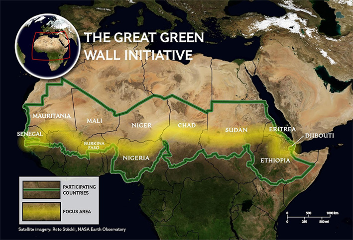
Sahel Region
Context
The Great Green Wall is taking roots in Africa's Sahel region, at the southern edge of the Sahara desert - one of the poorest places on the planet.
About Sahel
- Sahel is a semi-arid region of western and north-central Africa forming a transitional zone between the arid Sahara (desert) to the north and the belt of humid savannas to the south.
- The Sahel stretches from the Atlantic Ocean eastward through northern Senegal, southern Mauritania, the great bend of the Niger River in Mali, Burkina Faso, southern Niger, northeastern Nigeria, south-central Chad, and into Sudan.
- The Sahel has a tropical semi-arid climate (Köppen climate classification BSh).
- Protected areas in the Sahel include the Ferlo Nord Wildlife Reserve in Senegal, Sylvo-Pastoral and Partial Faunal Reserve of the Sahel in Burkina Faso, etc.
NOTE: The Great Green Wall is a symbol of hope in the face of one of the biggest challenges of our time – desertification. Launched in 2007 by the African Union, this game-changing African-led initiative aims to restore Africa’s degraded landscapes and transform millions of lives in one of the world’s poorest regions, the Sahel.
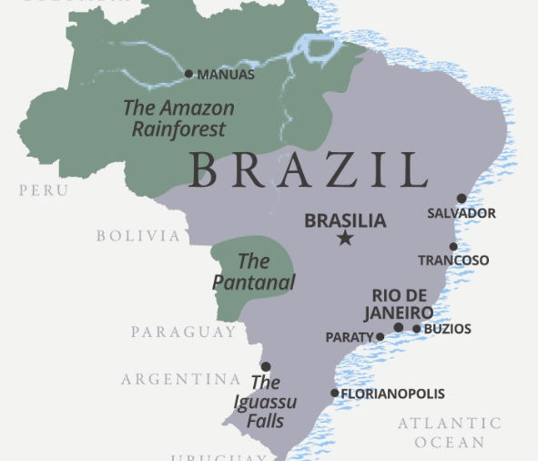
Pantanal
Context
The number of forest fires in the Pantanal has tripled in 2020.
About Pantanal
- Pantanal is the world’s largest tropical wetland, sprawled across Brazil, Bolivia and Paraguay.
- It is a gently-sloped basin that receives runoff from the upland areas (the Planalto highlands) and slowly releases the water through the Paraguay River and tributaries.
- The vegetation of the Pantanal, often referred to as the "Pantanal complex", is a mixture of plant communities typical of a variety of surrounding biome regions. These include:
- moist tropical Amazonian rainforest plants,
- semi-arid woodland plants typical of northeast Brazil,
- Brazilian cerrado savanna plants and
- plants of the Chaco savannas of Bolivia and Paraguay.
- Among the many other benefits that the region offers is its function as a huge area for water purification and for groundwater discharge and recharge and as a source of water.
- In 2000, the Pantanal Conservation Complex - a cluster of four protected areas at the southwest corner of the state of Mato Grosso - was inscribed as a protected UNESCO World Heritage natural site.
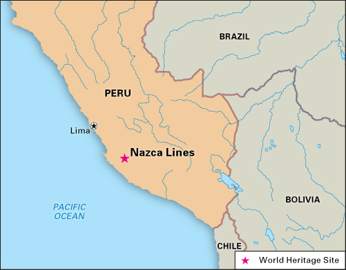
Nazca Lines, Peru
Context
Recently, a giant cat geoglyph was discovered on a hill at the famous Nazca Lines site in Peru.
About Nazca Lines
- Nazca Lines are groups of geoglyphs i.e. the large line drawings that appear, from a distance, to be etched into the Earth’s surface. These are located on the arid Pampa Colorada, northwest of the city of Nazca in southern Peru.
- Most of the Nazca Lines were constructed more than 2,000 years ago by the people of the Nazca culture (200 BCE–600 CE), though some clearly predate the Nazca and are considered to be the work of the earlier Paracas culture.
- While the images dated to the Paracas are often humanlike and bear some resemblance to still-earlier petroglyphs in the region, the subjects of the Nazca-made lines are generally plants and animals - such as a monkey, a killer whale, a spider, and various flowers, trees, and other plants as well as geometric shapes like triangles and spirals.
- They were designated in 1994 as a UNESCO World Heritage Site.
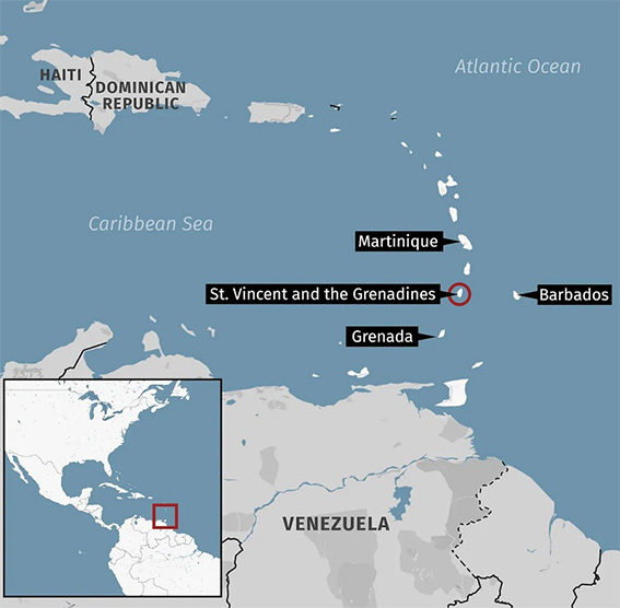
La Soufriere Volcano
Context
The Sulphur Dioxide (SO2) emissions from a volcanic eruption in the Caribbean (La Soufriere Volcano) have reached India, sparking fear of increased pollution levels in the northern parts of the country.
About
- La Soufriere Volcano is an active stratovolcano on the Caribbean island of Saint Vincent in Saint Vincent and the Grenadines.
- Saint Vincent and the Grenadines, located in the southern Caribbean, consists of more than 30 islands and cays, nine of which are inhabited.
- La Soufriere is the highest peak in Saint Vincent and has had five recorded explosive eruptions since 1718, most recently in April 2021.
NOTE: A stratovolcano is a tall, conical volcano composed of one layer of hardened lava, tephra, and volcanic ash. These volcanoes are characterized by a steep profile and periodic, explosive eruptions.
Larsemann Hills
Context
A plant species named Bryum bharatiensis has been discovered by India based scientists in the Larsemann Hills of Antarctica. This is located near Bharati, India’s research station in Antarctica.
About Larsemann Hills
- The Larsemann Hills are a series of low rounded coastal hills along the southeastern shore of Prydz Bay, Antarctica extending for 9 nautical miles (17 km) from Dalk Glacier.
- As an Antarctic oasis, the hills are the home of several Antarctic research stations.
- The abandoned Russian Progress Station.
- The relocated Russian Progress II Station.
- The Chinese Zhongshan station
- The Australian-donated Romanian Law-Racovita Station
- The Indian research station Bharati
- Major geographical features of Antarctica include:
- Vinson Massif (tallest in the region)
- Mount Erebus
- Mount Stephenson
- Vestfold Hills
- McMurdo Dry Valleys
- Bunger Hills
About Bryum bharatiensis
- Plants need nitrogen, along with potassium, phosphorus, sunlight and water to survive. Only 1% of Antarctica is ice-free that could make it difficult for the plant to find a habitable niche.
- The scientists found that Bryum bharatiensis is a moss that mainly grows in areas where penguins breed in large numbers. Penguin poop has nitrogen.
- These plants survive under thick snow during the six winter months with no sunlight and temperatures dropping to as low as -76℃.
- Scientists say it is likely that the moss "dries up to a dormant stage, almost to a seed" at this time, and germinates again during summer in September when they begin getting sunlight again. The dried up moss then absorbs water from the melting snow.
- More than 100 species of moss have been documented from Antartica.
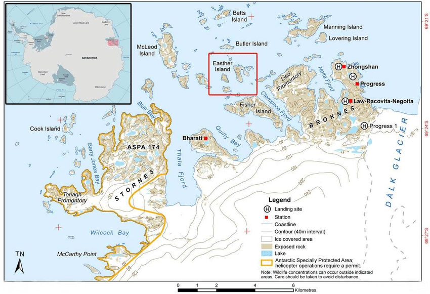
Leang Tedongnge Cave
About Leang Tedongnge Cave
- Archaeologists have discovered the world’s oldest known cave art in Leang Tedongnge cave in Indonesia.
- The cave is in a valley that is enclosed by steep limestone cliffs, and is only accessible by a narrow cave passage in the dry season, as the valley floor is completely flooded in the wet season.
- The cave painting uncovered in South Sulawesi consists of a figurative depiction of a warty pig, a wild boar that is endemic to this Indonesian island.
Lake Baikal
Context
Russian scientists recently launched one of the world’s biggest underwater neutrino telescopes called the Baikal-GVD (Gigaton Volume Detector) in the waters of Lake Baikal.
About Lake Baikal
- Lake Baikal is a rift lake located in southern Siberia, Russia. It is the world’s deepest lake.
- It is the oldest existing freshwater lake on Earth (20 million–25 million years old), as well as the deepest continental body of water, having a maximum depth of 5,315 feet (1,620 metres).
- It is also the world’s largest freshwater lake by volume, containing about one-fifth of the freshwater on Earth’s surface.
- Into Lake Baikal flows more than 330 rivers and streams, the largest of which include the Selenga, Barguzin, Upper (Verkhnyaya) Angara, Chikoy, and Uda.
- The only outflow is through the Angara River, a tributary of the Yenisey.
NOTE: Baikal GVD is one of the three largest neutrino detectors in the world along with the IceCube at the South Pole and ANTARES in the Mediterranean Sea.
Lake Chad
Context
One of Africa’s largest freshwater bodies, Lake Chad, has shrunk by 90%.
About Lake Chad
- This freshwater lake is located in the Sahelian zone of West-central Africa.
- It is surrounded by four countries - Chad, Cameroon, Niger, and Nigeria.
- It is the largest lake in the Chad Basin. Chad Basin is a vast depression in Central Africa that constitutes the largest inland drainage area on the continent of which Lake Chad forms a part.
- The Chari River, fed by its tributary the Logone, provides over 90% of the lake's water, with a small amount coming from the Yobe River in Nigeria/Niger.
- A 2001 study published in the Journal of Geophysical Research blamed the lake's retreat largely on overgrazing in the area surrounding the lake, causing desertification and a decline in vegetation.
- The United Nations Environment Programme and the Lake Chad Basin Commission concur that at least half of the lake's decrease is attributable to shifting climate patterns.
About Semeru volcano
- Recently, Semeru volcano erupted in Indonesia’s East Java province. Semeru - also known as “The Great Mountain” - is the highest volcano in Java and one of the most active.
- Indonesia, with the maximum number of active volcanoes in the world, is prone to seismic upheaval due to its location on the Pacific’s Ring of Fire.
- Semeru volcano is also part of the Island arcs formed by the subduction of the Indo-Australian plate below the Sunda Plate (part of Eurasian Plate). The trench formed here is called Sunda trench whose major section is the Java Trench.
NOTE: The Ring of Fire, also referred to as the Circum-Pacific Belt, is a path along the Pacific Ocean characterized by active volcanoes and frequent earthquakes. Its length is approximately 40,000 kilometers. 75% of Earth's volcanoes - more than 450 volcanoes - are located along the Ring of Fire.
Important Schemes and Programmes
Brief Description
- India recently celebrated its 75th Independence Day on August 15, 2021.
- ‘Nation First, Always First’ is the theme of India’s 75th Independence Day celebrations.
- The Prime Minister of India while addressing the nation mentioned various schemes and programmes to highlight the efforts taken by the government in recent times.
- We have tried to compile various key points of the PM Independence day address. A quick revision will help the aspirants to solve the question in UPSC CSE-2021 Preliminary Examination.
World's Largest Vaccination Program
- India began the "World's Largest Vaccination Program" on January 16, 2021 in the fight against COVID-19, with the approval of two made-in-India COVID-19 vaccines; Covishield and Covaxin.
- Covaxin is an inactivated vaccine whereas Covishield is a live vaccine.
- The government has launched the Co-WIN application for the registration of the citizens and to generate digital certificates of vaccination.
Co-WIN and Digital Certificates
- Co-WIN is a cloud-based IT platform which handles the minute details for India’s Covid-19 immunisation programme, including registering beneficiaries, allocating vaccination centres, sending text messages with the name of their vaccinator to beneficiaries and live monitoring of vials in cold storage.
- The platform is owned by the Ministry of Health and Family Welfare (MoHWA).
- MeitY along with the National Informatics Centre are responsible for handling the tech infrastructure of the app.
Amrit Kaal
- In his 75th Independence day speech, the Prime Minister of India referred to the period of next 25 years as the Amrit Kaal for India and her citizens.
- The purpose of Amrit Kaal is:
- To better the lives of citizens
- Lessen the development divide between villages and city
- Reduce government interference in people's lives and
- Have the latest technology so that India is not behind any country in the world.
- India started with the spirit of ‘SabkaSaath, Sabka Vikas, Sabka Vishwas’ and now SabkaPrayas (collaborative effort of all) is added as a very important aspect for the achievement of India’s goals for development.
Ujjwala 2.0
- Recently, the second phase of Pradhan Mantri Ujjwala Yojana (PMUY) or Ujjwala 2.0 Scheme was launched.
- PMUY-I was launched in May 2016 to provide LPG connections to poor households.
- It is being implemented by the Ministry of Petroleum and Natural Gas.
- It is aimed to provide maximum benefit to the migrants who live in other states and find it difficult to submit address proof.
- A financial support of Rs 1600 for each LPG connection will be provided to the BPL households.
- An additional 10 million LPG connections will be provided to the beneficiaries.
Ayushman Bharat Pradhan Mantri Jan Arogya Yojana (AB PM-JAY)
- AB PM-JAY offers a sum insured of Rs.5 lakh per family for secondary as well as tertiary care.
- The Health Benefit Packages cover surgery, medical and day care treatments, cost of medicines and diagnostics.
- The beneficiaries are identified by latest Socio-Economic Caste Census (SECC) data.
- The National Health Authority (NHA) is the nodal agency for the implementation of PM-JAY.
- Funding:
- 60:40 for all states and UTs with their own legislature
- 90:10 in Northeast states and Jammu and Kashmir, Himachal and Uttarakhand
- 100% Central funding for UTs without legislature.
Pradhan Mantri Bhartiya Janaushadhi Pariyojana (PMBJP)
- PMBJP was launched by the Department of Pharmaceuticals in 2008 under the name Jan Aushadhi Campaign.
- The campaign was revamped as PMBJP in 2015-16.
- Bureau of Pharma PSUs of India (BPPI) (Ministry of Chemicals & Fertilizers) is the implementation agency for PMBJP.
- BPPI has also developed the Janaushadhi Sugam Application.
- Jan Aushadhi Kendras: The BPPI also supports Janaushadhi Kendras as a part of PMBJP where quality generic medicines are made available to all.
- The Kendras can be set up by doctors, pharmacists, entrepreneurs, Self Help Groups, NGOs etc. at any suitable place or outside the hospital premises.
PM SVANidhi
- The Ministry of Housing and Urban Affairs (MoHUA) launched PM SVANidhi, for providing affordable loans to street vendors.
- It was announced as a part of the Economic Stimulus-II under the Atmanirbhar Bharat Abhiyan.
- The vendors can avail a collateral-free, working capital loan of up to Rs. 10,000, which is repayable in monthly instalments within a year.
- There is no penalty on early repayment of loan.
- Microfinance Institutions, Non-Banking Financial Company, Self Help Groups are the lending institutions under the scheme.
- It is for the first time that these institutions have been allowed in a scheme for the urban poor due to their ground level presence and proximity to them.
Jal Jeevan Mission
- The mission envisages supply of 55 litres of water per person per day to every rural household through Functional Household Tap Connections (FHTCs) by 2024.
- The Jal Shakti Ministry is the nodal ministry for the implementation of the scheme.
- The fund sharing pattern between the Centre and states is 90:10 for Himalayan and North-Eastern States, 50:50 for other states, and 100% for Union Territories.
- In 2020, Goa became the first 'Har Ghar Jal' State in the country by successfully providing 100% FHTCs in the rural areas.
Malnutrition
- It refers to deficiencies, excesses or imbalances in a person’s intake of energy and/or nutrients. It addresses 3 broad groups of conditions:
- Undernutrition: includes wasting (low weight-for-height), stunting (low height-for-age) and underweight (low weight-for-age).
- Micronutrient-related malnutrition: micronutrient (important vitamins and minerals) deficiencies or excess.
- Overweight: obesity and diet-related non-communicable diseases (such as heart disease, stroke, diabetes and some cancers).
- Severe Acute Malnutrition (SAM): The World Health Organisation (WHO) defines severe acute malnutrition (SAM) by very low weight-for-height or a mid-upper arm circumference less than 115 mm, or by the presence of nutritional oedema.
Delimitation Commission in Jammu and Kashmir
- Delimitation is the act of fixing or redrawing the limits or boundaries of territorial constituencies (Assembly or Lok Sabha seat) in a country or a province having a legislative body.
- It is carried out by an independent high-powered panel known as the Delimitation Commission whose orders cannot be questioned by any court.
- It is appointed by the President of India and works in collaboration with the Election Commission of India.
- Under Article 82 of the Indian Constitution, the Parliament enacts a Delimitation Act after every Census.
- Under Article 170, States also get divided into territorial constituencies as per Delimitation Act after every Census.
Blue Economy
- The Blue Economy encourages better stewardship of the ocean or ‘blue’ resources.
- The concept was introduced by Gunter Pauli in 2010.
- It is the sustainable use of ocean resources for economic growth, improved livelihoods and ocean ecosystem health.
- Blue economy covers three economic forms:
- Economy coping with global water crisis
- Innovative development economy
- Development of marine economy
- India’s Initiatives for Blue Economy:
- Sagarmala Project
- O-SMART
- Integrated Coastal Zone Management Plan
- National Fisheries Policy for promoting 'Blue Growth Initiative'
Deep Ocean Mission
- In June 2021, the proposal of the Deep Ocean Mission was approved by the Cabinet Committee on Economic Affairs.
- The Ministry of Earth Sciences is the nodal ministry implementing the mission.
- It will be a mission mode project to support the Blue Economy Initiatives of the Government of India.
- India will become the sixth country in the world to have the technology and expertise needed for such missions.
- The technology and expertise needed in such missions is now available with only five countries - US, Russia, France, Japan and China.
- India will now be the sixth country to have it.
- Major Components:
- Development of Technologies for Deep Sea Mining, and Manned Submersible.
- Development of Ocean Climate Change Advisory Services.
- Technological Innovations for Exploration and Conservation of Deep-sea Biodiversity.
- Bio-prospecting of deep sea flora and fauna including microbes and studies on sustainable utilization of deep sea bio-resources will be the main focus.
- Deep Ocean Survey and Exploration.
- Energy and Freshwater from the Ocean.
- Advanced Marine Station for Ocean Biology.
Cooperative Movement in India
- The Cooperative Movement in India began in the last quarter of the 19th century.
- Several informal cooperatives existed by the names of Devarai, Chit Funds, Kuries, Bhishies, Phads etc.
- The first Cooperative Credit Societies Act was passed in 1904 and was later amended by the Cooperative Societies Act, 1912.
- Mahatma Gandhi introduced the 'Phoenix Settlement' as a cooperative in a socialistic pattern and the Tolstoy Farm as a rehabilitation cooperative settlement.
- After independence, cooperatives became an integral part of Five-Year Plans (FYPs).
- Constitutional Provisions:
- The Constitution (97th Amendment) Act, 2011 added a new Part IXB right after Part IXA (Municipals) regarding the cooperatives working in India.
- The word “cooperatives” was added after “unions and associations” in Article 19(1)(c) under Part III of the Constitution.
- This enables all the citizens to form cooperatives by giving it the status of fundamental right of citizens.
- A new Article 43B was added in the Directive Principles of State Policy (Part IV) regarding the “promotion of cooperative societies”.
- The word “cooperatives” was added after “unions and associations” in Article 19(1)(c) under Part III of the Constitution.
- The Constitution (97th Amendment) Act, 2011 added a new Part IXB right after Part IXA (Municipals) regarding the cooperatives working in India.
- Successful Cooperatives in India:
e-Commerce
- It is a business model that lets firms and individuals buy and sell things over the Internet.
- India’s e-commerce revenue is growing at an annual rate of 51%, the highest in the world.
- The Indian e-commerce market is expected to grow to US$ 200 billion by 2026.
- Government Initiatives regarding e-Commerce in India:
- Draft e-commerce rules, 2021
- RBI permitted interoperability among Prepaid Payment Instruments (PPIs) such as digital wallets
- Government e-Marketplace (GeM)
Kisan Credit Card (KCC)
- The scheme was introduced to provide adequate and timely credit support to the farmers for their cultivation and agricultural purchases.
- KCC covers post-harvest expenses, consumption requirements of farmer households, investment credit requirements for agriculture and allied activities etc.
- KCC is implemented by Commercial Banks, RRBs, Small Finance Banks and Cooperatives.
- The KCC saturation campaign provides KCC loans to farmers who have not been given such loans.
- It comes with an ATM-enabled RuPay debit card for any number of drawals within the limit.
Farmers Producer Organisation (FPO)
- An FPO is a collectivisation of (especially) small and marginal farmers to form an effective alliance to address the challenges of agriculture.
- The resource agencies like NABARD promote and nurture FPOs.
- The Formation & Promotion of 10,000 FPOs is a Central Sector Scheme launched by the Ministry of Agriculture and Farmers Welfare.
- It provides financial assistance of up to Rs. 18.00 lakh per FPO for a period of 3 years.
PM KISAN
- Under the scheme, the Centre transfers an amount of Rs 6,000 per year directly into the bank accounts of all landholding farmers.
- It is a Central Sector Scheme and is being implemented by the Ministry of Agriculture and Farmers Welfare.
- The beneficiary identification is done by the State / UT Governments.
- PM-KISAN Mobile App: It is developed and designed by the National Informatics Centre in collaboration with the MeitY.
- It facilitates the farmers to view the status of their application and check the history of credits to their bank accounts.
Kisan Rails
- Kisan Rails are the first ever multi commodity trains.
- The Indian Railways introduced the first Kisan Rail from Devlali (Maharashtra) to Danapur (Bihar).
- These trains with refrigerated coaches will help in bringing perishable agricultural products like vegetables, fruits to the market in a short period of time.
- It is a step towards realising the goal of doubling farmers’ incomes by 2022.
SVAMITVA Yojana
- SVAMITVA stands for Survey of Villages and Mapping with Improvised Technology in Village Areas.
- It is a Central Sector Scheme.
- It aims to provide an integrated property validation solution for rural India.
- It is a scheme for mapping the land parcels in rural inhabited areas using drone technology and Continuously Operating Reference Station (CORS).
- The Ministry of Panchayati Raj (MoPR) is the nodal ministry.
- The Survey of India is the Technology Implementation Agency.
UDAN 4.1
- Ude Desh Ka Aam Naagrik (UDAN) was launched as a regional connectivity scheme in 2016.
- It aims to create affordable yet economically viable and profitable flights on regional routes so that flying becomes affordable to the common man even in small towns.
- UDAN 4.1 focuses on connecting smaller airports, along with special helicopter and seaplane routes.
- It is an initiative of the Ministry of Civil Aviation (MoCA).
Gati Shakti
- It is one of the initiatives announced at the 75th Independence day by the Prime Minister of India.
- Gati Shakti is a Rs.100 lakh-crore project for developing ‘holistic infrastructure’.
- It will help raise the global profile of local manufacturers and help them compete with their counterparts worldwide.
- It also raises possibilities of new future economic zones.
- It will be a source of employment opportunities for the youth in future.
INS Vikrant
- INS Vikrant, likely to be commissioned in 2022, is India’s first Indigenous Aircraft Carrier (IAC).
- Currently, India has only one aircraft carrier, the Russian-origin INS Vikramaditya.
- The combat capability, reach and versatility of the aircraft carrier will add formidable capabilities in the defence in the country and help secure India's interests in the maritime domain.
Gaganyaan
- Gaganyaan is a mission by ISRO in which three flights (two unmanned, one manned) will be sent into orbit.
- It will circle Earth at a low-earth-orbit.
- The human spaceflight module of Gaganyaan will be launched after the second unmanned mission planned in 2022-23.
- The manned mission will have three Indian astronauts, including a woman.
- GSLV Mk III, will be used to launch Gaganyaan.
- India’s Other Upcoming Projects:
- Chandrayaan-3
- Shukrayaan Mission
PLI Scheme
- The Production Linked Incentive (PLI) scheme aims to give companies incentives on incremental sales from products manufactured in domestic units.
- It also aims to encourage local companies to set up or expand existing manufacturing units.
- The Scheme has also been approved for sectors such as automobiles, textiles, pharmaceuticals, IT hardware including laptops, mobile phones & telecom equipment, white goods, chemical cells, food processing etc.
National Education Policy (NEP), 2020
- The NEP 2020 aims at making “India a global knowledge superpower”.
- It is only the third major revamp of the framework of education in India since independence (after NEP 1968 AND 1986).
- It replaces the current 10+2 system by a new 5+3+3+4 curricular structure corresponding to ages 3-8, 8-11, 11-14, and 14-18 years respectively.
- Vocational Education to start from Class 6 with Internships.
- Teaching up to at least Grade 5 to be in mother tongue/regional language.
- By 2030, the minimum degree qualification for teaching will be a 4-year integrated B.Ed. degree.
- Gross Enrolment Ratio in higher education to be raised to 50% by 2035.
- M.Phil courses will be discontinued and UG, PG and PhD level courses will be interdisciplinary.
Bru Agreement
- Bru or Reang is a community indigenous to Northeast India, living mostly in Tripura (as a PVTG), Mizoram and Assam.
- In Mizoram, they have been targeted by groups that do not consider them indigenous to the state.
- They fled Mizoram in 1997 and were accommodated in relief camps in Tripura.
- In June 2018, Bru community leaders signed an agreement with the Centre and the two state governments, providing for repatriation in Mizoram.
- But most camp residents rejected the terms of the agreement.
- In Jan 2020, the same parties signed a quadripartite agreement as per which the Brus will now settle in Tripura.
Vehicle Scrap Policy
- It was first announced in the Union Budget for 2021-22.
- It aims at reducing the population of old and defective vehicles, bringing down vehicular air pollutants, improving road and vehicular safety.
- Old vehicles will have to pass a fitness test before re-registration and as per the policy government commercial vehicles more than 15 years old and private vehicles which are over 20 years old will be scrapped.
Ethanol Blending
- Ethanol is one of the principal biofuels, which is naturally produced by the fermentation of sugars by yeasts or via petrochemical processes such as ethylene hydration.
- The Ethanol Blending Programme (EBP) aims at blending ethanol with petrol, thereby bringing it under the category of biofuels and saving millions of dollars by cutting fuel imports and decreasing carbon emissions.
- The Government of India has advanced the target for 20% ethanol blending in petrol (also called E20) to 2025 from 2030.
- Currently, 8.5% of ethanol is blended with petrol in India.
National Commission for Backward Classes (NCBC)
- NCBC has the authority to examine complaints and welfare measures regarding socially and educationally backward classes.
- 102nd Constitution Amendment Act, 2018 provides constitutional status to the NCBC.
- The members of NCBC are appointed by the President of India.
- Article 340 deals with the need to, inter alia, identify those "socially and educationally backward classes", understand the conditions of their backwardness, and make recommendations to remove the difficulties they face.
Atmanirbhar Bharat Abhiyaan
- It was announced in May, 2020 along with an economic stimulus package worth Rs 20 lakh crores for achieving the mission.
- The Mission focuses on the importance of promoting “local” products.
- The Mission would be based on five pillars namely,
- Economy
- Infrastructure
- System
- Vibrant Demography
- Demand
- The Mission is also expected to complement the ‘Make In India Initiative’ which intends to encourage manufacturing in India.
Mission Karmayogi
- Mission Karmayogi’ - the National Programme for Civil Services Capacity Building (NPCSCB) is aimed at building a future-ready civil service with the right attitude, skills and knowledge, aligned to the vision of New India.
- The iGOT Karmayogi digital platform provides the content drawn from global best practices.
- The scheme will cover 46 lakh central government employees, at all levels.
- NPCSCB will be governed by the Prime Minister’s Human Resource Council, which will also include state Chief Ministers, Union Cabinet ministers, and experts.
National Hydrogen Energy Mission (NHM)
- The Union Budget for 2021-22 has announced a NHM that will draw up a road map for using hydrogen as an energy source.
- It focusses on generation of hydrogen from green power resources.
- It aims to link India’s growing renewable capacity with the hydrogen economy.
- The usage of hydrogen will not only help India in achieving its emission goals under the Paris Agreement, but will also reduce import dependency on fossil fuels.
Food Fortification
- Food fortification refers to deliberately increasing the content of essential micronutrients so as to improve the nutritional quality of the food supply.
- The FSSAI operationalized the Food Safety and Standards (Fortification of Foods) Regulations, 2016 for fortifying staples namely:
- Wheat Flour and Rice (with Iron, Vitamin B12 and Folic Acid)
- Milk and Edible Oil (with Vitamins A and D)
- Double Fortified Salt (with Iodine and Iron)
- The FSSAI operationalized the Food Safety and Standards (Fortification of Foods) Regulations, 2016 for fortifying staples namely:
- Biofortification is the process by which the nutritional quality of food crops is improved through agronomic practices, conventional plant breeding, or modern biotechnology. Examples of Biofortified crops:
- Rice- CR DHAN 315 has excess zinc.
- Wheat- HI 1633 rich in protein, iron and zinc.
- Maize- Hybrid varieties enriched with lysine and tryptophan.
- Madhuban Gajar
Poshan 2.0
- The Ministry for Women and Child Development inaugurated Poshan 2.0 and urged all Aspirational Districts to establish a Poshan Vatika (nutrition garden) during the Nutrition Month (Poshan Mah).
- It was announced in Union Budget 2021-22 by merging supplementary nutrition programmes and the POSHAN Abhiyan.
- Poshan Vatika will ensure supply of nutrition through organically home grown vegetables and fruits simultaneously ensuring that the soil must also remain healthy.
Aurobindo Ghosh
- Sri Aurobindo Ghosh was a philosopher, poet, and Indian nationalist who propounded the philosophy of divine life on earth through spiritual evolution.
- From 1902 to 1910 Aurobindo partook in the struggle to free India and was known as a revolutionary nationalist.
- He helped in establishing the Anushilan Samiti of Calcutta in 1902.
- The Bande Mataram was an English language weekly newspaper published from Calcutta (now Kolkata) founded in 1905 by Bipin Chandra Pal and edited by Sri Aurobindo Ghosh.
- He was arrested in connection with the Alipore Conspiracy Case or Alipore Bomb Case in 1908.
- This was in the wake of the attempt to assassinate the Chief Presidency Magistrate Douglas Kingford by Khudiram Bose and Prafulla Chaki.
- In 1910, he fled British India and found refuge in the French colony of Pondichéry where he devoted himself for the rest of his life to the development of his “integral” yoga.
- He founded a community of spiritual seekers which took shape as the Sri Aurobindo Ashram in 1926.
Important Species in News
Brief Description
- Every year in UPSC prelims there is one or more questions based on IUCN status, unique features related to many species that are in the news. However, it is a very difficult task and certainly not desirable that you mug up all those species in the news.
- Therefore, with this article/pdf we intend to make a list of Some Important Species in News. So that even if some species is left out, you easily eliminate the other options.
- For example, this article provides you with the complete list of Critically Endangered (CR) Species in India. By just remembering only the CR species you can easily do questions based on IUCN Status.
Critically Endangered Bird Species (CR)
| Species | Protection Status | Geographical Range/Habitat | Unique Feature/Remarks |
| White-bellied Heron | IUCN Status: CR |
|
|
| Siberian Crane | IUCN Status: CR |
|
|
| White-rumped Vulture |
IUCN Status: CR Wildlife Protection Act Status: Schedule I |
|
|
| Indian Vulture |
IUCN Status: CR Wildlife Protection Act Status: Schedule I |
|
|
| Slender-billed Vulture |
IUCN Status: CR Wildlife Protection Act Status: Schedule I |
|
|
| Red-headed Vulture |
IUCN Status: CR Wildlife Protection Act Status: Schedule I |
|
|
| Bengal Florican |
IUCN Status: CR UN Convention on Migratory Species: Appendix I |
|
|
| Himalayan Quail |
IUCN Status: CR |
|
|
| Jerdon's Courser |
IUCN Status: CR Wildlife Protection Act Status: Schedule I |
|
|
| Pink-headed Duck |
IUCN Status: CR Wildlife Protection Act Status: Schedule I |
|
|
|
Sociable Lapwing |
IUCN Status: CR |
|
|
| Great Indian Bustard |
IUCN Status: CR Wildlife Protection Act Status: Schedule I CITES: Appendix I UN Convention on Migratory Species: Appendix I |
|
|
Critically Endangered Mammals
| Species | Protection Status | Habitat | Unique Feature/Remarks |
| Malabar Civet |
IUCN Status: CR Wildlife Protection Act Status: Schedule I CITES Appendix III |
Western Ghats |
|
| Sumatran Rhinoceros | IUCN Status: CR |
|
|
| Javan Rhinoceros | IUCN Status: CR |
|
|
|
Large Rock-rat or Elvira Rat |
IUCN Status: CR |
|
|
| Namdapha Flying Squirrel |
IUCN Status: CR Wildlife Protection Act Status: Schedule II |
|
|
| Asiatic Cheetah |
IUCN Status: CR CITES: Appendix I |
|
|
| Andaman White-toothed Shrew | IUCN Status: CR |
|
|
| Nicobar Shrew | IUCN Status: CR |
|
|
| Jenkin's Shrew | IUCN Status: CR |
|
|
| Chinese Pangolin |
IUCN Status: CR Wildlife Protection Act Status: Schedule I CITES: Appendix I |
|
|
Critically Endangered Fishes
| Species | Protection Status | Habitat | Unique Feature/Remarks |
| Pondicherry Shark | IUCN Status: CR |
|
|
| Knifetooth Sawfish | IUCN Status: CR |
|
|
| Narrow snout or Green Sawfish | IUCN Status: CR | ||
| Ganges Shark |
IUCN Status: CR Wildlife Protection Act Status: Schedule I |
|
Critically Endangered Reptiles
| Species | Protection Status | Habitat | Unique Feature/Remarks |
| Fish-eating Crocodile or Gharial |
IUCN Status: CR Wildlife Protection Act Status: Schedule I CITES Appendix I |
|
|
| Four-toed Terrapin |
IUCN Red List: CR CITES Appendix I Wildlife Protection Act, Status: Schedule I |
|
|
| Red-crowned Roofed Turtle |
IUCN Status: CR Wildlife Protection Act Status: Schedule I CITES: Appendix II |
|
|
| Leatherback |
IUCN Status: CR Wildlife Protection Act Status: Schedule I |
|
|
| Hawksbill Turtle |
IUCN Status: CR Wildlife Protection Act Status: Schedule I |
Critically Endangered Amphibians
| Species | Protection Status | Habitat | Unique Feature/Remarks |
| Anaimalai Flying Frog | IUCN Status: CR |
|
|
| Kerala India Frog | IUCN Status: CR |
Endangered Species (EN)
| Species | Protection Status | Habitat | Unique Feature/Remarks |
| Tiger |
IUCN Status: EN Wildlife Protection Act Status: Schedule I CITES: Appendix I |
|
|
| Asiatic lion |
IUCN Status: EN Wildlife Protection Act Status: Schedule I CITES: Appendix I |
|
|
| Gangetic Dolphin |
IUCN Status: EN Wildlife Protection Act Status: Schedule I CITES: Appendix I Convention on Migratory Species (CMS): Appendix II |
|
|
| Pygmy Hog |
IUCN Status: EN Wildlife Protection Act Status: Schedule I CITES: Appendix I |
|
|
| Kondana Rat | IUCN Status: EN |
|
|
| Forest Owlet |
IUCN Status: EN CITES: Appendix I |
|
|
| Red Panda |
IUCN Status: EN Wildlife Protection Act Status: Schedule I |
|
|
| Nilgiri Tahr |
IUCN Status: EN Wildlife Protection Act Status: Schedule I |
|
|
Other Important Species
| Species | Protection Status | Habitat | Unique Feature/Remarks |
| Snow Leopard |
IUCN Status: VU Wildlife Protection Act Status: Schedule I CITES: Appendix I |
|
|
| Pied Cuckoo | IUCN Status: NT |
|
|
| Olive Ridley Turtle |
IUCN Status: VU Wildlife Protection Act Status: Schedule I CITES: Appendix I |
|
|
| Amur Falcon | IUCN Status: LC |
|
|
| Dugong |
IUCN Status: VU Wildlife Protection Act Status: Schedule I |
|
|
Summary of Indices and Reports (2020-21)
Children’s Climate Risk Index
- Released By:
- United Nations Children’s Fund (UNICEF) in collaboration with Fridays for Future.
- Report name: ‘The Climate Crisis Is a Child Rights Crisis: Introducing the Children’s Climate Risk Index’.
- About the Index:
- It is the first comprehensive analysis of climate risk from a child’s perspective.
- It ranks countries based on children’s exposure to climate and environmental shocks, such as Cyclones and Heatwaves, as well as their vulnerability to those shocks, based on their access to essential services.
- Pakistan (14th), Bangladesh (15th), Afghanistan (25th) and India (26th) are among four South Asian countries where children are at extremely high risk of the impacts of the climate crisis.
Key Indicators for Asia and the Pacific 2021
- Released By:
- The report is released by Asian Development Bank (ADB).
- About the Report:
- The report presents comprehensive economic, financial, social and environmental statistics for ADB’s 49 regional members.
- It demonstrated that the region made substantial progress in the last two decades with respect to several development targets.
Global Manufacturing Risk Index 2021
- Released By:
- A US-based property consultant Cushman & Wakefield.
- About the Index:
- It assesses the most advantageous locations for global manufacturing among 47 countries in Europe, the Americas and Asia-Pacific (APAC).
- Four key parameters of rankings:
- Country’s capability to restart manufacturing,
- Business environment (availability of talent/labour, access to markets),
- Operating costs,
- Risks (political, economic and environmental).
- India has overtaken the US to become the second-most sought-after manufacturing destination globally.
- In the 2020 report, the US was at second position while India ranked third.
Hunger Hotspots Report
- Released By:
- Food and Agriculture Organization (FAO) in collaboration with World Food Programme (WFP)
- About the Report:
- Major Hunger Hotspots of the world include Ethiopia, Madagascar, South Sudan, northern Nigeria and Yemen.
- Considers frequent violent attacks, natural hazards, pandemic shocks and poor humanitarian access as the key factors causing food insecurity.
Global Cybersecurity Index 2020
- Released By:
- About the Index:
- The assessment is based on the aggregated performance of five parameters of cybersecurity; Legal measures, technical measures, organisational measures, capacity development, and cooperation.
- The US ranked 1st followed by the UK and Saudi Arabia tied on the 2nd position and Estonia was 3rd.
- India has ranked 10th in the index by moving up 37 places.
- India secured the 4th position in the Asia Pacific region.
World Competitiveness Index 2021
- Released By:
- First published in 1989 and is compiled by the Institute for Management Development (IMD), Lausanne, Switzerland.
- About the Index:
- It measures the prosperity and competitiveness of countries by examining four factors:
- Economic performance
- Government efficiency
- Business efficiency
- Infrastructure
- Switzerland (1st), Sweden (2nd) and Denmark (3rd) are the top performers.
- The top-performing Asian economies are Singapore (5th), Hong Kong (7th), Taiwan (8th) and China (16th).
- India maintained its 43rd rank.
- Among the BRICS nations, India ranked second (43rd) after China (16th).
- It measures the prosperity and competitiveness of countries by examining four factors:
Global Liveability Index
- Released By:
- Economist Intelligence Unit (EIU)
- About the Index:
- The index takes into account more than 30 qualitative and quantitative factors spanning five broad categories: stability (25%), healthcare (20%), culture and environment (25%), education (10%), and infrastructure (20%).
- Top 3 Liveable Cities:
- Auckland (New Zealand), Osaka (Japan), Adelaide (Australia).
- Bottom 3 Liveable Cities:
- Damascus (Syria), Lagos (Nigeria), Port Moresby (Papua New Guinea).
Global Economic Prospects
- Released By:
- About the Report:
- The world economy is expected to witness the fastest post-recession growth rate in eighty years.
- India's economy is expected to grow at 8.3% for Fiscal Year 2021-22, 7.5% for 2022-23 and 6.5% for 2023-24.
Report On Global Remittances
- Released By:
- About the Report:
- A remittance is money sent to another party, usually one in another country.
- Remittances represent one of the largest sources of income for people in low-income and developing nations.
- India is the world’s biggest recipient of remittances followed by China. Remittances bolsters India's foreign exchange reserves and helps fund its current account deficit.
- Remittance outflow was the maximum from the United States (USD 68 billion), followed by UAE, Saudi Arabia, Switzerland, Germany, and China.
- A remittance is money sent to another party, usually one in another country.
World Press Freedom Day 2021
- Organised By:
- About the Day:
- The theme for WPFD 2021 is “Information as a Public Good".
- The day was proclaimed by the UNGA in 1993, following the recommendation of UNESCO’s General Conference in 1991.
- The day also marks the 1991 Windhoek Declaration adopted by UNESCO which is aimed towards the ‘development of a free, independent and pluralistic press’.
World Press Freedom Index 2021
- Released By:
- Reporters Sans Frontiers (RSF) or Reporters Without Borders.
- About the Index:
- It ranks countries and regions according to the level of freedom available to journalists. However it is not an indicator on the quality of journalism.
- The parameters include
- Pluralism
- Media independence
- Media environment and self-censorship
- legislative framework
- Transparency
- Quality of the infrastructure that supports the production of news and information.
- Norway has topped for five consecutive years, followed by Finland and Denmark.
- China is ranked 177, and is only above North Korea at 179 and Turkmenistan at 178.
- India has ranked 142nd, same as WFPI 2020.
Global Gender Gap Report 2021
- Released By:
- About the Report:
- It aims to serve as a compass to track progress on relative gaps between women and men on health, education, economy and politics.
- The four parameter for assessing gender parity include:
- Economic Participation and Opportunity,
- Educational Attainment,
- Health and Survival and
- Political Empowerment.
- The highest possible score is 1 (equality) and the lowest possible score is 0 (inequality).
- South Asia incidentally is one of the worst performing regions, followed only by the Middle East and northern Africa.
- India is now one of the worst performers in South Asia, it is now ranked 140 among 156 countries.
World Happiness Report 2021
- Released By:
- Sustainable Development Solutions Network for the United Nations.
- About the Report:
- The World Happiness Report ranks 149 countries by how happy their citizens perceive themselves to be.
- The rankings are based on polling (Gallup World Poll) which looks at six variables:
- Gross Domestic Product Per Capita (Purchasing Power Parity).
- Social Support.
- Healthy life expectancy at birth.
- Freedom to make life choices.
- Generosity.
- Perceptions of corruption.
- Respondents rate their own current lives on a 0-10 scale.
- Finland has been ranked as the happiest country in the world for the fourth consecutive year.
- Afghanistan (149) is the most unhappy country.
- India has been ranked 139, out of 149 countries evaluated.
- International Happiness Day:
- It highlights the importance of happiness in the diurnal lives of people.
- This resolution was first initiated by Bhutan which emphasised on the importance of national happiness over national income.
- Theme of 2021: “Happiness For All, Forever”.
Technology And Innovation Report 2021
- Released By:
- About the Report:
- Examines the likelihood of frontier technologies widening existing inequalities and creating new ones.
- Addresses the national and international policies, instruments and institutional reforms that are needed to create a more equal world of opportunity for all.
- India was the biggest ‘overperformer’ in frontier technologies than the country's per capita GDP would suggest.
- India’s actual index ranking is 43, while the estimated one based on per capita income is 108.
Food Waste Index Report 2021
- Released By:
- About the Report:
- Presents the most comprehensive food waste data collection, analysis and modelling to date.
- Publishes a methodology for countries to measure food waste, at household, food service and retail level, to track national progress towards 2030.
- Unlike the Food Loss Index, it measures total food waste (rather than loss or waste associated with specific commodities).
- Developed Countries like Austria produce very low amounts of waste as compared to developing and less developed countries.
Corruption Perception Index
- Released By:
- About the Index:
- The index ranks 180 countries and territories by the perceived level of public sector corruption according to experts and business people.
- It uses a scale of zero (highly corrupt) to 100 (very clean).
- The highest scoring countries are Denmark and New Zealand, with scores of 88, followed by Finland, Singapore, Sweden and Switzerland, with scores of 85 each.
- South Sudan and Somalia are the bottom Countries with scores of 12 each.
- India’s rank is 86th among 180 countries with a score of 40.
Davos Dialogue
- Released By:
- About the Agenda:
- It is WEF’s annual meeting in Davos (Switzerland) that engages the world's top leaders to shape global, regional and industry agendas.
- It marks the launch of the WEF’s Great Reset Initiative in the post Covid world.
World Food Price Index
- Released By:
- About the Index:
- Helps in monitoring developments in the global agricultural commodity markets.
- Measures the monthly change in international prices of a basket of food commodities.
- Measures changes for a basket of cereals, oilseeds, dairy products, meat and sugar.
- Base Period: 2014-16.
Human Development Index
- Released By:
- United Nations Development Program (UNDP)
- About the Index:
- It emphasizes that people and their capabilities should be the ultimate criteria for assessing the development of a country, not economic growth alone.
- Based on three Basic Dimensions:
- A long and healthy life
- Access to knowledge
- A decent standard of living
- The index forms a part of Human Development Report (HDR) 2020, whose other components include:
- Inequality-adjusted Human Development Index (IHDI),
- Gender Development Index (GDI),
- Gender Inequality Index (GII) and
- Multidimensional Poverty Index (MPI).
- Norway topped the index, followed by Ireland and Switzerland.
- In the Asian region; Singapore (11), Saudi Arabia (40) and Malaysia (62) were at the top representing “very high human development".
- India (131), Bhutan, Bangladesh, Myanmar, Nepal, Cambodia, Kenya and Pakistan were ranked among countries with “medium human development".
Climate Change Performance Index
- Released By:
- The Germanwatch, the New Climate Institute and the Climate Action Network jointly.
- About the Index:
- Independently monitors climate protection performance of 57 countries and the European Union which together generate 90%+ of global GHG emissions.
- Enables comparison of climate protection efforts and progress made by individual countries.
- Parameters used:
- Greenhouse Gas Emissions (40% of the overall score)
- Renewable Energy (20%)
- Energy Use (20%)
- Climate Policy (20%)
- Top three ranks were empty as no country had met the criteria to get placed high enough on the index.
- Only two G20 nations, the UK and India are among the high rankers in CCPI 2021.
- USA, Canada, South Korea, Russia, Australia and Saudi Arabia are ranked at the bottom of the index.
- China, the biggest current emitter of GHG, is ranked at the 33rd position.
- Overall, India ranked 10th and scored 63.98 points out of 100.
- India, in its INDC, pledged to increase the share of non-fossil fuels-based electricity to 40% by 2030.
World Economic Outlook
- Released By:
- About the Report:
- Published twice a year in the months of April and October.
- Analyzes and predicts global economic developments during the near and medium term.
Global Hunger Index 2020
- Released By:
- Concern Worldwide and Welthungerhilfe
- About the Report:
- Measures and tracks hunger at the global, regional, and country levels.
- Parameters used:
- Undernourishment: insufficient caloric intake.
- Child Wasting
- Child Stunting
- Child Mortality: under the age of five.
- Determines hunger on a 100-point scale where 0 is the best possible score and 100 is the worst.
- India has a “serious” level of hunger, with a score of 27.2.
- It ranks 94 out of 107 countries in the Index.
- India features behind Nepal (73), Pakistan (88), Bangladesh (75), Indonesia (70).
Poverty and Shared Prosperity Report
- Released By:
- About the Report:
- Considers, the “new poor” will:
- Be more urban poor.
- Be more engaged in informal services and manufacturing and less in agriculture.
- Live in congested urban settings and work in the sectors most affected by lockdowns and mobility restrictions.
- Many of the newly poor individuals will be from Sub-Saharan Africa and the South Asian region.
- Poverty estimation in India is carried out by NITI Aayog’s task force.
- Considers, the “new poor” will:
World Risk Index 2020
- Released By:
- United Nations University Institute for Environment and Human Security (UNU-EHS), Bündnis Entwicklung Hilft and the University of Stuttgart in Germany.
- About the Index:
- It is part of the World Risk Report 2020.
- It describes the disaster risk for various countries and regions through the multiplication of exposure and vulnerability.
- Among continents, Oceania is at the highest risk, followed by Africa and the Americas.
- Vanuatu (South Pacific Ocean) is the country with the highest disaster risk worldwide.
- Africa accounts for more than two-thirds of the most vulnerable countries.
- India has ranked 89th among 181 countries and is fourth-most-at-risk in South Asia, after Bangladesh, Afghanistan and Pakistan.
Human Capital Index 2020
- Released By:
- About the Index:
- Human capital consists of the knowledge, skills, and health that people accumulate over their lives.
- The index benchmarks key components of human capital across countries.
- Parameters used: Health and education data of children for 174 countries (up to March 2020; pre-pandemic period).
- It covers 98% of the world’s population.
- India is ranked at 116th from among 174 countries.
Global Innovation Index 2020
- Released By:
- World Intellectual Property Organisation (WIPO), Cornell University, INSEAD
- About the Index:
- Provides detailed metrics about the innovation performance of 131 countries and economies around the world.
- Includes political environment, education, infrastructure and business sophistication.
- 2020 Theme: Who will Finance Innovation?
- Switzerland, Sweden, the USA, the UK and Netherlands are the top five countries.
- In Asian economies, China, India, the Philippines and Vietnam have made the most progress on the index.
- India at the 48th position, ranks among top 50 innovative countries.
- Provides detailed metrics about the innovation performance of 131 countries and economies around the world.
State of the Young Child in India Report
- Released By:
- Mobile Creches, an NGO
- About the Report:
- It measures health, nutrition and cognitive growth of children in the 0-6 years age group
- The Young Child Outcomes Index (YCOI) and the Young Child Environment Index (YCEI) are parts of the report.
- Parameters used:
- Infant mortality rate
- Stunting
- Net attendance at the primary school level
- The overall India score is 0.585 on a scale of 0-1
- Kerala, Goa, Tripura, Tamil Nadu and Mizoram are among the top five states for the well-being of children.
- Assam, Meghalaya, Rajasthan, Chhattisgarh, Madhya Pradesh, Jharkhand, Uttar Pradesh and Bihar have scores below the country’s average.
- Young Child Environment Index:
- Helps to understand the policy and environment enablers that influence a child’s well-being.
- Parameters used:
- Poverty alleviation
- Strengthening primary health care
- Improving education levels
- Safe water supply
- Promotion of gender equity
- Kerala, Goa, Sikkim, Punjab and Himachal Pradesh have secured the top five positions.
- The overall India score is 0.672.
Digital Quality of Life (DQL) Index 2020
- Released By:
- SurfShark, an online privacy solutions provider.
- About the Index:
- It is a global research on the quality of digital wellbeing in 85 countries (81% of the global population).
- Parameters used:
- Internet affordability
- Internet quality
- Electronic infrastructure
- Electronic security
- Electronic government
- 7 out of 10 countries with the highest DQL are in Europe, with Denmark leading.
- Scandinavian countries excel in offering high-quality digital wellbeing to their citizens.
- Canada leads in American continents, Japan in Asia, South Africa in Africa and News Zealand in Oceania.
- India stands at the overall rank of 57 out of the 85 countries.
Quality of Life for Elderly Index
- Released By:
- Economic Advisory Council to the Prime Minister (EAC-PM)
- The Index has been created by the Institute for Competitiveness at the request of EAC-PM.
- About the Index:
- It identifies the regional patterns of ageing across Indian States and assesses the overall ageing situation in India.
- Four Pillars: Financial Well-being, Social Well-being, Health System and Income Security
- Rajasthan and Himachal Pradesh are top-scoring regions in Aged and Relatively Aged States, respectively.
- Chandigarh and Mizoram are top-scoring regions in Union Territory and North-East States category.
Periodic Labour Force Survey 2019-20
- Released By:
- About the Survey:
- An annual survey which has been constituted based on the recommendation of a committee headed by Amitabh Kundu.
- It maps the state of employment in the country.
- Collects data on several variables such as:
- The level of unemployment
- The types of employment and their respective shares
- The wages earned from different types of jobs
- The number of hours worked etc.
- It estimates employment and unemployment indicators in both usual status and Current Weekly Status (CWS) in both rural and urban areas annually.
AISHE-2020
- Released By:
- Department of Higher Education.
- About the Report:
- This Report provides key performance indicators on the current status of Higher education in the country.
- Uttar Pradesh has highest student enrolment in India, it has 49.1% male and 50.9% female students followed by Tamil Nadu and Maharashtra.
SDG India Index 2020-21
- Released By:
- NITI Aayog
- Developed in collaboration with the United Nations.
- About the Index:
- Represents the articulation of the comprehensive nature of the Global Goals under the 2030 Agenda.
- Monitors the country’s progress on the goals through data-driven assessment.
- Computes goal-wise scores (from 0-100) on the 16 SDGs for each State and Union Territory.
- States and Union Territories are classified in four categories based on their SDG India Index score: Aspirant (0–49), Performer (50–64), Front-Runner (65–99), Achiever (100).
- Kerala retained its position at the top for the third time followed by Tamil Nadu and Himachal Pradesh.
- Bihar, Jharkhand and Assam were the worst performing States.
- Represents the articulation of the comprehensive nature of the Global Goals under the 2030 Agenda.
Ease of Living & Municipal Performance Index 2020
- Released By:
- Ministry of Housing and Urban Affairs
- About the Municipal Performance Index:
- It seeks to examine local government practices in municipalities across areas of services, finance, policy, technology and governance.
- The MPI examined the sectoral performance of 111 municipalities (with Delhi being assessed separately for NDMC, and the three Municipal Corporations).
- In Million+ category, Indore, Surat and Bhopal are the highest ranked.
- In the Less than Million category, NDMC, Tirupati and Gandhinagar are top performers.
- About the Ease of Living Index:
- It provides a comprehensive understanding of participating cities across India based on quality of life, economic-ability of a city, and its sustainability and resilience.
- In Million+ Category, the top performers are Bengaluru, Pune and Ahmedabad.
- Amritsar, Guwahati, Bareilly, Dhanbad and Srinagar are the worst performers.
- In the Less than Million Category, top performers are Shimla, Bhubaneshwar and Silvassa.
- Aligarh, Rampur, Namchi, Satna and Muzaffarpur are the worst performers.
India Innovation Index 2020
- Released By:
- About the Index:
- The index has been developed on the lines of the Global Innovation Index (GII)
- It is developed to ameliorate the innovation ecosystem of Indian states & UTs and to design policies to drive innovation across regions.
- Parameters used:
- Patents per million of population
- Publication in scientific journals
- Percentage of GDP spending on research
- Demographic dividend
- Level and quality of education
- Among the major states, Karnataka is the top scorer for two consecutive years followed by Maharashtra.
- Jharkhand, Chhattisgarh and Bihar scored the lowest.
- Himachal Pradesh topped the rankings of hill and North-East states
- Delhi has scored the highest in the country (46.6), while Lakshadweep has the lowest score at 11.7.