Disaster Management
Building Resilience Against Landslides
- 23 Aug 2023
- 15 min read
This editorial is based on Resisting Landslides which was published in The Indian Express on 23/08/2023. It talks about the reasons behind landslides in Himalayan region, destruction caused by them and ways to build a resilient disaster management mechanism against them.
For Prelims: Landslide and its types, National Landslide Risk Management Strategy, Landslide Risk Mitigation Scheme (LRMS), Flood Risk Mitigation Scheme (FRMS), National Guidelines on Landslides and Snow Avalanches, Landslide Atlas of India, Geological Survey of India
For Mains: Landslides: their causes, difference between landslides in himalayas and Western Ghats, Potential measures to mitigate and major initiatives already taken.
The recent deaths and destruction caused by landslides in Himachal Pradesh have once again highlighted the vulnerabilities and challenges posed by the Himalayan ecosystem. The Himalayas, often referred to as the world's youngest and roughest mountain chain, are a unique and complex environment that plays a crucial role in shaping the region's geology, climate, and biodiversity.
As per the Geological Survey of India, the economic loss due to landslides may amount to as much as 1% to 2% of the Gross National Product in many developing countries. Around 15% of the country’s landmass is susceptible to landslide hazards. The Himalayas (Northwest and Northeast India) and the Western Ghats are two regions of high vulnerability.
What is a Landslide?
A landslide is a geological phenomenon involving the downward movement of a mass of rock, soil, and debris on a slope. This movement can vary in scale from small, localized shifts to massive and destructive events.
Landslides can occur on both natural and man-made slopes, and they are often triggered by a combination of factors such as heavy rainfall, earthquakes, volcanic activity, human activities (such as construction or mining), and changes in groundwater levels.
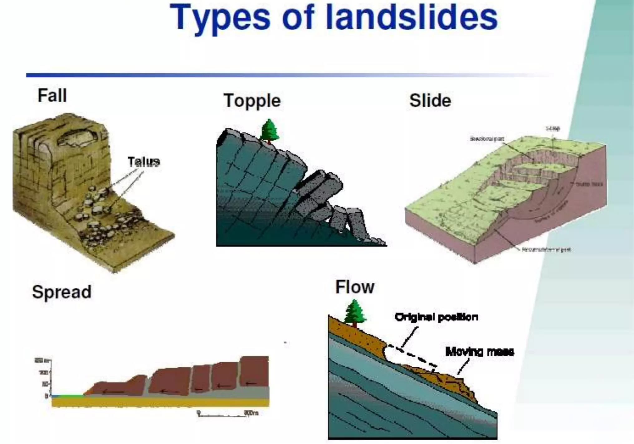
Landslides are classified into several types based on their movement characteristics:
- Slides: These are movements of soil or rock along a rupture surface or a zone of weakness. They can be further divided into rotational slides, where the rupture surface is curved, and translational slides, where the rupture surface is planar.
- Flows: These are movements of soil or rock that contain a large amount of water, which makes the mass flow like a fluid. They can be further divided into earth flows, debris flows, mudflows, and creep, depending on the material and the rate of movement.
- Spreads: These are movements of soil or rock that involve lateral extension and cracking of the mass. They are usually caused by liquefaction or plastic deformation of the material.
- Topples: These are movements of soil or rock that involve forward rotation and free-fall of the mass from a vertical or near-vertical cliff or slope.
- Falls: These are movements of soil or rock that detach from a steep slope or cliff and descend by free-fall, bouncing, or rolling.
What are the Reasons behind Landslides in Himalayan region?
- Fragile Ecosystem: Tectonic or neo-tectonic activities, associated with numerous subsurface processes like rock deformation, exhumation and reworking of rocks and surface processes such as erosion, weathering and rain/snow precipitation make the ecosystem inherently fragile.
- Earthquakes: The convergence of the Indian plate with the Eurasian plate in the Himalayan region has created subterranean stresses that get released in the form of earthquakes which, in turn, cause fractures and loosen the litho-structures near the mountain surface. This increases the possibilities of rock movement along the slope.
- Debris flow and underground water make a slope weak and landmass can slip down it.
- Earthquakes: The convergence of the Indian plate with the Eurasian plate in the Himalayan region has created subterranean stresses that get released in the form of earthquakes which, in turn, cause fractures and loosen the litho-structures near the mountain surface. This increases the possibilities of rock movement along the slope.
- Climate Induced Excessive Events: Climate-induced excessive events like freezing/thawing and heavy rain/snow precipitation lead to avalanches, landslides, debris flow, glacial lakes outburst floods, landslide lakes outburst floods and flash floods. They add to the precariousness of the mountain system. The Himalaya is further stressed by anthropogenic activities.
- Climate change has adverse impacts on glaciers, riverine systems, geomorphology and biodiversity, which, in turn, have increased the vulnerability of people in the mountainous states.
- Land degradation aggravates the problem.
- Climate change has adverse impacts on glaciers, riverine systems, geomorphology and biodiversity, which, in turn, have increased the vulnerability of people in the mountainous states.
- Anthropogenic Factors: Human activities such as road construction, tunneling, mining, quarrying, deforestation, urbanization, agriculture, excessive tourism and hydroelectric projects can also cause or worsen landslides in the Himalayas. These activities can disturb the natural balance of the slopes by removing vegetation cover, altering drainage patterns, increasing soil erosion, creating artificial cuts and fills, blasting rocks, and generating vibrations.
- These activities can also increase the exposure and risk of human settlements and infrastructure to landslides.
- The 2013 Kedarnath Tragedy was also influenced by the unplanned development and construction activities in the area, such as hotels, roads, bridges, and dams, that had altered the natural drainage system and increased the soil erosion.
- Geological Composition: Some of the Himalayan rocks are made of limestone, which is more prone to water and landslides than other types of rocks because it can dissolve in weakly acidic rainwater or groundwater. This process creates caves, sinkholes, and other karst features that weaken the stability of the slopes.
- Westerly Disturbance & Monsoon: Confluence of Westerly Disturbance — a low-pressure system, originating from the Mediterranean Sea, moving eastward across central Asia and northern India — and the South West Indian Summer Monsoon cause excessive and concentrated rainfall in parts of J&K, Himachal Pradesh and Uttarakhand leading to landslides and flash floods.
How are Landslides in Himalayan region different from Landslides in Western Ghats?
| Region | Causes |
| Himalayas |
|
| Western Ghats |
|
What are the Initiatives taken by the Government to mitigate the risk of landslides?
- National Landslide Risk Management Strategy (2019): This is a comprehensive document that addresses all the components of landslide disaster risk reduction and management, such as hazard mapping, monitoring, early warning system, awareness programs, capacity building, training, regulations, policies, stabilization and mitigation of landslides, etc
- Landslide Risk Mitigation Scheme (LRMS): This is a scheme under preparation that envisages financial support for site specific landslide mitigation projects recommended by landslide prone states, covering disaster prevention strategy, disaster mitigation and R&D in monitoring of critical landslides, thereby leading to the development of early warning system and capacity building initiatives.
- Flood Risk Mitigation Scheme (FRMS): This is another scheme under preparation that covers activities like pilot projects for development of model multi-purpose flood shelters and development of river basin specific flood early warning system and digital elevation maps for preparation of inundation models for giving early warning to the villagers for evacuation in case of flood.
- National Guidelines on Landslides and Snow Avalanches: These are guidelines prepared by the National Disaster Management Authority (NDMA) to guide the activities envisaged for mitigating the risk emanating from landslides at all levels. The guidelines cover aspects such as hazard assessment, vulnerability analysis, risk management, structural and non-structural measures, institutional mechanisms, financial arrangements, community participation, etc.
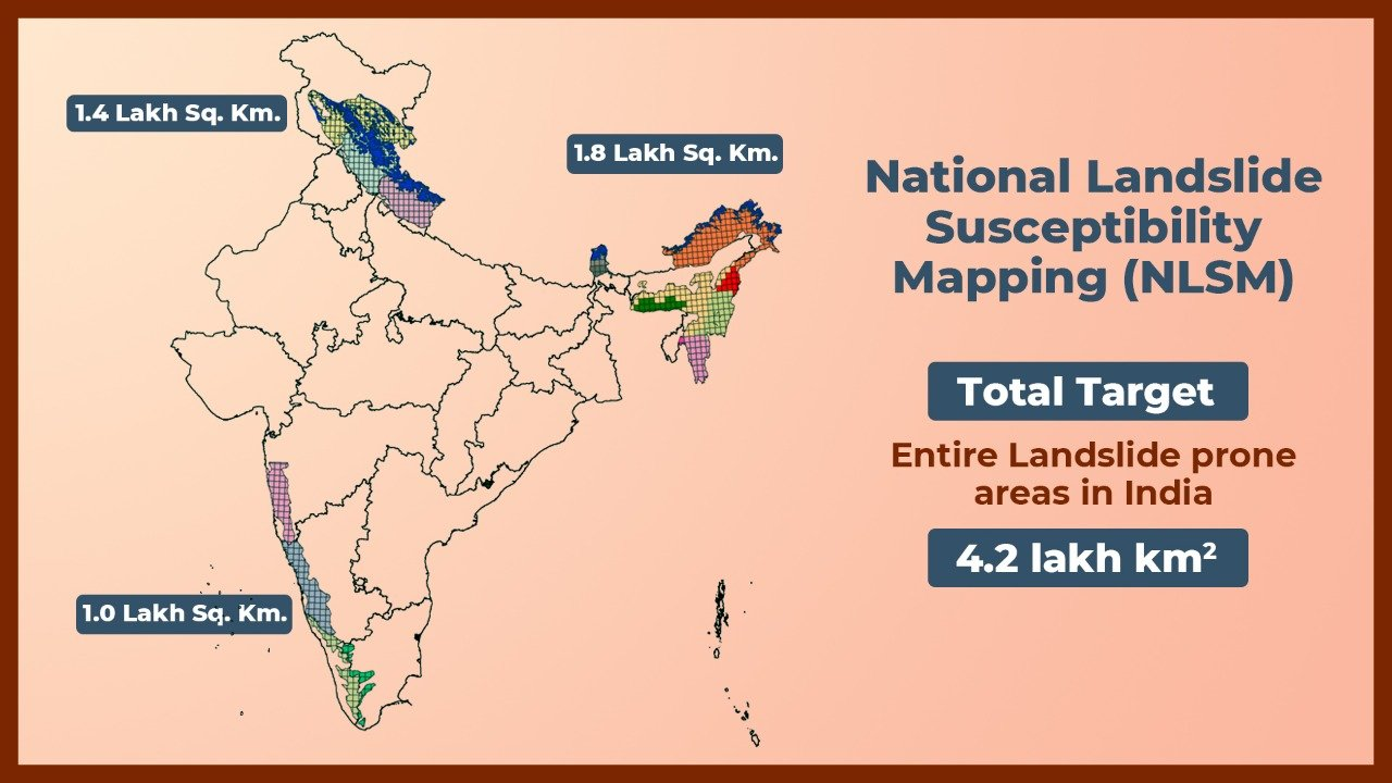
- Landslide Atlas of India: The Landslide Atlas of India is a document that provides the details of landslides present in landslide provinces of India, including damage assessment of specific landslide locations. It is prepared by the National Remote Sensing Centre (NRSC), one of the centers of ISRO.
What Measures should be taken?
- Resilience Building: To address these challenges, it's important to develop resilience against geo-hazards caused by natural processes, environmental degradation, and human activities. This involves implementing a network of sensors for real-time monitoring and data collection.
- Leveraging Technology for Effective Monitoring:
- Web-based sensors such as rain gauges, piezometers, inclinometers, extensometers, InSAR (Interferometric Synthetic Aperture Radar), and total stations can help monitor vulnerable areas. Monitoring should be prioritized in densely populated and built-up zones.
- Integrated Early Warning System (EWS): The development of an integrated Early Warning System (EWS) using AI and Machine Learning (ML) algorithms is crucial. Such a system could help predict and alert communities about impending hazards, giving them valuable time to take preventive measures.
- Formation of Himalayan States Council: Establishing a collaborative platform that brings together the disaster management authorities from different states in the Himalayan region is a strategic move. This centralized council would enable the sharing of knowledge, experiences, and resources to effectively assess and manage the impacts of various stressors on the region.
- Simulation and Hazard Assessment: The council should focus on simulating and assessing hazard scenarios resulting from natural processes, environmental degradation, climate-induced phenomena, and anthropogenic activities. This will help in understanding potential risks and formulating appropriate mitigation strategies.
- Knowledge Dissemination: While the Himalayan region is diverse and varied, sharing the findings of assessments across different states is essential. Collaborative efforts and shared knowledge can lead to a more comprehensive understanding of the challenges and potential solutions.
- Ecosystem Protection: Protecting the region's ecosystems is a priority. By promoting sustainable practices and responsible resource use, the council can help safeguard the natural environment.
- Sustainable Socio Economic Development: Recognizing the valuable natural resources present in the region, such as glaciers, springs, minerals, energy sources, and medicinal plants, offers the potential for sustainable socio economic development. However, it's crucial to strike a balance between resource exploitation and ecological preservation to ensure long-term viability.
- Environmental Considerations: Proper town planning that accounts for the unique characteristics of mountainous terrain is vital. Restricting heavy construction, implementing effective drainage systems, scientifically managing slope cutting, and using retaining walls are important aspects of environmentally conscious development.
- Retaining walls are relatively rigid walls used for supporting soil laterally so that it can be retained at different levels on the two sides.
- Building Codes and Assessment: High-resolution mapping of towns and assessing their load-bearing capacity are essential components in creating effective building codes. This approach ensures that construction is safe and resilient, especially in regions prone to natural hazards like landslides and earthquakes.
- Sustainable Tourism: Sustainable tourism can reduce landslides by promoting environmental awareness, conservation and protection of natural resources, and respect for biodiversity and ecosystems.
- It can also provide economic incentives and social benefits for local communities, which can enhance their resilience and adaptive capacity to cope with natural hazards.
- Building Sustainable Govt Projects: To ensure responsible development in the Himalayan region, key measures include conducting environmental assessments, using eco-friendly technologies, involving local communities, increasing stakeholder awareness, and promoting coordination among governmental sectors.
|
Drishti Mains Question: Discuss the increasing occurrence of landslides in the Himalayan region, focusing on the underlying factors, consequences, and potential measures to alleviate their impact. |
UPSC Civil Services Examination, Previous Year Questions (PYQs)
Mains:
Q. Differentiate the causes of landslides in the Himalayan region and Western Ghats. (2021)
Q. The Himalayas are highly prone to landslides.” Discuss the causes and suggest suitable measures of mitigation. (2016)


