Important Facts For Prelims
Israel's GPS Spoofing Against Iran
- 24 Apr 2024
- 4 min read
Why in News?
Recent reports suggest that Israel employed Global Positioning System (GPS) spoofing techniques to protect against Iranian missile attacks, reminiscent of past instances like United States (US) actions during the Kargil war in India.
What is GPS Spoofing?
- About:
- GPS spoofing is a technique used to manipulate the GPS signals to deceive receivers, making them believe they are at a different location than they are.
- This can involve broadcasting false GPS signals or altering genuine ones to mislead navigation systems, leading to inaccurate positioning information.
- Spoofing can be used for various purposes, including deceiving enemy navigation systems, protecting against unauthorised tracking, or creating false location data for malicious intents.
- Implications:
- Military Disruption: Misleading enemy navigation systems, leading to inaccurate targeting.
- Navigation Safety Risks: Potential accidents or collisions in maritime and aviation sectors.
- Critical Infrastructure Disruption: Disruption of essential services like power grids or transportation systems.
- Financial Fraud: Manipulation of location-based services for fraudulent transactions.
- National Security Threats: Deception of military or government agencies, espionage, and infiltration risks.
Did the US Engage in GPS Spoofing During the Kargil War?
- According to the reports, about 25 years ago, Pakistani soldiers crossed into India and took positions in Kargil in 1999. The Indian military requested GPS data for the region but was denied by the US.
- The US initially employed a technology called "selective availability" to intentionally introduce errors into civilian GPS receivers, reserving the best accuracy for military use.
- This technology was used to "degrade" GPS accuracy for the Indian military during the Kargil war, hindering their operations.
- India's Response:
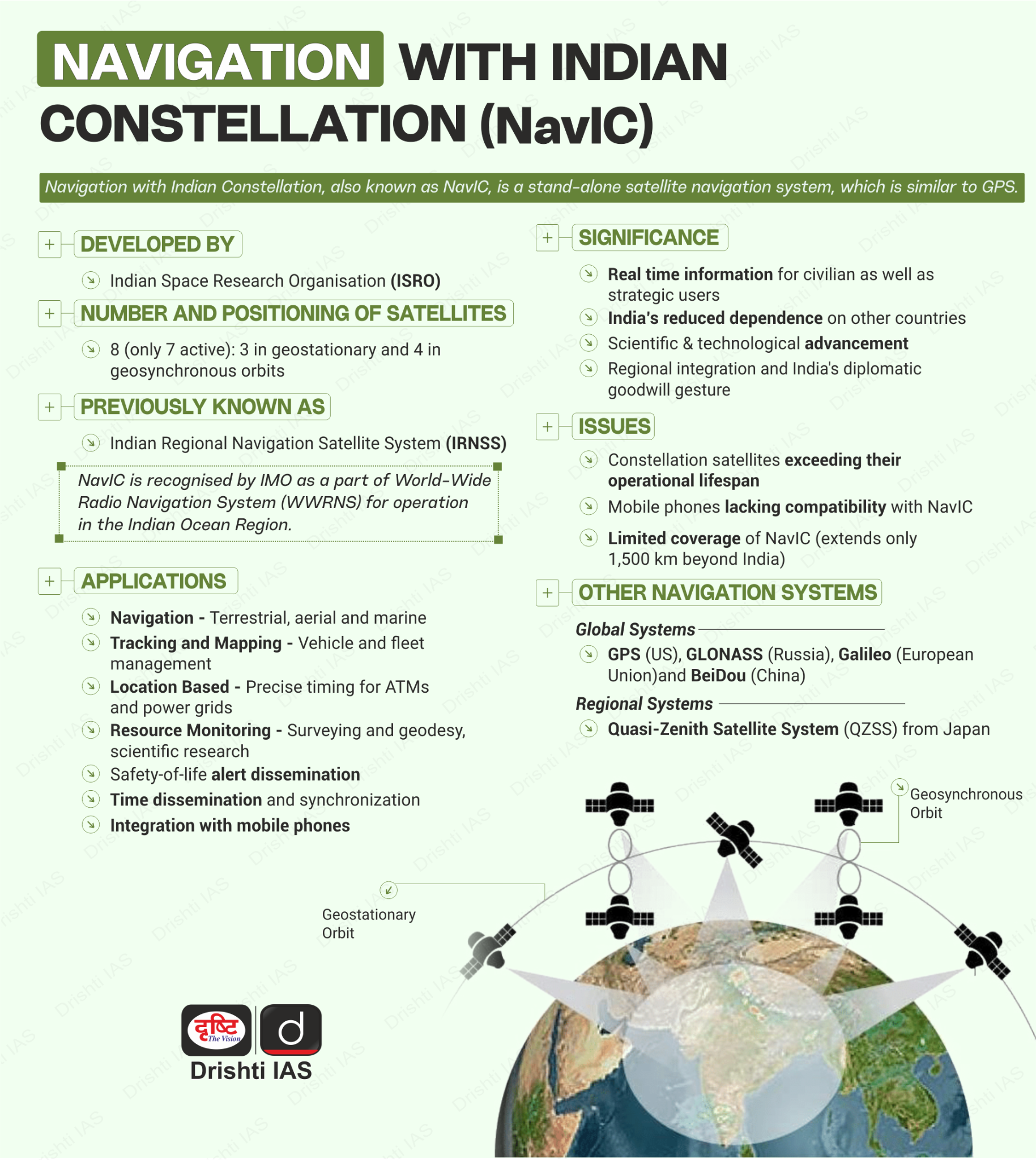
- India developed NavIC (Navigation with Indian Constellation), which was erstwhile known as the Indian Regional Navigation Satellite System (IRNSS) developed by the Indian Space Research Organisation (ISRO).
- NavIC provides precise and secure positioning, navigation, and timing services anywhere in India and 1500 kilometres beyond India's territorial boundary.
- NavIC offers two services:
- Standard Position Service (SPS) for civilian users and Restricted Service (RS) for strategic users.
- NavIC SPS signals are interoperable with the other global navigation satellite system (GNSS) signals namely GPS, Glonass (Russia), Galileo (European Union) and BeiDou (China).
UPSC Civil Services Examination, Previous Year Questions (PYQs)
Prelims
Q.1 Which one of the following countries has its own Satellite Navigation System? (2023)
a. Australia
b. Canada
c. Israel
d. Japan
Ans: d
Exp:
- Navigation Systems Operational in the World:
- GPS from the U.S.
- GLONASS from Russia.
- Galileo from European Union
- BeiDou from China.
- NavIC from India
- QZSS from Japan. Hence, option D is correct.
Q.2 With reference to the Indian Regional Navigation Satellite System (IRNSS), consider the following statements: (2018)
- IRNSS has three satellites in geostationary and four satellites in geosynchronous orbits.
- IRNSS covers entire India and about 5500 sq. Km beyond its borders.
- India will have its own satellite navigation system with full global coverage by the middle of 2019.
Which of the statements given above is/are correct?
(a) 1 only
(b) 1 and 2 only
(c) 2 and 3 only
(d) None
Ans: (a)


