Governance
Development of Great Nicobar
- 22 Nov 2022
- 7 min read
For Prelims: Great Nicobar Islands, Bay of Bengal, Indo-Pacific, Zoological Survey of India, Coral Reef.
For amins: Development of Great Nicobar and its Significance.
Why in News?
Recently, the Ministry of Environment, Forest and Climate Change has given environmental clearance for the ambitious Rs 72,000 crore development project on the strategically important Great Nicobar Island.
- The project is to be implemented in three phases over the next 30 years.
What is the Proposal?
- A greenfield city has been proposed, including an International Container Trans-shipment Terminal (ICTT), a greenfield international airport, and a power plant.
- The port will be controlled by the Indian Navy, while the airport will have dual military-civilian functions and will cater to tourism as well.
- A total 166.1 sq km along the southeastern and southern coasts of the island have been identified for project along a coastal strip of width between 2 km and 4 km.
- Some 130 sq km of forests have been sanctioned for diversion, and 9.64 lakh trees are likely to be felled.
What is the Purpose of Developing this Island?
- Economic Reasons:
- Great Nicobar is equidistant from Colombo to the southwest and Port Klang and Singapore to the southeast, and positioned close to the East-West international shipping corridor, through which a very large part of the world’s shipping trade passes.
- The proposed ICTT can potentially become a hub for cargo ships traveling on this route.
- As per the NITI Aayog report, the proposed port will allow Great Nicobar to participate in the regional and global maritime economy by becoming a major player in cargo transshipment.
- Strategic Reasons:
- The proposal to develop Great Nicobar was first floated in the 1970s, and its importance for national security and consolidation of the Indian Ocean Region has been repeatedly underlined.
- Increasing Chinese assertion in the Bay of Bengal and the Indo-Pacific has added great urgency to this imperative in recent years.
What are the Related Concerns?
- The proposed massive infrastructure development in an ecologically important and fragile region has alarmed many environmentalists.
- The loss of tree cover will not only affect the flora and fauna on the island, it will also lead to increased runoff and sediment deposits in the ocean, impacting the coral reefs in the area.
- Environmentalists have also flagged the loss of mangroves on the island as a result of the development project.
What are the Government's steps to address the concerns?
- The Zoological Survey of India is currently in the process of assessing how much of the reef will have to be relocated for the project.
- India has successfully translocated a coral reef from the Gulf of Mannar to the Gulf of Kutch earlier.
- A conservation plan for the leatherback turtle is also being put in place.
- As per the government, the project site is outside the eco-sensitive zones of Campbell Bay and Galathea National Park.
What are the Key Points of the Great Nicobar Islands?
- About:
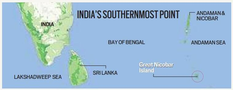
- Great Nicobar, the southernmost of the Andaman and Nicobar Islands, has an area of 910 sq km.
- The Andaman and Nicobar Islands are a cluster of about 836 islands in the eastern Bay of Bengal, the two groups of which are separated by the 150-km wide Ten Degree Channel.
- The Andaman Islands lie to the north of the channel, and the Nicobar Islands to the south.
- Indira Point on the southern tip of Great Nicobar Island is India’s southernmost point, less than 150 km from the northernmost island of the Indonesian archipelago.
- It covers 1,03,870 hectares of unique and threatened tropical evergreen forest ecosystems.
- It is home to a very rich ecosystem, including 650 species of angiosperms, ferns, gymnosperms, bryophytes, among others.
- In terms of fauna, there are over 1800 species, some of which are endemic to this area.
- Great Nicobar, the southernmost of the Andaman and Nicobar Islands, has an area of 910 sq km.
- Ecological Characteristics:
- The Great Nicobar Biosphere Reserve harbours a wide spectrum of ecosystems comprising tropical wet evergreen forests, mountain ranges reaching a height of 642 m (Mt. Thullier) above sea level, and coastal plains.
- Great Nicobar is home to two national parks, a biosphere reserve
- National Parks: Campbell Bay National Park and Galathea National Park
- Biosphere Reserve: Great Nicobar Biosphere Reserve.
- Tribe:
- The Mongoloid Shompen Tribe, about 200 in number, live in the forests of the biosphere reserve particularly along the rivers and streams.
- Another Mongoloid Tribe, Nicobarese, about 300 in number, used to live in settlements along the west coast.
- After the tsunami in 2004, which devastated their settlement on the western coast, they were relocated to Afra Bay in the North Coast and Campbell Bay.
UPSC Civil Services Examination, Previous Year Question (PYQ)
Q1. Which of the following have coral reefs? (2014)
- Andaman and Nicobar Islands
- Gulf of Kachchh
- Gulf of Mannar
- Sunderbans
Select the correct answer using the code given below:
(a) 1, 2 and 3 only
(b) 2 and 4 only
(c) 1 and 3 only
(d) 1, 2, 3 and 4
Ans: (a)
Q2. Consider the following statements: (2018)
- The Barren Island volcano is an active volcano located in the Indian territory.
- Barren Island lies about 140 km east of Great Nicobar.
- The last time the Barren Island volcano erupted was in 1991 and it has remained inactive since then.
Which of the statements given above is/are correct?
(a) 1 only
(b) 2 and 3
(c) 3 only
(d) 1 and 3
Ans: (a)
Q3. Which one of the following pairs of islands is separated from each other by the ‘Ten Degree Channel’? (2014)
(a) Andaman and Nicobar
(b) Nicobar and Sumatra
(c) Maldives and Lakshadweep
(d) Sumatra and Java
Ans: (a)


