Governance
Andaman and Nicobar Islands to Get Gas Plant
- 11 May 2022
- 7 min read
For Prelims: Island Coastal Zone Regulation 2019, Andaman and Nicobar Islands.
For Mains: Coastal Zone Regulation.
Why in News?
The Ministry of Environment, Forest and Climate Change has approved an exemption to the laws governing the regulation of coastal zones and has paved the way for gas-powered plants to be set up at Andaman and Nicobar islands.
What are the Key Points?
- The Island Coastal Zone Regulation (ICRZ), 2019, limits infrastructure development on vulnerable coastal stretches.
- The National Coastal Zone Management Authority (NCZMA) has recommended that gas-based power plants be permitted within the Island Coastal Regulation Zone area only on islands with geographical areas greater than 100 sq. km.
- A dual-fuel power plant that runs on both diesel and LNG is expected to be commissioned.
- There has been an increased interest in the development of the Andaman region following a policy push by the NITI Aayog. A proposed project plans to develop the Greater Andaman region or the southernmost stretch of the island group.
- Proposals include a 22-sq.km airport complex, a TransShipment Port (TSP) at South Bay at an estimated cost of Rs 12,000 crore, a parallel-to-the-coast mass rapid transport system and a free trade zone and warehousing complex on the southwestern coast.
What is ICRZ 2019?
- The Central Government declared certain coastal stretches as Coastal Regulation Zone and restrictions were imposed on the setting up and expansion of industries, operations and processes in the said zone.
- The Central Government has received representations from Andaman and Nicobar Administration regarding re-categorisation of Great Nicobar Island from Group –I to Group –II islands under the provisions of the Island Coastal Regulation Zone (ICRZ) notification.
- Group-I: Islands with geographical areas >1000 sq.km such as South Andaman, Middle Andaman, North Andaman and Great Nicobar.
- Group-II: Islands with geographical areas >100 sq.km but < 1000 sq.km such as Baratang, Little Andaman, Havelock and Car Nicobar.
- The land area from High Tide Line to 200 meters on the landward side along the sea front for Group-I Islands and 100 meters on the landward side along the sea front for Group-II Islands.
What is Coastal Regulation Zone?
- The coastal areas of seas, bays, creeks, rivers, and backwaters which get influenced by tides up to 500 m from the high tide line (HTL) and the land between the low tide line (LTL) and the high tide line have been declared as coastal regulation zone (CRZ) in 1991.
- HTL means the line on the land up to which the highest water line reaches during the spring tide.
- Low Tide Line means the line on the land up to which the lowest water line reaches during the spring tide.
- The coastal regulation zones have been declared by the Ministry of Environment, Forest and Climate change under the Environment Protection Act 1986.
- While the CRZ Rules are made by the Union environment ministry, implementation is to be ensured by state governments through their Coastal Zone Management Authorities.
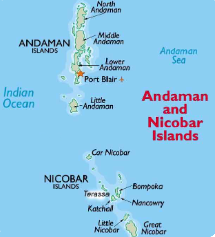
Andaman & Nicobar Islands
- The Andaman & Nicobar Islands is a union territory of India. This territory is known as A & N Islands, or ANI.
- It is located in the Indian Ocean, in the southern reaches of the Bay of Bengal, nearer to Indonesia and Thailand. This comprises of two island groups - the Andaman Islands and the Nicobar Islands - which separates the Andaman Sea to the east from the Indian Ocean.
- These two groups are separated by the 10° N parallel, the Andamans lying to the north of this latitude, and the Nicobars to the south. The capital of this territory is the Andamanese town of Port Blair.
- Hindi and English are the official languages of the islands. Bengali is the dominant and most spoken language, with 26% of the population speaking Bengali.
- Particularly vulnerable Tribal Groups (PTGs) who have been identified in the Andaman & Nicobar Islands. They are:-
- Great Andamanese of Strait Island
- Onges of Little Andaman
- Jarawas of South and Middle Andaman
- Sentinelese of Sentinel Islands
- Shompens of Great Nicobar
UPSC Civil Services Examination, Previous Year Questions (PYQs)
Q. Which one of the following regions of India has a combination of mangrove forest, evergreen forest and deciduous forest? (2015)
(a) North Coastal Andhra Pradesh
(b) South-West Bengal
(c) Southern Saurashtra
(d) Andaman and Nicobar Islands
Ans: (d)
Q. Which one of the following pairs of islands is separated from each other by the ‘Ten Degree Channel’? (2014)
(a) Andaman and Nicobar
(b) Nicobar and Sumatra
(c) Maldives and Lakshadweep
(d) Sumatra and Java
Ans: (a)
Q. Which of the following have coral reefs? (2014)
- Andaman and Nicobar Islands
- Gulf of Kachchh
- Gulf of Mannar
- Sunderbans
Select the correct answer using the code given below:
(a) 1, 2 and 3 only
(b) 2 and 4 only
(c) 1 and 3 only
(d) 1, 2, 3 and 4
Ans: (a)
Q. In which one of the following places is the Shompen tribe found? (2009)
(a) Nilgiri Hills
(b) Nicobar Islands
(c) Spiti Valley
(d) Lakshadweep Islands
Ans: (b)


