International Relations
Chinese Bridge on Pangong Tso
- 30 May 2022
- 7 min read
For Prelims: India-China Standoff, Pangong Tso Lake, Line of Actual Control, Kailash Range
For Mains: China’s Building Bridge across Pangong Tso Lake, its implication for India, Background of India-China Standoff
Why in News?
Recently, the Ministry of External Affairs has confirmed that China is building a second bridge on the Pangong Tso lake.
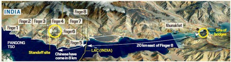
- The site of the bridge is around 20 km east of Finger 8 on the lake’s north bank – where the Line of Actual Control (LAC) passes.
- However, the actual distance by road is more than 35 km between the bridge site and Finger 8.
What are the Key Points?
- The construction site is just east of Khurnak Fort, where China has major frontier defence bases.
- China calls it Rutong Country.
- It has a frontier defence company at the Khurnak Fort, and further east, a water squadron deployed at Banmozhang.
- Although it is being built in territory that is under China’s control since 1958, the exact point is just west of India’s claim line.
- The Ministry of External Affairs considers the area as illegally occupied by China.
How will these Constructions Help China?
- The bridges are at one of the narrowest points on the lake, close to the LAC.
- These constructions will connect both sides of the lake, which would significantly cut down time for the People’s Liberation Army (PLA) to move troops and armored vehicles.
- The induction of troops from the G219 highway (Chinese national highway) would come down by 130 km due to this bridge.
Pangong Tso
- Pangong Tso is a 135-km long landlocked lake located at an altitude of over 14,000 feet i.e., 4350 m above sea level.
- Indian and China have around one-third and two-thirds of Pangong Tso Lake respectively.
- India has around 45 km of Pangong Tso under its control while approximately 60% of the lake, in terms of length, lies in China,
- The eastern end of Pangong Tso lies in Tibet.
- The lake, a glacial melt, has mountain spurs of the Chang Chenmo range jetting down, referred to as fingers.
- It is one of the highest altitude lakes in the world that is filled with saline water.
- However, even though it is a saline water lake, Pangong Tso freezes completely.
- The brackish water of this region has very low micro-vegetation.
- No aquatic life or fish, except crustaceans during winters are found.
- It is a kind of endorheic basin, which implies that it retains its water and does not allow outflow of its water to other external water bodies, such as oceans and rivers.
- Pangong Tso is popular for its changing colour ability.
- Its colour changes from shades of blue to green to red.
Why does China choose this location?
- The constructions are a direct outcome of the ongoing standoff that began in May 2020.
- The location is the consequence of an operation conducted by the Indian Army in August 2020 where Indian troops outmaneuvered the People’s Liberation Army to occupy the heights of Kailash Range in the Chushul sub-sector on the south bank of Pangong Tso.
- The positions allowed India to dominate the strategically significant Spanggur Gap, which could be used to launch an offensive as China had done in 1962.
- Also, India got a direct view of China’s Moldo Garrison (China’s military base). This was a cause of immense concern for the Chinese.
- After this operation, the Indian Army also readjusted on the lake’s north bank to position themselves above Chinese positions.
- The north bank was one of the first friction points to have come up in May 2020.
- During this jostling, warning shots were fired for the first time by both sides, a first in over four decades.
- New bridge will allow Chinese troops to slash travel time from around 12 hours at the moment to around four hours.
What is the current situation in the standoff?
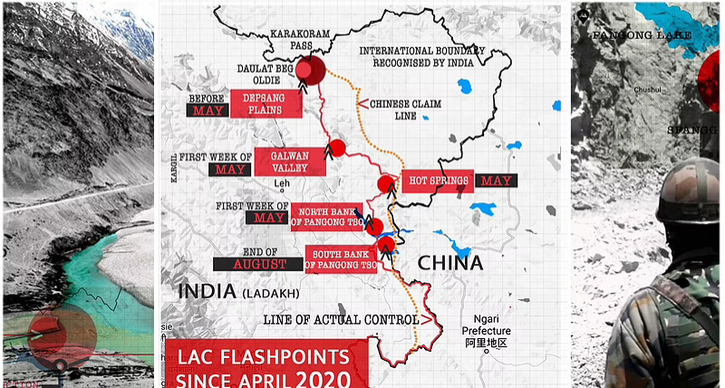
- India and China pulled their troops back from Patrolling Point (PP) 14 in Galwan Valley in June 2020, after the fatal clashes.
- Then they disengaged from the north and south banks of Pangong Tso in February 2021, and from PP17A near Gogra Post in August. But negotiations have been stuck since then.
- The Corps Commanders from both sides have met 15 times since the standoff began.
- The dates for the next round of talks are still awaited.
What has been India’s response?
- India is monitoring all Chinese activity closely.
- India has never accepted such illegal occupation and the unjustified Chinese claim or such construction activities in India’s territory.
- India is also upgrading and developing infrastructure along the northern border.
- In 2021, over 100 projects were completed by the Border Roads Organisation (BRO) in the border areas, most of which were close to the China border.
- India is also improving surveillance along the LAC.
UPSC Civil Services Examination, Previous Year Question
Q. Siachen Glacier is situated to the (2020)
(a) East of Aksai Chin
(b) East of Leh
(c) North of Gilgit
(d) North of Nubra Valley
Ans: (d)
Exp:
- The Siachen Glacier is located in the Eastern Karakoram range in the Himalayas, just northeast of Point NJ9842 where the Line of Control between India and Pakistan ends.
- It has the distinction of being the largest glacier outside the polar and subpolar regions.
- It lies to the west of Aksai Chin, north of Nubra valley and almost east of Gilgit. Therefore, option (d) is the correct answer


