Internal Security
New Army Aviation Brigade: LAC
- 05 Nov 2021
- 4 min read
Why in News
Recently, India raised a new army aviation brigade in the eastern sector of Line of Actual Control (LAC) in the Arunachal Pradesh sector.
- Also, China’s legislature has adopted a new border law that calls on the state and military to safeguard territory and “combat any acts” that undermine China’s territorial claims.
- The LAC is the demarcation that separates Indian-controlled territory from Chinese-controlled territory. The recent stand-off at Ladakh’s Galwan Valley has escalated due to the infrastructure projects that India has undertaken in recent years.
Key Points
- About:
- The new army aviation brigade was raised in March 2021 at Missamari air base, close to Tezpur, Assam and has capabilities such as Advanced Light Helicopters (ALH), US’ Cheetah helicopters and Israel’s Heron drones.
- While the function of the new brigade is largely for Intelligence, Surveillance and Reconnaissance (ISR) activities of the Army, it has the capability to support the Army for other objectives as well on the LAC.
- Line of Actual Control (LAC):
- Demarcation Line: Himachal Pradesh, Uttarakhand, Sikkim and Arunachal Pradesh and the Union Territory of Ladakh share a border with China.
- Sectors: The LAC is generally divided into three sectors namely: Western sector, Middle sector, and Eastern sector.
- Eastern Sector: In this sector, India shares a 1346 km long boundary with China.
- It spans Sikkim and Arunachal Pradesh.
- The alignment of the LAC in the eastern sector is along the 1914 McMahon Line.
- China considers the McMahon Line illegal and unacceptable claiming that Tibetan representatives who had signed the 1914 Convention held in Shimla which delineated the McMahon line on the map were not having rights to do so.
- China claims the entire Arunachal Pradesh as South Tibet.
- Middle Sector:
- In this sector, India shares about a 545 km long boundary with China which runs along the watershed from Ladakh to Nepal.
- Himachal Pradesh and Uttarakhand touch this border with Tibet (China) in this sector. Both sides do not have much disagreement over the border in this area.
- Western Sector:
- India shares about 1597 km of border with China. It is between the Union Territory of Ladakh (erstwhile state of Jammu and Kashmir) and Xinjiang Province of China.
- In this sector, there is a territorial dispute over Aksai Chin. India claims it as part of erstwhile Kashmir, while China claims it is part of Xinjiang.
- The boundary dispute in the Western Sector pertains to the Johnson Line proposed by the British in the 1860s that extended up to the Kunlun Mountains and put Aksai Chin in the then princely state of Jammu and Kashmir.
- Independent India used the Johnson Line and claimed Aksai Chin as its own.
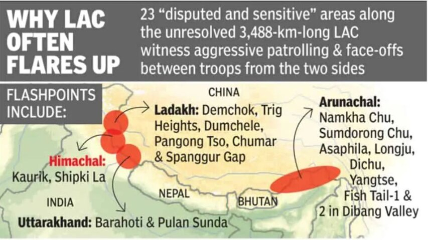
- Eleven of the 23 contested areas on the LAC are identified in Ladakh under the western sector, four in the middle sector and eight in the eastern sector.
- 23 contested areas were identified by the government through various mechanisms since India first accepted the concept of LAC in 1993.
- Eastern Sector: In this sector, India shares a 1346 km long boundary with China.