Geography
Rock Glaciers
- 12 Jan 2024
- 8 min read
For Prelims: Jhelum, Rock Glaciers, Glacial lake outburst floods, Landslides, Thermokarst, Batagaika crater
For Mains: Potential Consequences of Rock Glaciers, Factors Influence Glacial Dynamics, Impact of Glacial Retreat
Why in News?
A recent study has shed light on the presence of over 100 active permafrost structures in the Jhelum basin of the Kashmir Himalayas. These structures, known as rock glaciers, have significant implications for the region's hydrology and pose potential risks as the climate warms.
What are Rock Glaciers?
- About:
- Rock glaciers are a type of landform that consists of a mixture of rock fragments and ice.
- Rock glaciers typically form in mountainous regions where there is a combination of permafrost, rock debris, and ice.
- Permafrost is a permanently frozen layer on or under Earth's surface. It consists of soil, gravel, and sand, usually bound together by ice.
- One common scenario involves a pre-existing glacier that accumulates debris and rocks as it moves. Over time, if the glacier recedes or thaws, the debris-covered ice can transform into a rock glacier.
- These rock glaciers occur in highly elevated regions with steep slopes.
- To the naked eye, the rock glaciers look like regular ground, they require a geomorphological view for proper identification.
- Classification:
- They are classified as active or relict, depending on whether they have ice and movement or not. Active rock glaciers are more dynamic and hazardous, while relict rock glaciers are more stable and inert.
- Importance:
- Rock glaciers are important indicators of mountain permafrost, which is the permanently frozen ground that underlies many high-altitude regions.
- Rock glaciers also store significant amounts of water in their frozen cores, which could be a valuable resource in the face of water scarcity and glacial retreat.
What are the Potential Impacts of the Active Rock Glaciers on the Region?
- Glacial lake outburst floods (GLOFs):
- These are sudden and catastrophic floods that occur when a glacial lake bursts its natural or artificial dam, releasing large volumes of water and debris downstream.
- The active rock glaciers could increase the risk of GLOFs by destabilizing the slopes or the dams of glacial lakes.
- Rock glaciers near glacial lakes, such as Chirsar Lake and Bramsar Lake, increase the risk of GLOFs.
- These are sudden and catastrophic floods that occur when a glacial lake bursts its natural or artificial dam, releasing large volumes of water and debris downstream.
- Landslides:
- These are the rapid movements of soil, rock, or snow down a slope, often triggered by earthquakes, rainfall, or human activities.
- The active rock glaciers could cause landslides by weakening the slope stability or by melting and releasing water that could lubricate the sliding mass.
- The melting permafrost makes these areas unstable, posing risks to nearby settlements and critical infrastructure.
- For example, the Nunavik area in Quebec was mostly built on permafrost ground many years ago. In the last decades, the ice in the underlying layers began to melt due to global warming, increasing the frequency of mudslides and other dangers.
- These are the rapid movements of soil, rock, or snow down a slope, often triggered by earthquakes, rainfall, or human activities.
- Thermokarst:
- This is a type of terrain that is characterized by irregular surfaces of marshy hollows and small hummocks (ridges), formed by the thawing of ice-rich permafrost.
- The active rock glaciers could lead to the formation of thermokarst features, such as ponds or lakes, that could alter the hydrology, ecology, and carbon cycle of the region.
- The presence of water bodies near Kulgam town, Jammu and Kashmir suggests the existence of permafrost underground, resembling 'thermokarst lakes', which can pose further risks.
- The melting of ice underneath the earth’s surface is a high risk of collapse. The collapse leads to formation of a landscape whose features are sinkholes, hummocks, caverns, and tunnels.
- The Batagaika crater is an example of thermokarst, it is the biggest permafrost crater in the world, it belongs to the Sakha Republic, Russia.
- This is a type of terrain that is characterized by irregular surfaces of marshy hollows and small hummocks (ridges), formed by the thawing of ice-rich permafrost.
Jhelum Basin of the Kashmir Himalayas
- The Jhelum basin is drained by the upper Jhelum River, which originates from a deep spring at Vernag at Anantnag, situated at the base of the Pir Panjal range in the Kashmir Valley, the river passes through Srinagar and Wular Lake before entering Pakistan.
- As a tributary of the Indus River, the Jhelum contributes to the larger river system in the Indian subcontinent.
- The river flows through Jammu and Kashmir and into Pakistan, where it joins the Chenab River.
- The primary tributary is the Kishenganga (Neelum) River. The Kunhar River, another significant tributary, connects Pakistan-occupied Kashmir and Pakistan via the Kohala Bridge in the Kanghan Valley.
Way Forward
- The study highlights the critical role of permafrost research in understanding and mitigating the impacts of climate change in the Himalayan region.
- Allocate resources for further studies on the hydrological potential of active rock glaciers, exploring ways to harness the stored water for sustainable use in regions facing water scarcity.
- Develop and implement early warning systems in regions with identified active rock glaciers to alert communities and authorities about potential disasters.
- Integrate findings from permafrost studies into regional and national climate change adaptation plans, considering the specific challenges posed by the transition from glaciers to rock glaciers.
- There is a need to raise awareness among local communities, planners, and policymakers about the risks associated with permafrost degradation.
UPSC Civil Services Examination, Previous Year Question (PYQ)
Prelims
Q. With reference to the Indus river system, of the following four rivers, three of them pour into one of them which joins the Indus directly. Among the following, which one is such a river that joins the Indus direct? (2021)
(a) Chenab
(b) Jhelum
(c) Ravi
(d) Sutlej
Ans: (d)
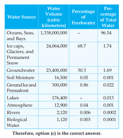
Q. On the planet earth, most of the freshwater exists as ice caps and glaciers. Out of the remaining freshwater, the largest proportion (2013)
(a) is found in atmosphere as moisture and clouds
(b) is found in freshwater lakes and rivers
(c) exists as groundwater
(d) exists as soil moisture
Ans: C
Exp:
Mains:
Q. How does the cryosphere affect global climate? (2017)


