Science & Technology
NavIC Integration in Smartphones
- 16 Sep 2023
- 6 min read
For Prelims: NavIC (Navigation with Indian Constellation), Indian Space Research Organisation (ISRO), Production-Linked Incentive (PLI), International Maritime Organization, GPS (Global Positioning System).
For Mains: NavIC Integration in Smartphones and its Significance for India.
Why in News?
The Ministry of Electronics and Information Technology, Government of India, is planning on making it mandatory for all devices to support the homegrown Navigation System NavIC (Navigation with Indian Constellation).
- This comes at a time when the newly launched Apple iPhone 15 has integrated the navigation system developed by the Indian Space Research Organisation (ISRO) into its hardware.
- India's NavIC is not intended to replace other global navigation systems but rather complement them.
What are the Government's Plans for NavIc Integration on Smartphones?
- The Union government is considering mandating NavIC integration in all smartphones sold in India by 2025, particularly targeting 5G phones.
- Manufacturers could receive additional incentives through Production-Linked Incentive (PLI) schemes for using chips that support NavIC technology, fostering domestic chip design and production.
What are the Roadmap and Future Prospects for NavIC Adoption?
- To bolster NavIC's adoption, ISRO had launched second-generation Navigation satellites in May 2023 that will enhance interoperability with other satellite-based navigation systems and expand usage.
- The second-generation satellites will send signals in a third frequency, L1, besides the L5 and S frequency signals that the existing satellites provide.
- The L1 frequency is among the most commonly used in the Global Positioning System (GPS) and will increase the use of the regional navigation system in wearable devices and personal trackers that use low-power, single-frequency chips.
- This strategic move aligns with India's aspirations to establish technological sovereignty and emerge as a dominant space-faring nation.
What is Navigation with Indian Constellation (NavIC)?
- About:
- India's NavIC is an independent navigation satellite system developed by ISRO becoming operational in 2018.
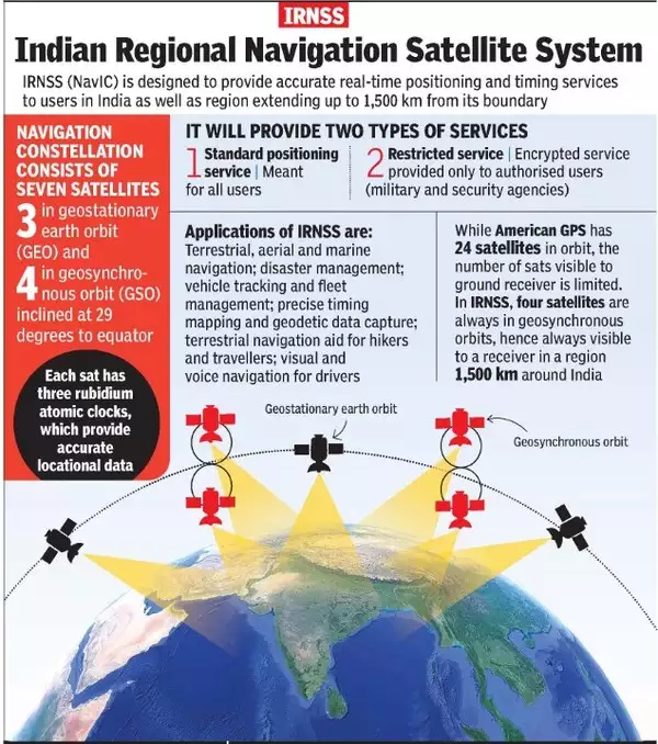
- It is providing accurate real-time positioning and timing services over
- India and a region extending approximately 1500 km around the Indian Mainland.
- It is designed with a constellation of 7 satellites and a network of ground stations operating 24×7.
- There are a total of eight satellites however only seven remain active.
- Three satellites in geostationary orbit and four satellites in geosynchronous orbit.
- Recognition:
- It was recognised by the International Maritime Organization (IMO) as a part of the World-Wide Radio Navigation System (WWRNS) for operation in the Indian Ocean Region in 2020.
- Potential Uses:
- Terrestrial, aerial and marine navigation;
- Disaster management;
- Vehicle tracking and fleet management (especially for mining and transportation sector);
- Integration with mobile phones;
- Precise timing (as for ATMs and power grids);
- Mapping and geodetic data capture.
What is the Significance of Integrating NavIC in Smartphones for India?
- Strategic Technological Autonomy:
- NavIC reduces dependence on foreign global navigation systems like GPS (Global Positioning System), showcasing India's ability to develop and deploy critical technology independently.
- Ensures that the nation can control and secure its vital navigation infrastructure, which is crucial for national security and defense applications.
- Enhanced Accuracy and Reliability:
- NavIC provides highly accurate and reliable positioning and timing information, especially in the Indian subcontinent and the surrounding region.
- Better accuracy is essential for a range of applications, from Disaster Management and agriculture to urban planning and transportation, improving overall efficiency and decision-making.
- Tailored Solutions for Indian Terrain:
- NavIC is designed to offer superior performance in the specific geographical and topographical conditions of India, where conventional global navigation systems may have limitations.
- Tailoring the navigation system to suit India's diverse landscape ensures a more precise and efficient location-based service.
- Broadening Use Cases and Innovation:
- NavIC's integration opens up opportunities for a plethora of location-based services, navigation apps, and other innovative solutions that can be tailored to specific local needs and preferences.
- This spurs entrepreneurship and supports a thriving app development ecosystem, encouraging creativity and innovation in technology.
What are the other Navigation Systems operational in the world?
- Four Global Systems:
- GPS from the U.S.
- GLONASS from Russia.
- Galileo from European Union
- BeiDou from China.
- Two Regional Systems:
- NavIC from India
- QZSS from Japan.
UPSC Civil Services Examination, Previous Year Question (PYQ)
Q.1 Which one of the following countries has its own Satellite Navigation System? (2023)
a. Australia
b. Canada
c. Israel
d. Japan
Ans: d
Q.2 With reference to the Indian Regional Navigation Satellite System (IRNSS), consider the following statements: (2018)
- IRNSS has three satellites in geostationary and four satellites in geosynchronous orbits.
- IRNSS covers entire India and about 5500 sq. Km beyond its borders.
- India will have its own satellite navigation system with full global coverage by the middle of 2019.
Which of the statements given above is/are correct?
(a) 1 only
(b) 1 and 2 only
(c) 2 and 3 only
(d) None
Ans: (a)
Mains
Q.1 Why is Indian Regional Navigational Satellite System (IRNSS) needed? How does it help in navigation? (2018)


