Biodiversity & Environment
Great Nicobar Project EIA Downplays Earthquake Risk
- 09 Jul 2025
- 10 min read
For Prelims: Great Nicobar Infrastructure Project (GNIP), Environment Impact Assessment (EIA), Earthquake, Plate Boundary, Sunda Trench, Pacific Ring of Fire, Tropical Rainforest, Leatherback Sea Turtles, Galathea Bay Wildlife Sanctuary, Shompen, Malacca, International Container Transshipment Terminal (ICTT).
For Mains: Great Nicobar Island (GNI) project and its significance, Concerns associated with GNIP steps needed to address these concerns.
Why in News?
The proposed Rs 72,000-crore Great Nicobar Infrastructure Project (GNIP) has sparked concerns, as an IIT-Kanpur report highlighted safety risks associated with the region’s status as a highly seismic zone, which was hit by a devastating tsunami in 2004.
What are the Key Findings of IIT-Kanpur Report that Highlighted the Vulnerabilities of the Great Nicobar Project?
- Potential for Future Mega Earthquake: It estimates a ‘return period’ of 420–750 years for mega-earthquakes (magnitude of 9 or more) and 80–120 years for large-magnitude earthquakes (>7.5), indicating high seismic vulnerability.
- However, the Environmental Impact Assessment (EIA) report states that the likelihood of a mega-earthquake (similar to the 2004 9.1-magnitude quake) is low.
- Geological Evidence of Past Tsunamis: Sediment analysis from Badabalu beach in South Andaman revealed evidence of at least seven large tsunami events over the past 8,000 years, pointing to a long history of major seismic activity in the region.
- Need for Site-Specific Studies: Site-specific seismic and tsunami studies must be conducted in Nicobar Islands, especially in areas like Car Nicobar and Campbell Bay, which are lacking such assessments.
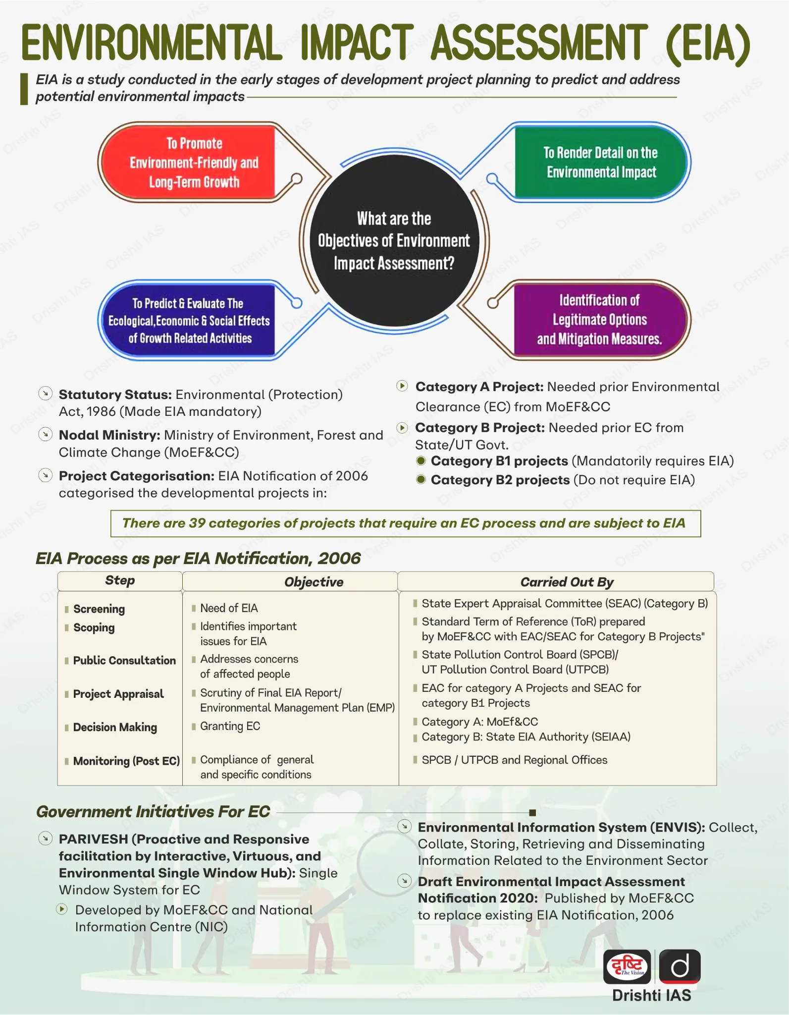
What is the Great Nicobar Island Project?
- About: Launched in 2021, GNIP is a mega infrastructure initiative to be implemented on Great Nicobar Island (GNI), located at the southern end of the Andaman and Nicobar Islands.
- Features: Spearheaded by NITI Aayog, it includes a transshipment terminal at Galathea Bay, a greenfield airport, a greenfield township, and a tourism project with a gas-powered plant.
- It is being executed by the Andaman and Nicobar Islands Integrated Development Corporation (ANIIDCO) and is strategically located near the Malacca Strait, a key maritime route linking the Indian Ocean to the Pacific Ocean.
- Significance:
- Strategic Importance: Nicobar’s strategic location near the Malacca, Sunda, and Lombok Straits enables India to monitor crucial sea routes vital for global trade and energy supply, aligning with the Act East Policy (2014) and the QUAD’s Indo-Pacific strategy.
- The planned greenfield airport will enhance defense deployment, boosting India’s capacity to track Chinese naval movements and reinforce regional security.
- Economic Significance: The International Container Transshipment Terminal (ICTT) aims to reduce India’s dependence on foreign ports like Singapore and Colombo.
- It forms a key part of the Maritime India Vision 2030 and Amrit Kaal Vision 2047, aligning with India’s long-term economic strategy.
- Strategic Importance: Nicobar’s strategic location near the Malacca, Sunda, and Lombok Straits enables India to monitor crucial sea routes vital for global trade and energy supply, aligning with the Act East Policy (2014) and the QUAD’s Indo-Pacific strategy.
Great Nicobar Island
- About: Great Nicobar is the southernmost and largest island of the Nicobar group in the southeastern Bay of Bengal, and is mostly covered in tropical rainforest.
- Indira Point, situated on Great Nicobar Island, is the southernmost point of India.
- Geographical Division: The Andaman and Nicobar Islands comprise 836 islands, divided into Andaman (north) and Nicobar (south), separated by the 150-km-wide 10° Channel.
- Ecological Importance: Great Nicobar island is home to two national parks—Campbell Bay National Park and Galathea National Park and a biosphere reserve, the Great Nicobar Biosphere Reserve.
- Tribes: It is inhabited by small populations of indigenous tribes, including the Shompen, Onge, Andamanese, and Nicobarese.
What Concerns Are Associated with the Great Nicobar Island Project?
- Environmental Concerns:
- Rampant Deforestation: The project will clear 130 sq km of primary tropical rainforest, causing biodiversity loss, with actual tree felling possibly exceeding 10 million, far above initial estimates of 8.65–9.64 lakh.
- Wildlife Disruption: The project threatens leatherback sea turtles in the Galathea Bay Wildlife Sanctuary, designated in 1997 for their conservation, was denotified in 2021 for the port—contradicting India’s Marine Turtle Action Plan (2021).
- The coastline is classified as Coastal Regulation Zone (CRZ 1A), where ship-repair and other industrial activities pose a significant threat to marine ecosystems.
- Compensatory Afforestation Issues: The diversion of pristine Nicobar forests is being “compensated” with land in Haryana and Madhya Pradesh, which fails to replicate the lost biodiversity.
- Geological Concerns: The island's tertiary sandstone, limestone, and shale over volcanic rocks amplify seismic shaking and are prone to liquefaction during earthquakes.
- Legal Concerns: The SC appointed Shekhar Singh Commission 2002 recommended a total ban on tree felling in tribal reserves and national parks, along with afforestation before felling—a rule currently not being followed.
- The project's environmental clearance, justified by national security, is contested due to lack of consultation and transparency, and its potential to harm the Shompen tribe by endangering their forest-based livelihood.
Note: CRZ 1A, under the Coastal Zone Management Plan 2019, covers ecologically sensitive coastal areas like coral reefs, crucial for biodiversity and ecosystem stability.
What Measures can be Adopted to Ensure the Sustainability of the Great Nicobar Island Project?
- Safeguarding Ecological Integrity: Conduct a comprehensive biodiversity assessment to identify critical habitats and explore alternative sites for infrastructure development, ensuring full compliance with environmental laws.
- Additionally, prioritize the restoration of degraded forests across the Andaman and Nicobar Islands to maintain ecological balance.
- Ensuring Indigenous Rights and Inclusion: Minimize the displacement of indigenous communities like the Shompens and Nicobarese, ensure fair compensation, provide livelihood support and skill development, and establish a community council to ensure inclusive and participatory decision-making.
- Enhancing Institutional Transparency: Establish an independent monitoring body including environmentalists, local representatives, and government officials to ensure compliance with safeguards, maintain transparency, and uphold accountability throughout project implementation.
- Resilient and Sustainable Resource Use: Promote sustainable management of water, food, and energy resources, while strengthening climate-resilient infrastructure and enhancing the region’s disaster preparedness to reduce future vulnerabilities.
Conclusion
The Great Nicobar Project, while strategically significant, faces critical ecological and seismic risks. A balanced approach—incorporating rigorous scientific assessments, protecting biodiversity, respecting tribal rights, and ensuring disaster-resilient infrastructure—is essential. Sustainable development must prioritize long-term environmental security alongside economic and strategic goals to avoid irreversible damage to this fragile island ecosystem.
|
Drishti Mains Question: Evaluate the strategic and environmental implications of the Great Nicobar Infrastructure Project. |
UPSC Civil Services Examination, Previous Year Question (PYQ)
Prelims
Q. Consider the following statements: (2018)
- The Barren Island volcano is an active volcano located in the Indian territory.
- Barren Island lies about 140 km east of Great Nicobar.
- The last time the Barren Island volcano erupted was in 1991 and it has remained inactive since then.
Which of the statements given above is/are correct?
(a) 1 only
(b) 2 and 3
(c) 3 only
(d) 1 and 3
Ans: (a)
Q. Which one of the following pairs of islands is separated from each other by the ‘Ten Degree Channel’? (2014)
(a) Andaman and Nicobar
(b) Nicobar and Sumatra
(c) Maldives and Lakshadweep
(d) Sumatra and Java
Ans: (a)
Mains
Q. Project ‘Mausam’ is considered a unique foreign policy initiative of Indian government to improve relationship with its neighbours. Does the project have a strategic dimension? Discuss. (2015)


