Science & Technology
Geospatial Technology
- 21 Feb 2022
- 7 min read
For Prelims: SVAMITVA Scheme, geospatial technology.
For Mains: Significance of SVAMITVA Scheme for Rural India.
Why in News?
On the Occasion of the 1st Anniversary of the Release of Geospatial Data, the Government said that geospatial technology along with Drones will survey all the over 6 lakh Indian villages under the SVAMITVA scheme. Also the pan-India 3D Maps will be prepared for 100 Indian cities.
- Geospatial Policy will be announced soon as the liberalisation of the guidelines has yielded very positive outcomes within one year’s time.
- SVAMITVA Scheme is a reformative step towards establishment of clear ownership of property in rural inhabited (Abadi) areas.
What is Geospatial Technology?
- Geospatial technology uses tools like GIS (Geographic Information System), GPS (Global Positioning System) and Remote Sensing for geographic mapping and analysis.
- These tools capture spatial information about objects, events and phenomena (indexed to their geographical location on earth, geotag). The location data may be Static or Dynamic.
- Static location data include position of a road, an earthquake event or malnutrition among children in a particular region while dynamic location data include data related to a moving vehicle or pedestrian, the spread of an infectious disease etc.
- The technology may be used to create intelligent maps to help identify spatial patterns in large volumes of data.
- The technology facilitates decision making based on the importance and priority of scarce resources.
What about India’s Geospatial Sector?
- India has a robust ecosystem in geospatial, with the Survey of India (SoI), the Indian Space Research Organisation (ISRO), Remote Sensing Application Centres (RSACs), and the National Informatics Centre (NIC) in particular, and all ministries and departments, in general, using geospatial technology.
- In 2021, the geospatial market was dominated by defence and intelligence (14.05 %), urban development (12.93 %) and utilities (11 %) segments, cumulatively accounting for 37.98% of the total geospatial market.
- In 2021, the Ministry of Science and Technology released new guidelines for the Geo-Spatial Sector in India, which deregulates existing protocol and liberalises the sector to a more competitive field.
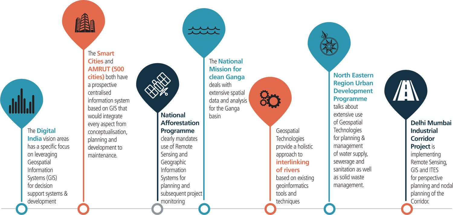
Why is Geospatial Technology important for India?
- A Potential Sector: The sector has potential to grow to Rs 63,100 crore at 12.8% by the end of 2025 as per India Geospatial Artha Report 2021.
- Employment: Private Companies like Amazon, Zomato etc. use this technology to smoothly conduct their delivery operations which supports livelihood generation.
- Implementation of Schemes: The schemes like the Gati Shakti program can be smoothly implemented using geospatial technology.
- Make in India: Focusing on the sector allows Indian companies to develop indigenous apps like an Indian version of google maps.
- Management of Land records: Using the technology, the data related to a large number of landholdings can be appropriately tagged and digitised.
- It will not only help better targeting but also reduce the quantum of land disputes in courts.
- Crisis Management: Technology and logistics were perfectly supported through the use of geospatial technology during the Covid-19 vaccination drive.
- Intelligent Maps and Models: Geospatial technology may be used to create intelligent maps and models that may be interactively queried to get the desired results in a STEM (Science Technology Engineering and Mathematics) application or may be used to advocate social investigations and policy-based research.
What are the Challenges?
- There is no demand for geospatial services and products on a scale linked to India’s potential and size.
- This is mainly due to the lack of awareness among potential users in government and private.
- The other hurdle has been the lack of skilled manpower across the entire pyramid.
- The unavailability of foundation data, especially at high-resolution, is also a constraint.
- Essentially, foundation data can be seen as common data tables which are shared between multiple applications or processes which are supposed to create a sturdy foundation for good service automation and management
- The lack of clarity on data sharing and collaboration prevents co-creation and asset maximisation.
- There are still no ready-to-use solutions especially built to solve the problems of India.
Way Forward
- Establishing a Geo-Portal and Data Cloud: There is a need to establish a geo-portal to make all public-funded data accessible through data as a service model.
- It is important to inculcate the culture of data sharing, collaboration and co-creation.
- Generation of Foundation Data: This should include the Indian national digital Elevation Model (InDEM), data layers for cities, and data of natural resources.
- Bachelor’s Programme in Geospatial: India should start a bachelor’s programme in geospatial in the Indian Institutes of Technology and the National Institutes of Technology. Besides these, there should be a dedicated geospatial university.
- These programmes will propel research and development efforts which are crucial for the development of technologies and solutions locally.
- Regulation: National organisations like SoI and ISRO should be entrusted with the responsibility of regulation and the projects related to the nation’s security and scientific significance.
- These organisations should not compete with entrepreneurs for government business as the latter remains in a disadvantageous position.
- Finalisation of Policies: The draft National Geospatial Policy (NGP) and the Indian Satellite Navigation Policy (SATNAV Policy) should be duly finalized to augment the sector.


