Geography
Earthquake
- 10 Nov 2022
- 6 min read
For Prelims: India and Eurasia Plates, Types of Earthquakes.
For Mains: Earthquake, its Distribution and Types.
Why in News?
Recently, Powerful tremors were felt in India after an earthquake of magnitude 6.6 struck Nepal, which killed a few people and destroyed multiple houses.
What Caused these Tremors?
- According to the United States Geological Survey (USGS) the tremors are attributed to the continental collisions of India and Eurasia Plates, which is the dominating force for the Seismicity in the Himalayas.
- These plates are converging at a relative rate of 40-50 millimeters per year.
- Northward under thrusting of India beneath Eurasia generates numerous earthquakes and consequently makes this area one of the most seismically hazardous regions on Earth.
- The Himalayas and their vicinity have witnessed some of the most lethal earthquakes such as one of magnitude 8.1 Bihar in 1934, the 1905 magnitude 7.5 quake in Kangra and the 2005 magnitude 7.6 quake in Kashmir.
What is an Earthquake?
- About:
- An earthquake in simple words is the shaking of the earth. It is a natural event. It is caused due to release of energy, which generates waves that travel in all directions.
- The vibrations called seismic waves are generated from earthquakes that travel through the Earth and are recorded on instruments called seismographs.
- The location below the earth’s surface where the earthquake starts is called the hypocenter, and the location directly above it on the surface of the earth is called the epicenter.
- Types of Earthquake: Fault Zones, Tectonic Earthquakes, Volcanic Earthquake, Human Induced Earthquakes.
- The earthquake events are scaled either according to the magnitude or intensity of the shock. The magnitude scale is known as the Richter scale. The magnitude relates to the energy released during the quake. The magnitude is expressed in absolute numbers, 0-10.
- The intensity scale is named after Mercalli, an Italian seismologist. The intensity scale takes into account the visible damage caused by the event. The range of intensity scale is from 1-12.
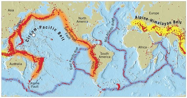
- Distribution of Earthquake:
- Circum-Pacific Seismic Belt: The world's greatest earthquake belt, the circum-Pacific seismic belt, is found along the rim of the Pacific Ocean, where about 81% of our planet's largest earthquakes occur. It has earned the nickname "Ring of Fire".
- The belt exists along boundaries of tectonic plates, where plates of mostly oceanic crust are sinking (or subducting) beneath another plate. Earthquakes in these subduction zones are caused by slip between plates and rupture within plates.
- Mid Continental Belt: The Alpine-Himalayan belt (mid-Continental belt) extends from Europe to Sumatra through the Himalayas, the Mediterranean, and out into the Atlantic.
- This belt accounts for about 17% of the world's largest earthquakes, including some of the most destructive.
- Mid-Atlantic Ridge: The third prominent belt follows the submerged mid-Atlantic Ridge. The ridge marks where two tectonic plates are spreading apart (a divergent plate boundary).
- Most of the mid-Atlantic Ridge is deep underwater and far from human development.
- Circum-Pacific Seismic Belt: The world's greatest earthquake belt, the circum-Pacific seismic belt, is found along the rim of the Pacific Ocean, where about 81% of our planet's largest earthquakes occur. It has earned the nickname "Ring of Fire".
What is the Seismic Hazard Map of India?
- India is one of the highly earthquake affected countries because of the presence of technically active young fold mountains - Himalaya.
- India has been divided into four seismic zones (II, III, IV, and V) based on scientific inputs relating to seismicity, earthquakes that occurred in the past and tectonic setup of the region.
- Previously, earthquake zones were divided into five zones with respect to the severity of the earthquakes but the Bureau of Indian Standards (BIS) grouped the country into four seismic zones by unifying the first two zones.
- BIS is the official agency for publishing the seismic hazard maps and codes.
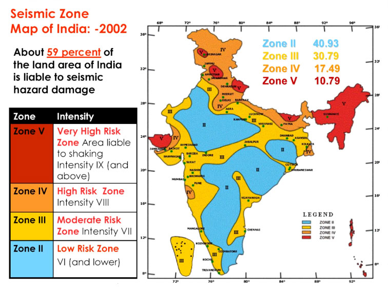
- Seismic Zone II:
- Area with minor damage earthquakes corresponding to intensities V to VI of MM scale (MM-Modified Mercalli Intensity scale).
- Seismic Zone III:
- Moderate damage corresponding to intensity VII of MM scale.
- Seismic Zone IV:
- Major damage corresponding to intensity VII and higher of MM scale.
- Seismic Zone V:
- Area determined by the seismics of certain major fault systems and is seismically the most active region.
- Earthquake zone V is the most vulnerable to earthquakes, where historically some of the country’s most powerful shocks have occurred.
- Earthquakes with magnitudes in excess of 7.0 have occured in these areas, and have had intensities higher than IX.
UPSC Civil Services Examination Previous Year Question (PYQ)
Q. The frequency of earthquakes appears to have increased in the Indian subcontinent. However, India’s preparedness for mitigating their impact has significant gaps. Discuss various aspects. (2015)
Q. Discuss about the vulnerability of India to earthquake related hazards. Give examples including the salient features of major disasters caused by earthquakes in different parts of India during the last three decades. (2021)


