Geography
Water Level in Mullaperiyar Dam
- 29 Oct 2021
- 4 min read
Why in News
Recently, the Supreme Court has directed the Supervisory Committee to take an immediate and firm decision on the maximum water level that can be maintained at Mullaperiyar dam amidst torrential rains in Kerala.
- The Ministry of Jal Shakti has constituted a three-member Supervisory Committee to settle the issue of Mullaperiyar dam between Kerala and Tamil Nadu.
Key Points
- About:
- Centre of a Decades-old Dispute:
- For Kerala, where it is situated, the dam presents a threat to lakhs living downstream,
- For Tamil Nadu, which controls the dam, the water it provides is the lifeline of people in five districts.
- Reasons for Recent Revival of the Dispute:
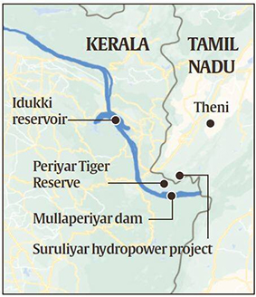
- Recently, heavy rains have increased water flow in Mullaperiyar dam. The excess water from Mullaperiyar can flow to downstream Idukki reservoir, which can lead to floods.
- The SC in 2018 had agreed that the water level in the Mullaperiyar reservoir should be maintained two or three feet below the permissible limit of 142 feet as an immediate precaution to guard against floods or other disasters.
- Centre of a Decades-old Dispute:
- Mullaperiyar Dam:
- It is located on the confluence of the Mullayar and Periyar rivers in Kerala’s Idukki district.
- The reservoir is within the Periyar Tiger Reserve.
- It is operated and maintained by Tamil Nadu for meeting the drinking water and irrigation requirements of five of its southern districts.
- According to a 999-year lease agreement made during British rule the operational rights were handed over to Tamil Nadu.
- The water diverted from the reservoir is first used for power generation in lower Periyar (by Tamil Nadu) before flowing into the Suruliyar, a tributary of Vaigai river, and then for irrigating nearly 2.08 lakh hectares in Theni and four other districts farther away.
- It is located on the confluence of the Mullayar and Periyar rivers in Kerala’s Idukki district.
Periyar River
- The Periyar River is the longest river in the state of Kerala with a length of 244 km.
- It is also known as ‘Lifeline of Kerala’ as it is one of the few perennial rivers in the state.
- Periyar River originates from Sivagiri hills of Western Ghats, in Tamil Nadu and flows through the Periyar National Park.
- The main tributaries of Periyar are Muthirapuzha, Mullayar, Cheruthoni, Perinjankutti.
Idukki Dam
- It is located in Kerala (168.91 m). The dam stands between the two mountains – Kuravanmala (839 m) and Kurathimala (925 m).
- It is one of the highest arch dams in Asia and third tallest arch dam.
- It is built on the Periyar River, in the ravine between the Kuravan and Kurathi Hills in Kerala.
- It was constructed and is owned by the Kerala State Electricity Board. It supports a 780 MW hydroelectric power station.


