Geography
Glaciers
- 15 Feb 2021
- 9 min read
About
- A glacier is a large, perennial accumulation of crystalline ice, snow, rock, sediment, and water that originates on land and moves down slope under the influence of its own weight and gravity. They are sensitive indicators of changing climate.
- Out of total water on Earth, 2.1% is in glaciers while 97.2% is in the oceans and inland seas.
- Condition of glacier formation:
- Mean annual temperatures are close to the freezing point.
- Winter precipitation produces significant accumulations of snow.
- Temperatures throughout the rest of the year do not result in the complete loss of the previous winter’s snow accumulation.
Formation of Glacier
- Glaciers begin forming in places where more snow piles up each year than melts. Soon after falling, the snow begins to compress, or become denser and tightly packed.
- The process of snow compacting into glacial firn (dense, grainy ice) is called firnification.
- When the ice grows thick enough, about 50 meters (160 feet), the firn grains fuse into a huge mass of solid ice. The glacier begins to move under its own weight.
- Different parts of a glacier move at different speeds. The flowing ice in the middle of the glacier moves faster than the base.
Geographical Location
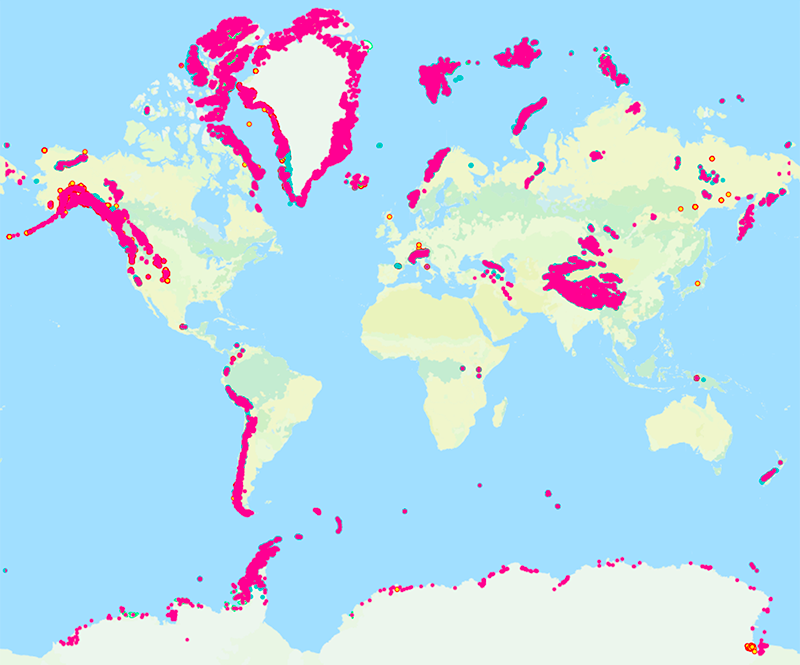
- 91% of the Glaciers are in Antarctica and 8% are in Greenland. They occupy about 10% of the world's total land area.
Significance:
- Glaciers as Reservoirs: About three-quarters of Earth's freshwater is stored in glaciers. Therefore, glacier ice is the second largest reservoir of water on Earth and the largest reservoir of freshwater on Earth.
- The cold runoff from glaciers also affects downstream water temperatures.
- Glaciers feeding Rivers: The Gangotri Glacier, one of the largest glaciers in the Himalayan Mountains, is the source of the Ganga River.
- The Ganges is the most important source of freshwater and electricity in India and Bangladesh.
- Glaciers for Aquatic Life: Many aquatic species in mountainous environments require cold water temperatures to survive which is provided by Glaciers.
- Some aquatic insects are especially sensitive to stream temperature and cannot survive without the cooling effects of glacial meltwater.
- Such changes in stream habitat may also adversely impact native trout and other keystone salmon species.
- Glaciers for People: Glaciers provide people with many useful resources. Glacial till provides fertile soil for growing crops.
- Deposits of sand and gravel are used to make concrete and asphalt.
Classification of Glaciers
- Glaciers can be classified according to their:
- Size (i.e. ice sheet, ice cap, valley glacier, cirque glacier)
- Thermal regime (polar vs. temperate).
Size Based
- Ice Cap: An ice cap is a dome-shaped glacier mass flowing in all directions, such as the ice cap on Ellesmere Island in the Canadian Arctic.
- There is still some uncertainty about the full volume of glaciers and ice caps on Earth, but if all of them were to melt, global sea level would rise approximately 70 meters (approximately 230 feet), flooding every coastal city on the planet.
- Valley Glaciers: Also called Alpine Glaciers or Mountain Glaciers, they form on mountainsides and move downward through valleys.
- They are found in high mountains of every continent except Australia (although there are many in New Zealand).
- Example: The Gorner Glacier in Switzerland and the Furtwangler Glacier in Tanzania.
- They are found in high mountains of every continent except Australia (although there are many in New Zealand).
- Ice Sheets: Unlike valley glaciers, ice sheets are not limited to mountainous areas. They form broad domes and spread out from their centers in all directions.
- As ice sheets spread, they cover everything around them with a thick blanket of ice, including valleys, plains, and even entire mountains.
- The largest ice sheets, called continental glaciers, spread over vast areas.
- Continental glaciers cover most of Antarctica and the island of Greenland.
- Cirque glaciers: They are short and wide, are confined to cirques, or amphitheatres, cut in the mountain landscape.
Thermal Regime based:
- Polar Glacier: A polar glacier is defined as one that is below the freezing temperature throughout its mass for the entire year.
- A subpolar glacier contains ice below the freezing temperature, except for surface melting in the summer and a basal layer of temperate ice.
- Temperate Glacier: A temperate glacier is the one that’s essentially at the melting point, so liquid water coexists with glacier ice.
- They are found in North America, South America, Europe, Africa, and Asia and New Zealand.
- Some of the Antarctic glaciers and Greenland’s southern outlet glaciers are temperate.
- They are found in North America, South America, Europe, Africa, and Asia and New Zealand.
Landforms Formed
Erosional Landforms
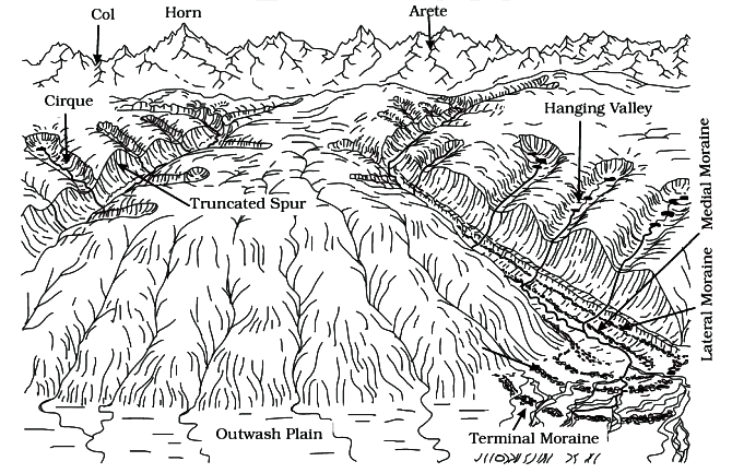
- Glacial Valleys/Troughs: These valleys are trough-like and U-shaped with broad floors and relatively smooth, and steep sides.
- The valleys may contain littered debris or debris shaped as moraines with swampy appearance.
- Very deep glacial troughs filled with sea water and making up shorelines (in high latitudes) are called fjords/fiords.
- Cirques: Often are found at the heads of glacial valleys, these are the most common of landforms in glaciated mountains.
- They are deep, long and wide troughs or basins with very steep concave to vertically dropping high walls at its head as well as sides.
- A lake of water can be seen quite often within the cirques after the glacier disappears. Such lakes are called cirque lakes or tarn lakes.
- Horns and Serrated: Ridges Horns form through headward erosion of the cirque walls.
- If three or more radiating glaciers cut headward until their cirques meet, high, sharp pointed and steep sided peaks called horns form.
Depositional Landforms:
- Glacial Till: The unassorted coarse and fine debris dropped by the melting glaciers is called glacial till.
- Some amount of rock debris small enough to be carried by such melt-water streams is washed down and deposited.
- Such glaciofluvial deposits are called outwash deposits.
- The outwash deposits are roughly stratified and assorted.
- Some amount of rock debris small enough to be carried by such melt-water streams is washed down and deposited.
- Moraines: They are long ridges of deposits of glacial till.
- Terminal moraines are long ridges of debris deposited at the end (toe) of the glaciers.
- Lateral moraines form along the sides parallel to the glacial valleys.
- Many valley glaciers retreating rapidly leave an irregular sheet of till over their valley floors called ground moraines.
- The moraine in the centre of the glacial valley flanked by lateral moraines is called medial moraine.
- They are imperfectly formed as compared to lateral moraines. Sometimes medial moraines are indistinguishable from ground moraines.
- Eskers: These are ridges made of sands and gravels, deposited by glacial meltwater flowing through tunnels within and underneath glaciers, or through meltwater channels on top of glaciers.
- Over time, the channel or tunnel gets filled up with sediments. As the ice retreats, the sediments are left behind as a ridge in the landscape.
- Drumlins: They are smooth oval shaped ridge-like features composed mainly of glacial till with some masses of gravel and sand.
- The long axes of drumlins are parallel to the direction of ice movement.
- They may measure up to 1 km in length and 30 m or so in height.
- The drumlin end facing the glacier is called the stoss end and is blunter and steeper than the other end called tail.