Geography
Uttarakhand Flash Flood
- 08 Feb 2021
- 7 min read
Why in News
Recently, a glacial break in the Tapovan-Reni area of Chamoli District of Uttarakhand led to massive Flash Flood in Dhauli Ganga and Alaknanda Rivers, damaging houses and the nearby Rishiganga power project.
- In June 2013, flash floods in Uttarakhand wiped out settlements and took lives.
Key Points
- Cause of Flash Flood in Uttarakhand:
- It occurred in river Rishi Ganga due to the falling of a portion of Nanda Devi glacier in the river which exponentially increased the volume of water.
- Rishiganga meets Dhauli Ganga near Raini. So Dhauli Ganga also got flooded.
- It occurred in river Rishi Ganga due to the falling of a portion of Nanda Devi glacier in the river which exponentially increased the volume of water.
- Major Power Projects Affected:
- Rishi Ganga Power Project:
- It is a privately owned 130MW project.
- Tapovan Vishnugad Hydropower Project on the Dhauliganga:
- It was a 520 MW run-of-river hydroelectric project being constructed on Dhauliganga River.
- Several other projects on the Alaknanda and Bhagirathi river basins in northwestern Uttarakhand have also been impacted by the flood.
- Rishi Ganga Power Project:
- Flash Floods:
- About:
- These are sudden surges in water levels generally during or following an intense spell of rain.
- These are highly localised events of short duration with a very high peak and usually have less than six hours between the occurrence of the rainfall and peak flood.
- The flood situation worsens in the presence of choked drainage lines or encroachments obstructing the natural flow of water.
- Causes:
- It may be caused by heavy rain associated with a severe thunderstorm, hurricane, tropical storm, or meltwater from ice or snow flowing over ice sheets or snowfields.
- Flash Floods can also occur due to Dam or Levee Breaks, and/or Mudslides (Debris Flow).
- In areas on or near volcanoes, flash floods have also occurred after eruptions, when glaciers have been melted by the intense heat.
- The intensity of the rainfall, the location and distribution of the rainfall, the land use and topography, vegetation types and growth/density, soil type, and soil water- content all determine just how quickly the Flash Flooding may occur, and influence where it may occur.
- About:
Glaciers
- About:
- Glaciers are a bulk of ice moving under its weight. It forms in areas where the amassing of snow goes beyond its ablation over many years.
- They are generally seen in the snow-fields.
- This largest freshwater basin covers around 10% of the land surface of the Earth.
- According to the topography and the location of the glacier, it can be categorized as Mountain Glacier (Alpine Glaciers) or Continental Glacier (Ice Sheets).
- The Continental Glacier moves outward in all directions whereas the Mountain Glacier moves from a higher to a lower altitude.
- Glaciers and Floods:
- Glacial Lakes:
- Retreating glaciers, like several in the Himalayas, usually result in the formation of lakes at their tips, called proglacial lakes, often bound only by sediments and boulders.
- Flood:
- If the boundaries of these lakes are breached, it can lead to large amounts of water rushing down to nearby streams and rivers, gathering momentum on the way by picking up sediments, rocks and other material, and resulting in flooding downstream.
- Glacial Lakes:
- Impact of Climate Change:
- Climate change has driven erratic weather patterns like increased snowfall and rainfall, warmer winters has led to the melting of a lot of snow.
- According to the latest assessment reports of the UN Intergovernmental Panel on Climate Change, glacier retreat and permafrost thaw are projected to decrease the stability of mountain slopes and increase the number and area of glacier lakes.
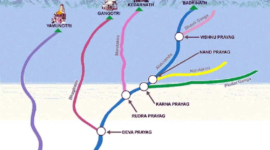
Dhauliganga
- Origination:
- It originates from Vasudhara Tal, perhaps the largest glacial lake in Uttarakhand.
- About:
- Dhauliganga is one of the important tributaries of Alaknanda, the other being the Nandakini, Pindar, Mandakini and Bhagirathi.
- Dhauliganga is joined by the Rishiganga river at Raini.
- It merges with the Alaknanda at Vishnuprayag.
- There it loses its identity and the Alaknanda flows southwest through Chamoli, Maithana, Nandaprayag, Karnaprayag until it meets the Mandakini river, coming from the north at Rudraprayag.
- After subsuming Mandakini, the Alaknanda carries on past Srinagar, before joining the Ganga at Devprayag.
- Alaknanda then disappears and the mighty Ganga carries on its journey, first flowing south then west through important pilgrimage centres such as Rishikesh and finally descending into the Indo-Gangetic plains at Haridwar.
- Dhauliganga is one of the important tributaries of Alaknanda, the other being the Nandakini, Pindar, Mandakini and Bhagirathi.
Nanda Devi National Park
- Location:
- It is situated around the peak of Nanda Devi (7816 m) in the state of Uttarakhand in northern India.
- About:
- The park encompasses the Nanda Devi Sanctuary, a glacial basin surrounded by a ring of peaks, and drained by the Rishi Ganga through the Rishi Ganga Gorge.
- Established:
- The Park was established as Sanjay Gandhi National Park by Notification in 1982 but was later renamed Nanda Devi National Park.
- It was inscribed a World Heritage Site by the United Nations Educational, Scientific and Cultural Organization (UNESCO) in 1988.
- Flora:
- Some 312 floral species that include 17 rare species have been found here. Fir, birch, rhododendron, and juniper are the main flora.
- Fauna:
- Himalayan black bear, Snow leopard , Himalayan Musk Deer etc.


