Geography
Mapping Seismic Hazard of Eastern Himalaya
- 09 Feb 2021
- 5 min read
Why in News
Recently, scientists have found the first geological evidence of an earthquake on the border of Assam and Arunachal Pradesh, documented as the Sadiya earthquake in history. This finding could contribute to a seismic hazard map of the eastern Himalaya, which can facilitate construction and planning in the region.
- This site is near the Tuting-Tidding Suture Zone- a major part of the Eastern Himalaya, where the Himalaya takes a sharp southward bend and connects with the Indo-Burma Range.
Key Points
- About:
- Scientists from Wadia Institute of Himalayan Geology (WIHG) carried out a mega trench excavation at Himebasti village, Arunachal Pradesh where the most recent event records the imprints of the 1697 Sadiya earthquake and analysed it with modern geological techniques.
- WIHG is an autonomous institute under the Department of Science and Technology (DST), Government of India.
- Scientists found large tree trunks embedded in the youngest flood deposits at the exit of the Subansiri River (Sadiya town is located roughly 145 km southeast of Subansiri river), suggesting the post-seismic aggradation of the river following an array of aftershocks till six months.
- Aggradation is the term used in geology for the increase in land elevation due to deposition of sediment.
- Aftershocks are earthquakes that follow the largest shock of an earthquake sequence. They are smaller than the mainshock and within 1-2 rupture lengths distance from the mainshock.
- Scientists from Wadia Institute of Himalayan Geology (WIHG) carried out a mega trench excavation at Himebasti village, Arunachal Pradesh where the most recent event records the imprints of the 1697 Sadiya earthquake and analysed it with modern geological techniques.
- Significance:
- Studying the past earthquakes help to determine the seismic potential of the region. This helps in mapping the earthquake hazard of the region and enables syncing the development activities accordingly.
- Arunachal Pradesh, being near the Indo-China Border, and sometimes centre of dispute regarding its ownership, is strategically important.
- A number of development initiatives like constructing roads, bridges and hydropower projects are being undertaken, therefore there is an urgent need for understanding the pattern of seismicity in this region.
- Seismic Hazard Map of India:
- India is one of the highly earthquake affected countries because of the presence of tectonically active young fold mountains, Himalayas.
- India has been divided into four seismic zones (II, III, IV, and V) based on scientific inputs relating to seismicity, earthquakes occurred in the past and tectonic setup of the region.
- Previously, earthquake zones were divided into five zones with respect to the severity of the earthquakes but the Bureau of Indian Standards (BIS) grouped the country into four seismic zones by unifying the first two zones.
- BIS is the official agency for publishing the seismic hazard maps and codes.
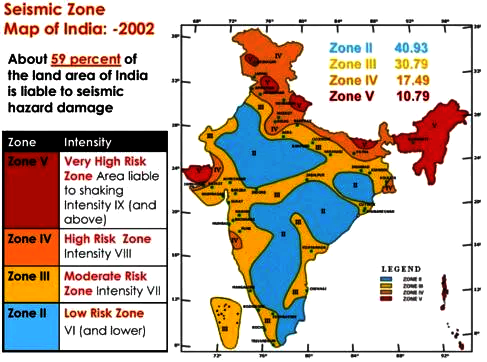
- Seismic Zone II:
- Area with minor damage earthquakes corresponding to intensities V to VI of MM scale (MM-Modified Mercalli Intensity scale).
- Seismic Zone III:
- Moderate damage corresponding to intensity VII of MM scale.
- Seismic Zone IV:
- Major damage corresponding to intensity VII and higher of MM scale.
- Seismic Zone V:
- Area determined by pro seismically of certain major fault systems and is seismically the most active region.
- Earthquake zone V is the most vulnerable to earthquakes, where historically some of the country’s most powerful shocks have occurred.
- Earthquakes with magnitudes in excess of 7.0 have occured in these areas, and have had intensities higher than IX.
- Seismic Waves, Richter Scale and Mercalli scale:
- Seismic waves are the vibrations from earthquakes that travel through the Earth and are recorded on instruments called seismographs.
- Seismographs record a zigzag trace that shows the varying amplitude of ground oscillations beneath the instrument.
- The earthquake events are scaled either according to the magnitude or intensity of the shock.
- The magnitude scale is known as the Richter scale. The magnitude relates to the energy released during the earthquake which is expressed in absolute numbers, 0-10.
- The intensity scale or Mercalli scale takes into account the visible damage caused by the event. The range of intensity scale is from 1-12.
- Seismic waves are the vibrations from earthquakes that travel through the Earth and are recorded on instruments called seismographs.


