Geography
Earthquake
- 26 Nov 2021
- 4 min read
Why in News
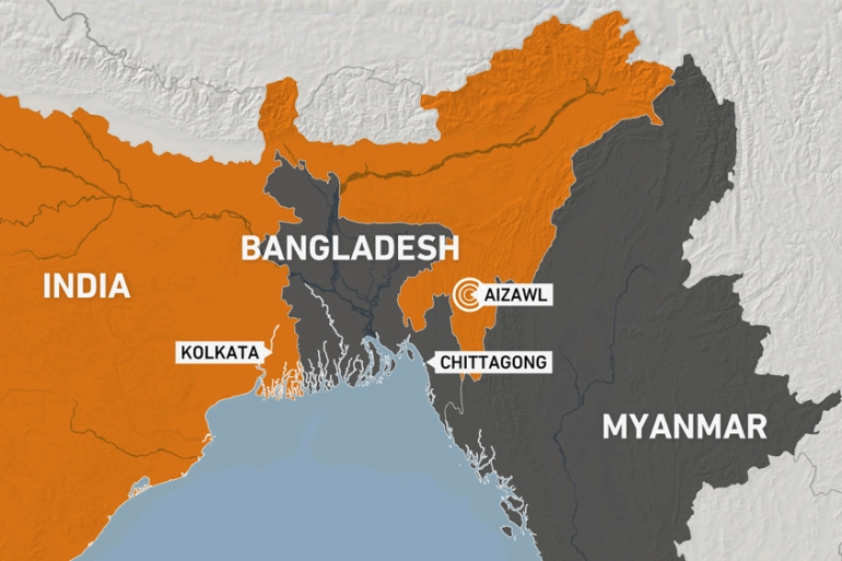
Recently, a shallow and strong earthquake of magnitude 6.1 struck the Myanmar-India border region early.
Key Points
- Earthquake:
- An earthquake in simple words is the shaking of the earth. It is a natural event. It is caused due to release of energy, which generates waves that travel in all directions.
- The vibrations called seismic waves are generated from earthquakes that travel through the Earth and are recorded on instruments called seismographs.
- The location below the earth’s surface where the earthquake starts is called the hypocenter, and the location directly above it on the surface of the earth is called the epicenter.
- Types of Earthquake: Fault Zones, Tectonic Earthquakes, Volcanic Earthquake, Human Induced Earthquakes.
- Distribution of Earthquake:
- The world's greatest earthquake belt, the circum-Pacific seismic belt, is found along the rim of the Pacific Ocean, where about 81% of our planet's largest earthquakes occur. It has earned the nickname "Ring of Fire".
- The belt exists along boundaries of tectonic plates, where plates of mostly oceanic crust are sinking (or subducting) beneath another plate. Earthquakes in these subduction zones are caused by slip between plates and rupture within plates.
- The Alpide earthquake belt (mid Continental belt) extends from Java to Sumatra through the Himalayas, the Mediterranean, and out into the Atlantic.
- This belt accounts for about 17% of the world's largest earthquakes, including some of the most destructive.
- The third prominent belt follows the submerged mid-Atlantic Ridge. The ridge marks where two tectonic plates are spreading apart (a divergent plate boundary).
- Most of the mid-Atlantic Ridge is deep underwater and far from human development.
- The world's greatest earthquake belt, the circum-Pacific seismic belt, is found along the rim of the Pacific Ocean, where about 81% of our planet's largest earthquakes occur. It has earned the nickname "Ring of Fire".
Seismic Hazard Map of India
- India is one of the highly earthquake affected countries because of the presence of technically active young fold mountains - Himalaya.
- India has been divided into four seismic zones (II, III, IV, and V) based on scientific inputs relating to seismicity, earthquakes that occurred in the past and tectonic setup of the region.
- Previously, earthquake zones were divided into five zones with respect to the severity of the earthquakes but the Bureau of Indian Standards (BIS) grouped the country into four seismic zones by unifying the first two zones.
- BIS is the official agency for publishing the seismic hazard maps and codes.
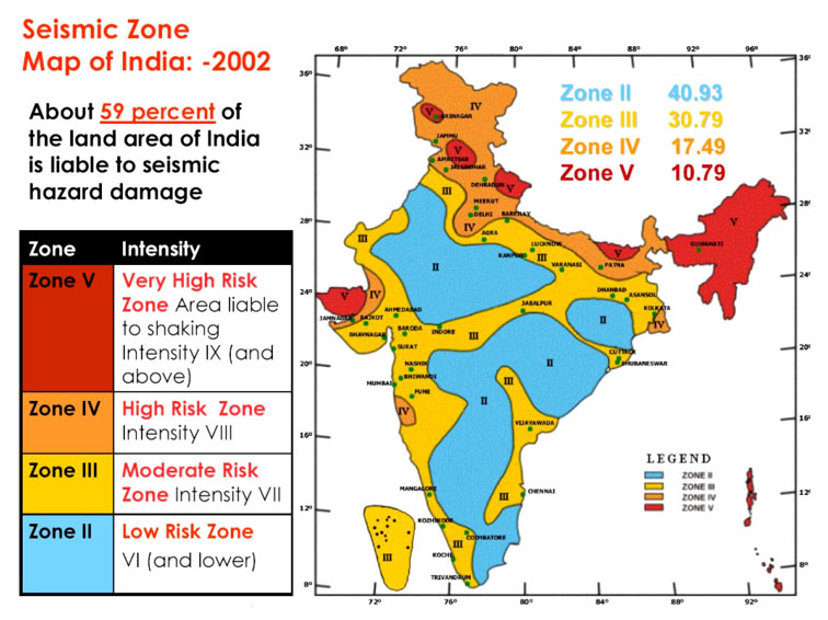
- Seismic Zone II:
- Area with minor damage earthquakes corresponding to intensities V to VI of MM scale (MM-Modified Mercalli Intensity scale).
- Seismic Zone III:
- Moderate damage corresponding to intensity VII of MM scale.
- Seismic Zone IV:
- Major damage corresponding to intensity VII and higher of MM scale.
- Seismic Zone V:
- Area determined by pro seismically of certain major fault systems and is seismically the most active region.
- Earthquake zone V is the most vulnerable to earthquakes, where historically some of the country’s most powerful shocks have occurred.
- Earthquakes with magnitudes in excess of 7.0 have occured in these areas, and have had intensities higher than IX.


