Biodiversity & Environment
Ken-Betwa Inter-Linking Project
- 10 Dec 2021
- 6 min read
Why in News
Recently, the Union Cabinet has approved the funding and implementation of Ken-Betwa inter-linking of rivers project.
- The project envisages transferring water from the Ken river to the Betwa river, both tributaries of the Yamuna. The project will be completed in eight years.
Key Points
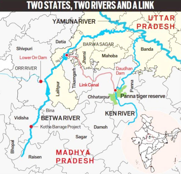
- About: It is the first project under the National Perspective Plan for interlinking of rivers. The Ken-Betwa Link Canal will be 221 km long, including a 2-km long tunnel.
Ken and Betwa Rivers
- Ken and Betwa rivers originate in MP and are the tributaries of Yamuna.
- Ken meets with Yamuna in Banda district of UP and with Betwa in Hamirpur district of UP.
- Rajghat, Paricha and Matatila dams are over Betwa river.
- Ken River passes through Panna tiger reserve.
- Background: The idea of linking Ken with Betwa got a major push in August 2005, when a tripartite memorandum of understanding for preparation of a Detailed Project Report (DPR) was signed among the Centre and governments of Madhya Pradesh and Uttar Pradesh.
- In 2008, the Centre declared KBLP a National Project. Later, it was included as part of the Prime Minister’s package for development of drought-prone Bundelkhand region.
- In 2021, a memorandum of agreement was signed for implementation of this project among the Ministry of Jal Shakti and the two states.
- Implementing Agency:
- A Special Purpose Vehicle (SPV) called Ken-Betwa Link Project Authority (KBLPA) will be set up to implement the project.
- The National Interlinking of Rivers Authority (NIRA) has the powers to set up SPV for individual link projects.
- Phases of the Project: The project has two phases, with mainly four components.
- Phase-I will involve one of the components — Daudhan Dam complex and its subsidiary units such as Low Level Tunnel, High Level Tunnel, Ken-Betwa Link Canal and power houses.
- Phase-II will involve three components — Lower Orr Dam, Bina Complex Project and Kotha Barrage.
- Benefits: The project lies in Bundelkhand, a drought-prone region, which spreads across 13 districts of Uttar Pradesh and Madhya Pradesh.
- According to the Jal Shakti Ministry, the project will be of immense benefit to this water-starved region.
- Further, it will pave the way for more interlinking of river projects to ensure that scarcity of water does not become an inhibitor for development in the country.
- According to the Jal Shakti Ministry, the project is expected to provide annual irrigation of 10.62 lakh hectares, supply drinking water to about 62 lakh people, and generate 103 MW of hydropower and 27 MW of solar power.
- Associated Challenges:
- Submergence of Panna Tiger Reserve: According to the National Water Development Agency, the reservoir of Daudhan dam will involve “a submergence of 9000 ha area, out of which 5803 ha comes under Panna Tiger Reserve (PTR).
- To mitigate this, three WildLife Sanctuaries (WLS), viz Nauradehi, Rani Durgawati of MP and Ranipur WLS of UP are planned to be integrated with PTR.
- Several Clearances Required: Various types of clearances are required, such as:
- Techno-economic clearance: To be given by the Central Water Commission;
- Forest clearance and environmental clearance: To be given Ministry of Environment, Forests & Climate Change
- Resettlement and rehabilitation plan of tribal population: to be given by the Ministry of Tribal Affairs.
- Submergence of Panna Tiger Reserve: According to the National Water Development Agency, the reservoir of Daudhan dam will involve “a submergence of 9000 ha area, out of which 5803 ha comes under Panna Tiger Reserve (PTR).
History of Interlinking of Rivers in India
- Colonial Idea:
- The idea was first mooted during the British Raj when Sir Arthur Cotton, a British general and irrigation engineer suggested linking the Ganga and the Cauvery for navigational purposes.
- Projects undertaken by the British:
- In the past, several river linking projects have been taken up. For instance, the Periyar Project, under which transfer of water from Periyar basin to Vaigai basin was envisaged, was commissioned in 1895.
- Other projects such as Parambikulam Aliyar, Kurnool Cuddapah Canal, Telugu Ganga Project, and Ravi-Beas-Sutlej too were undertaken.
- In the past, several river linking projects have been taken up. For instance, the Periyar Project, under which transfer of water from Periyar basin to Vaigai basin was envisaged, was commissioned in 1895.
- National water Grid:
- In the 1970s, the idea of transferring surplus water from a river to a water-deficit area was mooted by the then Union Irrigation Minister Dr K L Rao.
- He suggested construction of a National Water Grid for transferring water from water-rich areas to water-deficit areas.
- Garland Canal:
- Later, Captain Dinshaw J Dastoor proposed a Garland Canal to redistribute the water from one area to another. However, the government did not pursue these two ideas further.
- National Perspective Plan:
- It was not until August 1980 that the Ministry of Irrigation prepared a National Perspective Plan for water resources development envisaging inter-basin water transfer.
- The NPP comprised two components: Himalayan Rivers Development, and Peninsular Rivers Development.
- Based on the NPP, the National Water Development Agency (NWDA) identified 30 river links– 16 under the Peninsular component and 14 under Himalayan Component.
- The Ken-Betwa Link Project is one of the 16 projects under the peninsular component.


