81 Solved Questions with Answers
-
2025
How are climate change and the sea level rise affecting the very existence of many island nations ? Discuss with examples. (Answer in 150 words)
Approach
- Introduction: Provide an overview of how climate change and sea level rise are impacting island nations globally.
- Body: Discuss the specific consequences faced by island nations due to rising sea levels, including examples and the social, economic, and environmental impacts.
- Conclusion: Conclude with the urgency of international cooperation and climate action to address the existential threat posed to island nations.
Introduction
Since the late 19th century, global sea levels have risen by approximately 21–24 cm, with the rate accelerating in recent decades. This rise is primarily due to the melting of glaciers and ice sheets and the thermal expansion of seawater caused by rising temperatures. This rapid rise in sea levels is threatening the very existence of many island nations.
Body:
Sea Level Rise Affecting the Very Existence of Island Nations:
Submersion of Land and Loss of Habitats:
- Many island nations are composed of small, low-lying atolls, which are highly vulnerable to rising seas.
- The Maldives has an average ground level of just 1.5 meters above sea level, making it one of the most threatened countries in the world.
- As sea levels rise, entire islands are at risk of submersion, resulting in the displacement of populations.
- Similarly, Kiribati, another low-lying Pacific island nation, has been experiencing rising saltwater encroachment into freshwater sources and arable land.
- This not only affects drinking water but also disrupts agriculture, which is crucial for food security. The government of Kiribati has had to explore options for relocation.
Economic Impacts on Livelihood:
- Island nations heavily rely on industries like fishing and tourism, both of which are threatened by climate change.
- For example, the Marshall Islands and Tuvalu are witnessing the degradation of coral reefs due to rising sea temperatures.
- Coral reefs also act as natural barriers against storm surges, and their destruction leaves coastal communities more vulnerable to tsunamis and tropical storms.
- Tourism is also being threatened by the rising sea levels and environmental degradation. The Maldives, known for its pristine beaches and luxury resorts, faces increasing challenges from beach erosion, flooding, and damage to infrastructure.
Cultural and Social Implications:
- The displacement caused by rising sea levels threatens the very existence of these cultures.
- The people of Vanuatu have already experienced the relocation of communities due to flooding.
- In the Solomon Islands, several villages have already been relocated due to rising sea levels, and there are fears that these migrations will lead to loss of identity, as communities struggle to preserve their traditions and way of life in new locations.
Increased Vulnerability to Natural Disasters:
- Island nations are often located in areas highly prone to natural disasters, such as cyclones, hurricanes, and tsunamis.
- With climate change, the intensity and frequency of these storms are increasing, further threatening these fragile ecosystems and their inhabitants.
- The Philippines and Fiji have experienced more intense cyclones in recent years, which have caused widespread destruction.
In response to these challenges, adaptation strategies such as:
- Strengthening coastal defenses, improving water management, and implementing technological solutions are critical.
- Global efforts to mitigate climate change, including reducing greenhouse gas emissions and shifting to renewable energy sources, are essential to prevent further exacerbation of this crisis.
Conclusion
Global cooperation is crucial to protect these nations and ensure their resilience against the impacts of climate change. The Paris Agreement of 2015 was a step forward, but island nations continue to call for greater financial support for adaptation and mitigation strategies.
-
2025
What are non-farm primary activities? How are these activities related to physiographic features in India ? Discuss with suitable examples. (Answer in 150 words)
Approach:
- Introduction: Define non-farm primary activities and highlight their importance in the economy.
- Body: Discuss how these activities are influenced by India's diverse physiographic features, with specific examples from different regions.
- Conclusion: Conclude by emphasizing the strong relationship between non-farm primary activities and India’s varied geographical landscape.
Introduction:
Non-farm primary activities involve the extraction of natural resources without crop cultivation, including fishing, mining, forestry, and animal husbandry. India’s diverse physiography ranging from mountains and plains to coasts and plateaus, significantly influences the type and distribution of these activities across the country.
Body:
Non-Farm Primary Activities and their Relationship with Physiographic Features in India:
Fishing: Coastal and Inland Water Bodies
- Coastal Areas: In coastal regions where the presence of seas and oceans provides rich marine resources, fishing is one of the non-farm primary activities. States like Kerala, West Bengal, Tamil Nadu, and Andhra Pradesh benefit from their extensive coastlines, making marine fishing a vital economic activity.
- The Sundarbans mangrove forest in West Bengal is renowned for aquaculture and fishing.
- The Konkan Coast (Maharashtra and Goa) is known for its fishing industry, where traditional methods like trawl fishing and seaweed farming are prevalent.
- Inland Water Bodies: Rivers and lakes also support freshwater fishing.
- For example, Kerala is also known for backwater fishing, and the Madhya Pradesh regions engage in river-based fishing.
Forestry: Rich Forest Resources in Hills
- Himalayan and Mountainous Regions: The Himalayas are rich in forest resources, providing timber, medicinal plants, and firewood.
- Uttarakhand, Himachal Pradesh, J&K and Northeastern India are famous for forestry activities, including silviculture (forest management and cultivation), and the collection of herbal plants.
- The Western Ghats are rich in biodiversity and forests, with Karnataka, Kerala, and Tamil Nadu benefiting from activities like rubber production, spices, and bamboo harvesting.
Mining: Mineral Rich Areas
- Chotanagpur Plateau: One of India’s primary mining hubs, rich in minerals such as coal, iron ore, bauxite, and mica. States like Jharkhand, Odisha, Bihar, and Chhattisgarh have substantial mining operations due to the presence of rich deposits of minerals.
- Example: The Dhanbad region in Jharkhand is one of the largest coal mining areas in India.
- Deccan Plateau: The Deccan Plateau is also known for its rich bauxite and limestone deposits, particularly in Maharashtra, Karnataka, and Andhra Pradesh.
Animal Husbandry: Grazing Lands in Arid and Semi-Arid Regions
- Desert and Semi-Arid Regions: Animal husbandry is an essential non-farm activity in areas with large stretches of pastureland.
- The deserts of Rajasthan and Gujarat, with their extensive grazing lands, are known for camel rearing, sheep farming, and cattle rearing.
- Hilly Areas: The Himalayan foothills are suitable for yak farming and sheep rearing due to the terrain and climate, providing wool, milk, and meat.
Conclusion
From fishing along coastal regions to mining in plateau areas, and animal husbandry in arid regions, India’s physical landscape has shaped the evolution and success of these non-agricultural primary activities. Understanding this relationship is crucial for regional development and resource management strategies.
-
2025
Explain briefly the ecological and economic benefits of solar energy generation in India with suitable examples. (Answer in 150 words) 10
Approach:
- Introduction: Introduce solar energy as a key component of India's renewable energy strategy.
- Body: Discuss the ecological benefits, including reduced emissions, water conservation, and improved air quality, with relevant examples.
- Explain the economic benefits, such as job creation, cost-effectiveness, and income diversification, while connecting them to national energy security and sustainable growth.
- Conclusion: Conclude accordingly.
Introduction
Solar energy, a key pillar of India’s renewable energy transition, contributes significantly to ecological sustainability and economic development. It aligns with India’s commitments under the Paris Agreement and SDG-7 (Affordable and Clean Energy), promoting Justice, Sustainability, and Fraternity in development.
Body
Ecological Benefits of Solar Energy
1. Reduction in Carbon Emissions: Solar power emits approximately 20 times less CO2 than coal-based power (IPCC).
- E.g., India’s solar capacity avoided over 60 million tonnes of CO2 in 2023.
2. Conservation of Water Resources: Solar PV requires minimal water compared to thermal plants and supports SDG-6 (Clean Water and Sanitation).
3. Decentralised Clean Energy: Solar microgrids reduce dependence on fossil fuels in rural areas (e.g., Sunderbans).
- Promotes environmental justice for marginalised communities.
4. Improved Air Quality: Reduces pollutants like SO2 and NOx from thermal plants, aiding public health.
- Example: Delhi’s Indraprastha Gas Ltd. replaced diesel gensets with rooftop solar.
5. Land Optimization through Agrivoltaics: Dual land use-crop growth under solar panels (e.g., Delhi’s Agriculture-cum-Solar Farm Scheme).
Economic Benefits of Solar Energy
- Employment Generation: The solar PV sector in India employed about 318,600 people in both on-grid and off-grid systems (IRENA 2024).
- By 2030 Target: India can create 3.4 million jobs by achieving 500 GW non-fossil fuel capacity by 2030 (CEEW).
- Cost-effectiveness & Energy Security: India's solar costs drop 95% (2010-2024), paving the way for affordable, round-the-clock clean energy.
- India being 3rd-largest oil importer can reduce its import dependence for fossil fuels.
- Income Diversification for Farmers: PM-KUSUM and PM Surya Ghar-Muft Bijli Yojana enables farmers and householders to earn from selling surplus power to the grid.
- Boost to Manufacturing & Exports: PLI Scheme for solar PV modules to boost domestic industry.
- India aims for 280 GW solar capacity by 2030.
- Support for MSMEs and Urban Poor: Rooftop solar reduces operational cost for MSMEs and lowers electricity bills.
Conclusion
Solar energy in India exemplifies the synergy of environmental sustainability and inclusive economic growth. By promoting clean energy, it helps achieve climate justice and ensures energy access for all, in line with Sustainable Development Goals and the Preamble’s vision of justice and equality. Effective implementation of solar missions can transform India into a global green energy leader.
-
2025
What are Tsunamis? How and where are they formed? What are their consequences? Explain with examples. (Answer in 150 words) 10
Approach:
- Introduction: Introduce tsunamis with definition and defining term.
- Body: Explain the different causes of tsunamis (which form tsunamis) with relevant examples, and discuss its consequences.
- Conclusion: Conclude suitably.
Introduction:
Tsunamis are large, powerful sea waves caused by the sudden displacement of water, usually due to undersea earthquakes. Derived from the Japanese words tsu (harbour) and nami (wave), tsunamis pose significant threats to coastal ecosystems, infrastructure, and human lives, particularly in tectonically active regions.
Body:
Formation of Tsunamis
- Undersea Earthquakes: Sudden vertical displacement along subduction zones.
- E.g., 2004 Indian Ocean tsunami caused by a 9.1 magnitude quake near Sumatra.
- Volcanic Eruptions: Submarine or coastal volcanic activity displaces water.
- E.g., The Tonga Hunga-Hunga Ha'apai volcanic eruption in 2022, caused a global tsunami.
- Landslides (Submarine or Coastal): Collapse of land into the ocean.
- E.g., Lituya Bay tsunami, Alaska (1958).
- Glacial Calving or Meteoritic Impact: Rare, but large-scale ice collapses or cosmic impacts can displace water.
- Example: The Chicxulub impact (66 million years ago) is believed to have triggered tsunamis that contributed to the extinction of the dinosaurs.
- Underwater Nuclear Blast: Nuclear explosions beneath the ocean’s surface can displace large volumes of water and cause significant tsunami waves.
Consequences of Tsunamis
- Human Casualties: Tsunamis can lead to massive loss of life due to the overwhelming force of the waves.
- Example: The 2004 Indian Ocean tsunami claimed over 230,000 lives across several countries.
- Economic Loss: Tsunamis cause severe damage to infrastructure, homes, agriculture, and industries like fisheries.
- Example: The 2011 Tohoku tsunami in Japan resulted in loss of billions of dollars and human capital as well.
- Environmental Impact: Coastal habitats like mangroves, coral reefs, and marshlands can be destroyed, leading to long-term ecological damage.
- Saltwater intrusion into freshwater sources can also disrupt local ecosystems.
- Health and Sanitation Crisis: The destruction of infrastructure can lead to waterborne diseases, lack of medical care, and poor sanitation.
- Example: After the 2004 tsunami, cholera outbreaks were reported in affected regions.
- The 2004 tsunami increased household out-of-pocket health expenses by 35% in heavy damage areas in the short run.
- Example: After the 2004 tsunami, cholera outbreaks were reported in affected regions.
- Psychological and Social Trauma: Tsunami survivors often face long-term mental health issues, including post-traumatic stress disorder (PTSD).
- Loss of cultural landmarks and displacement of communities add to the psychological impact.
Conclusion
Climate change and rising sea levels have increased vulnerability to tsunamis. Strengthening early warning systems (such as the INCOIS Tsunami Warning Centre), promoting coastal resilience, and enhancing community preparedness are crucial for mitigating their impact - aligning with SDG 13: Climate Action and SDG 11: Sustainable Cities and Communities.
-
2025
Give a geographical explanation of the distribution of off-shore oil reserves of the world. How are they different from the on-shore occurrences of oil reserves? (Answer in 250 words) 15
Approach:
- Give a short introduction on oil reserves and their global significance.
- Explain the geographical distribution of offshore reserves with examples.
- Compare offshore vs onshore oil reserves with clear distinctions.
- Conclude with a balanced statement on their relevance.
Introduction
Petroleum resources are unevenly distributed across the globe, concentrated mainly in sedimentary basins formed under marine conditions. With technological advancements, off-shore oil reserves-deposits located beneath continental shelves and shallow seas-have become a major contributor to global supply, a significant proportion of the world's heavy oil reserves. Their distribution and occurrence differ significantly from on-shore reserves, shaping energy geopolitics.
Body
Geographical Distribution of Offshore Oil Reserves
- Middle East & Persian Gulf: Offshore fields in Saudi Arabia (Safaniya), Iran, Qatar, and UAE dominate global supply with low-cost, shallow-water reserves.
- North Sea Basin (Europe): Offshore reserves in the UK and Norway (e.g., Brent field) have been vital for European energy since the 1970s.
- West Africa (Atlantic Margin): Countries like Nigeria and Angola possess deep-water reserves yielding high-quality sweet crude, mainly for export.
- Latin America: Brazil’s Santos and Campos pre-salt basins are among the world’s largest deep-water reserves, while Venezuela’s Orinoco delta adds further strength.
- North America: The Gulf of Mexico (USA, Mexico) produces significant offshore oil with advanced deep-water technology.
- Russia & Arctic: Caspian Sea (Kashagan) and Sakhalin Basin reserves are major, though Arctic offshore exploration faces technical and ecological challenges.
- Asia-Pacific: Offshore reserves in the South China Sea, East China Sea, and Indian basins (Mumbai High, KG-D6) contribute strategically to regional energy security.
Differences between Offshore and Onshore Oil Reserves
Aspect
Offshore Oil Reserves
Onshore Oil Reserves
Geological Location
Found in continental shelves and seabeds beneath shallow or deep seas.
Found in terrestrial sedimentary basins on land.
Extraction Techniques
Require drilling rigs, subsea pipelines, floating platforms due to marine conditions.
Use conventional rigs, surface wells, and secondary recovery methods.
Cost & Technology
High-cost and technologically intensive, involving seismic surveys and deep-sea drilling.
Relatively cheaper and simpler, though mature basins need enhanced recovery.
Global Production Share
Contribute around 30% of global output (IEA, 2022).
Dominate with nearly 70% of total output.
Risks & Environment
Risk of oil spills, marine damage, and storm disruptions (e.g., Deepwater Horizon, 2010).
Risks include land degradation, groundwater contamination, and community displacement.
Geopolitical Dimensions
Often located in disputed maritime zones (South China Sea, Eastern Mediterranean).
Largely within national borders, making governance easier.
Conclusion
The geography of offshore oil reserves shows their concentration in continental margins and tectonic shelves, from the Persian Gulf to Brazil, the Gulf of Mexico, and the North Sea. Offshore reserves differ from onshore in location, technology, costs, risks, and geopolitical sensitivity, but both remain vital for global energy security. With onshore reserves maturing, the future of oil increasingly depends on offshore exploration, balanced with sustainability and environmental safeguards.
-
2025
How can Artificial Intelligence (AI) and drones be effectively used along with GIS and RS techniques in locational and aerial planning? (Answer in 250 words) 15
Approach:
- Briefly introduce the role of AI, drones, GIS, and Remote Sensing (RS) in planning.
- Explain their effective applications in locational planning and aerial planning with examples.
- Highlight the emerging role of GeoAI as the integration of these tools.
- Conclude with their significance for sustainable and inclusive planning.
Introduction
The integration of Artificial Intelligence (AI), drones, Geographic Information Systems (GIS), and Remote Sensing (RS) is transforming modern planning processes. Together, they constitute Geospatial Artificial Intelligence (GeoAI), which enhances data acquisition, analysis, and decision-making for locational and aerial planning. From urban development to agriculture and disaster management, their applications are increasingly shaping evidence-based and sustainable planning in India and worldwide.
Body
Applications in Locational Planning
- Urban Infrastructure: AI-enabled GIS helps optimize land-use allocation, transport corridors, and public utilities for efficient cities.
- For instance, Delhi Master Plan 2041 uses GIS datasets for zoning and expansion planning.
- Agriculture and Land Use: RS imagery analyzed through AI and drones supports precision farming, soil mapping, and irrigation planning, enhancing productivity.
- India’s Digital Agriculture Mission (2021–25) promotes AI- and drone-driven monitoring.
- Industrial and Economic Planning: AI integrated with GIS assists in identifying industrial clusters, logistics hubs, and SEZs by analyzing terrain, resource distribution, and accessibility.
- The Delhi–Mumbai Industrial Corridor (DMIC) uses GIS-based locational modelling.
- Public Services: Machine learning applied to geospatial data optimizes the location of schools, hospitals, and emergency services, improving equitable access in rural and urban areas.
Applications in Aerial Planning
- Disaster Management: AI-driven drones combined with RS provide real-time monitoring of floods, cyclones, and earthquakes.
- During the 2018 Kerala floods, drones mapped inundated areas to guide relief operations.
- Environmental Monitoring: GIS-RS with drones track deforestation, wetland loss, and coastal erosion, while AI predicts long-term impacts.
- The National Wetland Atlas demonstrates RS-GIS integration for conservation.
- Transport and Connectivity: Aerial surveys via drones and AI enhance route alignment of highways, railways, and metro corridors, reducing ecological disruption.
- The Bharatmala Pariyojana employs such geospatial planning.
- Smart Cities: Drones generate 3D models of urban areas, integrated with AI and GIS for planning utilities, drainage, and energy systems under India’s Smart Cities Mission.
- Defense and Security: AI-enabled drones and RS strengthen border surveillance and terrain analysis, supporting strategic planning in sensitive zones like Ladakh and Northeast India.
Emerging Role of GeoAI
- GeoAI combines AI with GIS and RS to enable spatial representation learning, knowledge-guided models, and predictive analytics.
- It enhances pattern recognition in satellite imagery, aids in urban computing, and improves Earth system science modelling.
- Challenges include ensuring fairness, privacy, and explainability in GeoAI applications, highlighting the need for ethical frameworks in India’s digital governance.
Conclusion
AI, drones, GIS, and RS-together under GeoAI frameworks-are revolutionizing locational and aerial planning by providing real-time, accurate, and predictive insights. For India, their integration in agriculture, smart cities, disaster management, and infrastructure planning will ensure inclusive growth, resilience, and sustainability. As technology advances, combining GeoAI with ethical safeguards will be key to maximizing its developmental potential.
-
2025
Discuss how the changes in shape and sizes of continents and ocean basins of the planet take place due to tectonic movements of the crustal masses. 15 (Answer in 250 words)
Approach:
- Introduce tectonic movements and their role in shaping continents and ocean basins.
- Explain Alfred Wegener’s continental drift theory and its evolution into modern plate tectonics.
- Discuss how plate divergence (e.g., ocean basin expansion) and convergence (e.g., mountain formation) occur.
- Conclude with the impact of tectonic movements on Earth's surface and their link to natural disasters.
Introduction:
Tectonic movements of Earth's crustal masses play a significant role in shaping the planet’s surface, particularly in the formation and alteration of continents and ocean basins. These movements occur due to the activity of tectonic plates, which shift due to forces such as mantle convection, slab pull, and ridge push. The interaction between these plates leads to the rearrangement of landmasses and ocean floors, resulting in phenomena like continental drift, mountain formation, and ocean basin expansion or contraction.
Body:
Continental Drift Theory and Its Evolution:
- The concept of continental drift was first proposed by Alfred Wegener in 1912, suggesting that continents were once part of a single landmass known as Pangaea.
- His theory laid the foundation for the modern understanding of plate tectonics, which was developed further by scientists such as Harry Hess and Robert Dietz in the 1960s. The discovery of seafloor spreading and the mapping of ocean ridges provided crucial evidence supporting this theory.
Plate Tectonics and Crustal Deformation:
- The movement of tectonic plates results in the deformation of Earth’s crust. The divergence of plates at mid-ocean ridges causes the ocean basins to widen, while their convergence leads to the formation of mountains and ocean trenches. For instance, the collision of the Indian Plate with the Eurasian Plate created the Himalayas.
- Similarly, the Atlantic Ocean is expanding as the American and Eurasian plates move apart. Subduction zones, where one plate is forced beneath another, contribute to the shrinking of ocean basins and the creation of volcanic arcs.
Conclusion:
The constant movement of tectonic plates is fundamental in shaping the Earth's surface. These movements not only explain the current configuration of continents and ocean basins but also hold implications for understanding natural disasters like earthquakes and volcanic eruptions. Continued research and monitoring are crucial for better predicting the consequences of tectonic movements, particularly in regions vulnerable to seismic activity.
-
2025
Discuss the distribution and density of population in the Ganga River Basin with special reference to land, soil and water resources. 15 (Answer in 250 words)
Approach:
- Introduce the Ganga River Basin’s significance in population density and resource availability.
- Discuss the role of fertile land and water resources in sustaining high population density.
- Highlight challenges like land degradation, soil erosion, and water pollution affecting resources.
- Conclude with the need for sustainable resource management to balance population growth and environmental conservation.
Introduction
The Ganga River Basin, covering 11 states, is a densely populated region known for its fertile land, abundant water resources, and historical importance as a cradle of civilization and agriculture. The distribution and density of the population in the basin are influenced by the availability and utilization of land, soil, and water resources.
Body:
- Distribution and Density of Population: The Ganga River Basin covers about 26% of India’s geographical area but sustains over 40% of the country's population. This results in a relatively high population density, particularly in the Upper and Middle Gangetic Plains of Uttar Pradesh and Bihar. The density is primarily concentrated in areas where agricultural activities are intensive, owing to the fertile nature of the land. The basin's role as an agricultural hub has led to the establishment of numerous urban centers, further enhancing population growth in these regions.
- Land Resources: The Ganga Basin is characterized by fertile alluvial soil, which has been a crucial factor in supporting intensive agriculture. The land in the basin is largely flat and consists of deep alluvial deposits carried by the river and its tributaries. These features make the land highly productive, supporting multiple cropping cycles and sustaining a large rural population. However, urbanization, land conversion, and overexploitation for agricultural purposes have contributed to land degradation. This has led to reduced per capita land availability, especially in densely populated areas.
- Soil Resources: The soil in the Ganga Basin is primarily alluvial, which is highly productive and supports diverse crops. However, the extensive use of fertilizers, intensive farming, and the lack of proper crop rotation have resulted in soil nutrient depletion and erosion. These practices, coupled with deforestation and urban sprawl, have further degraded the soil's fertility, making it harder to sustain the growing population's agricultural needs.
- Water Resources: The Ganga River provides essential water resources for irrigation, domestic use, and industrial activities in the basin. The river’s perennial flow ensures a continuous supply of water throughout the year. However, pollution from domestic sewage, industrial effluents, and agricultural runoff has significantly degraded the water quality. Additionally, seasonal variability in water flow, particularly during dry periods, has affected the availability of water for various uses.
Conclusion:
The high population density in the Ganga Basin is a direct function of its superior land, soil, and water endowments. The future challenge lies in managing this population-resource equation sustainably. This requires integrated basin management, as recommended by expert committees such as the Mihir Shah Committee, ensuring the constitutional mandate of a clean environment (Article 48A and Article 21) while supporting the livelihoods of the millions dependent on this vital river system. Programs like Namami Gange aim to address these issues by focusing on river rejuvenation, sustainable agriculture, and water conservation.
-
2024
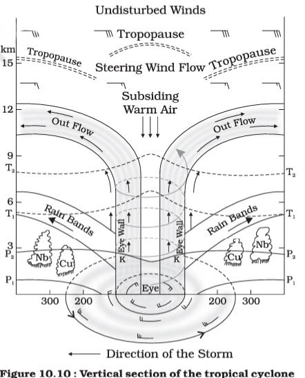
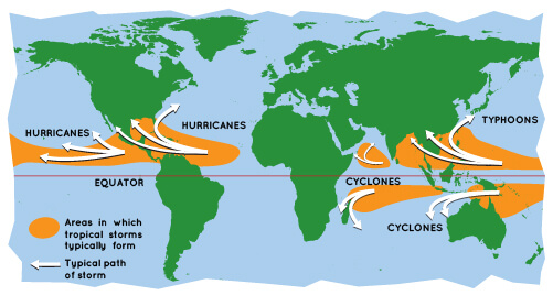
What is sea surface temperature rise? How does it affect the formation of tropical cyclone ? (Answer in 150 words)
Approach
- Define Sea Surface Temperature (SST).
- Explain the role of SST rise in the formation of tropical cyclone.
- To conclude, suggest safeguarding mechanisms for rising sea surface temperature.
Introduction
Sea Surface Temperature (SST) is defined as the temperature of the uppermost layer of the ocean. The rise in sea surface temperature is primarily driven by human-induced climate change, with significant contributions from greenhouse gas emissions.SST plays a crucial role in influencing weather patterns, especially in the formation of tropical cyclones.
Body
Impact of SST Rise on Tropical Cyclone Formation :
- Energy Source: Rising sea surface temperatures provide the necessary heat and moisture, which are crucial for the formation and intensification of tropical cyclones.
- Convection: Higher SSTs enhance convection processes, leading to the development of tropical cyclones.
- Development Threshold: If SSTs are below the 26°C threshold, the energy available for cyclone development is insufficient.
- Intensity: Warmer SSTs not only initiate cyclone formation but also contribute to the intensification of existing storms, potentially increasing their wind speeds and destructive capacity.
- Frequency:Rising global temperatures may increase the frequency and intensity of tropical cyclones by raising sea surface temperatures.
- Changing Tracks: As SSTs rise globally, tropical cyclones may form in new regions or shift their paths, affecting areas previously unaffected.
Conclusion
To safeguard marine ecosystems from rising sea surface temperatures, it is essential to reduce greenhouse gas emissions and develop climate-resilient infrastructure. At the same time, conserving marine ecosystems through sustainable practices and improving forecasting capabilities will enhance the region's resilience to extreme weather events.
-
2024
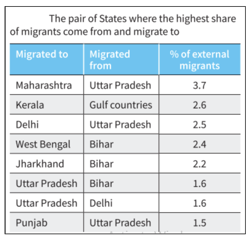
Why do large cities tend to attract more migrants than smaller towns? Discuss in the light of conditions in developing countries. (Answer in 150 words)
Approach
- Define Migration and give few data.
- Mention the factors that attract migrants to larger cities
- Conclusion
Introduction
Migration is the movement of people from one place to another in pursuit of improved job opportunities and living conditions. According to the Periodic Labour Force Survey, rural-to-urban migration accounts for 18.9% of total internal migration in India.
Body
Factors that Attract Migrants to Larger Cities
- Infrastructure and Services: Larger cities provide better infrastructure, including transportation, housing, and utilities, making them more appealing to migrants.
- Education and Healthcare: Urban areas typically have better educational institutions and healthcare facilities, which attract families looking for improved services and quality of life.
- For example, people from Bihar and Jharkhand migrate to states like Delhi and Kolkata in search of better education and healthcare opportunities.
- Economic Opportunities: As compared to smaller towns, larger towns provide better work opportunities like higher wages, and diverse employment sectors compared to smaller towns.
- In India, the Migration Survey (2020-21) indicates that about 22% of internal migrants moved for economic reasons, from states like Uttar Pradesh and Bihar to Maharashtra and West Bengal respectively.
- Cultural and Social Amenities: The availability of cultural, recreational, and social amenities in cities like the internet and increased exposure to social media enhances the overall living experience, making urban areas more attractive.
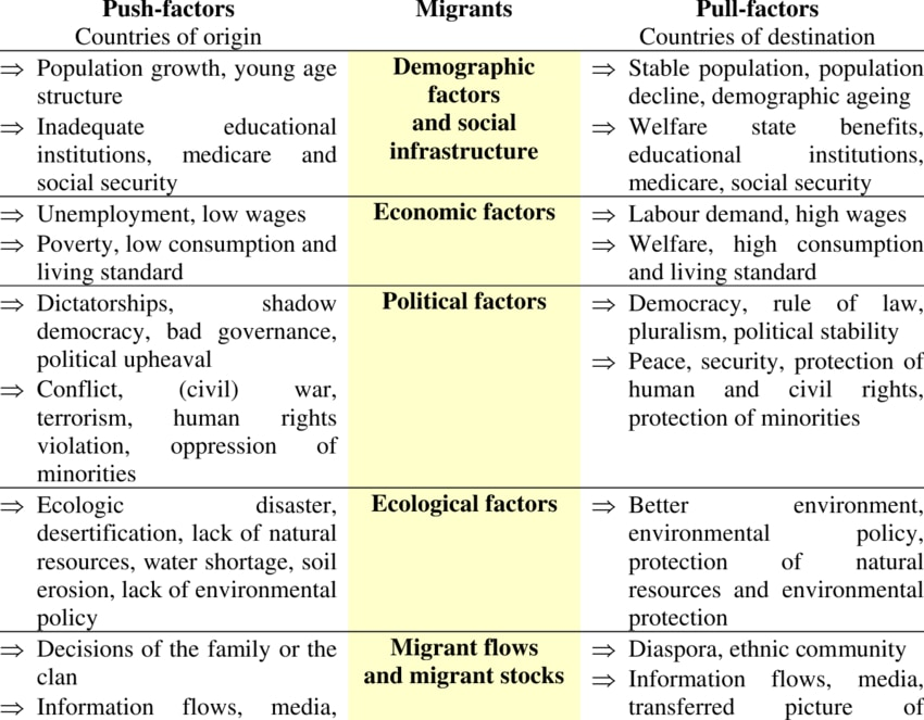
Conclusion
The sphere of influence in migration defines the geographical areas that supply migrants to specific destinations. Recognizing these spheres enables policymakers to tackle migration challenges and create more balanced regional strategies.
-
2024
What is the phenomenon of cloudbursts? Explain. (Answer in 150 words)
Approach
- Introduce the phenomenon of cloudburst with recent examples.
- Mention the mechanism and impacts of cloudburst
- Conclude Suitably
Introduction
Cloudbursts are intense rainfall events, exceeding 100 mm/h, over a small area of 20-30 square km. Recent cloudbursts in hilly regions like Uttarakhand and Himachal Pradesh have highlighted this phenomenon.
Body
Mechanism of Cloudburst
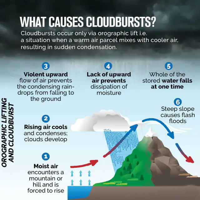
Cloudbursts happen when warm, moist air rapidly rises due to various factors like:
- Orographic lift: Moist air is pushed upward by mountains or hills, cooling quickly and condensing into heavy rainfall.
- Convective processes: The warm air near the surface rises due to temperature differences and forms cumulonimbus clouds.
- If the air at higher altitudes cools rapidly, it can trap the moisture, leading to sudden, concentrated rainfall.
When the moisture in these clouds becomes too heavy, it is released in a short, violent downpour, often accompanied by thunder and lightning.
Impacts:
- Flash Floods: Sudden water release causes rivers to overflow, devastating communities.
- Landslides: Rain in mountainous areas triggers landslides.
- Infrastructure Damage: Roads, bridges, and buildings suffer severe damage.
- Loss of Life: Cloudbursts, especially in hilly areas, can lead to fatalities.
Conclusion
India has seen a rise in cloudburst events, especially in vulnerable areas like the Himalayas and coastal cities. Improved weather monitoring and climate adaptation plans are urgently needed to mitigate these disasters.
-
2024
What is the concept of a 'demographic winter'? Is the world moving towards such a situation? Elaborate. (Answer in 150 words)
Approach:
- Begin by defining demographic winter.
- Explain the concept of demographic winter, highlighting its causes.
- Conclude by summarizing its incidence and a brief on how to address it.
Introduction
The term "Demographic Winter" refers to a significant decrease in birth rates, accompanied by an aging population with a dwindling working-age population. This trend is observed in many nations.
Body:
Causes of Demographic Winter
- Low Fertility Rates: The global fertility rate has declined from about 5 children per woman in 1960 to approximately 2.3 in 2021.
- Fertility rates of many developed countries have gone below the replacement level (2.1).
- Countries like Japan (1.26), South Korea (0.78), and Italy (1.24) have some of the lowest fertility rates in the world.
- Aging Population: By 2020, around 9% of the global population was aged 65 or older, projected to rise to about 16% by 2050.
- In Europe, more than 20% of the population is already over 65.
- Changing Family Structures: Societal shifts, including delayed marriage and childbearing, as well as a rise in single-person households, contribute to lower birth rates.
- Economic Pressures: High living costs, housing prices, and job insecurity discourage families from having more children.
Conclusion
Demographic Winter in developed regions requires comprehensive policies on family support, workforce participation, and increased immigration to sustain economic growth and social systems.
-
2024
The groundwater potential of the Gangetic valley is on a serious decline. How may it affect the food security of India? (Answer in 250 words)
Approach:
- Begin by giving a brief of the problem.
- Enlist the reasons for declining groundwater and explain how food security will be hampered with declining groundwater availability.
- Conclude by writing about how to address the issue.
Introduction
The Gangetic valley, with its fertile alluvial soil and abundant water supply has supported dense populations for millennia, fostering civilizations and cultures. As per the Central Ground Water Board groundwater levels are declining at an alarming rate of 0.5 to 1 meter per year in this area.
Body
Reasons for Declining Groundwater
- Rapid Urbanization: A rise in demand leads to over-extraction of groundwater. Unregulated drilling of borewells is a major cause.
- Over-Irrigation: A problem of abundance, this leads to detereorating soil health as well.
- Inadequate Rainwater Harvesting: Despite abundant monsoons, rainwater is lost instead of replenishing the groundwater.
- Climate Change and Erratic Rainfall: Irregular rainfall patterns, prolonged droughts, and increased evaporation due to rising temperatures hinder groundwater recharge.
Food Security Amid Crisis
- Reduced Crop Yields: With less groundwater available, farmers will face water shortages for irrigation, especially during dry seasons.
- This can lead to lower crop yields for water-intensive crops like rice and wheat, which are staples in India.
- Increased Dependence on Rainfall: As groundwater levels drop, farmers will rely more on unpredictable monsoons.
- Making agriculture more vulnerable to droughts and erratic rainfall patterns, resulting in unstable food production.
- Higher Costs of Production: Farmers may need to dig deeper wells or invest in more expensive water extraction methods, raising the cost of cultivation.
- This will in turn make food more expensive and less accessible, impacting affordability.
- Loss of Livelihoods: Declining groundwater could force small and marginal farmers to abandon agriculture, reducing agricultural output and threatening rural livelihoods, further affecting food security.
Addressing Groundwater Decline
- Promote Efficient Irrigation techniques like drip and sprinkler irrigation.
- Implement rainwater harvesting systems in urban and rural areas to recharge groundwater levels.
- Shift from water-intensive crops like rice and sugarcane.
- Encouraging water efficient and technologically advanced methods of construction.
- Policy interventions such as providing financial incentives for farmers to adopt water-efficient technologies and practices is required.
- Proper implementation of river rejuvenation programmes such as Namami Gange, with addition of artificial recharge structures can help recharge groundwater.
Conclusion
The decreasing groundwater potential in the Gangetic Valley threatens India's food security. Immediate actions are essential for sustainable groundwater management and adapting agricultural practices to secure the country's long-term food supply.
-
2024
What are aurora australis and aurora borealis? How are these triggered? (Answer in 250 words) (Answer in 250 words)
Approach:
- Explain Aurora
- Explain types of aurora and how are they triggered
- Conclusion
- Answer-
Introduction
An aurora is a natural light display that shimmers in the sky. These are visible only at night, and usually only appear in lower polar regions. Auroras primarily appear near the poles of both the northern and southern hemispheres all year round but sometimes they expand to lower latitudes.
Body
Types of Aurora
- Aurora Australis (Southern Lights): Visible in the Southern Hemisphere, especially around the Antarctic Circle, in countries like Australia, New Zealand, Antarctica, and southern parts of South America.
- Aurora Borealis (Northern Lights): Seen near the Arctic Circle, caused by solar particles interacting with Earth’s magnetic field and atmosphere. It displays green, red, and purple lights in countries like Norway, Sweden, Finland, Iceland, Canada, and Alaska.
Auroras are Triggered By
- Solar Winds: Interaction of Solar Wind particles produced by sun with earth magnetic fields trigger auroras.
- Coronal Mass Ejections (CMEs): CMEs are huge bubbles of coronal plasma threaded by intense magnetic field lines that are ejected from the Sun over the course of several hours. These can enhance auroral activity by increasing the number of charged particles reaching Earth.
- Magnetosphere Disturbances: It plays a crucial role in triggering auroras. When the solar wind, which consists of charged particles from the Sun, interacts with Earth’s magnetosphere, it causes disturbances.
- Atmospheric Interaction: Charged particles, primarily electrons and protons, are directed towards the polar regions by Earth’s magnetic field. When these particles collide with gases in the upper atmosphere, they excite these gasses, resulting in the emission of light.
Conclusion
Auroras are the outcome of intricate space weather events, showcasing the dynamic interplay between Earth’s magnetic field and solar activity. The recent occurrence of which was seen at Hanle village in Ladakh in the form of aurora borealis.
-
2024
What is a twister? Why are the majority of twisters observed in areas around the Gulf of Mexico? (Answer in 250 words)
Approach
- Introduce the answer by defining Twisters.
- Mention the reasons of frequent occurrence of twister in Gulf of Mexico
- Conclude by summarizing key points.
Introduction
A twister (tornadoes) is a violent windstorm featuring a twisting, funnel-shaped cloud. It consists of a rotating column of air that connects the Earth's surface to a cumulonimbus cloud, or occasionally a cumulus cloud. They can occur globally but are most common in the Gulf of Mexico region.
Body:
Factors that lead to frequent occurrence of Twisters in Gulf of Mexico:
- Warm, Moist Air: The Gulf of Mexico supplies warm, moist air that rises, creating conditions for thunderstorms.
- Cold, Dry Air: Cold, dry air from the Rocky Mountains or Canada moves south, clashing with warm, moist air and causing atmospheric instability.
- Wind Shear: Variations in wind speed and direction at different altitudes create wind shear, leading to a horizontal spinning effect essential for tornado formation.
- Geographical Features: The flat terrain of the Great Plains and Mississippi River Valley heats quickly, providing ideal conditions for tornadoes.
- Tropical Storms and Hurricanes: The Gulf is prone to tropical storms and hurricanes that can spawn tornadoes upon landfall.
Conclusion
Thus twisters, or tornadoes, are destructive windstorms formed by rotating columns of air. The Gulf of Mexico region experiences frequent tornadoes due to the collision of warm, moist air with cold, dry air, along with favorable geography and seasonal patterns.
-
2023
Discuss the consequence of Climate change on the food security in tropical countries.
Climate change impacts crop yields, water resources, biodiversity, food costs, and public health.
Some of the consequences are:
- Reduced crop yields: Higher temperatures, changing rainfall patterns, and more frequent and intense droughts and floods can reduce crop yields and quality.
- In Sub-Saharan Africa, maize yields have declined by 5.8%.
- Altered growing seasons: Climate change can alter farming seasons, harming agriculture's productivity.
- In India, climate change is leading to erratic rainfall patterns and shorter growing seasons for crops like rice.
- Food price volatility: Climate change can disrupt food supply and demand, causing price instability and harming food access.
- The 2007-2008 food crisis was partly triggered by climatic factors such as droughts and floods.
- Increased vulnerability: Tropical countries face increased vulnerability to cyclones, and storms, leading to damage to crops, and food systems.
- In 2021, Cyclone Amphan caused widespread damage to agriculture and fisheries in India.
To boost food security in tropical countries, we require adaptation and mitigation measures such as:
- Enhancing land management to reduce emissions and increase carbon sequestration.
- Developing resilient crop varieties.
- Diversifying food production systems and diets.
- Promoting healthy and sustainable eating habits.
- Reducing food waste throughout the supply chain.
- Reduced crop yields: Higher temperatures, changing rainfall patterns, and more frequent and intense droughts and floods can reduce crop yields and quality.
-
2023
Why is the world today confronted with a crisis of availability of and access to freshwater resources?
Freshwater is essential for survival, health, and development. However, the world today is facing a crisis of freshwater. As per the UN, over 2 billion people live in countries with high water stress.
Key reasons behind declining freshwater resources:
- Climate change: Global warming disrupts the hydrological cycle, leading to precipitation shifts, glacier melt, droughts and floods, damaging freshwater resources.
- Cape Town’s “Day Zero” in 2018, where the city nearly ran out of water due to consecutive years of drought.
- Over-extraction: Overexploitation through irrigation, mining, and more, causing freshwater depletion and degradation.
- The Aral Sea, once the world's 4th-largest lake, has nearly vanished due to irrigation water diversion.
- Pollution: Polluting freshwater with untreated wastewater, industrial waste, agricultural runoff, and solid waste reduces its availability.
- Over 80% of wastewater is released without treatment, according to the UN.
- Loss of natural reservoirs: Harm to ecosystems that control water storage and filtration, like wetlands, forests, and aquifers.
- Lake Kolleru in Andhra Pradesh, is one of the largest freshwater lakes, but it's rapidly shrinking.
Some remedial measures:
- Promote water-saving practices like rainwater harvesting. (Tamil Nadu's 'Namma Ooru-Namma Veetu' initiative).
- Adopt water-efficient farming methods such as precision agriculture and conservation tillage.
- Use innovative solutions like smart irrigation systems and water-efficient appliances. ('Sarvajal' project's solar-powered water ATMs).
- Reduce water footprint through minimization, and offsetting of water use.
- Climate change: Global warming disrupts the hydrological cycle, leading to precipitation shifts, glacier melt, droughts and floods, damaging freshwater resources.
-
2023
How are the fjords formed? Why do they constitute some of the most picturesque areas of the world?
Fjords are long, narrow, and deep inlets of the sea that are surrounded by steep cliffs or mountains. They are formed by the erosion of glacial ice, and are found in regions where the sea level has risen after the ice age.
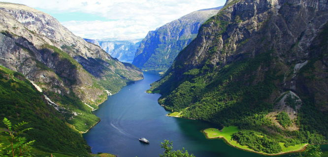
Some countries that have fjords are Norway, Chile, New Zealand, and the U.S. state of Alaska.
Fjords are some of the most picturesque areas because of their unique and dramatic landscape features. Some of the reasons are:
- The contrast between the calm, blue water and the rugged, snow-capped mountains.
- The reflection of the mountains and the sky on the water surface.
- The interplay of light and shadow on the water and the cliffs.
- The biodiversity of the fjords supports a variety of marine and terrestrial life forms, such as seals, penguins, dolphins, whales, seabirds, and plants.
- Fjord culture embodies centuries of history, with farms, villages, churches, and monuments harmonizing with the stunning natural surroundings.
- The recreational opportunities of the fjords attract tourists. Some of the activities include hiking, kayaking, fishing, skiing, and cruising.
Therefore, fjords are remarkable examples of how nature and culture can create some of the most picturesque areas of the world.
-
2023
Why is the South-West Monsoon called ‘Purvaiya’ (easterly) in Bhojpur Region? How has this directional seasonal wind system influenced the cultured ethos of the region?
The South-West Monsoon, active from June to September, delivers substantial rainfall to India. When these monsoon winds encounter various mountain ranges, they alter course, creating easterly 'Purvaiya' winds in the Bhojpur region. This distinct wind pattern significantly shapes Bhojpur's cultural identity, spanning parts of India and Nepal.
Influence of Purvaiya on Cultural Ethos of Bhojpur:
- Agriculture and Festivals: Purvaiya starts the planting season and is celebrated with festivals like Teej.
- Rituals and Beliefs: People worship rain gods like Indra and Parjanya for good harvests. Madhushravani involves worshiping Vishahara and Gosaun.
- Traditional Cuisine: Purvaiya enables the growth of rice, vegetables, and fruits, influencing the region’s cuisine. Also, special dishes like Pua are made during this season.
- Folklore: ‘Purvaiya’ appears in proverbs, songs, and poems that express the winds’ importance and emotions. Proverbs like “Purvaiya chale to khet khile” and folk songs like ‘Birha’ are examples.
Therefore, Purvaiya winds are essential to Bhojpur’s culture, shaping its traditions, rituals, and daily life.
-
2023
Comment on the resource potentials of the long coastline of India and highlight the status of natural hazard preparedness in these areas.
India's long coastline, stretching over 7,500 kilometers along the Arabian Sea and the Bay of Bengal, presents a wealth of resource potentials as well as significant challenges related to natural hazard preparedness.
- Resource Potentials of India's Coastline:
- Fisheries: India's coastline is abundant in marine life, making it a crucial hub for fisheries. It supports a thriving fishing industry, contributing significantly to the country's food security.
- Ports and Shipping: The coastline hosts several major ports, such as Mumbai, Chennai, and Kolkata, facilitating trade and commerce.
- Tourism: Coastal regions, including Goa, Kerala, and Andaman and Nicobar Islands, are popular tourist destinations due to their scenic beauty and cultural attractions.
- Mineral Resources: Coastal areas are often rich in mineral resources, including sand, salt, and minerals like ilmenite, garnet, and monazite.
- Renewable Energy: India's coastline has immense potential for renewable energy generation, particularly through offshore wind and tidal energy projects.
- Status of Natural Hazard Preparedness:
- While India's coastline offers significant opportunities, it is also highly vulnerable to natural hazards, including cyclones, tsunamis, and sea-level rise:
- India has been actively monitoring sea-level changes, bolstering coastal infrastructure resilience, conserving mangroves, and engaging in urban planning.
- This includes establishing the National Disaster Management Authority (NDMA) and State Disaster Management Authorities (SDMAs) to coordinate disaster response and preparedness at national and state levels.
- Early warning systems, particularly for cyclones, have been improved, saving countless lives.
- India has established an advanced Indian Tsunami Early Warning Centre (ITEWC), which is operated by the Indian National Centre for Ocean Information Services (INCOIS).
- The INCOIS and National Institute of Ocean Technology (NIOT) are key agencies for monitoring and understanding trends and variations in sea levels.
- While India's coastline offers significant opportunities, it is also highly vulnerable to natural hazards, including cyclones, tsunamis, and sea-level rise:
India's vulnerable coastal regions require ongoing efforts in disaster preparedness, infrastructure development, and climate adaptation for sustainable growth.
- Resource Potentials of India's Coastline:
-
2023
Identify and discuss the factors responsible for diversity of natural vegetation in India. Assess the significance of wildlife sanctuaries in rain forest regions of India.
India's natural vegetation exhibits remarkable diversity owing to a myriad of geographical, climatic, and ecological factors.
- Factors Responsible for Diversity of Natural Vegetation in India:
- Geographic Variation: India's extensive and varied geography, spanning from the northern Himalayas to the southern coast, results in diverse ecosystems and vegetation due to a wide range of climatic conditions.
- Climatic Variation: India's diverse climates, from tropical in the south to temperate in the north, directly impact regional vegetation patterns.
- Monsoon Winds: The monsoon winds deliver substantial rainfall, leading to the growth of tropical rainforests in certain areas and supporting xerophytic vegetation in arid regions.
- Altitude: India's diverse altitudes, from the Himalayas to lower regions, contribute to varied vegetation, with alpine flora at higher altitudes and temperate forests at lower ones.
- Soil Types: India's diverse soil types, including alluvial, red, laterite, and desert soils, impact plant species and its distribution through varied vegetation support.
- Significance of Wildlife Sanctuaries in Rainforest Regions of India:
- Biodiversity Conservation: It provides protected habitats for a wide variety of plant and animal species, some of which may be endangered or endemic.
- Research and Education: These sanctuaries serve as living laboratories for researchers and conservationists to study and understand complex ecosystems.
- Tourism and Economic Benefits: Well-managed wildlife sanctuaries can attract ecotourism, providing economic benefits to local communities.
- Carbon Sequestration: Rainforests are vital in sequestering carbon dioxide from the atmosphere.
- Ecological Balance: Rainforests play a vital role in ecological balance, providing essential ecosystem services like water purification, soil fertility, and pollination.
India's diverse natural vegetation results from geography, climate, altitude, soil, and biodiversity, while rainforest wildlife sanctuaries are crucial for conservation, research, tourism, carbon sequestration, and ecological health.
- Factors Responsible for Diversity of Natural Vegetation in India:
-
2023
Why did human development fail to keep pace with economic development in India?
The divergence between economic development and human development in India can be attributed to several complex and interconnected factors:
- Income Inequality: Persistent income inequality in India disproportionately benefits the wealthy, hampering equitable access to healthcare, education, and basic services for a significant portion of the population.
- Education Disparities: Despite economic growth, India faces education related challenges like high dropout rates, inadequate infrastructure, and poor quality, limiting human capital development and workforce participation.
- Healthcare Inequities: Unequal healthcare access, especially in rural areas, contributes to high disease burdens and child mortality rates, impacting human development indicators, compounded by limited access to clean water and sanitation.
- Gender Disparities: Gender inequality in India restricts women's access to education, healthcare, and economic opportunities, while gender-based violence and discrimination further hinder their development.
- Social Exclusion: India's caste system and social hierarchies historically marginalize communities, limiting their opportunities and affecting human development outcomes.
- Inadequate Social Safety Nets: India's welfare programs often fall short in addressing the needs of vulnerable populations, offering limited protection against poverty and malnutrition.
- Environmental Degradation: Unsustainable development and environmental degradation for economic growth have long-term consequences, with climate change, pollution, and resource depletion threatening well-being.
- Governance Challenges: Weak governance, corruption, and inefficient bureaucracy can hinder the effective implementation of policies and programs.
However, India has achieved significant growth over the years in social, economic, and political life and human development has also been catching up with the pace of economic development eg. in 1990, India's HDI score was 0.429, which increased to 0.633 by 2021.
-
2023
From being a net food importer in the 1960's, India has emerged as a net food exporter to the world. Provide Reasons.
Since the 1960s, when it was forced to rely on imports and food aid from other nations due to chronic food shortages, India has made great advancements in its ability to produce and export food.
According to WTO's Trade Statistical Review (2022), India was in the top 10 ranking of the global Agri exporters.
Some of the major factors are mentioned as below:
- Green Revolution: The green revolution initiated in the mid 1960’s boosted agricultural productivity, food grain production and better irrigation infrastructure.
- Government Policies: Supportive government policies such as Minimum Support Price , e-NAM, subsidized inputs, better procurement system incentivised farmers to increase food production.
- Research and Development: Investment in agricultural research and development helped in adoption of better technologies and methods. E.g Indian council for agriculture research.
- Private Sector Participation: Private sector involvement in agriculture and allied fields such as food processing industries etc. lead to better infrastructure, better market access and better market prices e.g e-Choupal ,Tata Kisan Kendras.
- Diversification of Crops: The government’s focus on diversifying India's food supply e.g.Launching technology mission, Crop diversification programme (CDP) etc.
- Trade liberalization: Trade liberalization in the 1990's and thereafter too contributed to better exports.
- Global Demand: More global demand in the ever expanding world markets has also boosted the prospects of Indian agriculture.
While India has made significant strides in becoming a net food exporter, certain challenges remain including climate change, sustainable agriculture,water management and to ensure that the benefit of the exports reaches to small and marginal farmers as well.
Addressing these challenges will enhance and sustain India’s position in the global food market while at the same time ensure national food security.
-
2022
Describe the characteristics and types of primary rocks.
Igneous rocks are called primary rocks because they are the first one to be formed in the rock cycle and they do not leave any organic remains. They form when hot, molten rock crystallizes and solidifies.
Depending upon where the molten rock solidifies, they can be divided into two types:
- Intrusive Igneous Rocks: They form when magma is trapped deep inside the Earth where it cools very slowly over many thousands or millions of years until it solidifies. Slow cooling means the individual mineral grains have a very long time to grow, so they grow to a relatively large size. These rocks have a coarse-grained texture. Example - Diabase, Granite, Pegmatite and Peridotite.
- Extrusive Igneous Rocks: They are produced when magma exits and cools above (or very near) the Earth's surface. These rocks form at erupting volcanoes, so molten rock erupts on the surface, the magma cools and solidifies almost instantly when it is exposed to the relatively cool temperature of the atmosphere. Quick cooling means that mineral crystals don't have much time to grow, so these rocks have a very fine-grained or even glassy texture. Hot gas bubbles are often trapped in the quenched lava, forming a bubbly, vesicular texture. Example - Basalt, Pumice, Obsidian and Andesite.
-
2022
Discuss the meaning of colour-coded weather warnings for cyclone prone areas given by India Meteorological Department.
The IMD uses four colour-coded weather warnings to signify the intensity of the weather situation and alert people about possible widespread disruption or danger to life:
- Green (All is well): No advisory is issued.
- Yellow (Be Aware): Yellow indicates severely bad weather spanning across several days. It also suggests that the weather could change for the worse, causing disruption in day-to-day activities.
- Orange (Be prepared): The orange alert is issued as a warning of extremely bad weather with the potential of disruption in commute with road and rail closures, and interruption of power supply.
- Red (Take Action): When extremely bad weather conditions are certainly going to disrupt travel and power and have significant risk to life, the red alert is issued.
In Cyclone prone areas, the IMD issues cyclone warnings to state government officials in four stages:
- Pre-Cyclone Watch - It is issued 72 hours prior and contains early warning about the development of a cyclonic disturbance in the north Indian Ocean.
- Cyclone Alert - It is issued at least 48 hours prior to the expected commencement of adverse weather over the coastal areas.
- Cyclone Warning - It is issued at least 24 hours in advance. Landfall point is forecast at this stage.
- Post Landfall Outlook - it is issued at least 12 hours in advance of the expected time of landfall. It gives the likely direction of movement of the cyclone after its landfall.
Stage of Warning Colour Code Cyclone Alert Yellow Cyclone Warning Orange Post landfall out look Red -
2022
Discuss the natural resource potentials of ‘Deccan Trap’.
Deccan Trap is a large region of thick basaltic rock located in west-central India and associated with one of the largest volcanic eruptions in the history of the earth.
- The Deccan Trap covers a significant part of western peninsular India, in states of Maharashtra, Goa, and Gujarat and to some extent in Madhya Pradesh and southern Rajasthan.
Natural resources found in Deccan Trap:
- Soil & Rocks:
- Black Soil: It is also known as “Regur Soil” or the “Black Cotton Soil”.
- Black soils are rich in iron, lime, aluminium, magnesium and also contains potassium. However, these soils are deficient in nitrogen, phosphorus and organic matter.
- Cotton, pulses, millets, castor, tobacco, sugarcane, citrus fruits, linseed, etc. are mainly cultivated in black soil.
- Rocks:
- Ancient cave temples have been carved out of the Deccan basalts in many places and the Elephanta Caves located on a small island offshore Mumbai (Bombay) is one such place.
- Black Soil: It is also known as “Regur Soil” or the “Black Cotton Soil”.
- Non-Ferrous Minerals:
- Bauxite: India’s reserves of bauxite are sufficient to keep the country self-reliant.
- Major reserves occur in Jharkhand, Maharashtra, Madhya Pradesh, Chhatisgarh, Gujarat, Karnataka, Tamil Nadu, Goa and Uttar Pradesh.
- Bauxite: India’s reserves of bauxite are sufficient to keep the country self-reliant.
- Ferrous Minerals:
- India is endowed with fairly abundant resources of iron ore. It has the largest reserve of iron ore in Asia.
- The districts Maharashtra and Goa have also emerged as important producers of iron ore.
- India is endowed with fairly abundant resources of iron ore. It has the largest reserve of iron ore in Asia.
- Natural Gas:
- It is obtained along with oil in all the oil fields, but exclusive reserves have been located along the eastern coast as well as Tripura, Rajasthan and offshore wells in Gujarat and Maharashtra.
- Recently, the National Geophysical Research Institute (NGRI) has noticed the presence of oil and natural gas in the Deccan region that spreads over a vast area including parts of Telangana, Karnataka, and Maharashtra.
- It is obtained along with oil in all the oil fields, but exclusive reserves have been located along the eastern coast as well as Tripura, Rajasthan and offshore wells in Gujarat and Maharashtra.
- Geothermal Energy:
- The western margin of volcanic Deccan traps, also known as Western Ghats, is characterized by the presence of numerous hot springs.
- Nuclear Energy:
- Nuclear energy has emerged as a viable source in recent times. Important minerals used for the generation of nuclear energy are uranium and thorium.
- The important nuclear power projects are Tarapur (Maharashtra), Rawatbhata near Kota (Rajasthan), etc.
- Nuclear energy has emerged as a viable source in recent times. Important minerals used for the generation of nuclear energy are uranium and thorium.
-
2022
Examine the potential of wind energy in India and explain the reasons for their limited spatial spread.
The wind is used to produce electricity using the kinetic energy created by air in motion. Wind turbines or wind energy conversion systems transform this into electrical energy.
Potential:
- India has the potential of about 60 GW of wind.
- It is quite likely that it would go up substantially because over time some of the old wind power stations that have very low capacity could be replaced with wind turbines that have higher capacity.
- There is another unexplored area, which is in the oceans.
- Across the world, exploration in this area is at a nascent stage.
- On the eastern side of India, there are a lot of cyclones that hit the coast.
- India is a country having around 7,516.6 km long coastline and in all of its exclusive economic zones, it has enough opportunity to harness wind energy.
- It is found by the National Institute for Wind Energy (based in Chennai) that western states have larger potential in terms of a stable, steady and speedy windflow.
- In 2022, Tamil Nadu is among the largest producer of wind energy.
Reasons:
- Wind power must compete with other low-cost energy sources.
- Wind plants can impact local wildlife.
- A wind project may face public opposition if a cultural or historically important land is being occupied by a wind farm.
- Lack of infrastructures and institutions to carry out R&D (Research & Development).
- India has the potential of about 60 GW of wind.
-
2022
What are the forces that influence ocean currents? Describe their role in fishing industry of the world.
Ocean currents are like river flow in oceans. They represent a regular volume of water in a definite path and direction.
Ocean currents are influenced by two types of forces i.e. Primary Force, which initiates the movement of water while the secondary force influences the currents to flow. These forces are:
- Primary Force:
- Heating by Solar Energy: It causes the water to expand which causes water to spread from hot to cold regions.
- Wind: Wind blowing on the ocean surface pushes the water to move on.
- Gravity: Gravity tends to pull the water down the pile and create gradient variation.
- Coriolis Force: It causes the water to move to the right in the northern hemisphere and to the left in the southern hemisphere.
- Secondary Force:
- Landmass: Interaction of ocean with landmass results in change in direction of ocean current. For example: Brazil Ocean Current.
- Salinity: Water with high salinity is denser than water with low salinity, leading to variation in ocean currents as denser water tends to sink, while relatively lighter water tends to rise.
Ocean currents affect fishing industries in the following ways:
- Creation of Fishing Zones: Meeting of cold and warm ocean currents forms fishing zones in the ocean.
- Prominent examples are North East Pacific Zone, Newfoundland (Labradour & Gulf Stream), North West Pacific Zone along Japan (kuroshio and oyashio current) etc.
- Upwelling is a process in which currents bring deep, cold water to the surface of the ocean. Upwelling is a result of winds and the rotation of the Earth.
- Movement of Planktons: Planktons are the organisms that come with ocean currents. They act as the base of the marine food chain and attract the fish populations towards them, leading to accumulation of fishes in a particular zone.
- Upwelling is a process in which currents bring deep, cold water to the surface of the ocean. The deeper water that rises to the surface during upwelling is rich in nutrients. These nutrients “fertilize” surface waters, encouraging the growth of plant life, including phytoplankton.
- Long Shelf Life: Fishes in cold ocean currents have longer shelf life as compared to warm ocean currents, leading to non-perishable fish products.
- Ecological Balance: Ocean currents maintain ecological balance by transferring water to the areas of less oceanic current and having low fish population to maintain oxygen level and fishes in the deficit area. Example: Saragasso Sea; Dead Zone.
Although ocean current is the main player in creating fishing zones, the use of technology could be carried to develop fishing industries in other potential zones as well.
- Primary Force:
-
2022
Describing the distribution of rubber producing countries, indicate the major environmental issues faced by them.
- Natural rubber is a polymer of isoprene, an organic compound. It comes from various sources, the most common being the Pará rubber tree (Hevea brasiliensis).
- Distribution of rubber producing countries: Thailand produced 35% share of global natural rubber in 2020 followed by Indonesia.
- The tropical climate supports healthy rubber trees. It thrives in deep soil with resistance to flooding and in areas where the annual rainfall remains between 60 and 78 inches.
- Despite natural rubber being native to the Amazon basin, approximately 90% of the world’s supply is grown in Asia. Much of this comes from Southeast Asia – specifically Thailand, Indonesia, Vietnam, and Malaysia.
- The other countries of the world that are producing the rubbers are Ivory coast, Brazil, Mexico, Gabon, Guina, Ecuador and Sri Lanka etc.
Environmental issues:
- The rubber cultivation is a plantation crop and takes a long gestation period to become a fruitful crop for providing monetary benefits. This plantation incurs many negative externalities like:
- Countries like Malysia and Indonesia has lost a large part of its natural forest due to cultivation of Rubber.
- It also leads to extinction of biodiversity and population of some of the iconic species like orangutans have reduced.
- Preference to plantation crops like Rubber reduces the cultivation of the food crops and reduces the chance to achieve SDGs.
- Monotonous cropping pattern reduces the rejuvenation capacity of the soil and the accelerated application of the synthetic fertilizer further reduces the capacity of the soil and residue fertilizer prevails various illnesses in the society.
- The long gestation period of the rubber plantation (7-8 years) makes it more vulnerable to pests and other climate induced diseases and illnesses that hamper the interest of the small crop holders and bring the issue of livelihood.
- The rubber plantation itself is the source of various pollution and GHGs like:
- The open burning of rubber plantation wastes in the form of rubber tree stumps after land clearing (in Malaysia).
- Per kg dry rubber generates eight kg of effluents and its Natural degradation releases a huge amount of carbon dioxide (CO2) and methane.
- The emission of the rubber industry has been linked to various diseases and diverse impacts on human health.
- The rubber industry is one of the major water polluting industries. It accelerates the problem of water scarcity in the rubber producing countries.
- Countries like Malysia and Indonesia has lost a large part of its natural forest due to cultivation of Rubber.
Increasing demand of rubber due to industrial expansion, the sustainable cultivation of rubber is the only way forward. The synthesis of local and global knowledge with the use of modern technology can prevail in the interest of all the stakeholders involved in the industry.
-
2022
Mention the significance of straits and isthmus in international trade.
- A strait is a narrow oceanic waterbody connecting two seas or two other large water bodies. It acts as a passage or gallery for ships in the water between water bodies. E.g., Malacca strait, Gibraltar strait, etc.
- An isthmus is a narrow strip of land that connects two larger landmasses and separates two bodies of water. E.g., Isthmus of Suez, connecting Africa and Asia.
Significance of Staits and Isthmus in international trade:
- They reduce distance between the places and facilitate greater trade. E.g., the Suez Canal on the isthmus of Suez prevents the circumvent of the Africa by ships for trade between Asia and Europe.
- The straits and isthmus also provide good harbor and ports leading to international trade facilitation. E.g., Singapore port on the Malacca strait.
- It also provides connectivity between lager landmass and the water bodies. Like Panamá Canal on isthmus of Panama connects Atlantic and Pacific oceans.
- It also revolutionizes the shipping industry by facilitating efficient transportation.
- It provides the bridge between the demand and supply of the commodity. E.g., Japan buys the iron ore of India through the strait of Malacca.
- It provides environmentally friendly shipping. E.g., By making the Palk Strait deeper, Indian ships could circumvent Sri Lanka (a long route) while transporting goods from Vizag to Kochin (saving fuel).
- It facilitates the export and import of international trade in tourism services by providing recreational services along the coasts of the isthmus and straits.
- It provides good ground for fishing and aquaculture and thus, promotes international trade in marine products.
- It also provides the strategic place for defence establishment that facilitates international trade by providing security from pirates.
-
2022
Troposphere is a very significant atmosphere layer that determines weather processes. How?
The troposphere is the first and lowest layer of the atmosphere of the Earth. Most of the mass (about 75-80%) of the atmosphere is in the troposphere, and is where most weather phenomena occur.
- Weather refers to short-lived temperature, wind and precipitation conditions that vary from place to place.
- Elements of Weather Processes: Cloud cover, rain, snow, low or high temperatures, storms and wind.
Layers of Atmosphere Height ( in km) Exosphere Beyond 400 Thermosphere 80- 400 Mesosphere 50- 80 Stratosphere 10- 50 Troposphere 0- 10 Significance of Troposphere in Determination of Weather Phenomena:
- Increasing altitude decreases temperature in the troposphere, thus keeping water from leaving this atmospheric layer.
- That’s why the troposphere contains 99% of the total mass of water vapour and aerosols in the atmosphere, and it is therefore the source of most of the clouds that induce weather phenomena.
- Ozone absorbs sunlight in the stratosphere to raise the air temperature. Thus, temperatures in the stratosphere generally rise with elevation (opposite in case of troposphere)
- The Stratosphere acts as a knot that inhibits vertical motion of winds, resulting in weather phenomena that can only be seen in the troposphere.
- In the troposphere, water evaporates from the surface of the earth and is transported by the wind to other regions.
- The rise, expansion, and cooling of air causes water vapour to condense into clouds, producing an unstable atmosphere that causes rain.
- Global winds and fronts occur in the troposphere creating weather events such as thunderstorms, hurricanes, tornadoes, and blizzards.
Temperatures and weather patterns are shifting due to climate change, causing abnormal weather phenomena in the Troposphere like Heat Waves (recently in Europe and India). Therefore, there is a need to take urgent action to combat climate change and its impact (Sustainable Development Goal 13).
- Weather refers to short-lived temperature, wind and precipitation conditions that vary from place to place.
-
2021
Differentiate the causes of landslides in the Himalayan region and Western Ghats.
A landslide is defined as the movement of a mass of rock, debris, or earth down a slope. They are a type of mass wasting, which denotes any downward movement of soil and rock under the direct influence of gravity. Landslides are caused due to three major factors: geology, morphology, and human activity.
Causes of landslides in Himalayan region:
- Geology: Himalayas are young, fragile mountains still growing, hence susceptible to natural landslides, tectonic activity, with the plate moving up which causes instability.
- Morphological: Steep and sharp slope in the Himalayas.
- Anthropogenic: These include, jhum cultivation, deforestation etc., leading to landslides.
Causes of landslides in Western Ghats:
- Geology: These factors play a very little role here as the Western Ghats are one of the most stable landmasses.
- Anthropogenic: Heavy mining activities, deforestation for settlements and cutting for road construction, windmill projects have led to huge fractures on the mountains, loosening structures.
Following measures for the mitigation of landslides can be taken:
- Restriction on the construction and other developmental activities such as roads and dams in the areas prone to landslides.
- Limiting agriculture to valleys and areas with moderate slopes.
- Promoting large-scale afforestation programmes and construction of bunds to reduce the flow of water.
Terrace farming should be encouraged in the north-eastern hill states where Jhumming (Slash and Burn/Shifting Cultivation) is still prevalent.
-
2021
Despite India being one of the countries of Gondwanaland, its mining industry contributes much less to its Gross Domestic Product (GDP) in percentage. Discuss.
Despite being a part of Gondwana land, rich in providing minerals such as coal, iron, mica, aluminium, etc., the contribution of the mining sector to India’s GDP has been on a steady decline. Contribution by the mining sector to India’s GDP is only 1.75%. Whereas other countries like South Africa and Australia contribute 7.5% and 6.99%.
Reasons:
- Mining is harmful from an environmental point of view. There has hardly been a mining project that did not face opposition on this front.
- Several tribal communities and Particularly Vulnerable Tribal Groups (PVTGs) fall into the mining zones. Their residence is also threatened by an increase in mining. Their rehabilitation and compensation is another major issue.
- The auction of a mine is a process where the power rests in the hands of State governments. There might exist ambiguity in the case where there are two different political parties in power at the Center and the State.
- There are also issues like technological advancements and availability of cheap funds. Lack of these is the major determinant in poor growth of the mining industry.
- India has majorly been an exporter of raw materials and an importer of finished products made out of those raw materials. As the raw materials are sold at dirt cheap rates, it reflects poorly in the GDP calculations.
-
2021
What are the environmental implications of the reclamation of the water bodies into urban land use? Explain with examples.
Land reclamation means creating land either by removing water from muddy areas or raising the level of the land. With an increasing demand for land, it can be a good solution for creating areas for building, agriculture and other uses.
However, it is one of the most consequential fields of human induced environmental transformation and has many environmental consequences such as:
- Damaged Ecology: Urban land transformation leads to creation of residential, commercial buildings around water bodies, causing degradation of water ecology and influx of nutrients. Dal Lake and other water bodies in Srinagar are a great example of it. Land reclamation can also change the shape of the seabed and wave patterns leading to changes in the ecosystem.
- Frequent Floods: Water bodies act as sponges for rainfall, reclamation of water bodies, has led to higher incidences of floods. Depletion of vegetation, transformation of soil cover to concretised landscape has reduced permeability, increased run-off. The biggest example of it is Mumbai.
- Extinction of Species: Land reclamation of wetlands has increased the Biochemical Oxygen Demand (BOD) which is detrimental not only for aquatic species but also for aerial fauna.
- Pollution: Water bodies have been turned into landfills in several cases. Because of heavy pollution of Hussainsagar Lake, many pollutants get carried into underground water bodies. Though percolation filters many pollutants, open wells or bore wells receive certain pollutants causing groundwater pollution.
Water bodies not only support high concentrations of biodiversity, but also offer a wide range of important resources and ecosystem services like food, water, fiber, groundwater recharge, water purification, flood moderation, storm protection, erosion control, carbon storage and climate regulation. Hence their conservation is an imperative.
-
2021
Mention the global occurrence of volcanic eruptions in 2021 and their impact on regional environment.
A volcano is an opening or rupture in the earth’s surface that allows magma (hot liquid and semi-liquid rock), volcanic ash and gases to escape. The volcanic eruption could have implications for the local and regional environment like earthquake, landslides, lahars (mudflows), ash and thunderstorms. 2021 witnessed several volcanic eruptions viz. Mount Sinabung (Indonesia); Klyuchevskoy (Kamchatka, Russia); Fournaise (Réunion); Mount Etna (Italy); and Erebus (Antarctica).
Impact of volcanic eruption on the environment:
- Volcanic eruptions are responsible for forming new rock on the Earth’s surface.
- The gases and dust particles thrown into the atmosphere during volcanic eruptions have influences on climate.
- Volcanoes have also caused global warming over millions of years during times in Earth’s history when extreme amounts of volcanism occurred, releasing greenhouse gases into the atmosphere.
- Even though volcanoes are in specific places on Earth, their effects can be more widely distributed as gases, dust, and ash get into the atmosphere
- Volcanic eruptions are generally preceded by increased seismic activity.
Most of the active volcanoes on earth occur on the Circum-Pacific Belt, also referred to as the Ring of Fire. Volcanoes are a natural exogenic phenomenon that cannot be avoided, but developing disaster risk resilience will surely be a step in the right direction.
-
2021
Why is India considered as a subcontinent? Elaborate your answer.
The Indian subcontinent, or simply the subcontinent, is a physiographic region in South Asia. It is situated on the Indian Plate, projecting southwards into the Indian Ocean from the Himalayas.
Geologically, the Indian subcontinent is related to the landmass that drifted from the supercontinent Gondwana during the Cretaceous and merged with the Eurasian landmass nearly 55 million years ago. Geographically, it is the peninsular region in South-Central Asia, delineated by the Himalayas in the north, the Hindu Kush in the west, and the Arakanese in the east.
This natural physical landmass in South Asia has been relatively isolated from the rest of Eurasia. The Himalayas (from Brahmaputra River in the east to Indus River in the west), Karakoram (from Indus River in the east to Yarkand River in the west) and the Hindu Kush mountains (from Yarkand River westwards) form its northern boundary. The Indian Ocean, Bay of Bengal and Arabian Sea form the boundary of the Indian subcontinent in the south, south-east and south-west.
Moreover, India’s high population and its multiple races, religions, castes, languages, customs make it look like a small continent like the subcontinent. The diversity is largely a result of physical aspects of the land itself, which in turn shaped historical events such as migrations and invasions. However, in spite of numerous differences, at the root there are numerous similarities in the socio-cultural-economic way of life.
-
2021
Briefly mention the alignment of major mountain ranges of the world and explain their impact on local weather conditions, with examples.
Mountain range refers to a series of ridges which originated in the same age and underwent the same processes. The most prominent or characteristic feature of mountain ranges is their long and narrow extension.
Mountain ranges and their influence:
- Andes Mountain Range:
- The range stretches from north to south through seven countries in South America, along the west coast of the continent: Venezuela, Colombia, Ecuador, Peru, Bolivia, Chile, and Argentina.
- Because the Andes act as a large wall between the Pacific Ocean and the continent, they have a tremendous impact on weather in the region.
- The northern part of the Andes is typically rainy and warm, and the weather is also wet in the eastern part of central Andes, and the area to the southwest.
- To the west, the dry climate is dominated by the Atacama Desert in northern Chile. The mountains form a rain cover over the eastern plains of Argentina, which have extremely dry weather.
- The Himalayas:
- The Himalayan mountain ranges are stretched over the northern borders of India. These mountain ranges run in a west-east direction from the Indus to the Brahmaputra. The Himalaya consists of 3 parallel ranges in its longitudinal extent.
- The mountain range in Asia separates the plains of the Indian subcontinent from the Tibetan Plateau.
- The Himalayas have a profound effect on the climate of the Indian subcontinent and the Tibetan Plateau. They prevent frigid, dry winds from blowing south into the subcontinent, which keeps South Asia much warmer than corresponding temperate regions in the other continents.
- Rockies Mountain Range:
- These are massive mountain ranges that stretch from Canada to central New Mexico.
- These cast a fairly substantial rain shadow - a dry area on the leeward side of the mountain range, where wind does not hit, which forms because the mountains block rain-producing weather systems and create a metaphorical shadow of dryness.
- Wet weather systems begin in the Pacific Ocean and travel over the western states to the Rocky Mountains, and as the air moves higher up the western slope it cools and condenses, leaving rain and snow along the mountainside in its wake.
- Having been stripped of moisture, the air continues over the Rocky Mountains and dries out as it moves down the eastern slope. Because the air is now dry, it absorbs moisture from the landscape, leaving the earth more arid.
- Essentially, the rain shadow is a desert forced into existence because of the mountain range it borders, which prevents the eastern slopes and foothills from experiencing the same moisture that falls on the western side of the range.
- Great Dividing Range:
- It runs roughly parallel to the east coast of Australia and forms the fifth-longest land-based mountain chain in the world, and the longest entirely within a single country.
- The Great Dividing Range blocks the flow of moist air coming from the Tasman Sea. This creates rain over the range and reduces the amount of rainfall in inland regions west of the range.
- Atlas Mountains:
- The Atlas Mountains extend some 2,500 km across north-western Africa, spanning Morocco, Algeria and Tunisia. The mountain range separates the Mediterranean and Atlantic coastlines from the Sahara Desert.
- Westerly winds from the Atlantic Ocean carry moisture into the region, but the mountains act as a weather barrier between the coastal grasslands and wetlands and the Sahara Desert.
- The Atlas Range causes a rain shadow effect, preventing the areas beyond the mountains from receiving much rainfall. During the winter months, the highest peaks of the Atlas Mountains are among the few parts of Africa to see snow.
- The Ural Mountains:
- It extends from the Kara Sea to the Kazakh Steppe along the border of Kazakhstan. Geographically, this range marks the northern part of the border between Europe and Asia.
- The northern side of the mountain range receives cool, rainy weather, while the southern side is a hot desert.
- The western side of the mountain range receives warm continental winds, while the eastern side is much cooler and drier.
The mountain ranges of the world provide essential ecosystem-based services to global communities as well as inspiration and enjoyment to millions. These are particularly important for their biodiversity, water, clean air, research, cultural diversity, leisure, landscape and spiritual values.
- Andes Mountain Range:
-
2021
How do the melting of the Arctic ice and glaciers of the Antarctic differently affect the weather patterns and human activities on the Earth? Explain.
Many glaciers around the world have been rapidly melting. Human activities are at the root of this phenomenon. Specifically, since the industrial revolution, carbon dioxide and other greenhouse gas emissions have raised temperatures, even higher in the poles, and as a result, glaciers are rapidly melting, calving off into the sea and retreating on land.
Consequences of melting:
- The Arctic and Antarctic act like the world’s refrigerator. They balance out other parts of the world that absorb heat. The loss of ice and the warming waters will affect sea levels, salinity levels, and current and precipitation patterns.
- The global average sea level has risen by about 7-8 inches since 1900, and it’s getting worse. Rising seas endanger coastal cities and small island nations by exacerbating coastal flooding and storm surge.
- Permafrost in the Arctic region (ground that is permanently frozen) stores large amounts of methane, which is a greenhouse gas that contributes to climate change. As more quickly the ice is lost, more rapidly permafrost will melt. This will result in a vicious cycle that may result in a climate catastrophe.
- The melting of ice also puts the region’s vibrant biodiversity under serious threat. Many land and sea animals rely on glaciers as their natural habitats and as they disappear, so does the rich ecological life they shelter.
The solution to all of this is obvious. Climate change mitigation policies need to be implemented stringently. If CO2 emissions can be reduced over the next ten years, then glaciers can still be saved. More targeted measures may also be required.
-
2021
Discuss the multi-dimensional implications of uneven distribution of mineral oil in the world.
Petroleum is not distributed evenly around the world. Slightly less than half of the world’s proven reserves are located in the Middle East (including Iran but not North Africa). Following the Middle East are Canada and the United States, Latin America, Africa, and the region made up of Russia, Kazakhstan, and other countries that were once part of the Soviet Union.
This uneven distribution of mineral oil across the globe has many multi-dimensional implications.
- Economic: Uneven distribution of the mineral oil across the world, affects the balance of trade between the importing and the exporting countries. This in turn affects the foreign exchange reserves of the country. It also leads to economic consequences like inflation, for the importing country.
- Political: Many historical and present-day conflicts involve nations trying to control resource-rich territories. For example, the desire for diamond and oil resources has been the root of many armed conflicts in Africa. USA’s interference in the geopolitics of West Asia is also one of the reasons for uneven distribution of oil minerals.
- Employment & Migration: Availability of oil reserves leads to more job opportunities in the Middle east. That is the reason why India has a large diaspora in the middle east.
- Uneven Growth: Uneven distribution of mineral oil has also led to uneven growth across the globe. Rise in import prices directly hamper the capabilities of the government to spend on welfare objectives.
- Energy Security: The uneven distribution of the mineral oil resource is the reason for energy insecurity in the oil deficient countries. It also directly affects their strategic autonomy.
The uneven distribution of the mineral oil resources leads to various implications ranging from economic to energy security. This highlights the need for India to diversify its energy basket both in terms of content and geography.
-
2021
What are the main socio-economic implications arising out of the development of IT industries in major cities of India?
Information technology is an example of a general-purpose technology that has the potential to play an important role in economic growth, as well as other dimensions of economic and social development. The IT industry accounted for around 8% of India’s GDP in 2020.
However, IT industries in India are concentrated in a few major cities like Delhi-NCR, Hyderabad, Bengaluru, etc. This, though boosted the economy around the cities, has imprinted wider socio-economic implications.
Socio-economic implications of development of IT industry:
- Uneven development and Economic Disparity: The major cities with large IT hubs are developing faster than the semi urban and Tier I, II cities. There is also a huge wage gap between IT workers and other workers.
- Accentuating Digital Divide: Given the importance of industries, the hosting cities attract most of the developmental activities. To illustrate, lack of infrastructure in rural areas impede the access to essential services, impacting their socio-economic development.
- Increased Migration and Cultural Change: The youth migrate from rural areas and small cities to the major IT cities leaving their parents alone and needy for social and emotional support. This is leading to breakdown of joint family culture and more nuclear family culture is emerging in India.
India’s technology services industry can achieve USD 300-350 billion in annual revenue by 2025 if it can exploit the fast-emerging business potential in cloud, artificial intelligence (AI), cybersecurity and other emerging technologies. Though we need to invest in such technologies, this investment should be evenly distributed and not centred to a few locations. For example, the IT-BPO industries can be established in North East cities and Tier 1 and 2 cities. We can only become a knowledge economy if the developments are even and inclusive.
-
2020
Discuss the geophysical characteristics of Circum-Pacific Zone.
The Circum-Pacific Belt, also referred to as The Ring of Fire, is a path along the PacificOcean characterized by active volcanoes and frequent earthquakes.
Basic characteristics
- Location: A nearly continuous chain of volcanoessurroundsthe Pacific Ocean. The chain passes along the west coast of North and South America, from the Aleutian Islandsto the south of Japan, from Indonesia to the Tonga Islands, and New Zealand.
- Formation: This Circum-Pacific chain of volcanoes and themountain ranges associated with it owe theirformation to the repeated subduction of the oceanic lithosphere beneath the continents and the islands that surround the Pacific Ocean. The Ring of Fire is the result of plate tectonics (Convergent, Divergent Plate Boundary, Transform Plate Boundary).
- Formation of Hot Spots: The Ring of Fire is also home to hot spots, areas deep within the Earth’s mantle from which heat rises. This heat facilitatesthe melting of rock in the brittle, upper portion of the mantle. The melted rock, known as magma, often pushesthrough cracksin the crust to form volcanoes. The examples of volcanoes include Mount Fuji of Japan, Aleutian Islands of US, Krakatau Island of Indonesia, etc.
- Harbors Majority of Volcano & Earthquakes: 75% of Earth’s volcanoes are located along the Ring of Fire. 90% of earthquakes occur along its path, including the planet’s most violent and dramatic seismic events.
As the Circum-Pacific Belt harbors the majority of global Volcanic eruptions & Earthquakes, it holds immense significance regarding the study of the earth’s interior.
-
2020
The process of desertification does not have climate boundaries. Justify with examples.
The UN Convention to Combat Desertification (UNCCD) defines desertification as land degradation in arid, semi-arid, and dry sub-humid areas resulting from various factors, including climatic variations and human activities. It encompasses far beyond the world’s deserts, defying climate boundaries.
The vulnerability of land to desertification is mainly due to the climate, the topography, the state of the soil, the natural vegetation, and the ways in which these resources are used.
- Climate Change: Changing rain pattern, warming of land temperature, frequent flood and drought are degrading the vegetation of a particular area, thus, gradually leading to desertification.
- Loss of Natural Vegetation: Activities like deforestation, extensive exploitation and grazing of grassland are loosening the soil resulting in soil erosion. Further, soil erosion is a global phenomenon that affects almost all major biomes in the world.
- Urbanization: Urbanization isincreasing at a rapid pace. Even in India, almost 50% ofthe population is expected to live in urban areas, by 2050. As urbanization increases, the demand for resources increases, drawing more resources and leaving lands that easily succumb to desertification.
Desertification knows no climate boundaries
- According to Food and Agricultural Organisation (FAO), desertification affects about two-thirds of the countries of the world and one-third of the earth’s land surface, on which approximately one billion people live.
- Desertification is a worldwide phenomenon. It does not concern only the natural deserts, and can occur on such lands which are vulnerable to the desertification process.
- Two-thirds of the African continent is desert or drylands. The region is affected by frequent droughts, which have been particularly severe in recent years in the Horn of Africa and the Sahel.
- There are expanding deserts in China, India, encroaching sand dunes in Syria, steeply eroded mountain slopes of Nepal and overgrazed grassland in central Asian counties. In terms of the number of people affected by desertification and drought, Asia is the most severely affected continent.
- Well known for rainforests, Latin America and the Caribbean (LAC) are actually about one-fourth desert and drylands. These regions are particularly affected by land degradation, which is a factor in the vicious circle of land overexploitation, degradation, increased demands on production, greater poverty, food insecurity and migration.
As can be seen from the above arguments, desertification and its impacts are not restricted to certain climatic boundaries. That’s why UNCCD describes desertification as one of the greatest environmental challenges of our time and it must be tackled in a holistic manner.
-
2020
How will the melting of Himalayan glaciers have a far-reaching impact on the water resources of India?
India known for her rivers as blessings has both perennial and non-perennial rivers. Rivers of north India originate in Himalayas and Himalayan glaciers and are known as perennialrivers. Ganga, Bharamputra, Satluj etc. are the rivers of Himalayas.
Melting of glaciers is a phase of global warming cycle of the Earth but with the anthropogenic activities the rate of melting of glaciers has aggravated. From the past decade, the global temperature has increased which has accelerated the melting of glaciers which will impact water resources in India in several ways:
- Melting of glaciers will lead to overflow of rivers resulting into floods, breaking of dams, increased expanse of the river course etc. This will cause loss of human life, animal life, destruction of habitat and harvest.
- Increased flow of river also results in the increase of erosion power of river. The rivers will start eroding deep into the river beds which can cause overload of sedimentation and siltation.
- The sediments that rivers carry with them will be drained into sea making the sea water level saline which results into coral reefs destruction, submerging of islands and so on.
Melting of glaciers willsolve the scarcity of waterin India forshort-term. For optimumutilization,the government has to take steps like interlinking of river, formation of ponds, irrigation facilities, etc. which will help mitigate the impacts. These steps can help decrease the possibility of waterscarcity in long term as melting of glaciers will lead to decline in the availability of fresh water.
-
2020
Account for the present location of iron and steel industries away from the source of raw material, by giving examples.
The iron and steel industry is called a basic industry. It is basic because it provides the raw material for other industries such as machine tools used for further production.
The iron and steel industry istraditionally located close to the sources ofrawmaterials – iron ore, coal,manganese and limestone. For example, Jamshedpur TISCO plant. However, later it wasrealised that accessto markets, cheap labour, access to ports, and government policies are considerably more important than inputs.
- Cheap Labour: In the USA, the industry has also moved towards the southern state of Alabama because of factorslike cheap labour and globalsupply chain. Pittsburg area, which wastraditionally the hub ofthe industry, is now losing ground. It has now also called the “rust bowl” of the USA.
- Market: Japan is deficient in both iron ore and coal and almost all raw materials are imported. Japanese steel plants aremostlymarket-based. Example: The ‘Tokyo-Yokohama’ and ‘Osaka – Kobe –Heemeji’ iron steelregions.
- Port: The Vizag Steel Plant, in Visakhapatnam in Andhra Pradesh, is a port-based plant which started operating in 1992. Its port location is of advantage.
- Government Policy: In India, which is the 2nd largest crude steel producer, new steel plants which were set up in the Fourth Plan period are away from the main raw material sources in southern states to promote regional parity. Example, Salem steel plant in Karnataka.
Iron and Steel Industry, not located near the source of raw materials, are less expensive to build and operate and can be located near markets because of the abundance of scrap metal, which is the main input. Realising the changing trends ofthe industry, India in 2017 launched theNational Steel Policy to create a technologically advanced and globally competitive steel industry that promotes economic growth.
-
2020
The interlinking of rivers can provide viable solutions to the multi-dimensional inter-related problems of droughts, floods, and interrupted navigation. Critically examine.
Unlike southern states,the northern plains of India are endowed with surplus water due to the presence of perennial rivers originating from the Himalayas. The river interlinking project aimsto link 60 riversso that water from the surplus basin to deficit basin can be transferred. The project aimsto link 60 rivers,some of which include Ken-Betwa, Daman Ganga-Pinjal, Mahanadi-Godavari.
Proposed Benefits
- Hydropower Generation: The river interlinking project claims to generate a total power of 34 GW which will help India fulfil its growing requirements and commitment to the Paris Climate Deal.
- Flood Control: The objective is to conserve seasonal flows for irrigation, hydropower generation, and flood control. For instance, the linkage will transfer surplus flows of the Kosi, Gandak and Ghagra to the west.
- Drought Mitigation: The aim is to transfer water to drought-prone regions. A link with the Ganga and Yamuna is proposed to transfer the surplus water to drought-prone areas of Haryana, Rajasthan and Gujarat.
- Round the Year Navigation: As it would address the low levels of water in southern India’s rivers, it would provide around year waterways connectivity. Under the project, 10,000 km of navigation will be developed reducing the transportation cost.
- Irrigation Benefits: Interlinking of rivers will increase the country’s total irrigation potential. It will provide additional irrigation to 35 million hectares in the water-scarce regions.
Concerns with the Project
- Perennial Rivers are not so Perennial: A new analysis of rainfall data reveals that monsoon shortages grow in river basins with surplus water falling in those with scarcities.
- Federal Issue: Historically, there has been dissent on the part of the states regarding water sharing. Examples include Cauvery, Mahadayi disputes.
- Neighboring Countries: Convincing neighbours will be a tough task. For example, Bangladesh being a lower riparian state is less likely to agree to India’s interlinking project.
- High Environmental Cost: Construction of dams will lead to submerging of Himalayan forests and wide-scale displacement of people. For example, Ken-Betwa project will consume 23 sq miles of forest land. Moreover, it would harm many ecological factors like delta formation, growth of mangroves, and aquatic life.
The necessity and feasibility of river-interlinking should be seen on case to case basis, with adequate emphasis on easing out federal issues and environmental costs. Alongside, localsolutions(like better irrigation practice) and watershed management should be focused on.
-
2020
Account for the huge flooding of million cities in India including the smart ones like Hyderabad and Pune. Suggest lasting remedial measures.
Urban flooding has become a common occurrence these days in India. Several cities have suffered catastrophic flooding situations over the past few years. The latest victim of flooding were Hyderabad and Pune. According to recent studies, more than 50% of smart cities in India are prone to floods.
Some of the most common reasons for frequent flooding in urban India are as below:
- Inadequate Drainage Infrastructure: Cities like Hyderabad, Mumbai rely on a century-old drainage system, covering only a small part of the core city.
- Terrain Alteration: Lasting irreversible damage has been done to the city by property builders, property owners, and public agencies by flattening terrain and altering natural drainage routes.
- Reducing Seepage: Indian cities are becoming increasingly impervious to water, not just because of increasing built up but also because of the nature of materials used which is hard, non-porous.
- Lax Implementation: Even with provisions of rainwater harvesting, sustainable urban drainage systems, etc., in regulatory mechanisms like the Environmental Impact Assessment (EIA), adoption at user end as well as enforcement agencies remains weak.
Lasting Remedial Measures to Counter Floods
Countering urban floods is not possible through one size fits all approach as geological reasons resulting in floods are different for different cities. The following steps can be taken to mitigate the frequent urban flood situations in million plus cities:
- In the case of South Indian cities, especially like Hyderabad and Chennai, flooding takes place mainly due to sudden downpour caused by cyclonic activities. To reduce the events of floods, the need is to clear the critical areas, like waterbodies, from encroachments.
- In the Himalayan areas, cloud burst events, especially during monsoon season,result in flash floods. To counter the same, check dams, small-scale levees and sandbag embankments need to be developed. Increasing the width and base level of river flow will increase downstream flow and prevent overflowing of rivers.
- In case of cities like Patna and Kolkata lying in plain areas, the ‘normal’ riverine floods occur which are comparatively easy to predict and counter. The need is to construct a ‘sponge city’ with a larger number of gardens, parks, wetlands, and floodplains nearby and use modern technologies to divert surplus water from the city. This will not only recharge depleted aquifers but also prevent the fast-changing hydrology of the rivers.
Shortcomings in urban planning and poor coordination among various departments/bodies have resulted in damaging the existing infrastructure of cities which ultimately resultsin flood situations. The government through public-private partnership should try to address the problem at the earliest.
-
2020
India hasimmense potential ofsolar energy though there are regional variationsin its developments. Elaborate.
- Solar energy is a renewable source of energy that is sustainable and inexhaustible, unlike fossil fuels. Fortunately, India has been endowed with huge solar energy potential with 5,000 trillion kWh per year energy incident over India’s land area and most parts receiving 4-7 kWh per sq. m per day.
- However, different parts of Earth’s surface receive different amounts of sunlight; therefore, all regions are not equally suitable for solar power generation. Since almost half of India lies in the tropical region while the other half in the temperate region, therefore all regions within the country are not equally suitable for solar energy generation.
- South Western parts of Rajasthan, Gujarat, Maharashtra, Karnataka,Odisha, Tamil Nadu, Telangana, and Andhra Pradesh are some of the beststatessuited forsolar power generation, asthey lie in the tropics. On the other hand, areas of Punjab,Himachal Pradesh,Uttar Pradesh, and Bihar are comparatively lesssuited to solar power generation, as they are mainly concentrated in temperate regions.
- Besides solar radiation intensity, various other factors responsible for installation of solar power plants are quality of local physical terrain, environment, and distance of the site from the nearest substations for grid connectivity.
- As per current position (May 2020), Karnataka leads the solar power production in the country with a total installed capacity of about 7100 MW. The second position is occupied by Telangana (5000 MW) followed by Rajasthan (4400 MW).
- India is a solar rich country and is also leading the International Solar Alliance (ISA). In fact, India’s prolific solar power producing states are boosting India’s ability and willingness to ensure fulfilment of the country’s aim of achieving 175 GW of renewable energy by 2022.
-
2020
Examine the status of forest resources of India and its resultant impact on climate change.
According to the ‘India State of Forest Report 2019’ the total forest and tree cover in India is 80.73 million hectares which is around 24.56% of the total geographical area of the country. These forests and trees deliverimportant ecosystemgoods and services. Anymajor change caused in the available forestresources, directly or indirectly affects climate change.
Forest Resources and Climate Change
- Different forest types are a gateway to different wood and non-wood forest resources. Forests also provide food, fiber, edible oils, and drugs. Forest is an important source of minerals and minor forest produce like tendu and honey.
- These forest resources in India despite being under protection laws suffer as open access resources. Due to this, almost 78% of the forest area issubjected to heavy grazing and other unregulated uses. Forests are also prone to illegal mining activities and slash and burn agricultural practices in certain areas. With increase in population, the pressure on forest resources have increased. This over-exploitation of resources has aggravated the impact of climate change.
- Forests help in carbon sequestration and oxygen enrichmentin environment.Unregulated use offorestresources and deforestation activities disturb the carbon cycle resulting in increase in globaltemperature levels. Thistranslates to change in wind pattern and precipitation levels.
- Climate change isincreasing the risk of droughtin some areas, while making many other areas prone to extreme precipitation and flooding situations. Increased temperature is increasing the melting rate of icebergs thereby resulting in increase in sea level and submergence of coastal areas and islands.
- Also, the unchecked forest resource utilization has resulted in frequent wildfires, storms, insect outbreaks, invasive species and diseases. The increase in human-animal conflict cases nowadays is also a result of over exploitation of forest resources.
- Thus, there is a close interrelationship between climate change and forests. The issue of unchecked human activities in forest areas needs to be addressed in a holistic manner not only at local level but also at global level. Making plantation mandatory along highways, road dividers, vacant land along railway tracks, etc. coupled with promoting sustainable usage of forest resources will serve the purpose.
-
2019
Assess the impact of global warming on the coral life system with examples.
Coral life system harbour the highest biodiversity of any ecosystem globally and directly support over 500 million people worldwide.
However, over the last three years, coral reefs ecosystem around the world have suffered from mass coral bleaching events. They are now among the most threatened ecosystems on Earth, largely due to unprecedented global warming and climate changes, combined with growing local pressures.
Impact of global warming on the coral life system
- As temperature rises, mass coral bleaching events and infectious disease outbreaks are becoming more frequent. The bleaching of the Great Barrier Reef in 2016 and 2017, for instance, killed around 50% of its corals.
- Bleached corals are likely to experience reduced growth rates, decreased reproductive capacity, increased susceptibility to diseases and elevated mortality rates.
- Ocean acidification, or increased CO2 levels has reduced calcification rates in reef-building and reefassociated organisms, causing their skeletons to become weaker and growth to be impaired.
- Sea level rise may lead to increases in sedimentation for reefs located near land-based sources of sediment. Sedimentation runoff can lead to the smothering of coral.
- Changes in storm patterns, due to climate change, may lead to stronger and more frequent storms that can cause the destruction of coral reefs.
- Changes in coral ecosystem also affect the species that depend on them, such as the fish and invertebrates that rely on live coral for food, shelter, or recruitment habitat.
- Changes in precipitation result in increased runoff of freshwater, sediment, and land-based pollutants contribute to algal blooms and cause murky water conditions that reduce light.
- Altered ocean currents lead to changes in connectivity and temperature regimes that contribute to lack of food for corals and hampers dispersal of coral larvae.
- It is also expected that there will be a gradual decrease in the quantity of marine plants such as phytoplankton in warmer waters, effectively reducing the amount of nutrients available to animals further along the food chain.
- In addition, the collapse of coral life system due to global warming can have direct impacts on tourism, aquaculture, and pharmaceutical industries as well as reduce the overall resilience of coastal communities.
Way forward
- Limiting global average temperature to well below 2°C above pre-industrial levels, addressing local pollution and destructive fishing practices provide chance for the survival of coral life system globally. Also, transformation of mainstream economic systems towards circular economic practices can help in mitigating rising global temperatures.
- According to UNESCO, the coral reefs in all 29 reef-containing World Heritage sites would cease to exist by the end of this century if global warming is not reduced. Reinforcing commitments to the Paris Agreement may be mirrored in all other global agreements such as the Sustainable Development Goals. SDG 13, for instance, calls for urgent action to combat climate change and its impacts.
-
2019
Discuss the causes of depletion of mangroves and explain their importance in maintaining coastal ecology.
Mangroves are salt-tolerant vegetation that grows in intertidal regions of rivers and estuaries. They are referred to as ‘tidal forests’ and belong to the category of ‘tropical wetland rainforest ecosystem’.
Mangrove forests occupy around 2,00,000 square kilometres across the globe in tropical regions of 30 countries. India has a total mangrove cover of 4,482 sq km. However, more than 35% of the world’s mangroves are already depleted.
Causes of Depletion
- Clearing: Large tracts of mangrove forests have been cleared to make room for agricultural land, human settlements, industrial areas, shrimp aquaculture etc. As a result, mangroves get depleted to the tune of 2-8 percent annually.
- Overharvesting: They are also overexploited for firewood, construction wood and pulp production, charcoal production, and animal fodder.
- Damming of rivers: Dams built over the river courses reduce the amount of water and sediments reaching mangrove forests, altering their salinity level.
- Destruction of coral reefs: Coral reefs provide the first barrier against currents and strong waves. When they are destroyed, even stronger-than-normal waves reaching the coast can wash away the fine sediment in which the mangroves grow.
- Pollution: Mangroves also face severe threats due to fertilizers, pesticides, discharge of domestic sewage and industrial effluents carried down by the river systems.
- Climate change: Unusually low rainfall and very high sea surface and air temperatures caused severe threats to the survival of mangrove forests.
Importance of mangroves in maintaining coastal ecology
- Mangroves are among the most productive terrestrial ecosystems and are a natural, renewable resource. For instance, Sundarbans in the Gangetic delta supports around 30 plant species of mangroves.
- Mangroves provide ecological niches for a wide variety of organisms. They serve as breeding, feeding and nursery grounds for fisheries and provide timber and wood for fuel.
- Mangrove forests act as water filters and purifiers as well. When water from rivers and floodplains flow into the ocean, mangroves filter a lot of sediments, hence protecting the coastal ecology including coral reefs.
- Mangroves act as shock absorbers. They reduce high tides and waves and protect shorelines from erosion and also minimise disasters due to cyclones and tsunami.
Given their importance, strict enforcement of the coastal regulation measures, scientific management practices and participation of the local community in conservation and management are essential for the conservation and sustainable management of the precious mangrove forests.
-
2019
Can the strategy of regional-resource based manufacturing help in promoting employment in India?
The National Manufacturing Policy aims to increase the share of manufacturing in the country’s GDP to 25% by 2022. However, It has been observed that the rate of development in certain areas is very fast due to some locational advantages with a high degree of industrialization while other areas lag behind. In this regard, regional manufacturing becomes very important.
Employment generation due to Regional-Resource based manufacturing
- Suitably organized industries can utilize raw materials in the area and thereby give a fillip to greater production and processing. This would help in overall regional development.
- Manufacturing creates employment in the industry at various levels of skills. Normally a good proportion of the employment is in the unskilled and semi-skilled labor field who can expect higher wages than the informal sector earning.
- The industry also creates opportunities for entrepreneurship and employment in ancillary industries and services in the secondary and tertiary sectors.
- There would be greater and more varied demand for consumer goods. This creates its own cycle of possible growth in local production, distribution and support in the secondary and tertiary sectors.
- It would also reduce the income gap between rural and urban areas and thereby reducing the distress migration.
Challenges to regional-resource based manufacturing
- While many states like Jharkhand, Chattisgarh have abundant mineral resources, it is the lack of adequate infrastructure — mainly roads and power — that has been a major roadblock.
- Lack of skills amongst people in these manufacturing industries.
- MSME sector which will have lion’s share in such a strategy are already facing challenges related to marketing, credit, growth, and non-availability of suitable technology for manufacturing, etc.
- Intellectual Property protection and enforcement are expensive and high risk in India.
In this regard, State and the Union government have come up with various strategies for harnessing the regional manufacturing potential-
- Orissa has also launched ‘Odisha Industrial Development Plan: Vision 2025’ the with focussed attention on five sectors that aim to attract investments of Rs. 2.5-lakh crore and generate direct and indirect employment opportunities for 30 lakh people.
- UP government’s One District, One Product scheme seeks to promote traditional industries synonymous with their respective districts to spur the local economy and create jobs.
- North East Industrial Development Scheme (NEIDS) encourages micro, small, and medium enterprises (MSMEs) to set up in the north-east region.
- Forest-based industries and Tribal Products are being encouraged in different states because of its ability to solve the problem of unemployment and poverty.
- Different states and regions harbor GI tagged products that could be manufactured locally and marketed globally.
The overall development of the country can happen only by securing a balanced and coordinated development of the decentralized manufacturing economy in each region.
-
2019
Discuss the factors for localisation of agro-based food processing industries of North-West India.
Agro-based food processing industry, aptly recognised as ‘sunrise industry’, is described as one that adds value to agricultural raw materials. This value addition converts the raw agricultural products into marketable, easy-to-use or edible products like corn flakes, chips, ready to serve drinks, etc.
The Indian food processing industry accounts for 32% of the country’s total food market. It is one of the largest industries in India and is ranked fifth in terms of production, consumption, export and expected growth.
However, the North-West India showcases a better-developed agro-based food processing industry. The factors for this localisation are as follows:
- Geography: The region is blessed with a diverse agro-climatic zones, fertile soil and undulating plains. These support a multitude of crops, vegetables and fruits round the year which provide ample raw material.
- Raw material: Availability of diverse raw materials viz. cereals, fruits, vegetables and livestock provide attractive base for food processing industry in this region. For instance, Punjab accounts for 17% of rice and 11% of wheat production of India. This region also has the distinction of having the largest population of livestock and largest producer of milk in India.
- Infrastructure: Well-connected transportation network, subsidised electricity, irrigation facilities (such as Indira Gandhi canal and Bhakhra Nangal) and ample warehousing and storage facilities contribute to flourishing agro-based industries in the region.
- Agricultural marketing: This region has well-developed agri-export zones, market yards, organised APMCs and mandis, etc. which have provided a conducive environment for the establishment of agro-based industries.
- Socio-economic status: The population of the region has good literacy rate, including financial literacy, and enjoys an efficient banking network. This helps channel easy availability of credit and capital investment.
- Policy support: The Punjab government operates an agricultural mega project policy to facilitate investment in the food processing sector. Additionally, large landholdings, single window clearance, permission to set up private sub e-markets, amendment to APMC Act, etc. have enabled agro-based industries in this region to flourish.
- Capacity building and R&D: Capacity building of the manpower in food processing sector in India is spearheaded by the National Institute of Food Technology Entrepreneurship and Management which is located in Sonepat, Haryana. Likewise, a prominent institution for research and development to improve agricultural productivity and business opportunities is the Indian Institute of Maize Research located in Ludhiana, Punjab.
The initiatives taken at the Union level like permitting 100% FDI through the automatic route in food processing sector and Scheme for Mega Food Parks under the Ministry of Food Processing Industries are conducive steps. However, the challenges for the industry remain such as fluctuations in the availability of raw material due to climate change, inadequate implementation of the APMC Act, multiplicity of ministries and laws to regulate food value chain, etc.
-
2019
What is water stress? How and why does it differ regionally in India?
Water stress is a situation in which the water resources in a region or country are insufficient for its needs. Such a situation arises when the demand for water exceeds the available amount or when poor quality restricts its use.
Water stress in India
- India is home to nearly 17% of the world’s population but has only 4% of the world’s freshwater resources.
- According to NITI Aayog’s Composite Water Management Index (CWMI) report 2018, 21 major cities including Delhi, Bengaluru, Chennai, and Hyderabad are racing to reach zero groundwater levels by 2020, affecting access for 100 million people. Besides, 12% of India’s population is already living the ‘Day Zero’ scenario.
- According to the Aqueduct Water Risk Atlas of World Resources Institute, India is ranked 13th among the 17 most water-stressed countries of the world.
This indicates that India is going through water emergency. However, there is regional variation i.e. not all regions are equally water stressed.
- While the northwestern and central parts of the country are severely water stressed, the eastern parts receive abundant rainfall for groundwater recharge.
- The variation is also at the intra-regional level. For example, the areas in north Bihar struggle due to flooding while that of south Bihar finds it difficult to beat the heat. Flooding in Mumbai has become a regular phenomena while the nearby Vidarbha faces drought.
This uneven distribution of water crisis can be attributed to the following reasons:
- Geographical factors
- India has diverse physiography, due to which different regions receive varying degrees of rainfall. For example, winter monsoon along the eastern coast and summer monsoon in northern India.
- Interior of southern India lies in the rain shadow zone and most of Rajasthan and northern Gujarat have arid climate.
- Also, the arid and semi-arid areas of northwestern India and central India are naturally occurring waterstressed areas.
- Climatic factors
- Changing climate has led to an increase in the frequency and intensity of floods as well as droughts.
- Erratic monsoon is causing delayed and infrequent rainfall in different parts of India.
- Agricultural practices
- In India, agriculture is not practised according to the agro-climatic zone. Groundwater is used to cultivate water intensive crops like paddy and sugarcane in rain deficit states like Punjab and Maharashtra respectively.
- State procurement policy and subsidised electricity in Punjab makes it profitable for farmers to produce rice. Similarly, farmers in Maharashtra cultivate sugarcane because they are assured of marketing.
- Moreover, flood irrigation is the most common form of irrigation in India which leads to a lot of water loss.
- All these have led to excessive groundwater extraction and have made India virtual exporter of water.
- Human factors
- Rapid urbanization has led to the concentration of population in and around major cities which usually happen to be located in the rainfall deficient regions (like Delhi-NCR).
- The situation is aggravated by encroachment, contamination and consequent destruction of water bodies which otherwise help recharge the underground aquifers.
- Above all, there is a lack of awareness about water economy which demands judicious use of water.
- Way forward
- India’s water challenge stems not only from the limited availability of water resources but also its mismanagement.
- There is a need to follow conservation agriculture i.e. farming practices adapted to the requirements of crops and local conditions. Cultivation of less water intensive crops like pulses, millets and oilseeds should be encouraged in water stressed regions.
- Rainwater harvesting needs to be incorporated with urban development projects. Mission Kakatiya (Telangana), which seeks to restore tanks through community-based irrigation management, is commendable.
- Freshwater sources need to be declared as water sanctuaries on the lines of national parks and tiger reserves. Water must be treated as a resource rather than a commodity.
- The efforts like the formation of Jal Shakti ministry (to tackle water issues holistically) and the goal to provide piped water to all rural households by 2024, under the Jal Jeevan mission, are steps in the right direction.
-
2019
How can the mountain ecosystem be restored from the negative impact of development initiatives and tourism?
The Himalayan States, including the Northeast, and the Western Ghats are the most prominent mountain ecosystems in India which are struggling to cope up with the negative impacts of development initiatives and tourism. The Report of Working Group II Sustainable Tourism in the Indian Himalayan Region by the NITI Aayog highlights similar concern.
The negative impacts emerge out of the replacement of traditional eco-friendly and aesthetic architecture with inappropriate and dangerous construction, poorly designed roads and associated infrastructure, inadequate solid waste management, air pollution, degradation of water sources, and the loss of biodiversity and ecosystem services. Their repercussions were evident in the Kedarnath floods of 2013.
In this respect, the following steps can be considered:
- The reports by committees on Western Ghats ecology headed by Madhav Gadgil and K. Kasturirangan need urgent attention. The concept of ecological sensitive zones (ESZ) cannot be sacrificed for the sake of development. Likewise, NITI Aayog has suggested setting up of Himalayan Authority for coordinated and holistic development of entire Himalayan region.
- There has to be clear demarcation and planning with respect to the extent of infrastructure development. It should include a systematic process of urban planning, developing tourist hubs with strict controls, spring mapping and revival etc. For example, provision for no encroachment areas, well-preserved forested areas, etc.
- With respect to tourism, measures like application of carrying capacity concept to tourist destinations, implementation and monitoring of tourism sector standards, and performance-based incentives for States faring well on the standards can be considered. The unregulated tourism movement is a major reason for plastic pollution.
- States should also be encouraged to spend more on sustainable development of tourism. For instance, Uttarakhand stands second in tourist arrivals but invests only 0.15% of its total expenditure on this sector. Besides, States can also adopt and share the best practices. For example, Sikkim can be a lodestar for sustainable agriculture, waste management and ecotourism.
- With collaborative and participatory frameworks capacity building for conservation is required. Viable enterprises that can provide sustained economic incentives and support local communities need to be promoted. These can help achieve SDG Goal 8 (decent work and economic growth) and Goal 12 (responsible consumption and production).
To provide a better standard of living to the mountain communities and to meet the overall needs of the economy, a linkage between development and conservation needs to be formed. Besides, effective implementation of schemes and policies hold significance for any desirable results.
-
2019
How do ocean currents and water masses differ in their impacts on marine life and coastal environment? Give suitable examples.
Ocean currents (surface or deep ocean currents) are streams of water flowing constantly in definite path and direction, for example, Gulf Stream (warm current) and Labrador current (cold current ). Water masses are the extensive homogeneous body of immense volume of ocean water in terms of temperature and salinity. These are generally characterised by the the downwelling of denser cold water and upwelling of less dense water, for example, the North Atlantic Deep water mass in the Norwegian Sea.
Impacts of ocean currents
- On marine life
- Ocean currents act as distributing agents of nutrients, oxygen and other elements necessary for the existence and survival of fishes and zooplanktons.
- They also transport planktons from one area to the other area. For example, Gulf Stream carries planktons from the Mexican Gulf to the coasts of Newfoundland and north-western Europe. Many significant fishing grounds of the world are developed in these areas.
- Mixing of warm and cold ocean currents bring rich nutrients which support marine organisms. For example, seas north of Japan is a rich fishing ground due to the mixing of warm Kuroshio and cold Kurile currents.
- Sometimes, a few ocean currents destroy planktons. For example, El Nino current destroys planktons off the Peruvian coasts resulting into mass deaths of fishes.
- On coastal environment
- Ocean currents maintain the horizontal heat balance of the earth. The warm currents transport warm waters of the tropics to colder areas of temperate and polar zones. Cold currents on the other hand bring cold waters of the high latitudes to the areas of low latitudes.
- Surface ocean currents also modify the weather conditions of the coastal areas. The ideal and favourable European type of climate of the western coasts of Europe is due to the moderating effects of the North Atlantic warm currents.
- Cold currents also intensify the desert-like conditions in the coastal areas, exemplified by the presence of some deserts in the western edges of continents, e.g., Namib Desert in Africa.
- The convergence of warm and cold currents causes foggy conditions, e.g., near Newfoundland due to convergence of warm Gulf Stream and cold Labrador current.
Impacts of water masses
- Downwelling of water masses
- It transports oxygen downward which is much needed by the marine organisms.
- This process discourages enrichment of seawater by bringing nutrients, and hence the areas of downwelling of water masses are not conducive to marine life and hence they are the areas of low marine productivity.
- Upwelling of water masses
- It is beneficial to the rich marine life because dissolved oxygen and nutrients are brought to the surface through upwelling. For example, the upwelling of nutrient rich cold water off the coast of Peru has made the region one of the richest fishing grounds.
Global warming is disrupting the sinking of cold, salty water as a result of increased melting of glaciers and sea ice. This could slow or even stop the circulation of ocean waters, which could result in potentially drastic impact on marine life and coastal environment. Thus, arresting global warming is the need of the hour.
- On marine life
-
2018
Why is Indian Regional Navigational Satellite System (IRNSS) needed? How does it help in navigation? (2018)
IRNSS: NavIC (Navigation with Indian Constellation) is an independent and indigenous regional navigation satellite system developed by India. It is a set of 8 satellites which will be located in suitable orbital slots - geostationary or geosynchronous.
It makes India only the sixth country in the world to have its own navigation system.
This frees India from dependence on other countries for its navigation (GPS, GLONASS, Galileo etc.).
Given that it’s primary service area is India and the region extending up to 1500 km from its boundary, it’s expected to be more accurate (better than 20 m) and reliable. Also, this will help solidify India’s position as a regional power as NavIC will be open for use by India’s neighbours as well.
Further, it will help meet local user requirements of the positioning, navigation and timing services.
Navigation
- IRNSS will provide two types of navigation services:
- Standard Positioning Service – for all users.
- Restricted Service – an encrypted service only for authourised users.
- The signals broadcast by IRNSS satellites will transmit navigation service signals (timing and position information) to the users.
- This data will be used to give users visual and voice navigation assistance.
- These will form the basis for variety of navigation applications:
- Land navigation – traffic management, tracking train’s movement, land survey, etc.
- Marine navigation – fishermen, merchant ships, port operations, disaster management, etc.
- Aerial navigation – civil aviation, military operations, etc.
- IRNSS will provide two types of navigation services:
-
2018
Why is India taking keen interest in resources of Arctic region? (2018)
According to the Ministry of External Affairs, India’s interests in Arctic Ocean region are commercial, strategic, environmental and scientific. Pursuant to this, in 2013, India gained Observer status in the Arctic Council.
- Potential Natural Resources: Arctic region holds oil and natural gas resources which can boost India’s energy security and diversify its energy imports especially when West Asia is under geopolitical turmoil. Arctic is also an abundant source for fishing.
- Potential for Newer Shipping Routes: As global climate warms up and polar ice recedes, new paths between Asia, Europe and North America become open which can reduce cost of transportation for India’s exports and imports. For example, the Northern Sea Route, a mostly frozen seaway can become navigable throughout the year.
- Increased Vulnerability of Coastal Communities: Melting of ice on large scale can make India’s coastal cities more vulnerable to sea level rise.
- Potential for Joint Research on Environmental Issues: Joint research with countries like Norway can help India in better research on issues related to aerosol radiation, space weather, glacier cycles which are also mandate of Himadri Research Station.
- Geopolitical Importance: While a treaty for Arctic, a global common, being negotiated, it is a strategic necessity to mould it in India’s favour. Also, India needs to make investments to match Chinese investments in Arctic.
-
2018
Define mantle plume and explain its role in plate tectonics. (2018)
Mantle plume is an upwelling of abnormally hot rock within the earth's mantle which carries heat upward in narrow, rising columns, driven by heat exchange across the core-mantle boundary. Eventually, the rising column of hot rock reaches the base of the lithosphere, where it spreads out, forming a mushroom-shaped cap to the plume. Heat transferred from the plume raises the temperature in the lower lithosphere to above melting point, and forms magma chambers that feed volcanoes at the surface. It is a secondary way through which earth loses heat. In 1971, geophysicist W. Jason Morgan developed the hypothesis of mantle plumes.
Role of Mantle Plumes in Plate Tectonics
- Mantle plumes transport primordial mantle material from below the zone of active convection; produce time-progressive volcanic chains; break up continents; and act as a driving force for plate tectonics.
- The narrow conduits of deep-mantle material rise through the solid mantle before spreading out laterally in the upper asthenosphere. From there, they cause the lithosphere to swell and shear as the heat from the plume increases the temperature of lower lithosphere.
- Mantle plumes are also thought to be the cause of volcanic centers known as hotspots and probably have also caused flood basalts.
- As the plume remains anchored at the core-mantle boundary and it does not shift position over time, a string of volcanoes is created when the lithospheric plate moves above it. The formation of the Hawaiian Island and Emperor Seamount chain in the middle of the Pacific Plate are caused by mantle plume.
-
2018
What are the consequences of spreading of ‘Dead Zones’ on marine ecosystems? (2018)
"Dead Zone" is a more common term for hypoxia, which refers to a reduced level of oxygen in the water in some parts of the world's oceans and large lakes. In March 2004, Global Environment Outlook Year Book, published by the UN Environment Programme, reported 146 dead zones in the world's oceans. One of the largest dead zones forms in the Gulf of Mexico every spring. Hypoxic zones can occur naturally but climate change, nutrients run-off from the land, and eutrophication are leading to algal bloom and causing further depletion of oxygen level in water. As a result dead zones are spreading at much faster pace.
Consequences of spreading dead zones on marine ecosystem:
- The reduced dissolved oxygen in ocean water results in loss of marine life thus the habitats which were teeming with life become biological desert.
- Toxic algal blooms release toxins that can poison fish, molluscs and marine mammals like dolphins. Thus, affecting marine ecosystem by altering its food chain.
- The reproductive problems emanate when the oxygen level depletes i.e. there is lower egg count and less spawning.
- Slow moving bottom-dwelling creatures like clams, lobsters and oysters are unable to escape the dead zone and face extinction.
- When fast moving marine species flee from the dead zones and occupy a new habitat, they cause overcrowding of their new habitats and affect the ecosystem services over there.
It is clear that the spread of dead zones can affect most marine ecosystems and have socio-economic ramifications due to human dependency on marine goods and services.
-
2018
“The ideal solution of depleting ground water resources in India is water harvesting system”. How can it be made effective in urban areas? (2018)
The NITI Aayog in its recently released Composite Water Management Index warned that India is facing its ‘worst’ water crisis in history. Critical groundwater resources, which accounted for 40% of India’s water supply, are being depleted at “unsustainable” rates.Twenty-one cities, including Delhi, Bengaluru, Chennai and Hyderabad will run out of groundwater by 2020, affecting 100 million people.
Though there are many ways to check the further depletion of ground water and increase the level of water such as limit of water-extraction, change in crop-patterns, diverting river streams, building reservoirs and plantation drives but water harvesting system provides ideal solution for the problem.
Water Harvesting (WH) means capturing rain water, where it falls and capture the runoff from, catchment and streams etc. Local people can easily be trained to build expand systems themselves. It will not only reduce water bills; provide an alternative supply during water restrictions but also ensure supply of high quality water - pure, free of chemicals. In fact, depending upon tank size and climate, rainwater harvesting can reduce main water use by 100%. RWH also decreases storm water runoff, thereby helping to reduce local flooding and scouring of creeks. RWH is most suitable where groundwater is scarce, contaminated, rugged or mountainous terrains, risk to aquifer from salt water intrusion.
Approaches for Effectiveness of WH in Urban India
- Water Harvesting in urban small areas is done by surface runoff harvesting and rooftop rainwater harvesting. Since present day urbanization has resulted both in shrinking of open spaces and very minimal area remaining unpaved, so small structures like recharge pit, recharge trenches, dug wells, recharge shafts, and percolation tanks should be built to capture the runoff and inject rainwater into the soil during rains.
- For better effectiveness of water harvesting in urban areas, existing water bodies should be protected and revived without allowing any further construction in them in future. This will have to be undertaken by the government. At the micro level every resident/individual should implement both rooftop and driveway runoff harvesting in their respective homes, commercial complexes, office premises, factories etc.
Most metro cities in India are water starved but not rain starved. We should not forget the fact that water harvested is water produced and make sincere attempts to harvest every drop of water that falls within every premises, locality, city and country. For this, WH should be made mandatory in new buildings.
-
2018
Defining blue revolution, explain the problems and strategies for pisciculture development in India. (2018)
The concept of rapid increase in the production of fish and marine product through package programme like Green Revolution is called as Blue Revolution. It was launched during the seventh Five-Year Plan, when the Central Government sponsored the Fish Farmers Development Agency (FFDA) with an aim to create an integrated and holistic development and management of fisheries in the country and to improve the socio-economic conditions of fisher folk and fish farmers.
Problems
- There are lack of reliable database relating to aquatic and fisheries resources in India as well as lack of suitable policies of government and inefficiency of an enforcement agency to monitor the supply of good quality seeds and feeds.
- Water pollution, unscientific management of aquaculture and over exploitation of coastal fisheries along with problems in harvest and post-harvest operation; lack of landing and berthing facilities for fishing vessels.
- Many fisheries management bodies do not heed scientific advice on fish quotas and set catch limits above the recommended maximum amount.
- Lack of adequate financial support and proper transport and marketing facilities for the products.
- Lack of skill and prevalence of negative social perception and prejudice regarding fishing as a profession in the caste ridden Indian society.
Strategies for the Development of Pisciculture
- Focus on the improvements in breeding technology, disease control, feeds and nutrition, and low-impact production systems to complement traditional knowledge to improve efficiency.
- Focus on spatial planning and zoning to ensure that aquaculture operations stay within the surrounding ecosystem’s carrying capacity.
- Formulation of public and private policies to provide financial support, enhance skill and make farmers aware and capable to practice sustainable pisciculture.
- Emphasis on leveraging the latest information technology for better planning and monitoring.
- Invest on cold chain and market infrastructure to avoid loss due to delay in selling and price fall.
India is home to more than 10 percent of the global fish diversity and it ranks second in the world in total fish production. Realizing the immense scope for development of fisheries and aquaculture, the Government of India has restructured the Central Plan Scheme named, Blue Revolution: Integrated Development and Management of Fisheries for overall development of the sector.
-
2018
What is the significance of Industrial Corridors in India? Identifying industrial corridors, explain their main characteristics. (2018)
Industrial Corridors (ICs) are stretches across the country allocated to a specific geographical area with the intent to stimulate industrial development. It aims to create an area with a cluster of manufacturing or other industries and gives an impetus to smart and sustainable cities by leveraging on the high speed, high connectivity transportation system.
The Significance of Industrial Corridors in India
- Setting up of industrial townships, educational institutions, roads, railways, airports, hospitals along industrial corridors would generate employment and raise standard of living.
- Production costs would come down due to improved transportation system and agglomeration effect, making Indian goods competitive in domestic as well as foreign markets.
- Provide necessary logistics infrastructure needed to reap economies of scale, thus enabling firms to focus on their areas of core competence.
- People would find job opportunities close to their homes which would curb migration towards cities, thus preventing stress on already burdened urban landscape.
- Prevention of concentration of industries in one particular location would prevent exploitation of environment as well as ensure balanced development in the country.
Various Industrial Corridors of India
- Delhi – Mumbai Industrial Corridor
- Bengaluru – Mumbai Economic Corridor
- Chennai – Bengaluru Industrial Corridor
- Vizag - Chennai Industrial Corridor
- Amritsar – Kolkata Industrial Corridor
The Main Characteristics of Industrial Corridors
- Constructed in areas that have pre-existing infrastructure, such as ports, highways and railroads.
- Each IC would have 6-8 key nodes developed on Smart City principles.
- Dedicated construction of residential areas, public utilities, production units, schools, and hospitals.
- Freight cargo would be brought to the industrial corridor via rail and road feeder links that shall provide last mile connectivity.
- The challenges while creating ICs would include correctly assessing the demand and viability, transport options for goods and workers, land values, and economic incentives for companies. The economic and financial feasibility of ICs should be ensured by attracting potential investors to set up manufacturing units at National Investment and Manufacturing Zones (NMIZs). India will also have to rely on foreign players for innovative technologies. The fundamental focus of ICs should be on improving both Industrial and Urban Infrastructure.
-
2018
Mention core strategies for the transformation of aspirational districts in India & explain the nature of convergence, collaboration & Competition for its success. (2018)
The ‘Transformation of Aspirational Districts’ Programme aims to expeditiously improve the socio-economic status of 117 districts from across 28 states.The programme focusses on 5 main themes - Health & Nutrition, Education, Agriculture & Water Resources, Financial Inclusion & Skill Development, and Basic Infrastructure, which have direct bearing on the quality of life and economic productivity of citizens.
Core Strategies of the programme are:
States as main drivers
- Work on the strength of each district.
- Make development as a mass movement in these districts.
- Identify low hanging fruits and the strength of each district, to act as a catalyst for development.
- Measure progress and rank districts to spur a sense of competition.
- Districts shall aspire to become State’s best to Nation’s best.
The three core principles of the programme i.e. Convergence (of Central & State Schemes), Collaboration (among citizens and functionaries of Central & State Governments including district teams), and Competition among districts have been envisaged for the success of the programme.
Nature of Convergence, Collaboration and Competition
- The Aspirational Districts Programme is a product of collective and collaborative effort in which States are the main drivers which are being anchored by NITI Aayog.
- In addition, individual Ministries as well as administration of respective district have assumed responsibility to drive progress of districts. For each district, a central Prabhari offcer of the rank of Additional Secretary/Joint Secretary has been nominated.
- States have been requested to form a committee under Chief Secretary to implement the programme. States have also nominated nodal offcers and also State level Prabhari offcers.
- An Empowered Committee under the convenership of CEO, NITI Aayog has been notified to ensure convergence in schemes and address speciffic issues brought out by Prabhari offcers.
- NITI Aayog in partnering releases delta ranking for the districts. The purpose of this ranking is to spur a sense of competition among dynamic teams in districts.
As per UNDP’s 2018 Human Development Index wherein India is ranked 130 out of 189 countries, there are significant inter-state and inter-district disparity. By uplifting the districts which have shown relatively lesser progress in achieving key social outcome, India can move ahead in the Human Development Index which will promote inclusive development through transformative governance.
-
2017
How does the Juno Mission of NASA help to understand the origin and evolution of the Earth? (2017)
With the principal goal
to understanding the origin and evolution of Jupiter, the Juno spacecraft (NASA) was launched in 2011. Juno will study Jupiter much more thoroughly, given the array of nine scientific instruments that it carries on board.The huge gas planet was likely the first planet formed and had a major impact on the formation of other planets. Like our sun, Jupiter is composed primarily of hydrogen and helium but is also imbued with other heavy elements fundamental to the creation of terrestrial planets.
By studying the atmosphere on Jupiter we can get an unprecedented insight into its origins and most importantly on the origins of other planets in our solar system including Earth. Once Jupiter’s current construction is known, it will then be possible to work out how, when and potentially where in the Solar System the first planet formed. The spacecraft will hunt for oxygen (in the form of water) in Jupiter’s atmosphere, which may also help explain how Earth got its water.
To summarize, we can expect to learn a wealth of information about Jupiter’s inner workings in the months and years to come. In discovering Jupiter, we’ll be discovering a part of ourselves.
-
2017
“In spite of adverse environmental impact, coal mining is still inevitable for development”. Discuss. (2017)
India’s coal reserves, fourth largest in the world, provide it with a cheap source of energy. However, the mining of coal causes severe damage to the environment:
- Pollution due to exposure of mining waste to air and water.
- Coal mining results in methane emissions, a powerful greenhouse gas.
- Fires from underground mines can burn for years, releasing smoke containing CO2, CO, NOx, SO2 etc.
- Deforestation when trees are cut down or burned for clearing the way for a coal mine.
Despite the damage caused by coal mining, it is expected to contribute the dominant share to India’s electricity production for decades to come. Even with annual growth rates above 10%, the share of renewable sources in India is unlikely to reach even 10% of the energy mix before 2040. (Solar energy still provides only about 1
per cent of the electricity generated in the country).India’s reliance on coal is expected to persist even in
2040s , with an envisaged share of 42%-50% inenergy mix. A lower growth trajectory of renewable energy in view of the challenges and uncertainty of prices, storage costs, grid connectivity and parity make it over-ambitious to expect them to be central for India’s development. -
2017
Mention the advantages of the cultivation of pulses because of which the year 2016 was declared as the International Year of Pulses by United Nations. (2017)
Despite the strong
evidences of health and nutritional benefits of pulses, its consumption remains low in many developing and developed countries. Therefore, the United Nations declared the year 2016 as the International Year of Pulses to heighten public awareness of the nutritional benefits of pulses as part of sustainable food production aimed towards food security and nutrition.Advantages of Cultivation of Pulses:
- Pulses are able to increase biodiversity as they are able to fix their own nitrogen into the soil, which increases soil fertility.
- Introducing pulses into crop production can be key to
increasing resilience to climate change. - Pulses also offer a great potential to lift farmers out of rural poverty, as they can yield two to three times higher prices than cereals, and their processing provides additional economic opportunities, especially for women.
- Pulses are a powerful ally in achieving food security. They are economically affordable, can be grown in dry environments, and have a low food wastage footprint, as they can be stored for long periods without spoiling.
Therefore, pulses contribute significantly
in addressing hunger, food security, malnutrition, environmental challenges and human health and also are a vital source of plant-based proteins and amino acids. -
2017
How does the cryosphere affect global climate? (2017)
Cryosphere is the frozen water part of the Earth system - snow cover, permafrost, sea ice. It impacts global climate in a variety of ways:- Snow and ice have a high albedo, reflecting back a significant amount of solar radiation back into space. In this way, cryosphere acts as an important cooling factor in the global climate system.
- Snow and ice act as an insulating layer over land and ocean surfaces, holding in heat and moisture that would otherwise escape into the atmosphere. This insulation, then, also acts to cool the global climate.
- Since cold polar seawater is dense due its high salinity and sinks to the bottom of the ocean, spreading out across the globe and acting as a pump which drives oceanic circulation that transfers energy between the equator and the poles – acting as a conveyor belt.
The cryosphere is highly vulnerable to global warming. Therefore, any change in its composition is likely to have great side-effects on the global climate.
- Snow and ice have a high albedo, reflecting back a significant amount of solar radiation back into space. In this way, cryosphere acts as an important cooling factor in the global climate system.
-
2017
Account for variations in oceanic salinity and discuss its multidimensional effects. (2017)
Salinity refers to the amount of salt dissolved in 1000 gms of sea water. It is usually expressed as parts per thousand or ppt. The salinity for normal open ocean ranges between 33 o/oo and 37 o/oo. Oceanic salinity varies significantly due to the free movement of ocean water and its distribution has two aspects:
- Horizontal: The areas of highest salinity (about 37o/oo, in
Atlantic Ocean) are found near the Tropics due to active evaporation owing to clear skies, high temperatureand steady Trade Winds. - From the tropical areas, salinity decreases both towards the equator and towards the poles. Salinity is relatively low near the equator (about 35 o/oo, in
Atlantic Ocean) due to high rainfall, high relative humidity, cloudiness and calm air of the doldrums. - In polar seas, salinity decreases (20-32 o/oo) due to very little evaporation and due to melting ice yielding fresh water.
- Vertical: Generally salinity decreases with increasing depth. Surface water is more saline due to loss of water from evaporation. This varies greatly with latitudes and is influenced by the cold and warm currents. In higher latitudes, salinity increases with depth and in middle
latitudes it increasesupto 35 meters and then decreases. - The multidimensional effects of oceanic salinity are as follows:
- Salinity determines compressibility, thermal expansion, temperature, density, absorption of insolation, evaporation
and humidity. - Salinity & Water Cycle: Water in
liquid state dissolves rocks and sediments which creates a complex solution of mineral salts in ocean basins. Conversely, in other states such as vapor and ice, water and salt are incompatible and water vapor and ice are essentiallysalt free . By tracking ocean surface salinity we can directly monitor variations in the water cycle: land runoff, sea ice freezing and melting, and evaporation and precipitation over the oceans. Salinit y, Ocean Circulation & Climate: Ocean circulation in deep waters is primarily driven by changes in seawater density, which is determined by salinity and temperature. In the North Atlantic near Greenland, cooled high-salinity surface waters can become dense enough to sink to great depths. Salinit y & Climate Density: The ocean stores more heat in the uppermost three meters than the entire atmosphere. Thus density-controlled circulation is key to transporting heat in the ocean and maintaining Earth's climate. Excess heat associated with the increase in global temperature during the last century is being absorbed and moved by the ocean. Ocea n also influences the distribution of fish and other marine resources.- NASA studies suggest that sea water is getting fresher in high latitudes while saltier in sub-tropical latitude. This will significantly impact not only ocean circulation but also the climate in which we live.
- Horizontal: The areas of highest salinity (about 37o/oo, in
-
2017
Petroleum refineries are not necessarily located nearer to crude oil producing areas, particularly in many of the developing countries. Explain its implications. (2017)
Oil refineries usually in developing countries are built away from the
oil producing areas, the implications of which are both negative and positive, vis –a- vis environmental and economic costs:Positive implications:
Rrefineries tend to be situated closer to markets or distributioncentres as it helps in saving transport costs of refined products because transport costs of refined productstends to be higher than transporting crude, as refined products lose weight through evaporation during transporting.- Since
pipeline transfer of refined products in India is still only with private companies, it is not evenly distributed, making transportation through this method difficult. When refineries are far away from the market, other modes of transport for refined products like railways, road or waterways, always increases the economical as well as the environmental costs (eg. air pollution). - Since
oil producing areas have a limited oil producing capacity the investments in setting up a refinery in its vicinity can go to waste once oil in the area dries up. Hence, it becomes economical to set up refineries near markets where a continuous consumer demand keeps it viable for longer durations of time. - Refineries also need abundant sources of water for cooling purpose and for
discharge of wastes, and hence environmental concerns make refineries viable only where there are sufficient water resources available. - Promote decentralized industrial growth and balanced regional development.
- Seaboard location eases the export of petrochemical products.
Negative implications:
- Having crude transported to large distances add to environmental pollution and economic costs.
- Also, it does not
incentivise further exploration and setting up ofoil producing areas as it doesn't attract other industrial investments.
-
2017
In what way can floods be converted into a sustainable source of irrigation and all-weather inland navigation in India? (2017)
India experiences monsoons for a period of four months during which sometimes incessant rains cause floods and devastation, while for the rest of the year it remains dry for most parts, often resulting in water shortages. This excess flood water can surely be used as a valuable resource in
water scarce regions for the non-monsoon months, thereby solving the twin problems of flood and water scarcity. The following methods may be used to achieve this objective:- River linking: The government has been ambitious with this project of diverting excess water from overflowing rivers to rivers in non-perennial regions, in order to solve the problems of flood and water shortage. These river linking channels could also be useful as all-weather inland navigation waterways, thereby helping in creating a cheaper and pollution free mode of transport.
Rain water harvesting: The excess water can be captured and stored in wells, tanks etc. during rains as was practiced in many parts of India duringmedieval period (in form ofstepwells /baolis etc).- Multi-purpose projects/dams: Dams can be erected in flood areas to capture excess water which can then be released slowly over the year as per irrigation requirements.
- Inundation canals and weirs: Flood water can also be managed by making diversions through inundation canals, small irrigation structures, and with weirs that take away excess water to the agricultural fields.
The methods stated
above, can go a long way in solving various water woes of India if implemented expeditiously and on a large scale. - River linking: The government has been ambitious with this project of diverting excess water from overflowing rivers to rivers in non-perennial regions, in order to solve the problems of flood and water shortage. These river linking channels could also be useful as all-weather inland navigation waterways, thereby helping in creating a cheaper and pollution free mode of transport.
-
2017
What characteristics can be assigned to monsoon climate that succeeds in feeding more than 50 percent of the world population residing in Monsoon Asia? (2017)
Some parts of the world experience seasonal winds like land and sea breezes but do so, on a much larger scale. There are tropical monsoon lands with on-shore wet monsoons in the summer and off-shore dry monsoons in the winter. They are best developed in Indian sub-continent, Myanmar, Thailand, Laos, Cambodia, parts of South China and Northern Australia.
Characteristics of Monsoon Climate
Temperature: Monthly mean temperature in Monsoon climate is above 18°C but temperature ranges from 15-45°C in summer and 15-30°C in winters. This temperature range helps in cultivating various crops such as wheat and rice,
staple crop for the large population in the world.Precipitation: Monsoon is associated with high precipitation. Annual mean rainfall ranges from 200-250cm but varies according to the intensity of seasonal winds. It also helps in paddy cultivation.
Distinct season: Seasons are chief characteristics of monsoon climate. Distinct seasons have been observed with the movement of sun between the Tropic of Cancer and Capricorn. It facilitates the cultivation of various types of crops.
- The Cool dry season: Out blowing dry winds, the North-East Monsoon, bring little or no rain to the Indian sub-continent. It has been observed
during October to February. - The Hot dry season: The temperature rises sharply with the sun’s northward shift to the Tropic of Cancer. Coastal regions are a little relieved by sea breezes.
- The Rainy season: Rainy season has been observed during
mid June to September. With the burst of the South-west monsoon inmid June , torrential downpours sweep across the country. Almost all the rain for the year falls within this rainy season. - This pattern of concentrated heavy rainfall in summer is a characteristic feature of the Tropical Monsoon climate.
- The Retreating Monsoon: The amount and frequency of rain
decreases towards the end of the rainy season. It retreats gradually southwards aftermid September until it leaves the continent altogether.
The role of monsoon is vital in the economy of major parts of the world because it is the main source of irrigation in rain-fed areas and facilitates in feeding more than 50 percent of the world population residing in Monsoon Asia.
- The Cool dry season: Out blowing dry winds, the North-East Monsoon, bring little or no rain to the Indian sub-continent. It has been observed
-
2017
“The growth of cities as I.T. hubs has opened up new avenues of employment, but has also created new problems”. Substantiate this statement with examples. (2017)
Cities like Bangalore, Hyderabad, Chennai, Pune, Mumbai, Delhi-NCR etc grew significantly and fastidiously in the last two decades owing to growth in the IT-related services sector. The employment provided by the IT sector agrees with middle-class values and aspirations, further boosting the relevance and importance of these IT hubs, and further causing inward migration to these destinations.
Since, these IT hubs employ a considerable number of people, and since they attract a host of other related and unrelated services needed to cater to the daily needs of these employees, it causes the twin problems of over-population and over-crowding. The result is that municipal services get over-stretched, housing prices soar, traffic gets congested, prices of essential commodities inflate, and most importantly social tensions develop and increase. Sometimes, civil and police administrativemachineries are also put to test in these cities. Especially in bigger cities like Delhi-NCR where IT hubs create sub-localities within the city, policing power is seen decreasing proportionately to the size and scale of a locality’s policing requirements. This is why problems like crimes against women, child abduction, racial-religious mob violence etc happen with great frequency in such places.Lastly, the growth of cities as IT hubs creates problems with pollution, waste disposal
and energy management. Also, E-waste generation and its associated harms, and also the strain that IT infrastructure put on the electric grid, are much bigger challenges than one would like to admit and the only way forward is to follow sustainable development practices while developing IT hubs. -
2016
With a brief background of quality of urban life in India, introduce the objectives and strategy of the ‘Smart City Programme.” (2016)
A 2015 report from PwC and Save the Children uncovered some of the conditions India’s urban poor are living in. The challenges they face are enormous such as: 1. Housing and Slums; 2. Crowding and Depersonalisation; 3. Water Supply and Drainage; 4. Transportation and Traffic; 5. Power Shortage, 6. Sanitation; 7. Pollution. In Mumbai, for example, over 50% of the population live in informal settlements. As a result, they have little or no access to basic services: water, sanitation, power and waste management.
Government of India launched Smart Cities Mission to identify and roll out smart cities in order to drive economic growth, strengthen governance as well as enhance the quality of life for people.
- A 'smart city' is an urban region that is highly advanced in terms of overall infrastructure, sustainable real estate, communications and market viability. It is a city where information technology is the principal infrastructure and the basis for providing essential services to residents. There are many technological platforms involved, including but not limited to automated sensor networks and data centres.
- Provision for affordable basic services such as adequate water supply, assured electricity supply, sanitation including solid waste management, affordable housing, especially for the poor, good governance, especially e-Governance and citizen participation etc would be the features of Smart Cities.
- Apart from this, the government is partnering with countries such as France, Germany, Spain and Singapore to leverage their expertise for making Indian cities smart.
- In a smart city, economic development and activity is sustainable and rationally incremental by virtue of being based on success-oriented market drivers such as supply and demand. They benefit everybody, including citizens, businesses, the government and the environment.
These provisions under smart city, if implemented earnestly will go a long way in enabling the urban dweller to have a wholesome experience of city life.
-
2016
Discuss the concept of air mass and explain its role in macro-climatic changes. (2016)
An air mass is a large volume of air in the atmosphere that is mostly uniform in temperature and moisture. Air masses can extend thousands of kilometers across the surface of the Earth, and can reach from ground level to the stratosphere—16 kilometers (10 miles) into the atmosphere.
Air masses form over large surfaces with uniform temperatures and humidity, called source regions. Low wind speeds let air remain stationary long enough to take on the features of the source region, such as heat or cold. Meteorologists identify air masses according to their place of origin.
There are four categories of air masses: arctic, tropical, polar and equatorial. Arctic air masses form in the Arctic region and are very cold. Tropical air masses form in low-latitude areas and are moderately warm. Polar air masses take shape in high-latitude regions and are cold. Equatorial air masses develop near the Equator, and are warm.
Role of Air mass in Macro Climate Changes
- The properties of an air mass which influence the accompanying weather are vertical distribution temperature (indicating its stability and coldness or warmness) and the moisture content.
- The air masses carry atmospheric moisture from oceans to continents and cause precipitation over landmasses.
- They transport latent heat, thus removing the latitudinal heat balance.
- Most of the migratory atmospheric disturbances such as temperate cyclones and storms originate at the contact zone between different air masses and the weather associated with these disturbances is determined by characteristics of the air masses involved.
-
2016
“The Himalayas are highly prone to landslides.” Discuss the causes and suggest suitable measures of mitigation. (2016)
Landslides are simply defined as the mass movement of rock, debris or earth down a slope and have come to include a broad range of motions whereby falling, sliding and flowing under the influence of gravity dislodges earth material. They often take place in conjunction with earthquakes, floods and volcanoes. In the hilly terrain of India including the Himalayas, landslides have been a major and widely spread natural disaster that often strike life and property and occupy a position of major concern. Example: the Uttarakhand tragedy.
The reason why Himalayas are particularly vulnerable to landslides is because the mountain belt comprises of tectonically unstable younger geological formations subjected to severe seismic activity. The slides in the Himalayas region are huge and massive and in most cases the overburden along with the underlying lithology is displaced during sliding particularly due to the seismic factor. The landslide-prone Himalayan terrain also belongs to the maximum earthquake-prone zones and thus is also prone to earthquake-triggered landslides. The slopes of the mountains have immature and rugged topography, high seismicity and high rainfall, all contributing to the region's high vulnerability to landslides.
Like any other natural hazard they can't be entirely eliminated. The damage however can be reduced by planning and disaster management. This can be done through:
- Treating vulnerable slopes and existing hazardous landslides.
- Restricting development in landslide-prone areas.
- Preparing codes for excavation, construction and grading.
- Protecting existing developments.
- Monitoring and warning systems.
- Putting in place arrangements for landslide insurance and compensation for losses.
Above measures, if integrated in development and planning of Himalayan states will ensure sufficient protection against tragedies like Uttarakhand floods.
-
2016
The effective management of land and water resources will drastically reduce the human miseries. Explain. (2016)
The twin problems of recurrent drought in Maharashtra- Telangana region resulting in suicides and furore over displacement of residents following forcible land acquisitions hold a common thread - increasing demand and avid scarcity of resources. While from the advent of life on earth water is a sin qua non for survival, exponential increase in population has put pressure on land too. Thus effective management of these two resources is important for mankind’s survival which involves the smart utilization of land and water for various purposes such as.
- Economic: Balancing industrialisation needs with that of land for cultivation. Thus as far as possible cultivable land should be left for agricultural purposes.
- Social: Land is required for settlement. Amid population explosion and transition of economy (Rostow’s model) has created urban clusters which if not managed will lead to slums development. Thus instead of a growth pole for industrialisation, India needs to develop more cities, industrial complexes.
- Ecological: Land development for ecological needs such as forestry, wetland, biodiversity rich parks etc. would stabalise the gene pool and the food web. At all tropical levels effective management of water involves these components.
- Recycling and reusing waste water through treatment.
- Storing excess water (rain water harvesting, building canals and reservoirs)
- Smart Agriculture (micro irrigation, hydroponics)
- Minimising water pollution through sewage treatment as well as treating industrial water before release.
-
2016
South China Sea has assumed great geopolitical significance in the present context. Comment. (2016)
South China Sea is a marginal sea of Pacific Ocean having the area of 3,500,000 square kilometer situated on the south of China. South China Sea has been “apple of discord” between US and China in international affairs for decades. Not only US-China rivalry but also regional countries have been motivated to involve on the territory as it’s one of the lucrative territories in both geopolitical and strategic dynamics. Now, it has become a global issue even small countries are involving vis-à-vis position. Philippine already has gone to Permanent Court of Arbitration against China and the court verdict is in favour of its claim.
Geopolitical significance of South China Sea
- South China Sea is the sea route for 50% global trade. It is the link between the Pacific Ocean and Indian Ocean. Malacca strait is the economical sea passage of Persian Gulf. Thus it becomes an imp Sea Lanes of Communications (SLOC) for US, China, Japan, Korean Peninsula and East Asian countries.
- It’s the territory where a vast number of gas, petroleum and mineral resources are preserved, hence SCS attains strategic place as energy store house, important for both developed and developing countries.
- South China Sea covers 12% of global fish products. China, Philippine, Vietnam etc produce a huge number of fisheries resources.
- There are some other valuable materials like Limonite, Monazite, Zircon, Cassiterite, Arenaceous quartz etc. which are very important raw materials for industries. South China Sea is also rich in salt.
While geopolitics indicates geographical relations with politics, it also has strategic importance. The power politics, military interests have made South China Sea important. The concept of Exclusive Economic Zone could be another conflicting zone between China and its neighbours.
-
2016
Major cities of India are becoming vulnerable to flood conditions. Discuss. (2016)
Indian cities like Mumbai, Kolkata and Chennai are being continuously deluged by the floods, throwing the amenities of urban life to question. Along with climate change, that has resulted in such unexpected monsoon spills, the other reasons that can be attributed to it are:
- Haphazard and rapid urbanization without proper planning has put the natural carrying capacity of cities under stress, severely limiting their drainage capacity.
- Improper and unregulated urbanization has also led to failure of civic authorities to manage drainage resulting in poor sewage treatment, clogging of drains and sewer lines thus intensifying drainage problem during monsoon.
- Urbanization and associated activities like dredging, spilling on to the fragile coastal and river beds, thus hampering their natural absorptive capacity.
- Destruction of wetlands in and around cities which act as natural absorbers of excess runoff during monsoons.
To prevent such flooding of cities, following measures need to be taken:
- Proper urban planning along with provisions for efficient drainage system.
- Strict regulations on construction in fragile coastal and riverbed systems.
- Rainwater harvesting systems should be put up.
- Timely preparedness and precautions should be taken by the municipal bodies like cleaning of drainage systems, traffic management, out flow provisions for excess water before onset of monsoons.
- Disaster management team to be put in place to chalk out pre and post disaster responses to minimize losses due to such eventualities.
Apart from above measures, robust implementation of Sendai framework for Disaster Risk Reduction 2015-30,effective utilization of government schemes like AMRUT, Smart Cities and further impetus on Coastal Zone Management and Regulation should be undertaken to deal with such challenges.
-
2016
Present an account of the Indus Water Treaty and examine its ecological, economic and political implications in the context of changing bilateral relations.
Indus Water treaty was signed in 1960 by then Prime Minister Jawaharlal Nehru and then Pakistan President Ayub Khan, the treaty allocates 80% of water from the six-river Indus water system to Pakistan. India got control over the rivers Beas, Ravi and Sutlej whereas Pakistan got control over Indus, Chenab and Jhelum. India could use the water from Indus, Chenab and Jhelum for non consumptive purposes. A Permanent Indus Commission solves disputes arising over water sharing. The Treaty also provides arbitration mechanism to solve disputes amicably.
Its implications in changing bilateral relations
- About 65% area of Pakistan, including the entire Punjab province, is a part of the Indus basin. The water from Indus is important for the country for irrigation, drinking and other purposes. India’s decision to abrogate the treaty would affect Pakistan severely. Pakistan may face drought-like conditions.
- To deter India from employing its water leverage, the anxiety of Chinese retaliation has been invented. The main Indus stream and the Sutlej, originated in Tibet and collect their main water in India.
- India at present enjoys a moral high ground because it respects all its treaties with the neighbouring countries. The decision to abrogate the treaty would make other smaller neighbours uneasy.
- The China may take similar actions in future in case of conflict. Indus originates in China and if the country decides to divert the Indus, India would lose over 35% of its river water.
- The treaty has been brokered by World Bank. Abrogating the treaty may lead to Pakistan taking India to international dispute settlement agencies.
- It would affect India’s chances of diplomatically isolating Pakistan.
- India may face environmental challenges if it decides to scrap the treaty and starts building dams etc. Since river flows through earthquake prone region.
Hence, before taking a decision on such an important international treaty with huge diplomatic, environmental and security repercu-ssions, India should weigh in all pros of cons and take a practical view.
-
2016
Enumerate the problems and prospects of inland water transport in India. (2016)
India is estimated to have nearly 14,500 km of navigable inland waterways, even though the exploitation of sector has remained neglected as most waterways in the country require constant dredging on account of heavy silting and draft is available only seasonally.
In the European Union it is 44 per cent. Inland waterways transportation in India, however, is a paltry 3 per cent. The number of vessels carrying cargo that ply on inland waterway systems in China and the EU are 2,00,000 and 11,000, respectively, while there are less than 1,000 vessels estimated to be using the Indian inland waterway systems. The crucial difference being that these countries have maintained and upgraded their river systems on core routes that can support large modern vessel fleets up to 40,000 tonnes of cargo on a single voyage, even as India is struggling to create depth in its river systems for vessels of 1,500 tonnage to go through. Even in Bangladesh, about 35 per cent of the freight movement is by inland waterways, according to ADB figures.
Problems of Inland Water Transport
- There is a seasonal fall in water level in rivers especially in the rain-fed rivers of the peninsula which become nearly dry during summer.
- Reduced flow due to diversion of water for irrigation, for instance, in the Ganga which makes it difficult even for steamers to ply.
- There is reduced navigability due to siltation, as in the Bhagirathi-Hooghly and in the Buckingham Canal.
- There are problems in smooth navigation because of waterfalls and cataracts. For example, in rivers like Narmada and Tapti.
- Salinity, especially in the coastal stretches, affects navigation.
India should cash on its huge inland river network by addressing the above problems to save huge energy, time and environment costs (pollution)which it incurs on transport through road and rail network.
-
2016
In what way micro-watershed development projects help in water conservation in drought-prone and semi-arid regions of India? (2016)
A watershed is a geo-hydrological unit, which drains into a common point. Watershed management is a comprehensive programme to maximize land and water utilization available in the region. Micro-watershed development projects involve regional planning at village and other micro levels to manage and improve water use efficiency that indirectly enhances agricultural productivity and income of rural households.
Micro-watershed management through development projects become imperative in drought-prone and semi-arid regions that reels under constant water scarcity and drought conditions. Ways in which such development projects help conserve water are:
- Land Development that includes in-situ soil and moisture conservation measures like contour and graded bunds that are fortified by plantation.
- Afforestation Programmes that include block plantations, agro-forestry and horticultural development. This increases the green cover of the region and enhancing ground water recharge rate.
- Repair, restoration and up-gradation of existing common property assets and structures under the watershed projects optimize sustained benefits.
- Innovative management practices like crop demonstrations for popularizing new crops/varieties that are less water dependent and are well suited to the agro-climatic conditions of the region.
- Other measures like renovation and augmentation of water resources, desiltation of tanks for drinking water/irrigation also improves water availability in the region.
- Development of small water harvesting structures such as low-cost farm ponds, check-dams under watershed management programmes also augments percolation & ground water recharge rates.