Geography
El Nino and La Nina
- 18 Jan 2021
- 13 min read
- El Nino and La Nina are complex weather patterns resulting from variations in ocean temperatures in the Equatorial Pacific Region. They are opposite phases of what is known as the El Nino-Southern Oscillation (ENSO) cycle.
- The ENSO cycle describes the fluctuations in temperature between the ocean and atmosphere in the east-central Equatorial Pacific.
- El Nino and La Nina episodes typically last nine to 12 months, but some prolonged events may last for years.
- El Nino is a climate pattern that describes the unusual warming of surface waters in the eastern tropical Pacific Ocean.
- It is the “warm phase” of a larger phenomenon called the El Nino-Southern Oscillation (ENSO).
- It occurs more frequently than La Nina.
- La Nina, the “cool phase” of ENSO, is a pattern that describes the unusual cooling of the tropical eastern Pacific.
- La Nina events may last between one and three years, unlike El Nino, which usually lasts no more than a year.
- Both phenomena tend to peak during the Northern Hemisphere winter.
El Nino
- El Nino was first recognized by Peruvian fishermen off the coast of Peru as the appearance of unusually warm water.
- The Spanish immigrants called it El Nino, meaning “the little boy” in Spanish.
- El Nino soon came to describe irregular and intense climate changes rather than just the warming of coastal surface waters.
- The El Nino event is not a regular cycle, they are not predictable and occur irregularly at two- to seven-year intervals.
- The climatologists determined that El Nino occurs simultaneously with the Southern Oscillation.
- The Southern Oscillation is a change in air pressure over the tropical Pacific Ocean.
- The climatologists determined that El Nino occurs simultaneously with the Southern Oscillation.
- When coastal waters become warmer in the eastern tropical Pacific (El Nino), the atmospheric pressure above the ocean decreases.
- Climatologists define these linked phenomena as El Nino-Southern Oscillation (ENSO).
Monitoring El Nino and La Nina
- Scientists, governments, and non-governmental organizations (NGOs) collect data about El Nino using a number of technologies such as scientific buoys.
- A buoy is a type of an object that floats in water and is used in the middle of the seas as locators or as warning points for the ships. They are generally bright (fluorescent) in colour.
- These buoys measure ocean and air temperatures, currents, winds, and humidity.
- The buoys transmit data daily to researchers and forecasters around the world enabling the scientists to more accurately predict El Nino and visualize its development and impact around the globe.
- The Oceanic Nino Index (ONI) is used to measure deviations from normal sea surface temperatures.
- The intensity of El Nino events varies from weak temperature increases (about 4-5° F) with only moderate local effects on weather and climate to very strong increases (14-18° F) associated with worldwide climatic changes.
Oceanic Nino Index (ONI)
- The Oceanic Niño Index (ONI), is a measure of the departure from normal sea surface temperature in the east-central Pacific Ocean, is the standard means by which each El Nino episode is determined, gauged, and forecast.
Impact of El Nino
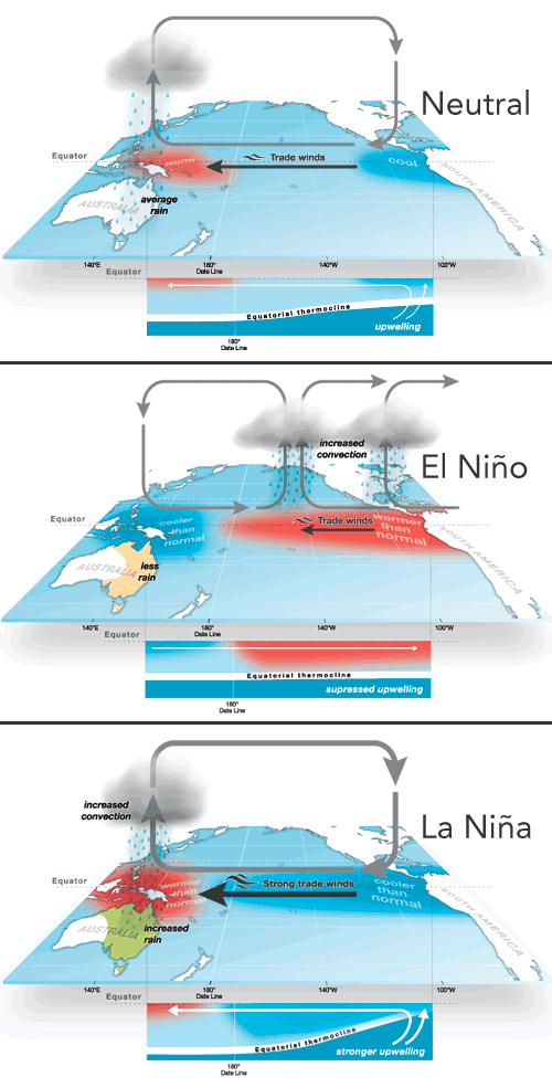
- In order to understand the concept of El Nino, it’s important to be familiar with non-El Nino conditions in the Pacific Ocean.
- Normally, strong trade winds blow westward across the tropical Pacific, the region of the Pacific Ocean located between the Tropic of Cancer and the Tropic of Capricorn.
- Impact on Ocean: El Nino also impacts ocean temperatures, the speed and strength of ocean currents, the health of coastal fisheries, and local weather from Australia to South America and beyond.
- Increased Rainfall: Convection above warmer surface waters brings increased precipitation.
- Rainfall increases drastically in South America, contributing to coastal flooding and erosion.
- Diseases caused by Floods and Droughts: Diseases thrive in communities devastated by natural hazards such as flood or drought.
- El Nino-related flooding is associated with increases in cholera, dengue, and malaria in some parts of the world, while drought can lead to wildfires that create respiratory problems.
- Positive impact: It can sometimes have a positive impact too, for example, El Nino reduces the instances of hurricanes in the Atlantic.
- In South America: As El Nino brings rain to South America, it brings droughts to Indonesia and Australia.
- These droughts threaten the region’s water supplies, as reservoirs dry and rivers carry less water. Agriculture, which depends on water for irrigation, is also threatened.
- In Western Pacific: These winds push warm surface water towards the western Pacific, where it borders Asia and Australia.
- Due to the warm trade winds, the sea surface is normally about 0.5 meter higher and 4-5° F warmer in Indonesia than Ecuador.
- The westward movement of warmer waters causes cooler waters to rise up towards the surface on the coasts of Ecuador, Peru, and Chile. This process is known as upwelling.
- Upwelling elevates cold, nutrient-rich water to the euphotic zone, the upper layer of the ocean.
Previous El Nino Events:
- El Nino events of 1982-83 and 1997-98 were the most intense of the 20th century.
- During the 1982-83 event, sea surface temperatures in the eastern tropical Pacific were 9-18° F above normal.
- The El Nino event of 1997-98 was the first El Nino event to be scientifically monitored from beginning to end.
- The 1997-98 event produced drought conditions in Indonesia, Malaysia, and the Philippines. Peru and California experienced very heavy rains and severe flooding.
- The Midwest experienced record-breaking warm temperatures during a period known as “the year without a winter.”
La Nina
- La Nina means The Little Girl in Spanish. It is also sometimes called El Viejo, anti-El Nino, or simply "a cold event."
- La Nina events represent periods of below-average sea surface temperatures across the east-central Equatorial Pacific.
- It is indicated by sea-surface temperature decreased by more than 0.9℉ for at least five successive three-month seasons.
- La Nina event is observed when the water temperature in the Eastern Pacific gets comparatively colder than normal, as a consequence of which, there is a strong high pressure over the eastern equatorial Pacific.
The Conditions of La Nina.
- La Nina is caused by a build-up of cooler-than-normal waters in the tropical Pacific, the area of the Pacific Ocean between the Tropic of Cancer and the Tropic of Capricorn.
- La Nina is characterized by lower-than-normal air pressure over the western Pacific. These low-pressure zones contribute to increased rainfall.
- La Nina events are also associated with rainier-than-normal conditions over southeastern Africa and northern Brazil.
- However, strong La Nina events are associated with catastrophic floods in northern Australia.
- La Nina is also characterized by higher-than-normal pressure over the central and eastern Pacific.
- This results in decreased cloud production and rainfall in that region.
- Drier-than-normal conditions are observed along the west coast of tropical South America, the Gulf Coast of the United States, and the pampas region of southern South America.
Impact of La Nina
- Europe: In Europe, El Nino reduces the number of autumnal hurricanes.
- La Nina tends to lead to milder winters in Northern Europe (especially UK) and colder winters in southern/western Europe leading to snow in the Mediterranean region.
- North America: It is continental North America where most of these conditions are felt. The wider effects include:
- Stronger winds along the equatorial region, especially in the Pacific.
- Favourable conditions for hurricanes in the Caribbean and central Atlantic area.
- Greater instances of tornados in various states of the US.
- South America: La Nina causes drought in the South American countries of Peru and Ecuador.
- It usually has a positive impact on the fishing industry of western South America.
- Western Pacific: In the western Pacific, La Nina increases the potential for landfall in those areas most vulnerable to their effects, and especially into continental Asia and China.
- It also leads to heavy floods in Australia.
- There are increased temperatures in Western Pacific, Indian Ocean and off the Somalian coast.
La Nina in 2010
- The 2010 La Nina event correlates with one of the worst floods in the history of Queensland, Australia.
- More than 10,000 people were forced to evacuate, and damage from the disaster was estimated at more than $2 billion.
ENSO and India
- El Nino: Strong El Nino events contribute to weaker monsoons and even droughts in India Southeast Asia.
- La Nina: The cold air occupies a larger part of India than the El Nino cold air.
- In the ‘La Nina year’, rainfall associated with the summer monsoon in Southeast Asia tends to be greater than normal, especially in northwest India and Bangladesh.
- This generally benefits the Indian economy, which depends on the monsoon for agriculture and industry.
- It usually brings in colder than normal winters in India.
- La Nina influences the Indian subcontinent by piping in cold air from Siberia and South China, which interacts with the tropical heating to produce a north-south low-pressure system.
- The cold air of La Nina associated with this north-south trough tends to extend much further south into India.
- This is remarkably different from the more northwest-southeast blast of cold air associated with El Nino.
- The pressure pattern going north-south means lesser impact of western disturbances.
- The cold temperature can go down as far as Tamil Nadu, but may not affect the North East that much.