Uttar Pradesh
Ancient River Unearthed in Ganga-Yamuna Doab
- 09 Sep 2025
- 2 min read
Why in News?
A major aquifer mapping project under the National Mission for Clean Ganga (Namami Gange) in Prayagraj has uncovered a long-lost ancient river in the Ganga-Yamuna Doab, stretching between Prayagraj and Kanpur.
Key Points
- About: The paleo-channel mapping revealed the river spans around 200 kilometres in length, about 4 kilometres in width, and 15 to 25 metres in depth.
- Method: Satellite imagery and geospatial data were used to trace the river’s ancient route and map subsurface water reservoirs.
- Potential: The ancient river has a water storage potential of nearly 3,500–4,000 million cubic meters (MCM).
Aquifer Mapping Project
- About: The aquifer mapping project, supported by cutting-edge technologies such as smart water management systems, remote sensing, and drone-based monitoring, is playing a crucial role in the sustainable rejuvenation of the Ganga.
- Implementation: The project is being carried out in collaboration with the Uttar Pradesh State Groundwater and Irrigation Department.
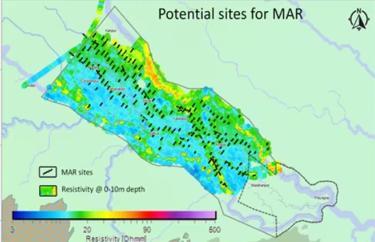
- Managed Aquifer Recharge (MAR) Sites: Over 150 MAR sites have been identified, where recharge structures will be constructed to boost groundwater levels and maintain the river’s baseflow.
- Phases: The project’s first phase will focus on developing 20-25 MAR sites. These recharge structures, each measuring 5m × 5m × 3m, are designed to improve groundwater levels, supporting the flow of water in the river.
- Technology: With the installation of automatic water-level indicators by the Council of Scientific & Industrial Research, National Geophysical Research Institute (CSIR-NGRI), real-time scientific monitoring will ensure the success of the recharge efforts.
- Significance: These initiatives aim to mitigate climate change and water scarcity while preserving the Ganga and other rivers for future generations, providing long-term solutions through subsurface reservoir systems and advanced technologies.