Geography
Tropical Cyclone: Cristobal
- 04 Jun 2020
- 4 min read
Why in News
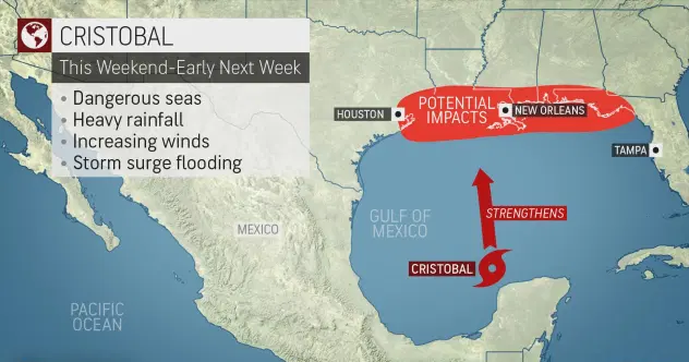
- Recently, a tropical Cyclone named Cristobal has formed in the southern Gulf of Mexico.
Key Points
- Atlantic Hurricane Season:
- Tropical cyclones in the North Atlantic are called hurricanes, tropical storms, or tropical depressions.
- The Atlantic hurricane season is the period in a year when hurricanes usually form in the Atlantic Ocean.
- In the Northern Atlantic Ocean, a distinct hurricane season occurs from June 1 to November 30, sharply peeking from late August through September.
- Worldwide, tropical cyclone activity peaks in late summer, when the difference between temperatures is large and sea surface temperatures is the greatest.
- Favourable Conditions in Gulf Of Mexico:
- Sea surface temperature is generally very high in southwestern Gulf of Mexico, which is to allow the system to strengthen.
- Wind shear i.e. the increase in wind speed with height in the atmosphere, or a sharp change in wind direction, is low as the storm emerges over open water and begins its northward
- The low wind shear favors strengthening of the system even if interaction with Mexico first weakens the storm.
Gulf of Mexico
- The Gulf of Mexico is an ocean basin and a marginal sea of the Atlantic Ocean, largely surrounded by the North American continent.
- It is bounded on the northeast, north and northwest by the Gulf Coast of the United States, on the southwest and south by Mexico, and on the southeast by Cuba.
Tropical Cyclone
- Tropical cyclones are violent storms that originate over oceans in tropical areas and move over to the coastal areas bringing about large scale destruction due to violent winds, very heavy rainfall (torrential rainfall) and storm surge.
- They are irregular wind movements involving closed circulation of air around a low pressure center.
- Conditions Favourable for Tropical Cyclone Formation:
- Large sea surface with temperature higher than 27°C: Ocean waters having temperatures of 27° C or more is the source of moisture which feeds the storm.The condensation of moisture releases enough latent heat of condensation to drive the storm.
- Presence of the Coriolis force: The Coriolis force is zero at the equator (no cyclones at equator because of zero Coriolis Force) but it increases with latitude.
- Coriolis force at 5° latitude is significant enough to create a storm.
- About 65% of cyclonic activity occurs between 10° and 20° latitude.
- The rotation of the earth about its axis affects the direction of the wind. This force is called the Coriolis force.
- Weak low-pressure area: Small local differences in the temperature of water and of air produce various low pressure centers of small size.
- A weak cyclonic circulation develops around these areas.
- High humidity: Such conditions exist over the equatorial doldrums, especially in western margins of oceans (this is because of east to west movement of ocean currents), which have great moisture carrying capacity because the trade winds continuously replace the saturated air.
- Doldrums: Known to sailors around the world as the doldrums, the Inter-Tropical Convergence Zone, (ITCZ) is a belt around the Earth extending approximately five degrees north and south of the equator. Here, the prevailing trade winds of the northern hemisphere blow to the southwest and collide with the southern hemisphere’s driving northeast trade winds.


