Geography
Tectonic Evolution of Greater Maldive Ridge
- 18 Feb 2022
- 8 min read
For Prelims: Greater Maldive Ridge, Tectonic Plate, Moho Discontinuity, Isostasy, Transform Fault, seismic waves.
For Mains: Important Geophysical Phenomena, Earthquakes, Volcanoes, Geographical Features and their Location, Evolution of Continents and Plate Tectonics.
Why in News?
In a recent study, an Indian researcher traced the tectonic evolution and the nature of the Greater Maldive Ridge (GMR).
- It is a very crucial geodynamic feature in the western Indian Ocean whose origin has been the centre of many a scientific debate.
- The study was conducted by the Indian Institute of Geomagnetism, Mumbai, an autonomous institute of the Department of Science & Technology, Govt. of India.
What is a Tectonic Plate?
- A tectonic plate (also called lithospheric plate) is a massive, irregularly-shaped slab of solid rock, generally composed of both continental and oceanic lithosphere.
- The lithosphere includes the crust and top mantle with its thickness range varying between 5-100 km in oceanic parts and about 200 km in the continental areas.
- The concept of Tectonic Plates was first introduced in 1967.
- A tectonic plate may be a continental plate or an oceanic plate, depending on which of the two occupies the larger portion of the plate.
- The Pacific plate is largely an oceanic plate whereas the Eurasian plate is a continental plate.
- The tectonic plates are not fixed but constantly move horizontally over the Asthenosphere as rigid units.
- Sometimes these plates collide, move apart, or slide next to each other which leads to Earthquakes or Volcanic Eruptions.
What is a Mid-Ocean Ridge?
- A mid-ocean ridge or mid-oceanic ridge is an underwater mountain range, formed by plate tectonics.
What is the Mohorovičić Discontinuity?
- The Mohorovicic Discontinuity, or "Moho," is the boundary between the crust and the mantle. The red line in the diagram shows its location.
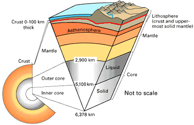
- In geology the word "discontinuity" is used for a surface at which seismic waves change velocity.
- One of these surfaces exists at an average depth of 8 kilometres beneath the ocean basin and at an average depth of about 32 kilometres beneath the continents.
- At this discontinuity, seismic waves accelerate. This surface is known as the Mohorovicic Discontinuity or often simply referred to as the "Moho."
- The Mohorovicic Discontinuity was discovered in 1909 by Andrija Mohorovicic, a Croatian seismologist.
What is the Greater Maldive Ridge?
- The Maldive Ridge is an aseismic ridge that is not associated with earthquake activities. This ridge, located in the western Indian Ocean, southwest of India, is not well investigated.
- It is of paramount importance to gain knowledge on the structure and geodynamics of aseismic ridges (as it provides valuable inputs towards understanding the evolution of ocean basins).
What is the Study About?
- It has chalked the possible geological cross-sections along the GMR for the first time with the help of satellite-derived high-resolution gravity data.
- Satellite-derived gravity anomalies are very helpful in deciphering the crustal architecture where traditional shipborne geophysical data are either not available or scanty.
- The researchers postulated that the GMR may be underlain by an oceanic crust.
- It provides the crustal architecture and the state of gravitational equilibrium between Earth's crust and mantle (isostasy) of the Greater Maldive Ridge segment of the larger Chagos-Laccadive Ridge (CLR) system.
- Isostasy is the rising or settling of a portion of the Earth's lithosphere that occurs when weight is removed or added in order to maintain equilibrium between buoyancy forces that push the lithosphere upward and gravity forces that pull the lithosphere downward.
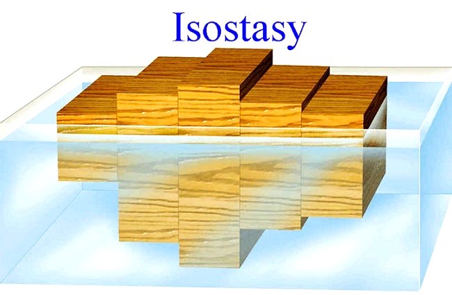
- Isostasy is the rising or settling of a portion of the Earth's lithosphere that occurs when weight is removed or added in order to maintain equilibrium between buoyancy forces that push the lithosphere upward and gravity forces that pull the lithosphere downward.
- Their study, based mainly on the interpretation of gravity anomalies (small differences in the pull of gravity caused by the lateral variations of density within the subsurface) with broadband seismic and refraction seismic data, provided for the first time a three-dimensional picture of the variation of Moho along the Greater Maldive Ridge and the adjoining ocean basins.
- The depth to the boundary between the earth’s crust and the mantle or the Mohorovicic discontinuity (Moho) over the GMR was systematically mapped along with the finer variation of effective elastic thickness (Te) at the place.
- The study found that Moho is deeper over the MR segment and shallows southwards in the Deep Sea Channel region (DSC).
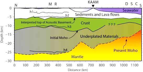
- However, the effective elastic thickness (a proxy for the strength of the lithosphere) values were lower over the MR compared to the DSC region.
- The MR and DSC region may probably be oceanic in nature with the presence of underplated materials associated with the Reunion hotspot volcanism.
- Most of the volcanic activities are concentrated along or adjacent to plate boundaries, but there are some important exceptions in which this activity occurs within plates, called the Hotspots.
- There are about 40 to 50 hot spots estimated to be around the world.
- The research suggests that MR might have formed in the close vicinity of the Mid-Oceanic Ridge (where creation of a new ocean floor occurs due to divergent motion of lithospheric plates or spreading centre).
- Meanwhile, the DSC region was under a long transform fault (offset between the spreading centres, which neither create nor destroy lithosphere), which hindered melt production and gave rise to the gap between Chagos and MR during the Plume-ridge interaction.
- A mantle plume is an area under the crust of Earth, where magma is hotter than surrounding magma.
- A transform fault, in geology and oceanography, is a type of fault in which two tectonic plates slide past one another.
What is the Significance of the Study?
- The study can help reconstruct the original Gondwanaland break up and dispersal that led to present-day configuration of continents, continental fragments, and formation of ocean basins in the Indian Ocean.
- The results from their study can provide additional constraints in understanding the plate-tectonic evolution of the Indian Ocean, better.


