Geography
Land of Fire and Ice: Iceland
- 25 Dec 2023
- 7 min read
For Prelims: Mid-Atlantic Ridge, Atlantic Ocean,Eyjafjallajökull, Oceanic crust,Tectonic Plates, Pacific Ring of Fire, Earth's subduction zones, Pacific Ocean, Kamchatka Peninsula, Southeast Asia, Himalayan Mountain system,Alps mountains, Mediterranean Sea, Aegean Sea, IAS, UPSC.
For Mains: Volcanoes and Its Worldwide Distribution
Why in News?
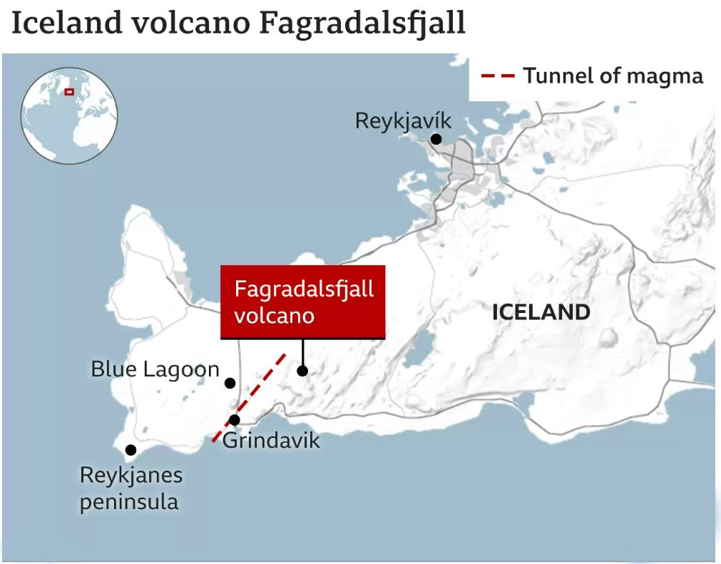
Recently, the Government of Iceland has confirmed that the volcanic eruption near the capital Reykjanes poses no threat to human life.
- Iceland is located on thes Mid-Atlantic Ridge, technically the longest mountain range in the world, but on the floor of the Atlantic Ocean.
- The eruption began between Sýlingarfell and Hagafell, just north of the fishing town of Grindavik which is located on the Reykjanes Peninsula.
What are the Key Facts about Iceland (Land of Fire and Ice)?
- Iceland is located on the Mid-Atlantic Ridge, technically the longest mountain range in the world, but on the floor of the Atlantic Ocean.
- The ridge separates the Eurasian and North American tectonic plates making it a hotbed of seismic activity. It is mostly a submarine, running along the length of the Atlantic from north to south.
- However, in the North Atlantic, it rises over the ocean surface in the form of the island of Iceland. This feature of its geology has given rise to Iceland’s unique landscape made up of geysers (hot springs), glaciers, mountains, volcanoes and lava fields.
- Iceland is home to 33 active volcanoes, the highest in Europe. This unique landscape has given Iceland the epithet, ‘Land of Fire and Ice’.
- Eyjafjallajökull, one of Iceland's most famous volcanoes, erupted in 2010, causing a widespread ash cloud.
- Other notable volcanoes include Hekla, Grímsvötn, Hóluhraun, and Litli-Hrútur, part of the Fagradalsfjall system.
- Eyjafjallajökull, one of Iceland's most famous volcanoes, erupted in 2010, causing a widespread ash cloud.
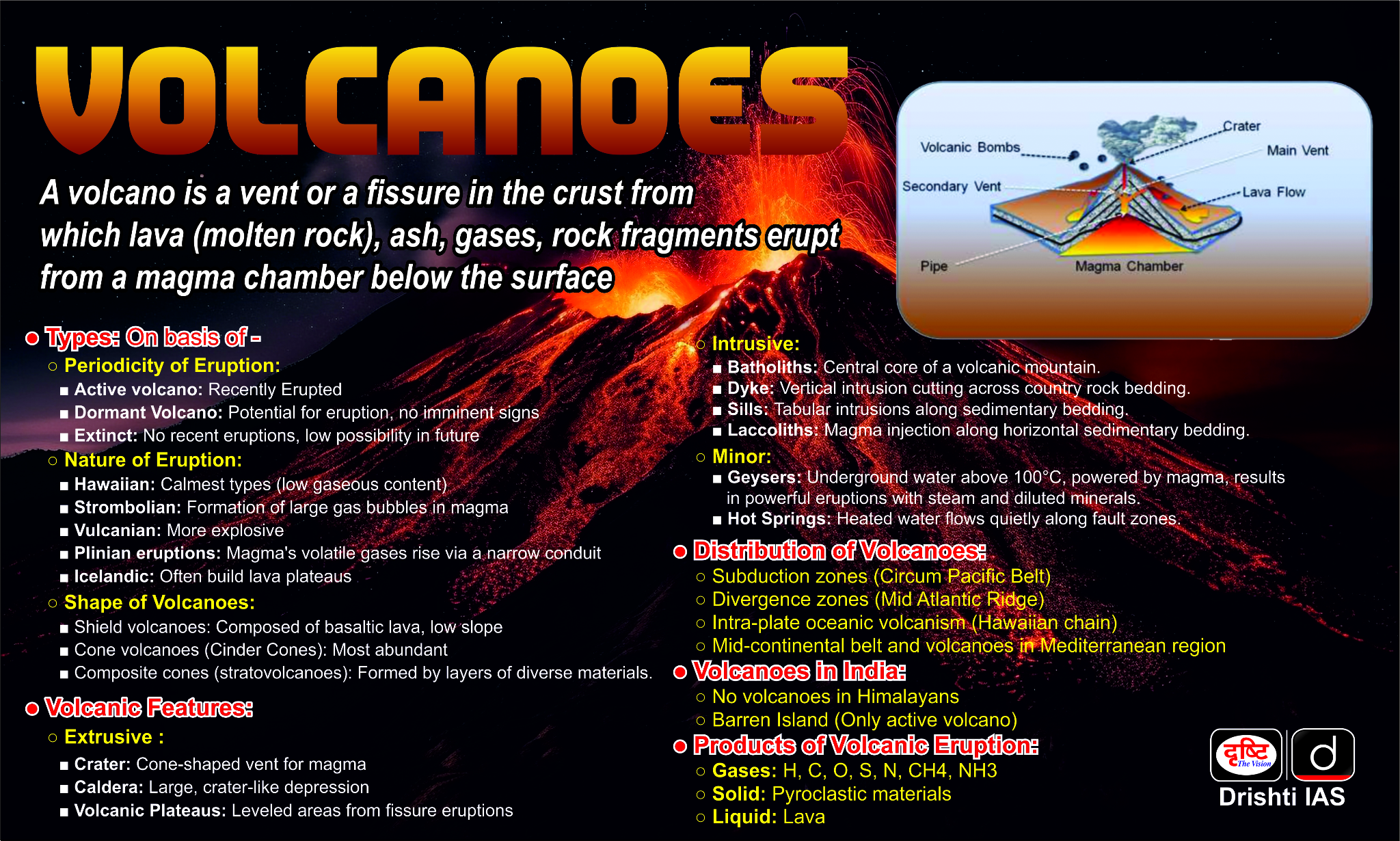
What are the Other Volcano-Prone Regions in the World?
- Volcanoes are distributed all around the world, mostly along the edges of Tectonic Plates, although there are intraplate volcanoes that form from mantle Hotspots .
- Circum-Pacific Belt:
- The Pacific "Ring of Fire" is a string of volcanoes and sites located on most of the Earth's subduction zones having high seismic activity, around the edges of the Pacific Ocean.
- The Pacific Ring of Fire has a total of 452 volcanoes.
- Most of the active volcanoes are found on its western edge, from the Kamchatka Peninsula in Russia, through the islands of Japan and Southeast Asia, to New Zealand.
- Mid-Continental Belt:
- This volcanic belt extends along the Alpine Mountain system of Europe, North America, through Asia Minor, Caucasia, Iran, Afghanistan and Pakistan to the Himalayan Mountain system, including Tibet, the pamir, Tien-Shan, Altai, and the mountains of China, Myanmar and eastern Siberia.
- This belt includes the volcanoes of Alps mountains, Mediterranean Sea (Stromboli, Vesuvius, Etna, etc.), volcanoes of Aegean Sea, Mt. Ararat (Turkey), Elburz, Hindu Kush and Himalayas.
- Mid Atlantic Ridge:
- The Mid-Atlantic Ridge separates the North and South American Plate from the Eurasian and African Plate.
- Magma rises through the cracks and leaks out onto the ocean floor like a long, thin, undersea volcano. As magma meets the water, it cools and solidifies, adding to the edges of the sideways-moving plates.
- This process along the divergent boundary has created the longest topographic feature in the form of Mid oceanic ridges under the Oceans of the world.
- Intraplate Volcanoes:
- The 5% of known volcanoes in the world that are not closely related to plate margins are generally regarded as intraplate, or “hot-spot,” volcanoes.
- A hot spot is believed to be related to the rising of a deep-mantle plume, which is caused by very slow convection of highly viscous material in Earth’s mantle.
- It can be represented by a single oceanic volcano or lines of volcanoes such as the Hawaiian-Emperor seamount chains.
- The 5% of known volcanoes in the world that are not closely related to plate margins are generally regarded as intraplate, or “hot-spot,” volcanoes.
UPSC Civil Services Examination, Previous Year Question
Prelims
Q. Consider the following statements: (2018)
- The Barren Island volcano is an active volcano located in the Indian territory.
- Barren Island lies about 140 km east of Great Nicobar.
- The last time the Barren Island volcano erupted was in 1991 and it has remained inactive since then.
Which of the statements given above is/are correct?
(a) 1 only
(b) 2 and 3
(c) 3 only
(d) 1 and 3
Ans: (a)
- Barren Island is India’s only active volcano which is located in the Andaman and Nicobar Islands. Hence, statement 1 is correct.
- It is located at about 140 km from Port Blair, southern part of Andaman Island in Andaman Sea. The distance between Barren Island to Great Nicobar is more than the given distance. Hence, statement 2 is not correct.
- First recorded eruption of the volcano dates back to 1787. In the past 100 years, it has erupted at least five times. Then for the next 100 years, it remained silent. It re-erupted massively in 1991.
- Since then, the eruption has been recorded every two-three years; the latest in the series was February 2016. Hence, statement 3 is not correct. Therefore, option (a) is the correct answer.
Mains
Q. Discuss the geophysical characteristics of Circum-Pacific Zone. (2020)
Q. Mention the global occurrence of volcanic eruptions in 2021 and their impact on the regional environment. (2021)


