International Relations
India-Nepal Border Dispute
- 23 May 2020
- 8 min read
Why in News
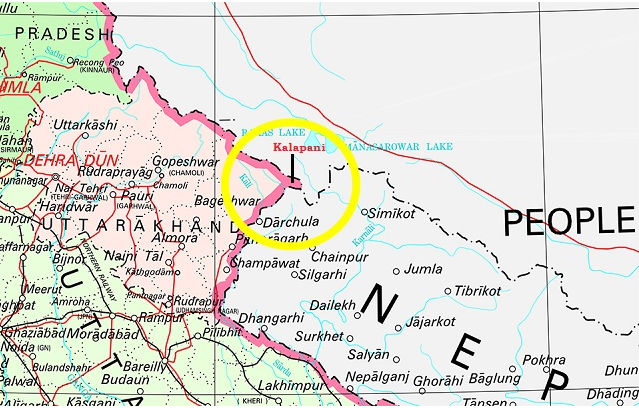
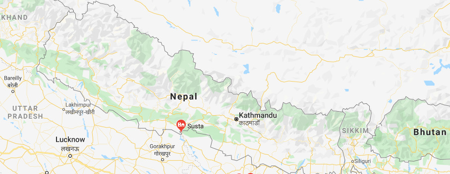
Recently, Nepal has released a new political map that claims Kalapani, Limpiyadhura and Lipulekh of Uttarakhand as part of Nepal’s territory. The area of Susta (West Champaran district, Bihar) can also be noted in the new map.
Key Points
- India rejected the new map of Nepal saying that Nepal's new map involves artificial enlargement of territories, which is not based on historical facts and evidence.
- Nepal’s act is an unilateral act and is contrary to the bilateral understanding to resolve the outstanding boundary issues through diplomatic dialogue.
- India has urged the Government of Nepal to refrain from such an unjustified cartographic assertion and respect India’s sovereignty and territorial integrity.
- India has also asked Nepal to return to dialogue.
- Nepal’s move came after India’ Defence Minister recently inaugurated a motorable link road that connects India and China, significantly reducing the time of Kailash Mansarovar Yatra.
- The road passes through territory at the Lipulekh pass that Nepal claims as its own territory.
- Earlier, Nepal had protested strongly against India, when India published a new map which showed the region of Kalapani as part of the Indian territory.
- Nepal had also expressed displeasure on the 2015 agreement between India and China for using the Lipulekh pass for trade, without consulting Nepal.
Border Dispute Between India and Nepal
- Currently, India and Nepal have border disputes over Kalapani - Limpiyadhura - Lipulekh trijunction between India-Nepal and China and Susta area (West Champaran district, Bihar).
- Kalapani Region:
- Kalapani is a valley that is administered by India as a part of the Pithoragarh district of Uttarakhand. It is situated on the Kailash Mansarovar route.
- Kalapani is advantageously located at a height of over 20,000 ft and serves as an observation post for that area.
- The Kali River in the Kalapani region demarcates the border between India and Nepal.
- The Treaty of Sugauli signed by the Kingdom of Nepal and British India (after Anglo-Nepalese War) in 1816 located the Kali River as Nepal's western boundary with India.
- The discrepancy in locating the source of the Kali river led to boundary disputes between India and Nepal, with each country producing maps supporting their own claims.
- Kalapani is a valley that is administered by India as a part of the Pithoragarh district of Uttarakhand. It is situated on the Kailash Mansarovar route.
- Susta Region:
- The change of course by the Gandak river is the main reason for disputes in the Susta area.
- Susta is located on the bank of the Gandak river.
- It is called Narayani river in Nepal.
- It joins Ganga near Patna, Bihar.
- Nepal’s Stand:
- Kali river originates from a stream at Limpiyadhura, north-west of Lipu Lekh. Thus Kalapani, and Limpiyadhura, and Lipu Lekh, fall to the east of the river and are part of Nepal’s Dharchula district.
- Lipulekh was deleted from the country’s map by the kings to get favours from India.
- The territory of Kalapani was offered to India by King Mahendra after the 1962 India-China war who wanted to help India’s security concerns due to perceived lingering Chinese threats.
- Kalapani was not a part of Nepal-India dispute. It was Nepal’s territory that the king had allowed India to use temporarily
- The new map is in fact a document that was in circulation in Nepal till the 1950s.
- India’s Stand:
- Kali river originates in springs well below the Lipu-lekh pass, and the Sugauli Treaty does not demarcate the area north of these streams.
- The administrative and revenue records of the nineteenth century also show that Kalapani was on the Indian side, and counted as part of Pithoragarh district of Uttarakhand.
- Efforts to Solve Border Dispute:
- In the 1980s, the two sides set up the Joint Technical Level Boundary Working Group to delineate the boundary.
- The group demarcated everything except Kalapani and Susta area.
- Officially, Nepal brought the issue of Kalapani before India in 1998. Both sides agreed to demarcate the outstanding areas (including Kalpani) by 2002 at the prime ministerial level talk held in 2000. But that has not happened yet.
- In the 1980s, the two sides set up the Joint Technical Level Boundary Working Group to delineate the boundary.
- Issues Involved:
- Nepal's deliberate effort to make the Lipu-Lekh Pass a disputed tri-junction (between India-China and Nepal) in which Nepal has an equal share.
- India perceives Nepal to be tilting towards China under the leadership of Prime Minister K P Oli and his Nepal Communist Party.
- Despite the open border between both countries and the people to people contact, the levels of distrust in Nepal about India have only increased.
Way Forward
- Given the importance of ties with Nepal, often romanticised as one of “roti-beti” (food and marriage), India must not delay dealing with the matter, and at a time when it already has a faceoff with China in Ladakh and Sikkim.
- Since the free movement of people is permitted across the border, Nepal enjoys immense strategic relevance from India’s national security point of view, as terrorists often use Nepal to enter India.
- Therefore, stable and friendly relations with Nepal is one of prerequisites which India can’t afford to overlook.
- India should also try to convey to Nepal’s leadership about the congenial and friendly environment that 6 to 8 million Nepali citizens living in India enjoy.
- Therefore, Any thoughtless erosion of this centuries old togetherness may prove difficult for both countries.
- The existing bilateral treaties between India and Nepal have not taken the shifting of Himalayan rivers into consideration. A primary reason for this is the lack of an approach where ecological concerns and needs of rivers are often discussed.
- Therefore, India and Nepal should try to resolve the boundary dispute by taking into account all shared environmental characteristics.


