Biodiversity & Environment
Green Wall of India
- 10 Oct 2019
- 5 min read
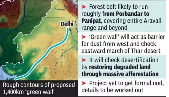
The Centre is mulling an ambitious plan to create a 1,400km long and 5km wide green belt from Gujarat to the Delhi-Haryana border.
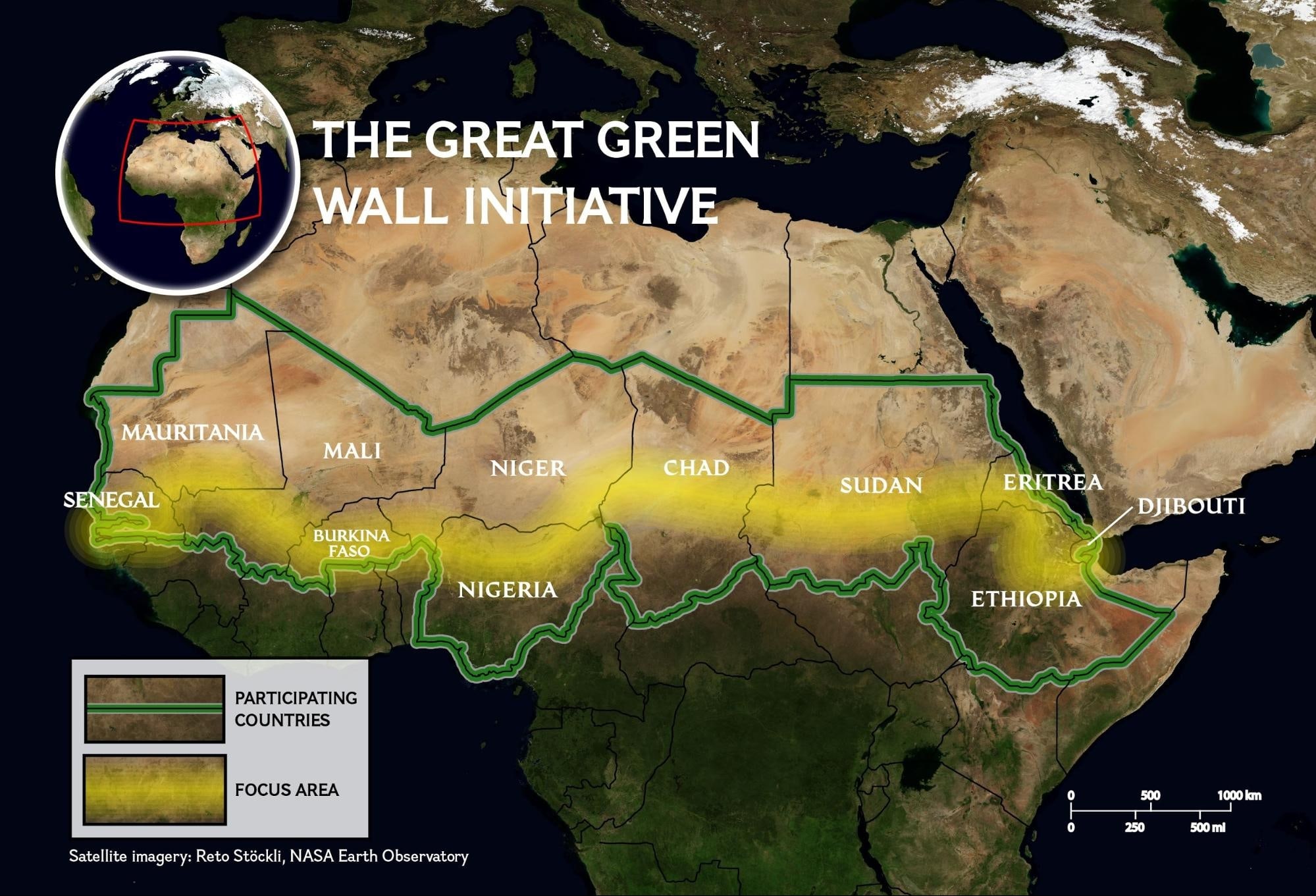
- The plan is inspired by Africa’s ‘Great Green Wall’ project, running from Senegal (West) to Djibouti (East), which came into effect in 2007.
- The overarching objective of India’s Green Wall will be to address the rising rates of land degradation and the eastward expansion of the Thar desert.
- The green belt being planned from Porbandar to Panipat will help in restoring degraded land through afforestation along the Aravali hill range. It will also act as a barrier for dust coming from the deserts in western India and Pakistan.
- The Aravali has been identified as one of the key degraded zones to be taken up for greening under India’s target to restore 26 million hectares (mha) of its land.
- A 2016 report from the Indian Space Research Organisation (ISRO) had also indicated that Delhi, Gujarat and Rajasthan had already degraded over 50% of their land.
Great Green Wall of Africa
- It aims to restore Africa’s degraded landscapes and transform millions of lives in one of the world’s poorest regions, the Sahel.
- The African initiative is still only 15% complete.
- Once fully completed, the Wall will be the largest living structure on the planet – an 8,000 km natural wonder of the world stretching across the entire width of the continent.
- African countries during the UNCCCD COP14 sought global support in terms of finance to make the Wall a reality in the continent’s Sahel region by 2030.
- Sahel is a semiarid region of western and north-central Africa extending from Senegal eastward to Sudan.
- It forms a transitional zone between the arid Sahara (desert) to the north and the belt of humid savannas to the south.
Aravali Mountain Range
- The Aravallis, is the oldest fold mountains on Earth. Geological studies show its age as three billion years.
- It spans over 800km from Gujarat to Delhi (through Rajasthan and Haryana).
- The highest peak in the Aravalli Range is Guru Peak on Mount Abu.
- Influences Climate:
- The Aravallis have an impact upon the climate of northwest India and beyond.
- During monsoons, the mountain range gently guides the monsoon clouds eastwards towards Shimla and Nainital, thus helping nurture the sub-Himalayan rivers and feeding the north Indian plains.
- In the winter months, it protects the fertile alluvial river valleys (the para-Indus and Gangetic) from the assault of cold westerly winds from Central Asia.
- Concerns:
- The Aravalli range, which separates western India’s Thar desert from the relatively green plains to its east, has lost so much green cover that it is losing its ability to act as a natural barrier against the heat and dust that blows in from the west.
- The Thar desert’s expansion could threaten the “granary of India"—the fertile belts of Punjab, Haryana, western Uttar Pradesh and the Malwa region.
- Unauthorized mining for minerals and building materials has vanished some hills in the region.
- The Aravalli range, which separates western India’s Thar desert from the relatively green plains to its east, has lost so much green cover that it is losing its ability to act as a natural barrier against the heat and dust that blows in from the west.
Thar Desert
- The Thar Desert also called the Great Indian desert lies towards the western margins of the Aravali Hills.
- It is an undulating sandy plain covered with sand dunes (mainly Barchans).
- Barchans are crescent-shaped sand dune always facing the wind. It is formed when a lot of sand is present in the desert. A steady wind from one direction is also needed.
- The region receives very low rainfall below 150 mm per year.
- It has an arid climate with low vegetation cover.
- Luni is the only large river in this region.


