Geography
Coastal Vulnerability Index
- 10 Feb 2022
- 3 min read
For Prelims: Coastal Vulnerability, CVI, Sea Level Rise, INCOIS, Coastal Multi-Hazard Vulnerability Mapping.
For Mains: Disaster Management, Environmental Pollution & Degradation, Coastal Vulnerability Index and Its Significance.
Why in News?
Recently, the Indian National Centre for Ocean Information Services (INCOIS) has carried out a coastal vulnerability assessment for the entire Indian coast at States level.
- The assessment has been conducted to bring out an Atlas comprising 156 maps on 1:1,00,000 scales to prepare a Coastal Vulnerability Index (CVI).
What is Coastal Vulnerability?
- Coastal vulnerability is a spatial concept that identifies people and places that are susceptible to disturbances resulting from coastal hazards.
- Hazards in the coastal environment, such as coastal storms, sea level rise and erosion, pose significant threats to coastal physical, economic, and social systems.
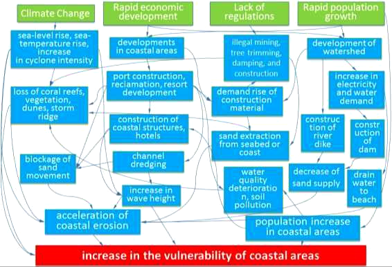
What is the Coastal Vulnerability Index?
- The maps will determine the coastal risks due to future sea-level rise based on the physical and geological parameters for the Indian coast.
- The CVI uses the relative risk that physical changes will occur as sea-level rises are quantified based on parameters like:
- Tidal range
- Wave height
- Coastal slope
- Coastal elevation
- Shoreline change rate
- Geomorphology
- Historical rate of relative sea-level change.
What is a Coastal Multi-Hazard Vulnerability Mapping?
- A coastal Multi-Hazard Vulnerability Mapping (MHVM) was also carried out using above mentioned parameters.
- These parameters were synthesised to derive the composite hazard zones that can be inundated along the coastal low-lying areas due to extreme flooding events.
- This MHVM mapping was carried for the entire mainland of India on a 1:25000 scale.
What is the Significance of CVI?
- Coastal vulnerability assessments can be useful information for coastal disaster management and building resilient coastal communities.
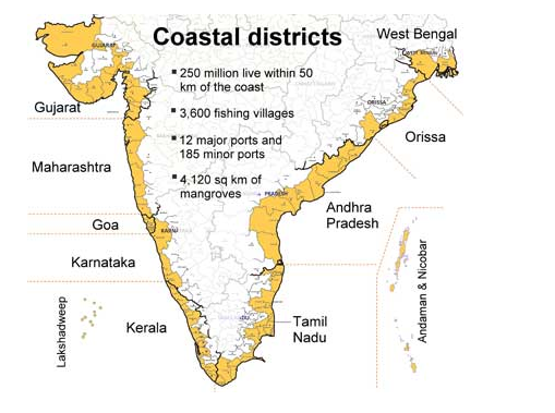
- India has a coastline of 7516.6 Km i.e. 6100 km of mainland coastline plus coastline of 1197 Indian islands touching 13 States and Union Territories (UTs).
What is INCOIS?
- INCOIS is an autonomous organisation under the Ministry of Earth Sciences (MoES).
- It is located in Hyderabad & was established in 1999. It is a unit of the Earth System Science Organisation (ESSO), New Delhi.
- The ESSO operates as an executive arm of the Ministry of Earth Sciences (MoES) for its policies and programmes.
- It is mandated to provide the best possible ocean information and advisory services to society, industry, government agencies and the scientific community through sustained ocean observations and constant improvement through systematic and focused research.


