International Relations
China Releases a Map Asserting Territorial Claims
- 30 Aug 2023
- 10 min read
For Prelims: Aksai Chin Region, Nine-Dash Line, China-Pakistan Economic Corridor (CPEC), Line of Actual Control (LAC).
For Mains: China Releases a Map Asserting Territorial Claims, its implications on India.
Why in News?
China's government recently unveiled the "2023 edition of the standard map of China," reaffirming its territorial claims over disputed regions.
- The release of the map coincides with China's "National Mapping Awareness Publicity Week," which emphasizes the significance of accurate and consistent mapping.
What are the China's Claims in the New Map?
- Territorial Claims:
- The map incorporates China's territorial claims, encompassing Arunachal Pradesh and the Aksai Chin Region.
- These claims have long been points of contention between China and India.
- The map also features the "Nine-Dash Line," a contentious demarcation that covers the entire South China Sea and underscores Beijing's claims over this strategic maritime region.
- The map also shows the tenth dash line which underlines Beijing’s claims over Taiwan island.
- The map incorporates China's territorial claims, encompassing Arunachal Pradesh and the Aksai Chin Region.
- Renaming of Places:
- China's release of the new map aligns with its previous actions, such as standardizing the names of places in Arunachal Pradesh, including areas close to the state capital.
- Digital Mapping:
- Apart from the physical map, China is set to release digital maps for various applications, including location-based services, precision agriculture, platform economy, and intelligent connected vehicles.
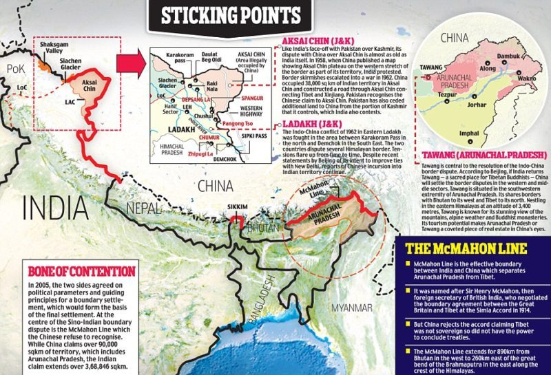
What is the Point of Contention Between India-China Border?
- Background:
- The India-China border dispute refers to the long-standing and complex territorial disputes along their shared border of 3,488 kilometers.
- The main areas of dispute are Aksai Chin, located in the western sector, and Arunachal Pradesh, in the eastern sector.
- Aksai Chin: China administers Aksai Chin as part of its Xinjiang region, while India considers it part of its union territory of Ladakh. The region holds strategic significance due to its proximity to the China-Pakistan Economic Corridor (CPEC) and its potential as a military route.
- Arunachal Pradesh: China claims the entire state of Arunachal Pradesh, referring to it as "South Tibet." India administers this region as a northeastern state and considers it an integral part of its territory.
- No Clear Demarcation: The border between India and China is not clearly demarcated throughout and there is no mutually agreed Line of Actual Control (LAC) along certain stretches.
- LAC came into existence after the 1962 Indo-China war.
- The India-China border is divided into three sectors.
- Western Sector: Ladakh
- Middle Sector: Himachal Pradesh and Uttarakhand
- Eastern Sector: Arunachal Pradesh and Sikkim
- Military Standoffs:
- 1962 Sino-Indian War: The border dispute has led to a number of military standoffs and clashes, including the 1962 Sino-Indian War. Both countries have made efforts to manage the tensions, with various agreements and protocols aimed at maintaining peace along the border.
- Recent Faceoffs: The most serious recent episodes of conflict were in Galwan Valley in Ladakh in 2020 and in Tawang in Arunachal Pradesh in 2022.
- Observers on both sides of the border—the Line of Actual Control (LAC)—agree that the number of serious military confrontations has increased since 2013.
What have been the Border Dispute Settlement Mechanisms?
- Shimla agreement of 1914: To demarcate the boundary between Tibet and North East India, a convention was held at Shimla in 1914, representatives of all three i.e. Tibet, China, and British India.
- After the discussion, the agreement was signed by British India and Tibet but not by the Chinese officials. Presently India recognizes but China rejected both the Shimla agreement and the McMahon line.
- Panchsheel Agreement of 1954: The Panchsheel doctrine clearly indicated the willingness to ‘Respect each other’s sovereignty and territorial integrity’.
- The Agreement on the Maintenance of Peace and Tranquility:
- It was signed in 1993, which called for a renunciation of the use of force, recognition of the LAC, and the resolution of the border issue through negotiations.
- The Agreement on Confidence Building Measures in the Military Field along the LAC:
- It was signed in 1996, which laid down pledges on non-aggression, prior notification of large troop movements, and exchange of maps to resolve disagreements over the LAC.
- The Border Defence Co-operation Agreement:
- It was signed in 2013 following the Depsang Valley incident.
What are the Implications of China's New Map on India?
- Territorial Assertion:
- By incorporating disputed territories into its official map, China is reinforcing its territorial claims, challenging India's sovereignty over Arunachal Pradesh and Aksai Chin, and escalating the border dispute.
- By incorporating disputed territories into its official map, China is reinforcing its territorial claims, challenging India's sovereignty over Arunachal Pradesh and Aksai Chin, and escalating the border dispute.
- Diplomatic Tensions:
- China's actions can lead to diplomatic tensions between the two countries. India has consistently rejected China's territorial claims and will likely respond with reaffirmations of its own claims.
- Impact on Bilateral Relations:
- It can strain India-China relations, affecting cooperation in various areas, including trade, investment, and people-to-people exchanges.
- Regional Balance:
- The border dispute has implications for the broader regional balance of power. It can influence India's strategic alignment with other countries and regional groupings to counter China's influence.
How Should India Tackle China's Territorial and Regional Assertiveness?
- Diplomacy and Dialogue:
- Continue engaging in diplomatic talks with China through established mechanisms like the Special Representative talks and Working Mechanism for Consultation and Coordination (WMCC) on India-China border affairs.
- Emphasize peaceful resolution, adherence to bilateral agreements, and the importance of maintaining peace and stability along the border.
- Strengthen Border Infrastructure:
- Invest in improving border infrastructure, including roads, bridges, airstrips, and communication networks, to enhance mobility and response capabilities for Indian forces.
- Develop logistics hubs and forward bases to ensure swift deployment of troops and supplies in the border regions.
- Enhance Military Preparedness:
- Invest in modernizing the armed forces with advanced equipment, technology, and surveillance capabilities to effectively monitor and respond to any border incidents.
- Focus on enhancing the training and readiness of troops stationed in border areas.
- Regional and Global Partnerships:
- Strengthen partnerships with like-minded countries and regional organizations that share concerns about China's assertiveness in territorial disputes.
- Collaborate on intelligence-sharing, joint military exercises, and coordinated responses to regional challenges.
- Economic and Trade Measures:
- Diversify economic ties to reduce dependence on China and enhance economic resilience.
- Explore trade agreements and partnerships with countries that can provide alternative markets and investment opportunities.
- International Forums:
- Raise the border issue at international forums to garner support for a peaceful resolution based on international norms and principles.
- Uphold international norms and principles related to territorial integrity and dispute resolution mechanisms.
- Continue to engage with international legal experts to present India's case on the border issue.
Conclusion
- China's release of the 2023 edition of its standard map reaffirms its territorial claims over disputed areas like Arunachal Pradesh and the Aksai Chin region.
- This move is consistent with China's assertive approach to its borders and geopolitical interests under President Xi Jinping's leadership.
- The map serves as a reflection of China's ongoing efforts to bolster its territorial claims and geopolitical influence in the region.
Related Infographics: India's Border Dispute With Neighbors
UPSC Civil Services Examination, Previous Year Question (PYQ)
Prelims:
Q. Siachen Glacier is situated to the (2020)
(a) East of Aksai Chin
(b) East of Leh
(c) North of Gilgit
(d) North of Nubra Valley
Exp:
- The Siachen Glacier is located in the Eastern Karakoram range in the Himalayas, just northeast of Point NJ9842 where the Line of Control between India and Pakistan ends.
- It has the distinction of being the largest glacier outside the polar and subpolar regions.
- It lies to the west of Aksai Chin, north of Nubra Valley, and almost east of Gilgit.
Therefore, option (d) is the correct answer.
Mains
Q. Border management is a complex task due to difficult terrain and hostile relations with some countries. Elucidate the challenges and strategies for effective border management. (2016).


