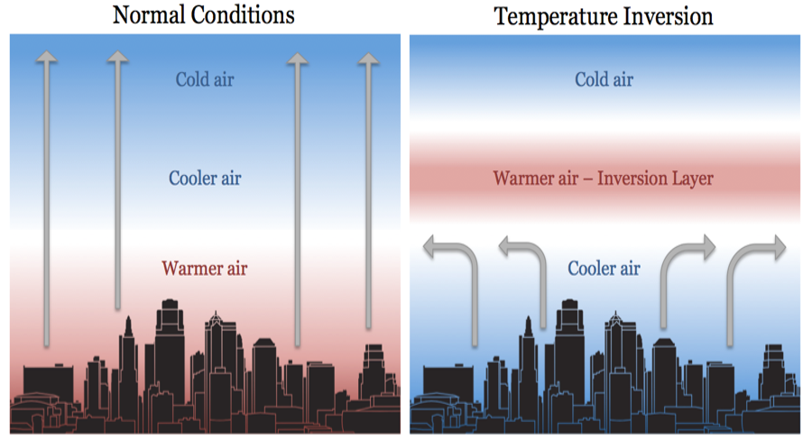
Under normal conditions, temperature usually decreases with increase in altitude in the troposphere at a rate of 1 degree for every 165 metres. This is called normal lapse rate.
But on some occasions, the situations get reversed and temperature starts increasing with height rather than decreasing. This is called temperature inversion.
Temperature inversion: It is a reversal of the normal behavior of temperature in the troposphere. Under this meteorological phenomenon a layer of warm air lies over the cold air layer.
It is caused in stac atmospheric conditions while some times, it occurs due to horizontal or vertical movement of air.
Temperature inversion is usually of short duration but quite common nonetheless.
Favourable Conditions for Temperature Inversion
Long winter nights: Loss of heat by terrestrial radiation from the ground surface during night may exceed the amount of incoming solar radiation.
Cloudless and clear sky: Loss of heat through terrestrial radiation proceeds more rapidly without any obstruction.
Dry air near the ground surface: It limits the absorption of the radiated heat from the Earth’s surface.
Slow movement of air: It results in no transfer or mixing of heat in the lower layers of the atmosphere.
Snow covered ground surface: It results in maximum loss of heat through reflection of incoming solar radiation.
Types of Temperature Inversion
Temperature inversion occurs in several conditions ranging from ground surface to great heights. Thus there are several kinds of temperature inversions.
The following are classified on the basis of relative heights from the earth’s surface at which it occurs and the type of air circulation:
Non-Advectional
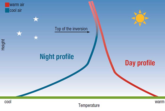
Radiation Inversion (Surface Temperature Inversion)
Surface temperature inversion develops when air is cooled by contact with a colder surface until it becomes cooler than the overlying atmosphere; this occurs most often on clear nights, when the ground cools off rapidly by radiation. If the temperature of surface air drops below its dew point, fog may result.
It is very common in the higher latitudes. In lower and middle latitudes, it occurs during cold nights and gets destroyed during day time.
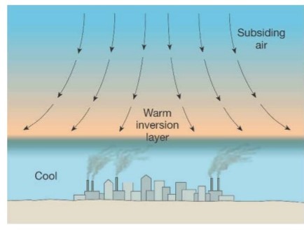
Subsidence Inversion (Upper Surface Temperature Inversion)
When a widespread layer of air descends, it is compressed and heated by the resulting increase in atmospheric pressure, and as a result the lapse rate of temperature is reduced.
The air at higher altitudes becomes warmer than at lower altitudes, producing a temperature inversion. This type of temperature inversion is called subsidence inversion.
It is very common over the northern continents in winter (dry atmosphere) and over the subtropical oceans; these regions generally have subsiding air because they are located under large high-pressure centers.
It is also called upper surface temperature inversion because it takes place in the upper parts of the atmosphere.
Advectional
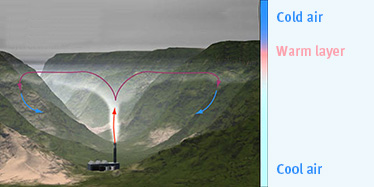
Valley inversion in intermontane valley
In high mountains or deep valleys, sometimes, the temperature of the lower layers of air increases instead of decreasing with elevation along a sloping surface.
Here, the surface radiates heat back to space rapidly and cools down at a faster rate than the upper layers. As a result the lower cold layers get condensed and become heavy.
The sloping surface underneath makes them move towards the bottom where the cold layer settles down as a zone of low temperature while the upper layers are relatively warmer.
This condition, opposite to normal vertical distribution of temperature, is known as Temperature Inversion.
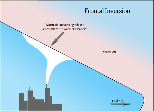
Frontal or Cyclonic inversion
When the warm and cold fronts meet, then the warm front rises up and being heavier the cold front sinks down. It results in formation of Frontal Inversion.
It has considerable slope, whereas other inversions are nearly horizontal. It often takes place in the temperate zone and causes cyclonic conditions which result in the precipitation in different forms.
A frontal inversion is unstable and is destroyed as the weather changes.
Effect
Temperature inversion determines the precipitation, forms of clouds, and also causes frost due to condensation of warm air due to its cooling.
Dust particles hanging in the air: Due to inversion of temperature, air pollutants such as dust particles and smoke do not disperse on the surface.
Stops the movement of air: It causes the stability of the atmosphere that stops the downward and upward movement of air.
Less rainfall: Convection clouds can not move high upwards so there is less rainfall and no showers. So, it causes a problem for agricultural productivity.
Lower visibility: Fog is formed due to the situation of warm air above and cold air below, and hence visibility is reduced which causes disturbance in transportation.
Thunderstorms and tornadoes: Intense thunderstorms and tornadoes are also associated with inversion of temperature because of the intense energy that is released after an inversion blocks an area’s normal convention patterns.
Diurnal variations in temperature tend to be very small.