Geography
India’s Cyclone Preparedness
- 19 Jun 2023
- 14 min read
This editorial is based on Preparedness pays off which was published in The Hindu on 19/06/2023. It talks about the efficacy of preparedness in dealing with cyclone hazard to minimize the losses.
For Prelims: India Meteorological Department (IMD),Cyclone Biparjoy, Indian Ocean Rim Association (IORA), Coastal Regulation Zones (CRZ), Environment Protection Act 1986. Color Coding of Cyclones:
For Mains: National Cyclone Risk Mitigation Project, National Disaster Management Authority (NDMA), Impacts of Cyclone, Mitigation measures.
Cyclone Biparjoy was a very severe cyclonic storm that hit Gujarat and parts of Rajasthan. It caused significant damage to infrastructure, injuries and cattle deaths, but only two human fatalities.
India escaped the worst of the cyclone’s fury due to early warnings from the India Meteorological Department (IMD) and timely evacuation of people from coastal areas. India’s disaster management system has improved over the years; however, the challenges remain for the future.
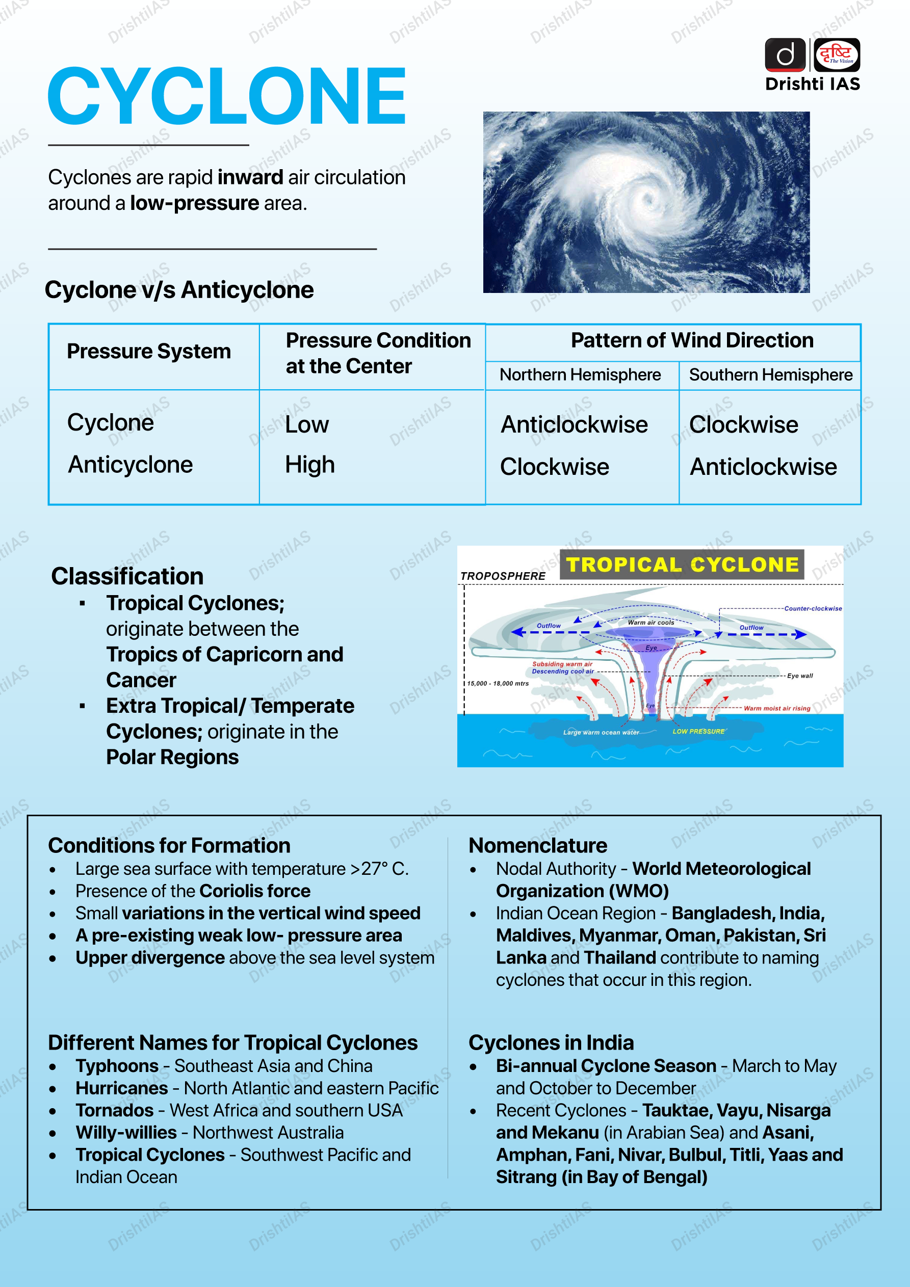
What is a Cyclone?
What are the General Mitigation and Preparedness Measures Against Cyclone?
- Mapping Hazards:
- The mapping of cyclone hazards displays the outcomes of evaluating cyclone risks on a map, indicating the frequency/probability of different intensities or durations.
- Regulating Land Use:
- Implementation of policies to control land use and enforce building codes.
- Vulnerable areas should be kept for parks, grazing grounds or flood diversion instead of human settlements.
- Engineered Structures:
- Some examples of general good construction practice include:
- Constructing buildings on stilts or on earthen mounds.
- Buildings should be wind and water resistant.
- Buildings storing food supplies should be protected against the winds and water.
- Some examples of general good construction practice include:
- Cyclone Shelters:
- People who live in places that often face cyclones need cyclone shelters to protect them.
- Building cyclone shelters is expensive, so they usually depend on the government or outside donors for help.
- The best locations for cyclone shelters can be found using a system that maps the geography of the area.
- Flood Management:
- Cyclonic storms can cause flooding in different ways. The sea water can rise and cover the coastal lands. The rain can be too heavy and fast for the land to absorb.
- Building barriers along the rivers and the coasts can prevent the water from reaching the lands that are prone to flooding.
- The water flow can be controlled by creating places to store water, small dams to slow down water, and other ways to drain water.
- Plantation of Mangroves:
- Mangroves protect the coastal area from storm surge and wind accompanied with cyclones.
- Communities should participate in the mangrove plantation which could be organized by the local authorities, NGOs or the community itself.
- Mangroves also help in erosion-control and coastal conservation.
- Public Awareness Generation:
- Numerous lives can be saved by effectively disseminating information through public education. Research has consistently shown that a lack of public awareness and education contributes significantly to the damage incurred on lives and livelihoods.
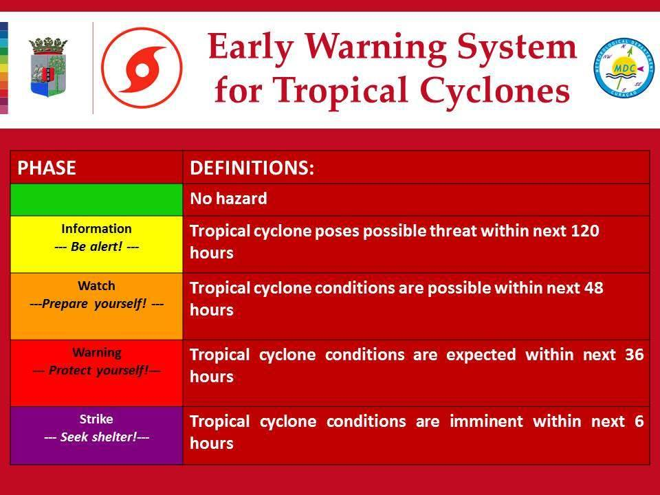
- Early Warning System:
- Enhancing Early Warning Systems to Facilitate Rapid and Efficient Response
- Fostering Awareness and Accessibility of Cyclone Early Warning Signals
- Promoting Information Dissemination Channels for Cyclone Early Warnings
- Community Participation:
- Since the local people are the persons best aware of the strengths and weaknesses of their area, location, culture and customs, some mitigation measures should be developed by the community themselves.
- These community mitigation activities can be achieved with the support from government and other civil society organizations.
What are the Government Initiatives for Cyclone Preparedness?
- National Cyclone Risk Mitigation Project:
- India initiated this project to undertake structural and non-structural measures to mitigate the cyclone’s effects.
- The aim of the project is to protect the vulnerable local communities from the impact of cyclones and other hydro-meteorological calamities.
- After the formation of National Disaster Management Authority (NDMA), the management of the Project was transferred to NDMA in September, 2006.
- Integrated Coastal Zone Management (ICZM) Project:
- ICZM aims to improve the livelihood of coastal communities and conserve the coastal ecosystem.
- The ICZM plan involves identification of infrastructure requirements and livelihood improvement means in coastal districts.
- Conservation of mangroves is among the components.
- The national component of the project includes mapping of the country’s coastline and demarcation of the hazard line.
- Coastal Regulation Zones (CRZ):
- The coastal areas of seas, bays, creeks, rivers, and backwaters which get influenced by tides up to 500 m from the high tide line (HTL) and the land between the low tide line (LTL) and the high tide line was declared as coastal regulation zone (CRZ) in 1991.
- The coastal regulation zones have been declared by the Ministry of Environment, Forest and Climate change under the Environment Protection Act 1986.
- Color Coding of Cyclones:
- It is a weather warning that is issued by the India Meteorological Department (IMD) to alert people ahead of natural hazards.
- The four colors used by IMD are Green, Yellow, Orange, and Red.
What are the Challenges Associated with Cyclone Preparedness?
- Limited Lead Time:
- Despite advancements in weather forecasting, cyclones' precise impact can only be determined within a relatively short time frame of 36-60 hours.
- This limited lead time poses challenges for effective preparedness and evacuation efforts.
- Vulnerable Coastal Infrastructure:
- Coastal regions are prone to cyclone damage due to their geographical vulnerability.
- Inadequate infrastructure, including buildings, roads, and bridges, may not withstand the strong winds, storm surges, and heavy rainfall associated with cyclones.
- Upgrading and reinforcing coastal infrastructure is a significant challenge.
- Lack of Effective Communication Networks:
- Efficient communication is crucial for disseminating early warnings, coordinating evacuation efforts, and providing real-time updates during cyclones.
- However, coastal areas may face challenges such as weak signal strength, power outages, and damaged communication networks, hindering effective communication during critical times.
- Evacuation Challenges:
- Evacuating coastal communities in a short period can be challenging due to various factors; some individuals may be reluctant to leave their homes, especially if they have experienced false alarms or have concerns about their belongings.
- Additionally, issues related to transportation, logistics, and capacity limitations in shelters can impede timely and smooth evacuations.
- Different Livelihood Patterns:
- Coastal communities often depend on fishing and other marine-related activities for their livelihoods.
- Cyclone warnings may disrupt their economic activities, leading to resistance or delays in evacuations.
- Balancing the need for evacuation with the economic realities of coastal communities is a complex challenge.
- Coastal communities often depend on fishing and other marine-related activities for their livelihoods.
- Inadequate Funding and Resources:
- Adequate financial resources, trained personnel, and necessary equipment are essential for effective cyclone preparedness.
- Ensuring sufficient funding, allocation of resources, and coordination among multiple agencies and stakeholders can be challenging, especially in regions with limited financial capabilities.
What Measures can be Taken to Enhance Cyclone Preparedness?
- Strengthening Forecasting and Early Warning:
- Developing and enhancing the scientific and technological capabilities for monitoring, predicting and communicating the cyclone hazards and risks.
- Using advanced tools such as satellites, radars, numerical models, etc. to improve the accuracy, timeliness and reliability of cyclone forecasts and warnings.
- Strengthening the coordination and collaboration among different agencies and platforms involved in the early warning system.
- Increasing the public awareness and understanding of the cyclone warnings and their implications.
- Enhancing Comprehensive Preparedness and Readiness:
- Developing and implementing comprehensive and participatory disaster management plans at national, state, district and local levels. Identifying and mapping the vulnerable areas, populations and assets.
- Establishing and maintaining adequate transport, communication and power networks. Stocking up on essential supplies and equipment.
- Preparing and updating emergency kits and evacuation plans.
- Conducting regular drills, trainings and mock exercises to test and improve the preparedness and readiness of various actors.
- Reducing Exposure and Vulnerability:
- Implementing structural and non-structural measures to prevent or mitigate the cyclone impacts.
- Building or retrofitting sturdy and resilient houses, buildings, infrastructure and facilities.
- Restoring and conserving natural ecosystems such as mangroves, wetlands, coral reefs, etc. that provide protection from cyclones.
- Enforcing coastal regulation zone norms and land use planning to regulate the development activities in the coastal areas.
- Promoting livelihood diversification and social protection schemes to reduce the dependence on cyclone-prone sectors.
- Fostering Cooperation and Partnership:
- Engaging and involving various stakeholders such as government agencies, non-governmental organizations, international organizations, private sector, media, academia, civil society, etc. in the cyclone preparedness and management process.
- Participating in regional and international initiatives for cyclone risk reduction such as the Indian Ocean Rim Association (IORA), South Asian Association for Regional Cooperation (SAARC), Bay of Bengal Initiative for Multi-Sectoral Technical Economic Cooperation (BIMSTEC), etc.
|
Drishti Mains Question: "Analyse the effectiveness of India's cyclone preparedness measures in mitigating the impact of severe cyclones, taking into consideration the challenges faced and the lessons learned from recent events." |
UPSC Civil Services Examination Previous Year’s Question (PYQs)
Prelims:
Q. Consider the following statements: (2020)
- Jet streams occur in the Northern Hemisphere only.
- Only some cyclones develop an eye.
- The temperature inside the eye of a cyclone is nearly 10ºC lesser than that of the surroundings.
Which of the statements given above is/are correct?
(a) 1 only
(b) 2 and 3 only
(c) 2 only
(d) 1 and 3 only
Ans: (c)
Exp:
- Jet Stream is a geostrophic wind blowing horizontally through the upper layers of the troposphere, generally from west to east, at an altitude of 20,000 - 50,000 feet.
- Jet Streams develop where air masses of different temperatures meet. So, usually surface temperatures determine where the Jet Stream will form.
- Greater the difference in temperature, faster is the wind velocity inside the jet stream. Jet Streams extend from 20° latitude to the poles in both hemispheres. Hence, statement 1 is not correct.
- Cyclones are of two types, tropical cyclone and temperate cyclone. The center of a tropical cyclone is known as the ‘eye’, where the wind is calm at the center with no rainfall.
- However, in a temperate cyclone, there is not a single place where winds and rains are inactive, so the eye is not found. Hence, statement 2 is correct.
Mains:
Q. Tropical cyclones are largely confined to the South China Sea, Bay of Bengal and Gulf of Mexico. Why? (2014)


