Jammu & Kashmir
Zojila Pass Now Open for Tourists
- 01 May 2025
- 5 min read
Why in News?
The Ladakh Autonomous Hill Development Council (LAHDC) has opened the Siachen base camp to tourists, following the early reopening of the strategic Zojila Pass. Visitors do not require prior authorisation or a no-objection certificate (NOC) to access the site.
- LAHDC also announced that the Galwan Valley will be opened to tourists for the first time from June 15, 2025.
Key Points
- Galwan Valley:
- The valley will be accessible via Shyok village, a key route in the region.
- The decision marks a historic development as this is the first-ever public access to Galwan Valley, a sensitive military zone.
- The opening is timed to coincide with the fifth anniversary of the 2020 Galwan Valley clashes, underscoring the area’s symbolic significance.
- The valley will be accessible via Shyok village, a key route in the region.
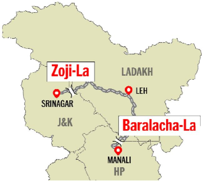
- Zojila Pass:
- Zoji La is a high mountain pass located in the Kargil district of Ladakh.
- The pass links Leh and Srinagar and provides an important link between Union Territories of Ladakh and Kashmir.
- It is vital for the movement of goods and personnel, especially for security forces stationed in Ladakh.
- Zoji la is known as the “Mountain Pass of Blizzards”.
- Zojila pass remains closed during winters due to heavy snowfall, cutting off Ladakh region from Kashmir.
- In 2018, the Zojila tunnel project was launched. The tunnel is Asia's longest and strategic bi-directional tunnel, which will provide all-weather connectivity between Srinagar, Kargil and Leh.
- The Border Roads Organisation (BRO) reopened Zojila Pass for traffic.
Galwan Valley
- Geographic Location:
- Galwan Valley lies between steep mountain ranges through which the Galwan River flows.
- The Galwan River originates in Aksai Chin (under Chinese control) and flows westward into Ladakh, where it merges with the Shyok River on the Indian side of the Line of Actual Control (LAC).
- The valley serves as a crucial corridor between western Ladakh and eastern Aksai Chin.
- Chinese Control:
- Aksai Chin, where the river begins, is administered by China as part of its Xinjiang Uyghur Autonomous Region.
- Proximity to Key Roads:
- On the Indian side, the valley is close to the Darbuk–Shyok–Daulat Beg Oldie (DSDBO) road, a strategic supply route.
- On the Chinese side, it lies near the G219 highway, a major road connecting Xinjiang and Tibet.
Border Roads Organisation (BRO)
- BRO was conceived and raised in 1960 by Pandit Jawaharlal Nehru for coordinating the speedy development of a network of roads in the North and the North Eastern border regions of the country.
- It works under the administrative control of the Ministry of Defence.
- It has diversified into a large spectrum of construction and development works comprising airfields, building projects, defence works and tunneling and has endeared itself to the people.
- Important programmes:
- In 2023-24, the BRO completed 125 infrastructure projects, including the construction of the Sela Tunnel in Arunachal Pradesh on Balipara-Chardwar-Tawang Road.
- The BRO will soon start construction on the 4.10-km long Shinkun La Tunnel, which will become the world’s highest tunnel at 15,800 ft once completed, bypassing China's Mila Tunnel at 15,590 ft.
Ladakh Autonomous Hill Development Council (LAHDC)
- About:
- LAHDC was established under the Ladakh Autonomous Hill Development Council Act, 1995.
- The creation of LAHDC introduced democratic decentralization of the planning process, enabling grassroots participation in decision-making.
- Significance:
- Given Ladakh’s challenging terrain and remote locations, the need for public involvement in planning and development was particularly critical.
- LAHDC’s structure allows for locally informed policies that address the unique needs of the region.


